Displaying 325 - 432 of 845
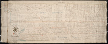
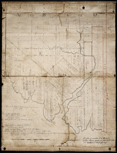
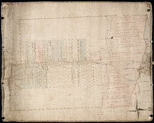
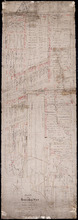
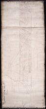
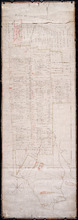
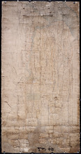
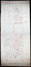
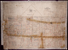
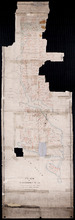
Plan of the Western Moiety of Township No.20: Grenville Parish, Queens County, P. E. Island
Description: Plan of the Western Moiety of Township No.20, showing residents.
Province: Prince Edward Island
Type: cadastral maps
Date Created: 1850
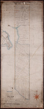
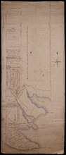
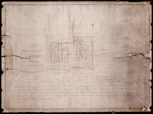
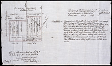
Plan of Lot & Township No. 22 in Prince Edward Island: Part of the Estate of the Right…
Description: Plan of Lot 22 (No.59). Sullivan Estate.
Province: Prince Edward Island
Type: cadastral maps
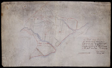
Lot 22
Description: Plan of Lot 22 showing residents.
Province: Prince Edward Island
Type: cadastral maps
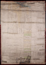
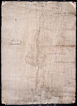
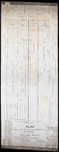
Plan of Township No. 24: Copied from plan furnished by Proprietors with numerous corrections from…
Description: Working plan of Lot 24 (No.67). Winsloe Estate. Surveyed by H.J Cundall and others; copied by Thos. MacKinlay.
Province: Prince Edward Island
Type: cadastral maps
Date Created: 1886-02
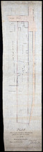
Lot 26
Description: Plan of Lot 26, partly finished by T. McKinlay. Residents shown for southern part of lot.
Province: Prince Edward Island
Type: cadastral maps
Plan of Township No. 26: Comprising the Holland, Stephens, and Thomson Estates Copied from the…
Description: Plan of Lot 26 (No.70) comprising the Holland, Stephens, and Thomson Estates copied from the plans in Public Lands Department, corrected by partial surveys and Meacham's Atlas. more
Province: Prince Edward Island
Type: cadastral maps
Date Created: 1885-09
Plan of Township 27: embracing Freeholds and the Pope and Cunard Estates. Compiled from Meacham…
Description: Plan of Lot 27 (No.73) embracing freeholds and the Pope and Cunard Estates. Compiled from Meacham's Atlas and the original leases. more
Province: Prince Edward Island
Type: cadastral maps
Date Created: 1885-09
A Plan of the Northern half Lot or Township No. 27 in Prince Edward Island: from an Actual Survey…
Description: Outline plan of northern half of Lot 27 (No.2).
Province: Prince Edward Island
Type: cadastral maps
Date Created: 1818
Eastern Division of Township No. 28
Description: Sketch of the eastern division of Lot 28 (No.33). DeBlois Estate.
Province: Prince Edward Island
Type: cadastral maps
Date Created: 1870-01-01
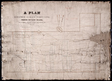
Prince Edward Island: divided into Counties & Parishes, with the Lots, as Granted by Government…
Description: Prince Edward Island divided into Counties and Parishes with the Lots as granted by Government, exhibiting all the New Settlements, Roads, Mills, etc. Published by H. Ashby, King Street, Cheapside,… more
Publisher: Ashby, H.
Province: Prince Edward Island
Type: cadastral maps
Date Created: 1798-03-01

Plan of Township No. 29: embracing the Fane and Melville Estates – 1883
Description: Plan of Lot 29 (No.80). Fane and Melville Estates.
Province: Prince Edward Island
Type: cadastral maps
Date Created: 1883

Lot 30: Refugee Share drawn for in Council this 18th day of September 1784, John Spencer
Description: Plan of Lot 30 (No.1) showing Refugee Shares drawn for in Council, 18 September, 1784.
Province: Prince Edward Island
Type: cadastral maps
Date Created: 1784

Plan of Township No. 30 belonging to R. Bruce Stewart, Drawn by Robt. Stewart 1861 from surveys…
Description: The map shows Lot 30 divided into numbered sub-lots. There are nine different series of sub-lot numbers which are colour-coded according to the map legend. The different colours represent Line Road,… more
Province: Prince Edward Island
Type: cadastral maps
Date Created: 1861

Plan of Township 30
Description: Plan of Lot 30 (No.82). Stewart Estate. Shows names of residents.
Province: Prince Edward Island
Type: cadastral maps
Lot 31: Southern portion
Description: Plan of the southern part of Lot 31, showing residents. In use 1819. From H.J. Cundall.
Province: Prince Edward Island
Type: cadastral maps

Lot 32
Description: Plan of Lot 32 showing some residents.
Province: Prince Edward Island
Type: cadastral maps

Plan of Township No. 33 in Prince Edward Island: Part of the Estate of John Hodges Winsloe Esq.…
Description: Plan of Lot 33. Winsloe Estate.
Province: Prince Edward Island
Type: cadastral maps
Date Created: 1834-09-20

Lot 34: Southern portion
Description: Part of Lot 34 (No.7). North side of Hillsborough River.
Province: Prince Edward Island
Type: cadastral maps

Plan of Lot 38
Description: Plan of Lot 38 showing the extent of land in possession of the Government...(?)
Province: Prince Edward Island
Type: cadastral maps

Plan of Lot or Township No. 39: from the lastest Surveys by Joseph Ball, S.G., July 1, 1857
Description: Plan of Lot 39 (No.104). Worrell Estate. Plan copied by Owen Curtis, 1876.
Province: Prince Edward Island
Type: cadastral maps
Date Created: 1857-07-01

Plan of Lot or Township No. 40: From latest Surveys by Joseph Ball and Owen Curtis, Land Surveyors.
Description: Plan of Lot 40 (No.109). Worrell Estate.
Province: Prince Edward Island
Type: cadastral maps

Plan of Lot or Township No. 41: From The Latest Surveys By Joseph Ball S.G., Copied by O. Curtis
Description: Plan of Lot 41 (No.111). Showing residents. Surveyed by Joseph Ball. Plan copied by Owen Curtis.
Province: Prince Edward Island
Type: cadastral maps

Lot 43: No. 1
Description: Plan of Lot 43 (No.1), showing Bay Fortune, Rollo Bay and North Shore areas.
Province: Prince Edward Island
Type: cadastral maps
Lot 43: Plan of that part of Division No. 1 Shaded Green on Lot or Township No. 43 containing 3467…
Description: Plan of that part of Lot 43 containing 3467 acres purchased by the Government.
Province: Prince Edward Island
Type: cadastral maps
Part of Lot 43
Description: Plan of part of Lot 43 (No.117). Townshend Estate.
Province: Prince Edward Island
Type: cadastral maps
Plan of Lot 44
Description: Plan of Lot 44. Old plan referred to in deed from Sir Ed. Cunard and others to the Commissioner for Public Lands, dated 13 July, 1866.
Province: Prince Edward Island
Type: cadastral maps
Date Created: 1866
Plan of Lot 45: Northern portion
Description: Plan of the northern part of Lot 45 (No.123), showing the names of some residents.
Province: Prince Edward Island
Type: cadastral maps

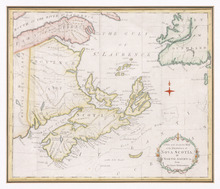
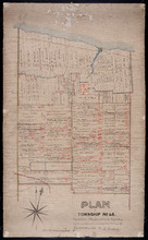
Plan of Township No. 64: St. Andrews Parish, Queens County, P. E. Island
Description: Lot 64 is situated in Kings County, not Queens County as stated in the map title. The map shows Lot 64 divided into parcels of land with names of residents and their acreage amounts. Several parcels… more
Province: Prince Edward Island
Type: cadastral maps
Date Created: 1850

Plan of the Western Portion of Township No. 65: containing 5250 acres and belonging to Mrs. Lydia…
Description: Plan of the western portion of Lot 65 (No.173). Estate of Mrs Lydia Wright. Roads, leased land[?] and freehold land on the Estate of Mrs. Lydia Wright. Tenant names appear on the sub-lots, which are… more
Province: Prince Edward Island
Type: cadastral maps
Date Created: 1841

Plan of Lot or Township No. 34
Description: Plan of Lot 34 (No. 90). Montgomery Estate. Working plan. The map shows Lot 34 divided into parcels of land with the names of residents and their acreage amounts handwritten in black ink. Land… more
Province: Prince Edward Island
Type: cadastral maps
Plan of the Division Line between Queens and Prince Counties & the Southern Boundary of…
Description: Plan of the division line between Queens and Prince Counties and the southern boundary of Lot 25 established by the Commissioners under the Boundary Line Act. Certified copy by G. Wright of 1835 plan… more
Province: Prince Edward Island
Type: boundary maps
Date Created: 1850
Plan of the Division Line between Queens and Prince Counties, & the Southern Boundary of…
Description: Plan of the division line between Queens and Prince Counties and the southern boundary of Lot 25, as established by the Commissioners under the Boundary Line Act. (No.81). The map shows the boundary… more
Province: Prince Edward Island
Type: boundary maps
Date Created: 1835
Plan of the Line dividing Kings and Queens Counties in Prince Edward Island as established by the…
Description: Plan of the line dividing Kings and Queens Counties in Prince Edward Island as established by the Commissioners under the provisions of the Act 4th: William 4th: Cap. 15 (No. 80). The map shows the… more
Province: Prince Edward Island
Type: boundary maps
Date Created: 1835

Office copy of that part of the Plan of the new line of Road leading from the Cardigan River to the…
Description: Plan of the new line of road leading from the Cardigan River to the Hillsborough River. Passes through Lots 51, 52, and 38. Plan copied by Geo. Wright, 12 August, 1837. The plan uses a dashed and… more
Province: Prince Edward Island
Type: engineering maps
Date Created: 1833
Plan of land appropriated by the Railway Commissioners in Lots 38 and 51
Description: Prince Edward Island Railway. Plan shows the land appropriated by the Railway Commissioners in Lots 38 and 51. The rail line is drawn in pink. Roads are shown in a lighter colour. Names of residents… more
Province: Prince Edward Island
Type: engineering maps
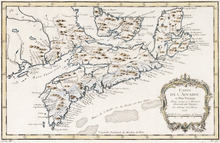
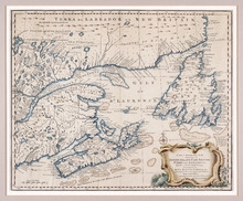
Carte de l'Accadie et Païs Voisins pour servir a l'Histoire Generale des Voyages: Par M.B…
Description: Rectangular map engraved on paper; framed and covered with glass. Coloured. Depicts Nova Scotia, P.E.I., Cape Breton, and part of New Brunswick; all place names in French. Highland areas in brown.… more
Province: Nova Scotia, New Brunswick, Prince Edward Island
Type: chorographic maps
Date Created: 1757
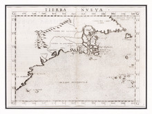
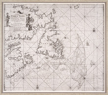
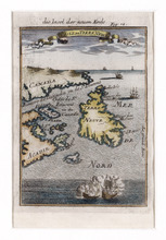
Tierra Nueva
Description: Rectangular black and white engraved map on paper; framed under glass. Map depicts eastern part of Canada including Cape Breton and Newfoundland. Shape rectangular Additional associations Frame HF.94… more
Type: chorographic maps
Date Created: 1561
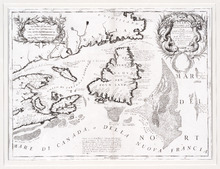
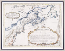
Canada Orientale nell' America Settentrionale: descritta dal P. Mro. Coronelli M C Cosmografo…
Description: Rectangular map, black on white paper. The map shows Newfoundland; Prince Edward Island; Anticosti Island; Cape Breton; part of mainland Nova Scotia; part of New Brunswick; part of Quebec; and part… more
Province: Newfoundland, Nova Scotia, Prince Edward Island
Type: topographic maps
Date Created: 1695
Pas-kaart, Vande Zee-Kusten van, Terra Nova, Met de Byleggende Zee-Kusten van Francia Nova Canada…
Description: Rectangular engraved map of Newfoundland, Nova Scotia, Prince Edward Island, and part of Quebec; framed and covered with glass. Black and white. Depicts Newfoundland, Nova Scotia, Cape Breton, Prince… more
Province: Newfoundland, Nova Scotia, Prince Edward Island, Quebec
Type: topographic maps
Date Created: 1687
A New and Accurate Map of the Islands of Newfoundland, Cape Briton, St. John and Anticosta:…
Description: Map, showing the Maritime provinces; the vertical fold indicates that it originally appeared in a book or atlas; cartouche in bottom right corner. Port Joy is the only settlement named on Isle St.… more
Publisher: Astron Obervat
Province: Nova Scotia, Newfoundland, Cape Breton, St. John, Anticosta
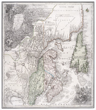
Carte d'Une Partie de l'Amérique Septentrionale : Pour Servir à l'Intelligence du…
Description: Framed map of America in French, Title and a table of explanation along with an Avertissement are inside an elborate design. The map also shows bodies of water such as Lac Erie and Ontario, towns and… more
Province: Nova Scotia, Prince Edward Island, New Brunswick, Newfoundland
Type: topographic maps
Date Created: 1751
Partie Orientale de la Nouvelle France ou du Canada Avec L'Isle de Terre-Neuve et de Nouvelle…
Description: Map, image: elaborate decorations of ships and such figures as Neptune, Mercury and an allegorical figure representing the spirit of cartography who holds scales and a compass. Other embellishments… more
Type: pictorial maps, topographic maps
A New and Accurate Map of the Province of Nova Scotia, in North America, From the Latest…
Description: Framed map of the province of Nova Scotia and vicinity. The map shows bodies of water such as the Gulf of St. Lawrence and Bay of Fundy, towns, cities, villages, islands, banks, and a compass rose.
Province: Nova Scotia
Type: topographic maps, pictorial maps
Date Created: 1773

L'ACADIE: Par le Sr. Robert de Vaugindy Fils de Mr. Robert Geogr. ord, du Roy, Avec Privilege
Description: Period designation 18th century. The map shows bodies of water such as Baye Francoise, villages, towns, cities, mountains, trees, islands, and banks.
Province: Nova Scotia, Prince Edward Island
Type: topographic maps
Date Created: Unknown year in the century of the 1700s
Die Insel der Neuen Erde : Isle de Terre New
Description: Two maps of Acadia in the 18th century in one frame; .1 coloured, .1 uncoloured. The map shows Canada, Acadie, and Terre Neuve, islands, water, and paintings of ships.
Type: pictorial maps
Date Created: 1690
Die Insel der Neuen Erde : Isle de Terre Newe
Description: Two maps of Acadia in the 18th century in one frame; .1 coloured, .1 uncoloured.The map shows Canada, Acadie, and Terre Neuve, islands, water, and paintings of ships.
Province: Newfoundland, Nova Scotia, New Brunswick, Prince Edward Island
Type: topographic maps
Date Created: 1690

Carta Geographica Del Canada Nell' America Settentrionale
Description: Framed map of Canada; cartouche top left corner: natives by a pond with deer and animals which are part dog, part fish. The map shows bodies of water such as Baja D' Hudson, villages, towns, and… more
Type: chorographic maps
Date Created: 1700 to 1799
Plan of 500 Acres of Land as fixed on by Mr. Langdon being part of Mrs. Burns Land of 7800 Acres.:…
Description: Plan of part of Lot 38 (No. 5). 500 acres, the property of Mr. Langdon, being part of Mrs. Burns' land of 7800 acres. The maps shows a square parcel of land, 500 acres in size, belonging to Mr.… more
Province: Prince Edward Island
Type: cadastral maps
Date Created: 1809-08
Plan Shewing the Northern Boundary Line of the Victoria Park Roadway as Surveyed by Thomas W. May L…
Description: Plan showing the northern boundary line of the Victoria Park Roadway. This is the plan referred to in "The Victoria Park Roadway Act, 1896". Shown is the Charlottetown Harbour, Governor… more
Province: Prince Edward Island
Type: cadastral maps
Date Created: 1896

Plan Shewing the Eligible Situation of Acre Lots on the Estate of the Honble. J. C. Pope. in the…
Description: Plan showing the eligible situation of acre lots on the estate of Hon. J.C. Pope in the Royalty of the city of Charlottetown. Royalty Lots No.85, No.95 and No.97. (No.386)
Province: Prince Edward Island
Type: cadastral maps
Date Created: 1878
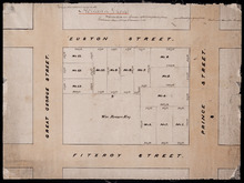
Holland Grove
Description: Plan of the block of land between Euston Street and Fitzroy Street and Prince Street and Great George Street known as Holland Grove. Town Lots 18-22 and 63-67 in the fifth hundred.
Province: Prince Edward Island
Type: cadastral maps
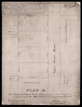
Plan A. Of 4 Pleasantly Situated Building Lots, fronting on Upper Prince Street, The property of…
Description: Plan "A" of four pleasantly situated lots fronting on Upper Prince Street, the property of the Hon. T.H. Haviland, Common Lot No.24. (No.60) more
Province: Prince Edward Island
Type: cadastral maps
Date Created: 1886

Plan of St. Avard's divided into Building Lots part of the Estate of the Honble. James C. Pope…
Description: Plan of St. Avards divided into building lots, part of the estate of the Hon. James C. Pope in the Royalty of Charlottetown. Royalty Lot No.13. Also shown are St. Peters Road, and Mt. Stewart Road.
Province: Prince Edward Island
Type: cadastral maps
Date Created: 1878

Plan showing the situation of part of the Estate of the late Owen Connolly Esq. in Charlottetown…
Description: Plan showing the situation of part of the Estate of the late Owen Connolly in Charlottetown Common and Royalty. Created by John Ball, surveyor, and copied by Thomas W. May. The map shows Malpeque… more
Province: Prince Edward Island
Type: cadastral maps
Date Created: 1921-01
Plan of Lot 41
Description: Plan of Lot 41. Shows names of some residents. The map also shows St. Peters Bay and the Gulf of St. Lawrence.
Province: Prince Edward Island
Type: cadastral maps

Plan of 1390 Acres of Land part of Township No. 65: The property of the Hon,, Smauel Cunard…
Description: Plan of part of Lot 65 (No.172). 1390 acres of land, part of the property of the Hon. Samuel Cunard. One of the plans referred to in the Deed from Sir Edward, William, and Laura Cunard to the… more
Province: Prince Edward Island
Type: cadastral maps
Date Created: 1866-07-13
Plan of Township No. 54: Chiefly from Surveys by Geo. Wright and Rodk. Campbell copied By Owen…
Description: Plan of Lot 54, chiefly from surveys by Geo. Wright and Rod'k Campbell. Copied by Owen Curtis, 1877. Shows names of residents, acreage, and land conveyance references, roads, bodies of water,… more
Province: Prince Edward Island
Type: cadastral maps
Date Created: 1877
Plan of an approximate correction of the Junction of the Maitland road with the Murray Harbour Road…
Description: Plan of an approximate correction of the Junction of the Maitland Road with the Murray Harbour Road as sketched in sundry plans by the late Roderick Campbell... and as measured on the ground on the… more
Province: Prince Edward Island
Type: cadastral maps
Date Created: 1921-09-09
Plan of Lot or Township No. 58: Copied from Surveys of Rodk. Campbell. L. S. by Owen Curtis. L. S.
Description: Plan of Lot 58 (No.155). Shows names of residents, acreage, and land conveyance references. Surveyed by Rod'k Campbell and copied by Owen Curtis. The map shows roads, and bodies of water such as… more
Province: Prince Edward Island
Type: cadastral maps
Plan of part of Lot 56
Description: Plan of part of Lot 56 showing the names of residents, acreage, a few land conveyance references, and roads. (No.151)
Province: Prince Edward Island
Type: cadastral maps
Date Created: 1882
Plan of the Fane Melville and Selkirk Estates on Township No. 53: By Owen Curtis LS
Description: Plan of the Fane, Melville, and Selkirk Estates on Lot 53 (No.142). Unfinished plan. Shows names, acreage, and land conveyance references for some residents. The map also shows roads such as… more
Province: Prince Edward Island
Type: cadastral maps
Plan of Part Township No. 53 the Estate of the Honourable Lady Cecily J. G. Fane
Description: Plan of part of Lot 53 (No.143). The estate of the Honourable Lady Cecily J.G. Fane. Shows names of residents and acreage. Signed by G.W. DeBlois, Att'y for Landlord. The map also shows bodies… more
Province: Prince Edward Island
Type: cadastral maps
Plan of that part of Township Number Forty-nine, in Prince Edward Island, the Property of the Hon.…
Description: Plan of part of Lot 49, the property of the Hon. Edward C. Haythorne and Robert Poore Haythorne. Tracts shaded green sold with the Act 28 Vic. Cap.5. (No.133). Shows names of residents and acreage,… more
Province: Prince Edward Island
Type: cadastral maps
Date Created: 1857-01
Plan of the eastern part of Lot 48 and the southern part of Lot 36
Description: Plan of the eastern part of Lot 48 and the southern part of Lot 36. Area around the Monaghan Road. Shows names of residents. (No.132)
Province: Prince Edward Island
Type: cadastral maps
Plan of the Eastern Moiety of Township No. 46 East Parish. Kings County. P. E. Island.
Description: Plan of the eastern moiety of Lot 46, East Parish, Kings Co. (No.125). Cunard Estate. Shows names of residents and acreage, roads, and the Gulf of St. Lawrence. One of the plans referred to in the… more
Province: Prince Edward Island
Type: cadastral maps
Date Created: 1866
A Plan of the Eastern Moiety of Township No. 46 From the Survey of H. J. Cundall L. S. By Owen…
Description: Plan of the eastern half of Lot 46. (No.126) created by Owen Curtis and R.A. Strong from the survey by H.J. Cundall. Shows names of residents, acreage, and land conveyance references, bodies of water… more
Province: Prince Edward Island
Type: cadastral maps
Plan of Township No. 45. Copied from Plan furnished by Proprietors, and amended and corrected from…
Description: Plan of the northern part of Lot 45 copied from Plan furnished by Proprietors and amended and corrected from surveys by J.C. Underhay (No.124). Cunard Estate. Shows names of residents, acreage, land… more
Province: Prince Edward Island
Type: cadastral maps
Plan of part of Lot 44
Description: Plan of part of Lot 44. Area east of the Bear River Road. Shows names of residents.
Province: Prince Edward Island
Type: cadastral maps
Plan of Lot 44 (No.119)
Description: Plan of Lot 44 (No.119). Cunard Estate. Shows names of some residents, acreage, and some land conveyance references, bodies of water such as the Gulf of St. Lawrence, rivers, roads, and a nautical… more
Province: Prince Edward Island
Type: cadastral maps
Plan of the southern part of Lot 43
Description: Plan of the southern part of Lot 43. Shows names of residents and acreage, bodies of water such as rivers (Fortune), bays (Rollo), capes, roads, division lines, and a nautical compass. (Townshend)
Province: Prince Edward Island
Type: cadastral maps
A Plan of Part of Township No. Forty Three. The Property of Hon. T. H. Haviland. Surveyed October…
Description: Plan of part of Lot 43. The property of Hon. T.H. Haviland. One of the plans referred to in the Deed from Hon. T.H. Haviland and wife to the Commissioner of Public Lands, 1869. Shows names and… more
Province: Prince Edward Island
Type: cadastral maps
Date Created: 1868-10
Plan of Township No 42: from Surveys by O. Curtis, August 1864
Description: Plan of Lot 42. Shows names of some residents and acreage, bodies of water such as the Gulf of St. Lawrence, roads, and a compass.
Province: Prince Edward Island
Type: cadastral maps
Date Created: 1864-08
Plan of the western half of Lot 40 and Lot 39 east of Morell River
Description: Plan of the western half of Lot 40 and the part of Lot 39 east of Morell River. Shows names of residents and acreage, bodies of water such as bays, and rivers, and roads.
Province: Prince Edward Island
Type: cadastral maps
A Plan of 1068 Acres of Land on Lot 40, The Property of Hon. T. H. Haviland
Description: Plan of part of Lot 40 (No.108). 1068 acres of land, the property of Hon. T.H. Haviland. One of the plans referred to in the Deed from Hon. T.H. Haviland and wife to the Commissioner of Public Lands… more
Province: Prince Edward Island
Type: cadastral maps
Date Created: 1868-08
A Map and Survey Of Marshes east of Mount Stewart Bridge on the north side of Hillsborough River in…
Description: A map and survey of marshes east of Mount Stewart Bridge on the north side of Hillsborough River in Lot 37 being formerly part of the Wiggin's Estate. (No.21). Also shown is the Hillsborough… more
Province: Prince Edward Island
Type: cadastral maps
Date Created: 1885-01
A Plan of Glenaladale, The property of the Heirs of the late Honbl. Donald McDonald
Description: Plan of part of Lot 36 (No.98), Glenaladale, the property of the Heirs of the late Hon. Donald McDonald. Shows names of residents, acreage, and a few land conveyance references, bodies of water such… more
Province: Prince Edward Island
Type: cadastral maps
Date Created: 1856
Plan of that part of Township No. Thrity five in Prince Edward Island known by the name of the…
Description: Plan of part of Lot 35 (No.93). Known by the name of Glenfinn Estate, the property of the Heirs of the late Alexander McDonell of Donaldston containing an area of 1609 acres. The map shows roads, and… more
Province: Prince Edward Island
Date Created: 1859-12
Plan of a part of Township Number Thirty Five (35) on the south side of the Hillsborough River.
Description: Plan of Lot 35, south side of the Hillsborough River (No.92). Shows names of residents, acreage, and some land conveyance references, river, and roads.
Province: Prince Edward Island
Type: cadastral maps
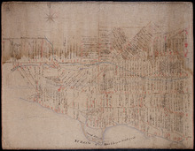
Plan of the city of Charlottetown
Description: Plan of the city of Charlottetown. Shows the location of the 1st to the 5th Hundred and the Town Lots situated thereon.
Province: Prince Edward Island
Type: cartograms map
Plan shewing the situation of Malcolm Levingstone's Farm on Lot or Township No. 31, in…
Description: Plan of part of Lot 31. The map shows Malcolm Levingstone's farm of 56 ½ acres, coloured green, on the Baltic Road in Lot 31. The plan also shows the adjoining parcels of land and those on the… more
Province: Prince Edward Island
Type: cadastral maps
Date Created: 1865-12-26
Plan of the property of Mrs. S.W. Smith situated on Township No. 33 in Prince Edward Island
Description: Plan of part of Lot 33. The property of Mrs S.W. Smith. The map shows Winter River, and roads (Brackley Point), (Union), and a compass.
Province: Prince Edward Island
Type: cadastral maps
A Plan of 1068 Acres of Land on Lot 40, The Property of Hon. T. H. Haviland
Description: Plan of part of Lot 40 (No.108). 1068 acres of land, the property of Hon. T.H. Haviland. One of the plans referred to in the Deed from Hon. T.H. Haviland and wife to the Commissioner of Public Lands… more
Province: Prince Edward Island
Type: cadastral maps
Date Created: 1868-08
Plan Shewing the situation of that part of Water Lot No. 7. at Charlottetown Sold to Henry Beer Esq.
Description: Plan showing the situation of that part of Water Lot No.7 at Charlottetown sold to Henry Beer. (No.26) (Also No.216 Queens County). The map shows streets such as Great George, Prince, Water, wharfs,… more
Province: Prince Edward Island
Type: cadastral maps
Date Created: 1881
Plan Shewing the situation of Water Lot No. 8, and that part of Water Lot No. 7 conveyed to Ronald…
Description: Plan showing the situation of Water Lot No.8 and that part of Water Lot No.7 conveyed to Ronald MacMillan. The map also shows streets such as Water street, Prince, lots, Ferry Wharf, and Hillsborough… more
Province: Prince Edward Island
Type: cadastral maps
Plan of part of Charlottetown showing Pownal Wharf and Lot No.5
Description: Plan of part of Charlottetown showing Pownal Wharf and part of Town Lot No.5 located in 1st Hund. Also shown are buildings and wharfs.
Province: Prince Edward Island
Date Created: 1868-08
Plan of Lot or Township No. 66: from the latest Surveys by Jos. Ball S. G. Surveyor General's…
Description: Plan of Lot 66. Copied by Thomas W. May, July 8, 1921. This copy of an earlier map shows Lot 66 divided into numbered parcels of land. A list down the right side gives the residents' names and… more
Province: Prince Edward Island
Type: cadastral maps
Date Created: 1856-08-04
Plan of the western part of Lot 16
Description: Plan of the western part of Lot 16. Shows names of residents, acreage, and a few land conveyance references. The map shows bodies of water, roads, other lots such as 15, and 18 in Indian River, a… more
Province: Prince Edward Island
Type: cadastral maps
Date Created: 1880-01-24
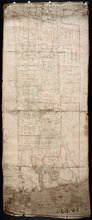
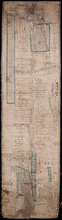
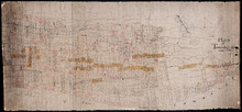
Plan of Township No. 20
Description: Plan of the western moiety of Lot 20 (No.50). Copy of the plan deposited by vendors of the Cunard Estate. The map also shows bodies of water such as rivers, creeks, and ponds, and roads.
Province: Prince Edward Island
Type: cadastral maps
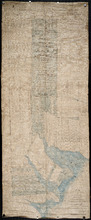
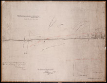
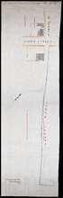
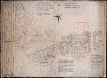
Plan of the Western Moiety of Township, No. 20. Situate in Grenville Parish. Queens Co. P.E.Island…
Description: Plan of the Western Moiety of Lot 20 situate in Grenville Parish (No.49). Includes that part of Lot 20 south of the South West River. Shows names of residents and acreage, bodies of water such as… more
Province: Prince Edward Island
Type: cadastral maps
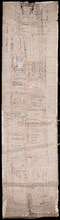
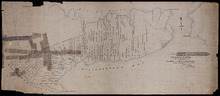
Eastern Moiety of Township No. 20
Description: Plan of the eastern moiety of Lot 20. Color code shows property of William Cundall, Louisa Montgomery, Eliza M. Cundall and Henry J. Cundall. Cundall Estate (No.51). Shows names of residents and… more
Province: Prince Edward Island
Type: cadastral maps
Plan of the French Marsh: Lot 37 - No. 10
Description: Plan of part of Lot 37 (Nos. 10 and 58). This item consists of three maps on three separate sheets, all showing the same area. The maps show the French Marsh on the north side of the Hillsborough… more
Province: Prince Edward Island
Type: cadastral maps, topographic maps
A Plan of Ronald McDonalds Land of Grand Tracadie For The Surveyors Generals Office
Description: Plan of part of Lot 35 (No. 5). The map shows 175 acres of land belonging to Ronald McDonald at Grand Tracadie in the northern part of Lot 35. The map shows the names of the residents on either side… more
Province: Prince Edward Island
Type: cadastral maps
Date Created: 1824-08-03
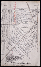
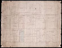
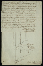
Plan of part of Lot 21: No. 55
Description: The map shows the southern portion of Lot 21 divided into parcels of land with the names of resident and their acreage amounts. Some parcels are outlined in red. Land conveyance information appears… more
Province: Prince Edward Island
Type: cadastral maps
Plan of part of Township No. 21 Grenville Parish, Queens County P.E.Island: H.J. Cundall delt 1850
Description: Plan of the northern part of Lot 21 (No.56). Cunard Estate. One of the plans referred to in the deed from Sir Edward, William, and Laura Cunard to the Commissioner of Public Land, July 13, 1866.… more
Province: Prince Edward Island
Type: cadastral maps
Date Created: 1850
Plan of part of Township No. 21: Copied from a Plan of H,J, Cundall's
Description: Plan of the northern part of Lot 21 (No.57). Cunard Estate. Shows names of residents, acreage, and some land conveyance references, bodies of water such as rivers, and the Gulf of Saint Lawrence,… more
Province: Prince Edward Island
Type: cadastral maps
Part of Township No. 21: in Prince Edward Island
Description: Plan of the southern half of Lot 21. One of the plans referred to in the Deed from Sir Edward, William and Laura Cunard to the Commissioner of Public Land, July 13, 1866. Shows names of residents,… more
Province: Prince Edward Island
Type: cadastral maps

Plan of Township No. 67 in Prince Edward Island: The Property of Lady Wood
Description: Plan of Lot 67 (No.180). The property of Lady Wood. Shows names of residents, acreage, and some land conveyance references and a compass pointing North.
Province: Prince Edward Island
Type: cadastral maps
Date Created: 1858
Plan of 1390 Acres of Land part of Township No. 65: The Property of the Honble. Samuel Cunard.…
Description: Plan of Lot 65 (No.178). Shows names of residents, acreage, and land conveyance references. Color code indicates freehold land and the estates of the Wrights, Cunard and Cumberland. Shows bodies of… more
Province: Prince Edward Island
Type: cadastral maps
Plan of Part of Township No. 65: The Property of Col. B.H. and Mrs Cumberland
Description: Plan of part of Lot 65 (No.171). The property of Col. B.H. and Mrs Cumberland. Shows names of residents and acreage. Plan copied by R.T. Weeks. The map shows bodies of water such as Elliott River,… more
Province: Prince Edward Island
Type: cadastral maps
Plan of Township 64
Description: Plan of Lot 64 (No.169). Cunard Estate. Shows names of residents, acreage, and land conveyance references. The map shows bodies of water such as Gulf of Saint Lawrence, and Murray River, Murray… more
Province: Prince Edward Island
Type: cadastral maps
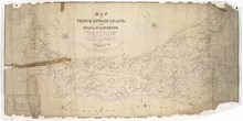
Map of Prince Edward Island, in the Gulf of St. Lawrence,: Compiling the latest Topographical…
Description: Map of Prince Edward Island by George Wright, Surveyor General, 1852. The Sea Coast, Rivers, Vc. being laid down from the Survey recently completed by Captain H. W. Bayfield R.N. The map shows mail… more
Province: Prince Edward Island
Type: cadastral maps
Date Created: 1852
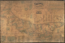
Topographical Map of Prince Edward Island in the Gulf of St. Lawrence
Description: Prince Edward Island divided into Counties and Parishes with the Lots as granted by Government, exhibiting all the New Settlements, Roads, Mills, etc. Published by H. Ashby, King Street, Cheapside,… more
Publisher: W. E. & H. H. Baker
Province: Prince Edward Island
Type: topographic maps, cadastral maps, pictorial maps
Date Created: 1863
Plan of Lot 63
Description: Plan of Lot 63. Shows names of residents, acreage, and land conveyance references. The map shows bodies of water such as Murray Bay/River, Gulf of St. Lawrence, and Murray Islands.
Province: Prince Edward Island
Type: cadastral maps

A Plan of the undisposed of Parts of Lot No. 62 in Queens County in Prince Edward Island by Rodk.…
Description: A plan of the undisposed part of Lot 62. Selkirk Estate (No.164). Shows names of residents and acreage.
Province: Prince Edward Island
Type: cadastral maps
Date Created: 1860
Plan of Lot 62 (No.165)
Description: Plan of Lot 62 (No.165). Selkirk Estate. Shows names of residents, acreage, and land conveyance references. The map shows a division line, bodies of water, Wood Islands, lots, landowners, acreage,… more
Province: Prince Edward Island
Type: cadastral maps
Plan of Township No. 55: From various Surveys made between the Years 1818 and 1845
Description: The map is a Plan of Township No. 55. The mqp shows bodies of water such as the Cardigan River, and Boughton River, lots, landowers, acreage, and Boughton Island.
Province: Prince Edward Island
Type: cadastral maps
Date Created: 1848-03-21