| Title Proper |
Atlas of Province of Prince Edward Island, Canada and the World
|
|---|---|
| Description |
Cummins devotes most of its opening pages to a detailing of the Island’s contribution to the First World War or “European War”. This event had forever changed many communities on the Island.
More positively, new industries such as silver fox farming are also highlighted as are the continuing growth of the potato and lobster industries which would both become increasingly important in the 20th century. |
| Access Condition |
This material is provided for research, education, and private use only.
|
| Type | |
| Physical Location |
Robertson Library, UPEI
|
| Contributors |
Cartographer: Cummins Map Co
|
| Date Issued |
1927
|
| Publisher |
Cummins Map Co.
|
| Extent |
140, lxxii p. : ill.
|
| Subject (Geographic) |
Atlas of Province of Prince Edward Island, Canada and the World
In this collection
Displaying 1 - 27 of 153
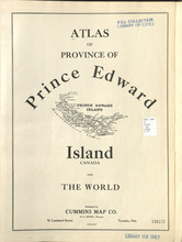
Title Page
Description: Title page of Atlas of Province of Prince Edward Island, Canada and the World
Province: Prince Edward Island
Type: text
Date Issued (Source): 1927
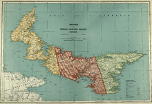
Province of Prince Edward Island, Canada: Cummins Map Co. Toronto
Description: The map shows all of Prince Edward Island and some of New Brunswick and Nova Scotia. Shown through a table of Counties are bays, roads, marshes, rapids, Indian Reserves, Lighthouses, depth of water,… more
Province: Prince Edward Island
Type: cadastral maps
Date Issued (Source): 1927
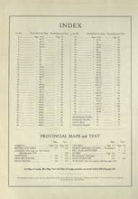
Index
Description: An index to the lots and rural directories found in the atlas as well as maps of Canadian provinces.
Province: Prince Edward Island
Type: text
Date Issued (Source): 1927
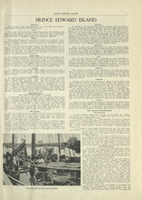
Prince Edward Island - 1
Description: The text provides information for the history, landscape, and various industries such as fishing on the island.
Province: Prince Edward Island
Type: text
Date Issued (Source): 1927
Prince Edward Island - 2
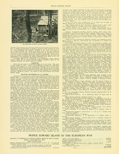
Description: The text provides information for the current events of the island in 1770's, the fur trade and Prince Edward Island's role in the European War. more
Province: Prince Edward Island
Type: text
Date Issued (Source): 1927
Prince Edward Island - 3
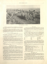
Description: The text provides information on the more specific details about Prince Edward Island's involvement in the European war, going into detail about the different battalions that were supported. more
Province: Prince Edward Island
Type: text
Date Issued (Source): 1927
Prince Edward Island - 4
Description: The text provides information on the more specific details about Prince Edward Island's involvement in the European war, going into detail about the different battalions that were supported. more
Province: Prince Edward Island
Type: text
Date Issued (Source): 1927
Introduction to the Province of Prince Edward Island - 5 - Page 5
Description: Text provides a list of the different divisions in the 105th battalion and the men enlisted in each division from Prince Edward Island.
Province: Prince Edward Island
Type: text
Date Issued (Source): 1927
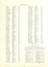
Military Directory - 98th Siege Battery - Page 6
Description: A directory listing of enlisted men in the 98th Siege Battery from Prince Edward Island.
Province: Prince Edward Island
Type: text
Date Issued (Source): 1927
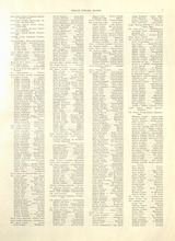
Military Directory - 105th Battalion - 1
Description: A directory listing of officers and men enlisted in the 105th regiment of the 105th battalion from Prince Edward Island
Province: Prince Edward Island
Type: text
Date Issued (Source): 1927
Military Directory - 105th Battalion - 2
Description: A directory listing of officers and men enlisted in the 105th regiment of the 105th battalion from Prince Edward Island
Province: Prince Edward Island
Type: text
Date Issued (Source): 1927
Military Directory - 105th Battalion - 3
Description: A directory listing of officers and men enlisted in the 105th regiment of the 105th battalion from Prince Edward Island
Province: Prince Edward Island
Type: text
Date Issued (Source): 1927
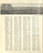
Military Directory - 105th Battalion - 4
Description: A directory listing of officers and men enlisted in the 105th Regiment, No. 12 Reinforcement Draft Canadian Railway Troops, 28th Draft Canadian Railway Troops, and No. 5 Siege Battery of the 105th… more
Province: Prince Edward Island
Type: text
Date Issued (Source): 1927
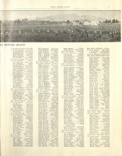
Military Directory - 105th Battalion - 5
Description: A directory listing of of officers and men draft enlisted for No. 5 Siege Battery, drafted for 10th Battalion, recruited for the Navy, and killed in action from Prince Edward Island
Province: Prince Edward Island
Type: text
Date Issued (Source): 1927
Military Directory - 105th Battalion - 6
Description: A directory listing of officers and men killed in action in the Prince Edward Island's Honor Roll from Prince Edward Island more
Province: Prince Edward Island
Type: text
Date Issued (Source): 1927
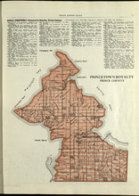
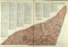
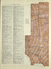
Princetown Royalty: Prince County
Description: The map shows Princetown Royalty in Prince County. Shown are rivers, bays, roads, landowners, acreage, and towns. Atlas of Province of Prince Edward Island, Canada and the World
Province: Prince Edward Island
Type: cadastral maps
Date Issued (Source): 1927
Lot No. 1 : Prince County
Description: The map shows Lot 1 in Prince county. Shown are the Gulf of St. Lawrence, ponds, rivers, creeks, landowners, acreage, roads and a railroad.
Province: Prince Edward Island
Date Issued (Source): 1927
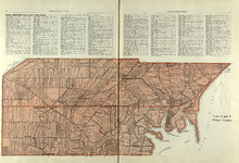
Lots 2 & 3 : Prince County
Description: The map shows lots 2 & 3 in Prince county. Shown are the Gulf of St. Lawrence, capes, ponds, landowners, acreage, rivers, and roads.
Province: Prince Edward Island
Type: cadastral maps
Date Issued (Source): 1927
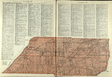
Lots 4 : Prince county
Description: The map shows Lots 4
Province: Prince Edward Island
Type: cadastral maps
Date Issued (Source): 1927
Rural Directory - Lots 4 - 6, Prince County
Description: A directory listing of residents of lots 4, 5, and 6.
Province: Prince Edward Island
Type: text
Date Issued (Source): 1927
Lot 6: Prince County
Description: The map shows Lot 6 in Prince county. Shown are roads, landowners, acreage, railroad, rivers, and Oyster creek
Province: Prince Edward Island
Date Issued (Source): 1927
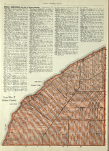
Lot No. 7: Prince County
Description: The map shows Lot 7 in Prince county. Shown are capes, coves, roads, landowners, and acreage.
Province: Prince Edward Island
Type: cadastral maps
Date Issued (Source): 1927
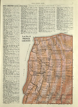
Lot No. 8: Prince County
Description: The map shows Lot 8 in Prince County. Shown are the Nothumberland Strait, Wolf Inlet, Landowners, acreage, and roads.
Province: Prince Edward Island
Type: cadastral maps
Date Issued (Source): 1927

Lot No. 9: Prince County
Description: The map shows Lot 9 in Prince county. Shown are roads, Egmont Bay, Dog Cove, roads, and railroads.
Province: Prince Edward Island
Type: cadastral maps
Date Issued (Source): 1927
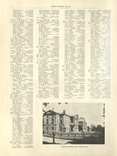
Rural Directory - Lots 9 and 10, Prince County
Description: A directory listing of residents of lots 9 and 10.
Province: Prince Edward Island
Type: text
Date Issued (Source): 1927
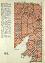
Lot 10: Prince County
Description: The map shows Lot 10 in Prince county. Shown are rivers, roads, landowners, and acreage.
Province: Prince Edward Island
Type: cadastral maps
Date Issued (Source): 1927
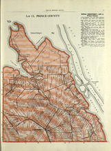
Lot 11: Prince County
Description: The map shows lot 11 in Prince county. Shown are roads, landowners, acreage, the Gulf of St. Lawrenece, Sand Hills, The Narrows, Cascumpeque Baym Foxley River, and Cavendish Inlet.
Province: Prince Edward Island
Type: cadastral maps
Date Issued (Source): 1927