| Title Proper |
Atlas of the Maritime Provinces of the Dominion of Canada with historical and geological descriptions
|
|---|---|
| Subtitle |
drawn on the rectangular polyconic projection from the British Admiralty charts, the National Boundary Survey, official plans, railway surveys, latest and most reliable maps, and new surveys made by the Authors
|
| Access Condition |
This material is provided for research, education, and private use only.
|
| Type | |
| Physical Location |
Robertson Library, UPEI
|
| Contributors |
Cartographer: Roe Brothers
|
| Date Issued |
1878
|
| Publisher |
Roe Brothers
|
| Extent |
99 p. : ill. ; 34 cm.
|
| Subject (Geographic) |
Atlas of the Maritime Provinces of the Dominion of Canada with historical and geological descriptions
In this collection
Displaying 1 - 27 of 37

Geological Maps of the Maritime Province: of the Dominion of Canada
Description: The map shows the geology of the Maritime Province. Shown are provinces of New Brunswick, Nova Scoita and Cape Breton Island, Prince Edward Island, and Newfoundland as an insert. Other objects shown… more
Province: Prince Edward Island, New Brunswick, Nova Scotia, Cape Breton Island
Type: geological maps
Date Issued (Source): 1878
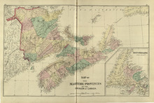
Map of the Maritime Provinces: of the Dominion of Canada
Description: The map shows the geology of the Maritime Province. Shown are provinces of New Brunswick, Nova Scoita and Cape Breton Island, Prince Edward Island, and Newfoundland as an insert. Other objects shown… more
Province: Prince Edward Island, New Brunswick, Nova Scotia, Cape Breton Island
Type: geological maps
Date Issued (Source): 1878
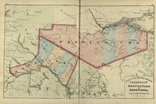
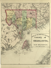
Counties of Restigouche and Madawaska: New Brunswick
Description: The maps shows the counties of Restigouche and Madawaska. Shown are Resitgouche Harbour, cities, towns, and lakes.
Province: New Brunswick
Type: geographical maps
Date Issued (Source): 1878
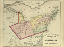
County of Gloucester: New Brunswick
Description: The map shows the county of Gloucester in New Brunswick. Shown are bays, railroads and stations, harbours, rivers, roads, towns and cities.
Province: New Brunswick
Type: geological maps
Date Issued (Source): 1878
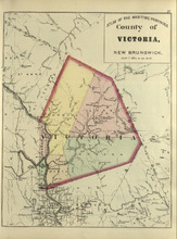
County of Victoria: New Brunswick
Description: The maps shows the county of Victoria in New Brunswick. Shown are rivers, brooks, Grand Falls, railroads and stations.
Province: New Brunswick
Type: geographical maps
Date Issued (Source): 1878
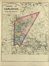
County of Carleton: New Brunswick
Description: The map shows the county of Carleton in New Brunswick. Shown are raods, railroads, towns, cities, and lakes.
Province: New Brunswick
Type: geographical maps
Date Issued (Source): 1878
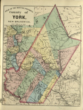
County of York: New Brunswick
Description: The map shows the county of York in New Brunswick. Shown are railroads and stations, St. Mary Ferry, Nashwaak Bridge, mills, lakes, MacAdam Junction, post offices, cities, and towns.
Province: New Brunswick
Type: geographical maps
Date Issued (Source): 1878
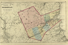
County of Northumberland: New Brunswick
Description: The map shows the county of Northumberland in New Brunswick. Shown are bays, lakes, rivers, railroads, towns, and cities.
Province: New Brunswick
Type: geological maps
Date Issued (Source): 1878
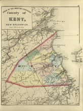
County of Kent: New Brunswick
Description: The map shows the county of Kent in New Brunswick. Shown are bays, rivers, mills, braches, Langhilins road, and Shediac Bridge.
Province: New Brunswick
Type: geological maps
Date Issued (Source): 1878
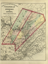
Counties of Sunbury and Queens: New Brunswick
Description: The map shows the counties of Sunbury and Queens in New Brunswick. Shown are railroads, stations and junctions, rivers, lakes, and creeks.
Province: New Brunswick
Type: geological maps
Date Issued (Source): 1878
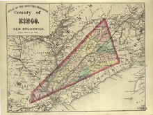
County of Kings, New Brunswick
Description: The map shows the county of Kings in New Brunswick. Shown are rivers, railroads and stations, roads, and lakes. Atlas of the Maritime Provinces of the Dominion of Canada with historical and… more
Type: geographical maps
Date Issued (Source): 1878
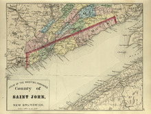
County of St. John, New Brunswick
Description: The map shows the county of St. John in New Brunswick. Shown are harbours, coves, rivers, railroads, towns, and cities. Atlas of the Maritime Provinces of the Dominion of Canada with historical and… more
Type: geographical maps
Date Issued (Source): 1878
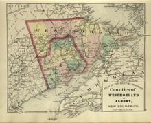
Counties of Westmoreland and Albert: New Brunswick
Description: The map shows the counties of Westmoreland and Albert in New Brunswick. Shown are bays, Cumberland basin. railroads and stations, roads, cities and towns.
Province: New Brunswick
Type: geological maps
Date Issued (Source): 1878
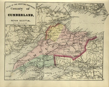
County of Cumberland: Nova Scotia
Description: The map shows the county of Cumberland in Nova Scotia. Shown are bays, channels, basins, mountains, rivers, railroads and stations, lakes, cities and towns.
Province: Nova Scotia
Type: geological maps
Date Issued (Source): 1878
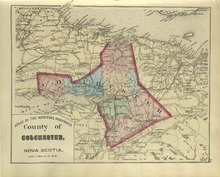
County of Colchester: Nova Scotia
Description: The map shows the county of Colchester in Nova Scotia. Shown are railroads and stations, basins, rivers, mountains, cities and towns.
Province: Nova Scotia
Type: geological maps
Date Issued (Source): 1878
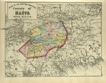
County of Hants: Nova Scotia
Description: The map shows the county of Hants in Nova Scotia. Shown are basins, lakes, gold mines, railroads, stations, and rivers.
Province: Nova Scotia
Type: geological maps
Date Issued (Source): 1878
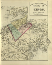
County of Kings: Nova Scotia
Description: The map shows the county of Kings in Nova Scotia. Shown are bays, brooks, creeks, lakes, railroads and stations, mines, roads, cities and towns.
Province: Nova Scotia
Type: geological maps
Date Issued (Source): 1878
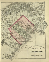
County of Lunenburg: Nova Scotia
Description: The map shows the county of Lunenburg in Nova Scotia. Shown are railroads abd stations, roads, rivers, bays, coves, basins, lakes, and harbours.
Province: Nova Scotia
Type: geological maps
Date Issued (Source): 1878
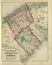
Coutnies of Annapolis and Queens : Nova Scotia
Description: The map shows the counties of Annapolis and Queens in Nova Scotia. Shown are rivers, roads, railroads, stations, lakes, harbours, cities, and towns.
Province: Nova Scotia
Type: geological maps
Date Issued (Source): 1878
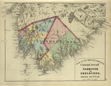
Counties of Yarmouth and Shelburne: Nova Scotia
Description: The map shows the counties of Yarmouth and Shelburne in Nova Scotia. Shown are railroads, stations, capes, coves, rivers, lakes, and harbours.
Province: Nova Scotia
Type: geological maps
Date Issued (Source): 1878
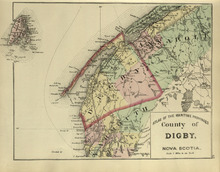
County of Digby: Nova Scotia
Description: The map shows the county of Digby in Nova Scotia. Shown are coves, rivers, capes, lakes, roads, railroads, bridges, cities and towns.
Province: Nova Scotia
Type: geological maps
Date Issued (Source): 1878
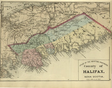
County of Halifax: Nova Scotia
Description: The map shows the county of Halifax in Nova Scotia. Shown are harbours, rivers, lakes, bays, gold mines, towns, and cities.
Province: Nova Scotia
Type: geological maps
Date Issued (Source): 1878
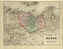
County of Pictou: Nova Scotia
Description: The map shows the county of Pictou in Nova Scotia. Shown are channel, rivers, lakes, harbours, railroads, lakes, mills, towns, and cities.
Province: Nova Scotia
Type: geological maps
Date Issued (Source): 1878
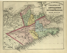
Couties of Antigonish and Guysborough: Nova Scotia
Description: The map shows the counties of Antigonish and Guysborough in Nova Scotia. Shown are rivers, bays, capes, lakes, points, roads, railroads, coves, harbours, cities, and towns.
Province: Nova Scotia
Type: geological maps
Date Issued (Source): 1878
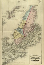
Counties of Inverness and Victoria: Nova Scotia
Description: The map shows the counties of Inverness and Victoria in Nova Scotia. Shown are bays, lakes, rivers, coves, gold mines, islands, harbours, cities, and towns.
Province: Nova Scotia
Type: geological maps
Date Issued (Source): 1878
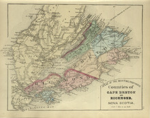
Counties of Cape Breton and Richmond: Nova Scotia>
Description: The map shows the counties of Cape Breton and Richmond in Nova Scotia. Shown are bays, lakes, points, channels, harbours, roads, railroads, towns, and cities.
Province: Nova Scotia
Type: geological maps
Date Issued (Source): 1878