Displaying 1 - 108 of 118
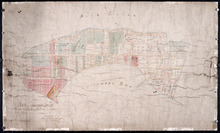
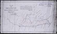
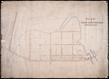
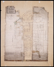
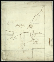
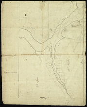
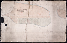
Plan of Cascumpec Point As sold by Public Auction in June 1871
Description: Plan of Cascumpec Point, as sold by public auction, June, 1871. The map shows lots, residents, bodies of water such as bays, cities and towns, and roads.
Province: Prince Edward Island
Type: cadastral maps
Date Created: 1871-08

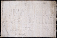
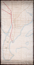
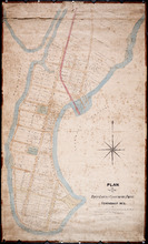
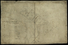
Plan of that portion of the town of Summerside laid off on the front of the farm by Mr. Jesse Green.
Description: Plan of that portion of the town of Summerside laid off on the front of the farm by Mr. Jesse Green. The map shows lots, residents, towns, cities, roads, and bodies of water.
Province: Prince Edward Island
Type: cadastral maps
Date Created: 1868-11-25
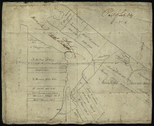
A Plan of the Property of Capt. Simon and Alexander Cheverie: in Souris East
Description: A plan of the property of Capt. Simon and Alexander Cheverie in Souris East. The map shows lots, acreage, roads/streets, and buildings.
Province: Prince Edward Island
Type: cadastral maps
Date Created: 1879-06-18

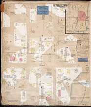
Plan of George Town: The Town Lots are 84 by 120 Feet. The North and South Streets are 100 Feet.…
Description: Plan of Georgetown showing lots and streets, bays, ranges, squares, and a school house. Also shows location of school house. Copy from the Office Plan No.6.
Province: Prince Edward Island
Date Created: 1853-06-07
Plan Shewing Lands in the Town, Common, and Royalty of Georgetown appropriated for Railway purposes…
Description: Plan showing lands in the Town, Common, and Royalty of Georgetown appropriated for Railway Purposes. The map shows residents, acreage, roads, and harbours.
Province: Prince Edward Island
Type: cadastral maps
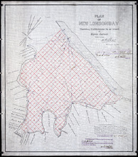
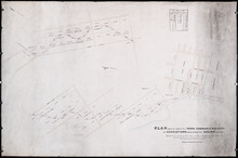
Plan of New London Bay: Showing Sub-divisions to be leased for Oyster Culture
Description: Plan of New London Bay showing sub-divisions to be leased for Oyster Culture. (No.9) The map shows residents, lots, measurements, and sand hills.
Province: Prince Edward Island
Type: cadastral maps
Date Created: 1914
Plan of Indian River: showing subdivisions to be leased for Oyster Culture
Description: Plan of Indian River showing subdivisions to be leased for Oyster Culture. (No.12). The map shows lots, and residents namesm along with measurements of the lots to be leased. Also shown is a… more
Province: Prince Edward Island
Type: cadastral maps
Date Created: 1914
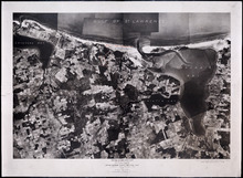
Prince Edward Island National Park: Covehead - Tracadie Section 1937
Description: Prince Edward Island National Park. Covehead - Tracadie section. Lots 34 and 35. Aerial photograph. Department of Mines and Resources, Mines and Geology Branch. Bureau of Geology and Topography. The… more
Province: Prince Edward Island
Type: cadastral maps, aerial photographs
Date Created: 1937
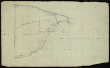
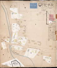
Unfinished plan of Alberton and Cascumpec Point, Lots 4 and 5
Description: Unfinished plan of Alberton and Cascumpec Point, Lots 4 and 5. Mainly outline. Shows churches, station ground, school, and the names of a few residents.
Province: Prince Edward Island
Type: cadastral maps
P.E.I. Railway: Elmira Branch Plan of Right-of-Way
Description: Prince Edward Island Railway. Elmira Branch. Plan of Right-of-Way (No.429, Kings Co.). Plan created by Wm. B. MacKenzie, Chief Engineer. The map shows lots, roads, residents, and acreage.
Province: Prince Edward Island
Type: cadastral maps
Date Created: 1909-06-02
Railway appropriations from Hunter River to Clyde Station: Lots 22 and 23
Description: Railway appropriations from Hunter River to Clyde Station. Lots 22 and 23. The map shows residents and acreage, roads, stations, ponds, and foliage.
Province: Prince Edward Island
Type: cadastral maps
Date Created: 1872
Plan-showing the Right of Way : Cape Traverse Branch P.E.I
Description: Plan showing the right of way of the Cape Traverse Branch of the Prince Edward Island Railway. The map shows roads, residents and acreage.
Province: Prince Edward Island
Type: cadastral maps

Map of Southport and Rosebank, Prince Edward Island: Drawn by C.D. Lambown Sept. 26, 1953
Description: Map of Southport and Rosebank, Lot.48. Shows names of residents, acreage, cities and towns, and Hillsborough River.
Province: Prince Edward Island
Type: cadastral maps
Date Created: 1953-09-26

Geological Map of Canada and Newfoundland: Derive from the Results of The Canadian Geological…
Description: Framed map of Canada and Newfoundland. The map is has colours for different land marks, and a table that explains it all. Shown are bodies of water such as rivers, islands, roads, towns, and cities.
Province: Newfoundland, New Brunswick, Prince Edward Island, Nova Scotia, Quebec
Type: geological maps
Date Created: 1866 (year uncertain)

Lot 43: No. 1
Description: Plan of Lot 43 (No.1), showing Bay Fortune, Rollo Bay and North Shore areas.
Province: Prince Edward Island
Type: cadastral maps
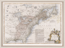
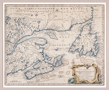
A Map of the British and French Settlements in North America
Description: Framed map; presenting French territories as far south as the mouth of the Mississippi. The map shows bodies of water such as, the Hudson's Bay, the Great Lakes, Northren mountains, fishing… more
Type: chorographic maps
Date Created: 1760 (year approximate)
A New and Accurate Map of the Islands of Newfoundland, Cape Briton, St. John and Anticosta:…
Description: Map, showing the Maritime provinces; the vertical fold indicates that it originally appeared in a book or atlas; cartouche in bottom right corner. Port Joy is the only settlement named on Isle St.… more
Publisher: Astron Obervat
Province: Nova Scotia, Newfoundland, Cape Breton, St. John, Anticosta
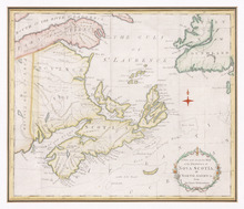
A New and Accurate Map of the Province of Nova Scotia, in North America, From the Latest…
Description: Framed map of the province of Nova Scotia and vicinity. The map shows bodies of water such as the Gulf of St. Lawrence and Bay of Fundy, towns, cities, villages, islands, banks, and a compass rose.
Province: Nova Scotia
Type: topographic maps, pictorial maps
Date Created: 1773

L'ACADIE: Par le Sr. Robert de Vaugindy Fils de Mr. Robert Geogr. ord, du Roy, Avec Privilege
Description: Period designation 18th century. The map shows bodies of water such as Baye Francoise, villages, towns, cities, mountains, trees, islands, and banks.
Province: Nova Scotia, Prince Edward Island
Type: topographic maps
Date Created: Unknown year in the century of the 1700s

Carta Geographica Del Canada Nell' America Settentrionale
Description: Framed map of Canada; cartouche top left corner: natives by a pond with deer and animals which are part dog, part fish. The map shows bodies of water such as Baja D' Hudson, villages, towns, and… more
Type: chorographic maps
Date Created: 1700 to 1799

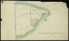
Plan of Town Lots at Cascumpec Point. Township No. 5.: Compiled and corrected from Surveys by John…
Description: Plan of Town Lots at Cascumpec Point, Lot 5. The map shows Cascumpec Point divided into parcels of land (most of them numbered) with names of residents. Shows land belonging to J. C. Pope outlined in… more
Province: Prince Edward Island
Type: cadastral maps
Date Created: 1877-08-01

Plan of Cascumpec Point Copied from a Plan in the Public Lands Departt. furnished by John Ball. L.…
Description: Plan of Cascumpec Point, Lot 5. The map shows numbered parcels of land on Cascumpec Point with names of residents and some land conveyance references. The legend indicates that parcels are outlined… more
Province: Prince Edward Island
Type: cadastral maps
Date Created: 1885-06
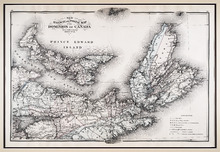
New Railway and Postal Map of the Dominion of Canada, Sheet No. 2
Description: Framed map shows the post offices, money order offices, P.O. saving offices, telegraph sections, ports of entry, railways and the distance between towns over post roads of the time. Prince Edward… more
Province: Prince Edward Island
Type: geological maps
Date Created: 1880
Plan of Pierce Gaul's Estate Montague-Bridge
Description: Plan of Pierce Gaul's Estate, Montague Bridge, Lot No.52. The map shows the Montague River, streets, and buildings. more
Province: Prince Edward Island
Type: cadastral maps
Date Created: 1877-05

Plan of certain tracts of land at or near Orwell according to registered deeds, and two surveys…
Description: Plan of part of Lot 50. Clark's Corner, Orwell. Shows certain tracts of land at or near Orwell according to registered deeds and two surveys. Rough copy included. more
Province: Prince Edward Island
Type: cadastral maps
Plan of Fort Augustus and Monaghan Settlement in Township Number 36, in Prince Edward Island, the…
Description: Plan of Fort Augustus and Monaghan Settlement in Lot 36, the property of the Rev. John McDonald. Shows names of residents and acreage, bodies of water such as rivers (Hillsborough), ponds, roads, and… more
Province: Prince Edward Island
Type: cadastral maps
Date Created: 1840
Plan of Town Lots at Cascumpec Point. Township No. 5.: Compiled and corrected from Surveys by John…
Description: Plan of Town Lots at Cascumpec Point, Lot 5. The map shows Cascumpec Point divided into parcels of land (most of them numbered) with names of residents. Shows land belonging to J. C. Pope outlined in… more
Province: Prince Edward Island
Type: cadastral maps
Date Created: 1877-08-01
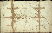
Entrance to the Croppo River
Description: Plan of part of Lot 29 (No.4). Entrance to Croppo River. Shows soundings at Crapaud Harbour. The map shows the harbour and entrance to the Crapaud (or Westmoreland) River. Soundings appear to be… more
Province: Prince Edward Island
Part of Lot 32
Description: Plan of part of Lot 32. North Milton area. The map shows the area around the intersection of the New Glasgow and Rustico roads in the northern part of Lot 32. The land is divided into parcels with… more
Province: Prince Edward Island
Type: cadastral maps
Part of Lot 33: Area around Rustico Bay
Description: Plan of part of Lot 33. Area around Rustico Bay. The map shows the area around Rustico Bay in the northwest part of Lot 33. It shows the land divided into parcels with names of some residents and… more
Province: Prince Edward Island
Type: cadastral maps
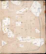
Part of Lot 34
Description: Plan of part of Lot 34 (No.3). Area around Covehead Bay. The map shows the northwestern portion of Lot 34, divided into parcels of land with the names of residents and/or proprietors and their… more
Province: Prince Edward Island
Type: cadastral maps
Part of Lot 34
Description: Plan of part of Lot 34 (No.6). Area around Covehead Bay. The map shows the northwestern portion of Lot 34 divided into parcels of land with the names of residents and/or proprietors and their acreage… more
Province: Prince Edward Island
Type: cadastral maps
A Draugth of the new road opened by order of his Excellency Governor Smith, for the west settlement…
Description: Plan of part of Lot 34 (No.41). This plan shows a new road in the Covehead area in the northwest corner of Lot 34. It describes the land surrounding the road with labels noting swamp or hardwood… more
Province: Prince Edward Island
Type: engineering maps
Date Created: 1824
Lot 37 - No. 12
Description: Plan of part of Lot 37 (No. 12). The Pisquid or Hill River area. Outline. The map shows the area where the Pisquid (or Hill) River joins the Hillsborough River in Lot 37. It gives the names of some… more
Province: Prince Edward Island
Type: cadastral maps, topographic maps
Part of Lot 38
Description: Plan of part of Lot 38 (No. 8). Coffin property. 220 acres of land bordering on Savage Harbour. The map shows the northwestern-most part of Lot 38 that is separated from the rest of the lot by Savage… more
Province: Prince Edward Island
Type: cadastral maps
Part of Lot No. 38
Description: Plan of part of Lot 38 (No. 8), Coffin property. 220 acres of land bordering on Savage Harbour. The map shows the northwestern-most part of Lot 38 that is separated from the rest of the lot by Savage… more
Province: Prince Edward Island
Type: cadastral maps
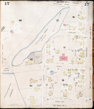
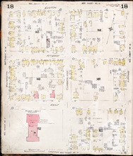
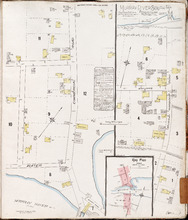
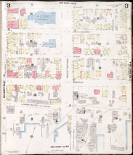
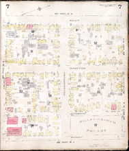
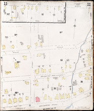
Charlottetown, P.E.I.: July, 1903
Description: This is Page 17 of 20 pages of fire insurance maps of Charlottetown. It was created in 1903 and revised to either 1910 or 1917. It shows an area bounded by Brighton Road and Euston Street to the… more
Publisher: Chas. E. Goad, Civil Engineer
Province: Prince Edward Island
Type: fire insurance maps
Date Created: 1903-07
Date Modified: 1910-08, 1917-07 (year and month uncertain)
Date Issued (Source): 1888
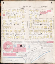
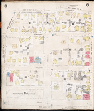
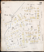
Charlottetown P.E.I.: July, 1903.
Description: This is Page 18 of 20 pages of fire insurance maps of Charlottetown. It was created in 1903 and revised to either 1910 or 1917. It shows the area from Euston Street to Grafton Street, between… more
Publisher: Chas. E. Goad, Civil Engineer
Province: Prince Edward Island
Type: fire insurance maps
Date Created: 1903-07
Date Modified: 1910-08, 1917-07 (year and month uncertain)
Date Issued (Source): 1888
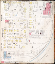
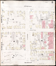
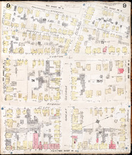
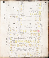
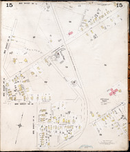
Charlottetown P.E.I.: July 1903
Description: This is Page 19 of 20 pages of fire insurance maps of Charlottetown. It was created in 1903 and revised to either 1910 or 1917. It shows the area from Grafton Street to Water Street, between Weymouth… more
Publisher: Chas. E. Goad, Civil Engineer
Province: Prince Edward Island
Type: fire insurance maps
Date Created: 1903-07
Date Modified: 1910-08, 1917-07 (year and month uncertain)
Date Issued (Source): 1888
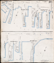
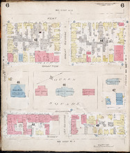
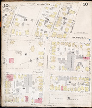
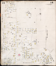
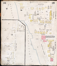
Charlottetown P.E.I.: July 1917. Reprinted.
Description: This is Page 20 of 20 pages of fire insurance maps of Charlottetown. It shows Water Street in two (2) sections that are intended to be continuous. The section at the top of the page shows Water… more
Publisher: Chas. E. Goad, Civil Engineer
Province: Prince Edward Island
Type: fire insurance maps
Date Created: 1917-07
Date Issued (Source): 1888
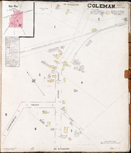
Coleman. P.E.I. Prince Co.: Population. 180. No Protection. Oct 1910.
Description: This is a fire insurance plan of the community of Coleman. It shows the Brae Road in the vicinity of Campbell Road and the P.E.I. Railway. A key plan in the upper left corner provides context. The… more
Publisher: Chas. E. Goad, Civil Engineer
Province: Prince Edward Island
Type: fire insurance maps
Date Created: 1910-10
Date Issued (Source): 1888
Crapaud P.E.I.: Population 300. No Appliances. Novr. 1897.
Description: This is a fire insurance plan of the village of Crapaud. It was created in 1897 and revised to 1910. The main map shows Main Street and the area where the roads into town converge. The Crapaud… more
Publisher: Chas. E. Goad, Civil Engineer
Province: Prince Edward Island
Type: fire insurance maps
Date Created: 1897-11
Date Modified: 1910-10
Date Issued (Source): 1888
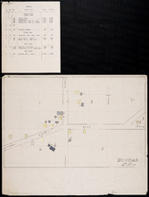
Dundas, Lot 55
Description: This item consists of a fire insurance plan of the community of Dundas and an accompanying typewritten text document. The map shows the Dundas Road and the buildings in the area. It divides the… more
Province: Prince Edward Island
Type: fire insurance maps
Date Issued (Source): 1888
Georgetown P.E.I.
Description: This is the first of two pages of fire insurance maps of Georgetown. It was created in 1888, revised to 1897, and revised again to 1910. This page concentrates on an area one and a half blocks west… more
Publisher: Chas. E. Goad, Civil Engineer
Province: Prince Edward Island
Type: fire insurance maps
Date Created: 1888-10
Date Modified: 1897-11, 1910-09
Date Issued (Source): 1888
Georgetown P.E.I.: Oct. 1893
Description: This is the second of two (2) pages of fire insurance maps of Georgetown. It was created in 1893 and revised to 1910. The map concentrates on an area one and a half blocks east from West Street,… more
Publisher: Chas. E. Goad, Civil Engineer
Province: Prince Edward Island
Type: fire insurance maps
Date Created: 1893-10
Date Modified: 1910-09
Date Issued (Source): 1888
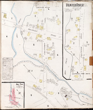
Hunter River P.E.I. Kings Co.: Population 150. No Protection. Oct. 1910.
Description: This is a fire insurance plan of Hunter River. It shows the town in two (2) sections that are intended to be continuous. The sections show the area around the California Road and the Malpeque Raod. A… more
Publisher: Chas. E. Goad, Civil Engineer
Province: Prince Edward Island
Type: fire insurance maps
Date Created: 1910-10
Date Issued (Source): 1888

Kensington P.E.I.: Population 450. 1 Hand Engine, 100' hose. October 1888
Description: This is a fire insurance plan of the village of Kensington. It was created in 1888 and revised to 1910. It focuses on the area of Broadway Street, between Dufferin and Victoria streets, approximately… more
Publisher: Chas. E. Goad, Civil Engineer
Province: Prince Edward Island
Type: fire insurance maps
Date Created: 1888-10
Date Modified: 1910-09
Date Issued (Source): 1888
Miscouche, Lot 17
Description: This item consists of a fire insurance plan of the community of Miscouche and an accompanying handwritten text document. The map of Miscouche focuses on the area of the Fifteen Point Road. It shows… more
Province: Prince Edward Island
Type: fire insurance maps
Date Issued (Source): 1888
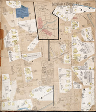
Montague Bridge P.E.I.
Description: This is a fire insurance plan of the village of Montague Bridge consisting of two (2) maps--one for each side of the Montague River. It was created in 1888 and revised to 1910. The map on the left… more
Publisher: Chas. E. Goad, Civil Engineer
Province: Prince Edward Island
Type: fire insurance maps
Date Created: 1888-10
Date Modified: 1910-09
Date Issued (Source): 1888
Mount Stewart Prince Edward Island: Population 400. No Appliances. October 1893.
Description: This is a fire insurance plan of the village of Mount Stewart consisting of two maps--one for each side of the Hillsborough River. It was created in 1893 and revised to 1910. The smaller map, on the… more
Publisher: Chas. E. Goad, Civil Engineer
Province: Prince Edward Island
Type: fire insurance maps
Date Created: 1893-10
Date Modified: 1910-09
Date Issued (Source): 1888
Murray Harbour South P.E.I., Kings Co.: Population 350. No Protection. Octr. 1910
Description: This is a fire insurance plan of the community of Murray Harbour South that consists of two maps--one for each side of the South River. The smaller map, on the left side of the page, shows an area of… more
Publisher: Chas. E. Goad, Civil Engineer
Province: Prince Edward Island
Type: fire insurance maps
Date Created: 1910-10
Date Issued (Source): 1888
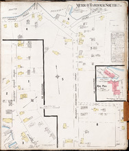
O'Leary P.E.I., Prince Co.: Population 350. No Protection. Oct. 1910
Description: This is a fire insurance plan of O'Leary. It shows the town in two (2) sections that are intended to be continuous. The sections show the area of the O'Leary Road between the Barckley (… more
Publisher: Chas. E. Goad, Civil Engineer
Province: Prince Edward Island
Type: fire insurance maps
Date Created: 1910-10
Date Issued (Source): 1888
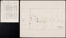
Pownal, Lot 49
Description: This item consists of a fire insurance plan of the community of Pownal and an accompanying typewritten text document. The map shows Pownal divided into numbered sections. It shows buildings and their… more
Province: Prince Edward Island
Type: fire insurance maps
Date Issued (Source): 1888
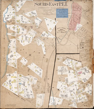
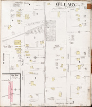
Souris East P.E.I.: Population 3,000. No appliances. Chas E Goad C. E. Montreal. October 1888
Description: This is a fire insurance plan of Souris East showing the the town in two (2) sections that are intended to be continuous. It was created in 1888 and revised to 1910. The map shows the area… more
Publisher: Chas. E. Goad, Civil Engineer
Province: Prince Edward Island
Type: fire insurance maps
Date Created: 1888-10
Date Modified: 1910-09
Date Issued (Source): 1888
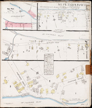
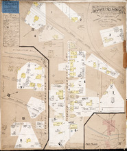
St. Peters Bay P.E.I., Kings Co.: Population 250. No Protection. Octr. 1910
Description: This is a fire insurance plan of the community of St. Peter's Bay that consists of three (3) parts: two maps, one of which is shown in two sections that are meant to be continuous. The largest… more
Publisher: Chas. E. Goad, Civil Engineer
Province: Prince Edward Island
Type: fire insurance maps
Date Created: 1910-10
Date Issued (Source): 1888

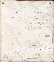
Summerside Prince Edward Island: Population: 3,500. July 1903
Description: This item, the first of 11 pages of fire insurance maps of Summerside, serves as the key plan for the other Summerside pages. It was created in 1903, revised to 1910, and then revised again to August… more
Publisher: Chas. E. Goad, Civil Engineer
Province: Prince Edward Island
Type: fire insurance maps
Date Created: 1903-07
Date Modified: 1910-10, 1917-08
Date Issued (Source): 1888

Summerside P.E.I.: Aug. 1917. Reprinted.
Description: This is Page 2 of 11 pages of fire insurance maps of Summerside. It shows the area from Market Street North to the waterfront, between Duke and Central streets. The map shows numbered town blocks and… more
Publisher: Chas. E. Goad, Civil Engineer
Province: Prince Edward Island
Type: fire insurance maps
Date Created: 1917-08
Date Issued (Source): 1888

Summerside, P.E.I.: Oct. 1910. Reprinted
Description: This is the older (1910) version of Page 3 of the Summerside fire insurance maps. The updated map of this town section is shown on Summerside_p3_1917. This map shows the area from Church Street to… more
Publisher: Chas. E. Goad, Civil Engineer
Province: Prince Edward Island
Type: fire insurance maps
Date Created: 1910-10
Date Issued (Source): 1888

Summerside P.E.I.: Aug 1917. Reprinted
Description: This is Page 3 of 11 pages of fire insurance maps of Summerside. This map shows the area from Church Street to the waterfront, between Central and Granville streets. The map shows numbered town… more
Publisher: Chas. E. Goad, Civil Engineer
Province: Prince Edward Island
Type: fire insurance maps
Date Created: 1917-08
Date Issued (Source): 1888

Summerside P.E.I.: July 1903.
Description: This is the older (1903, updated to 1910) version of Page 4 of the Summerside fire insurance maps. A more updated map of this town section is shown on Summerside_p4_1917. This map shows the area from… more
Publisher: Chas. E. Goad, Civil Engineer
Province: Prince Edward Island
Type: fire insurance maps
Date Created: 1903-07
Date Modified: 1910
Date Issued (Source): 1888

Summerside, P.E.I.: Aug. 1917. Reprinted
Description: This is Page 4 of 11 pages of fire insurance maps of Summerside. (An older version of this town section is shown on Summerside_p4_1910.) The map shows the area from Belmont Street to the waterfront,… more
Publisher: Chas. E. Goad, Civil Engineer
Province: Prince Edward Island
Type: fire insurance maps
Date Created: 1917-08
Date Issued (Source): 1888
Summerside, P.E.I.: July 1903
Description: This is Page 5 of 11 pages of fire insurance maps of Summerside. It was created in 1903 and revised to 1910. It shows the area from Myrtle Street to Market Street North, between Duke and Central… more
Publisher: Chas. E. Goad, Civil Engineer
Province: Prince Edward Island
Type: fire insurance maps
Date Created: 1903-07
Date Modified: 1910
Date Issued (Source): 1888
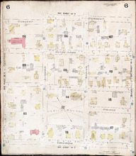
Summerside P.E.I.: July 1903.
Description: This is Page 6 of 11 pages of fire insurance maps of Summerside. It was created in 1903 and revised to 1910. It shows the area from Convent Street to Church Street, between Central and Granville… more
Publisher: Chas. E. Goad, Civil Engineer
Province: Prince Edward Island
Type: fire insurance maps
Date Created: 1903-07
Date Modified: 1910
Date Issued (Source): 1888
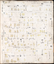
Summerside P.E.I.: July 1903.
Description: This is Page 7 of 11 pages of fire insurance maps of Summerside. It was created in 1903 and revised to 1910. It shows the area from Carvell Street to Belmont Street, between Granville and Russell… more
Publisher: Chas. E. Goad, Civil Engineer
Province: Prince Edward Island
Type: fire insurance maps
Date Created: 1903-07
Date Modified: 1910
Date Issued (Source): 1888
Summerside, P.E.I.: July 1903
Description: This is Page 8 of 11 pages of fire insurance maps of Summerside. It was created in 1903 and revised to 1917. It shows an area from the Kirk Street vicinity to the waterfront, east of Russell Street.… more
Publisher: Chas. E. Goad, Civil Engineer
Province: Prince Edward Island
Type: fire insurance maps
Date Created: 1903-07
Date Modified: 1917-08 (year and month uncertain)
Date Issued (Source): 1888
Summerside, P.E.I.: July 1903
Description: This is Page 9 of 11 pages of fire insurance maps of Summerside. It was created in 1903 and revised to either 1910 or 1917. It shows the area from Chestnut Avenue, in the north, to Myrtle and Convent… more
Publisher: Chas. E. Goad, Civil Engineer
Province: Prince Edward Island
Type: fire insurance maps
Date Created: 1903-07
Date Modified: 1910 (year uncertain)
Date Issued (Source): 1888
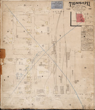
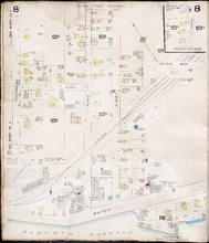
Tignish. P.E.I.: Population 500. No appliances. October 1888
Description: This is an older (1888, revised to 1893) version of a fire insurance plan of the village of Tignish. A more updated plan is shown on the map Tignish_1910. The map shows the area near Chapel Road and… more
Publisher: Chas. E. Goad, Civil Engineer
Province: Prince Edward Island
Type: fire insurance maps
Date Created: 1888-10
Date Modified: 1893-10
Date Issued (Source): 1888
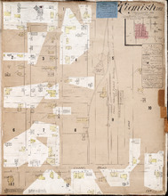
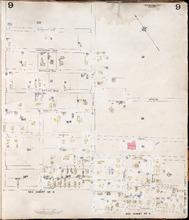
Tignish P.E.I.: Population: 500. Hook & Ladder. Nov 1897.
Description: This is a fire insurance plan of the village of Tignish. It was created in 1897 and revised to 1910. (An older plan is shown on the map Tignish_1893.) The map shows the area near Chapel Road and the… more
Publisher: Chas. E. Goad, Civil Engineer
Province: Prince Edward Island
Type: fire insurance maps
Date Created: 1897-11
Date Modified: 1910-10
Date Issued (Source): 1888
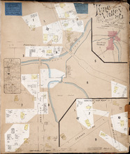
Tyne Valley P.E.I.: Novr. 1897. 1 Mile West of Port Hill Station. Population 300. No Appliances.…
Description: This is a fire insurance plan of Tyne Valley. It was created in 1897, revised to 1903, and then revised again to October, 1910. It shows the town in two (2) sections that are intended to be… more
Publisher: Chas. E. Goad, Civil Engineer
Province: Prince Edward Island
Type: fire insurance maps
Date Created: 1897-11
Date Modified: 1903-07, 1910-10
Date Issued (Source): 1888
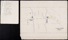
Vernon River Bridge, Lot 50
Description: This item consists of a fire insurance plan of the community of Vernon River Bridge and an accompanying handwritten text document. The map of Vernon River shows the community divided into numbered… more
Province: Prince Edward Island
Type: fire insurance maps
Date Issued (Source): 1888
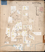
Victoria P.E.I.: Population 300. No appliances. Chas E Goad Civil Engineer Toronto & Montreal.…
Description: This is a fire insurance plan of the village of Victoria. It was created in 1893 and revised to October, 1910. It shows the area from Bardin Street to the waterfront, between Nelson and Russell… more
Publisher: Chas. E. Goad, Civil Engineer
Province: Prince Edward Island
Type: fire insurance maps
Date Created: 1893-10
Date Modified: 1910-10
Date Issued (Source): 1888
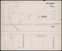
Wellington, Lot 16
Description: This item is a fire insurance plan of the community of Wellington. It shows the village in three (3) sections that are intended to be continuous. The largest map section, across the top of the sheet… more
Province: Prince Edward Island
Type: fire insurance maps
Date Issued (Source): 1888
Murray River South P.E.I., Kings Co.: Population 300. No Protection. Oct 1910
Description: This is a fire insurance plan of the community of Murray River South that consists of two maps--one for each side of the Murray River. The larger map, on the left side of the page, shows an area of… more
Publisher: Chas. E. Goad, Civil Engineer
Province: Prince Edward Island
Type: fire insurance maps
Date Created: 1910-10
Date Issued (Source): 1888

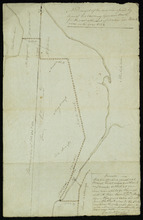
Plan of Lot 23
Description: Plan of Lot 23. Shows names of residents in central portion of Lot, i.e. around Clyde River.
Province: Prince Edward Island
Type: cadastral maps
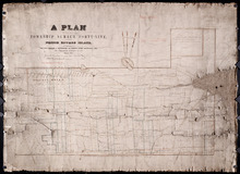
Plan of that part of Township Number Forty-nine, in Prince Edward Island, the Property of the Hon.…
Description: Plan of part of Lot 49, the property of the Hon. Edward C. Haythorne and Robert Poore Haythorne. Tracts shaded green sold with the Act 28 Vic. Cap.5. (No.133). Shows names of residents and acreage,… more
Province: Prince Edward Island
Type: cadastral maps
Date Created: 1857-01
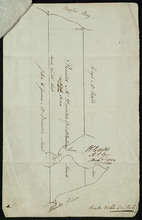
A Plan of Ronald McDonalds Land of Grand Tracadie For The Surveyors Generals Office
Description: Plan of part of Lot 35 (No. 5). The map shows 175 acres of land belonging to Ronald McDonald at Grand Tracadie in the northern part of Lot 35. The map shows the names of the residents on either side… more
Province: Prince Edward Island
Type: cadastral maps
Date Created: 1824-08-03
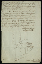
Plan Shewing the situation of the respective Fishing Establishments, Fronting Harris or Rustico Bay…
Description: Plan of part of Lot 24. Shows situation of the fishing establishments fronting Harris or Rustico Bay. From actual survey. The map shows the Harbours Mouth and Robinsons Island.
Province: Prince Edward Island
Type: cadastral maps
Date Created: 1869-09-02

Alberton, Prince Edward Island: Population 1500. Hand Engine. 400' Hose. Water Supply: Brook…
Description: This is a fire insurance plan of the town of Alberton concentrating on two blocks of Main Street from Church Street to Argyle Street. A key plan in the lower left corner provides context. The map was… more
Publisher: Chas. E. Goad, Civil Engineer
Province: Prince Edward Island
Type: fire insurance maps
Date Created: 1888-10
Date Modified: 1910-10
Date Issued (Source): 1888

Annandale, Lot 65
Description: This item may be a draft of a fire insurance plan of the community of Annandale. The map, drawn on a grid, in pencil, shows the area of Main Street and Lorne Street. It shows buildings, but they are… more
Province: Prince Edward Island
Type: fire insurance maps
Date Created: 1845
Date Issued (Source): 1888
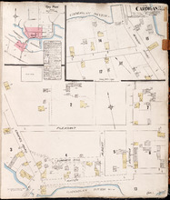
Cardigan P.E.I., Kings Co.: Population 300. No Protection. Oct. 1910
Description: This is a fire insurance plan of the village of Cardigan consisting of two maps--one for each side of the Cardigan River. A key plan in the upper left corner provides context. The map on the upper… more
Publisher: Chas. E. Goad, Civil Engineer
Province: Prince Edward Island
Type: fire insurance maps
Date Created: 1910-10
Date Issued (Source): 1888
Date Modified (Source): 1910-10, 1917-10
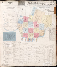
Charlottetown Prince Edward Island: Population: 12,500. July 1903
Description: This item, the first of 20 pages of fire insurance maps of Charlottetown, serves as the key plan for the other Charlottetown pages. It was created in 1903, revised to 1910 and revised again to 1917.… more
Publisher: Chas. E. Goad, Civil Engineer
Province: Prince Edward Island
Type: fire insurance maps
Date Created: 1903-07
Date Modified: 1910-08, 1917-07
Date Issued (Source): 1888
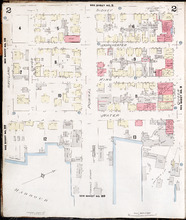
Charlottetown, Prince Edward Island: July 1917. Reprinted
Description: This is Page 2 of 20 pages of fire insurance maps of Charlottetown. It shows the area from Sidney Street to the waterfront, between Haviland and Queen streets. The map shows numbered city blocks and… more
Publisher: Chas. E. Goad, Civil Engineer
Province: Prince Edward Island
Type: fire insurance maps
Date Created: 1917-07
Date Issued (Source): 1888
Charlottetown, Prince Edward Island: July 1917. Reprinted
Description: This is Page 3 of 20 pages of fire insurance maps of Charlottetown. It shows the area from Sidney Street to the waterfront, between Queen and Prince streets. The map shows numbered city blocks and… more
Publisher: Chas. E. Goad, Civil Engineer
Province: Prince Edward Island
Type: fire insurance maps
Date Created: 1917-07
Date Issued (Source): 1888
Charlottetown, P.E.I.: July 1903
Description: This is Page 4 of 20 pages of fire insurance maps of Charlottetown. It was created in 1903 and revised to either 1910 or 1917. The map shows the area from Sidney Street to the waterfront, between… more
Publisher: Chas. E. Goad, Civil Engineer
Province: Prince Edward Island
Type: fire insurance maps
Date Created: 1903-07
Date Modified: 1910-08, 1917-07 (year and month uncertain)
Date Issued (Source): 1888
Charlottetown, P.E.I.: July 1917. Reprinted
Description: This is Page 5 of 20 pages of fire insurance maps of Charlottetown. It shows the area from Kent Street to Sidney Street, between Rochford and Queen streets. The map shows numbered city blocks and the… more
Publisher: Chas. E. Goad, Civil Engineer
Province: Prince Edward Island
Type: fire insurance maps
Date Created: 1917-07
Date Issued (Source): 1888
Charlottetown, P.E.I.: July 1903.
Description: This is Page 6 of 20 pages of fire insurance maps of Charlottetown. It was created in 1903 and revised to either 1910 or 1917. The map shows the area from Kent Street to Sidney Street, between Queen… more
Publisher: Chas. E. Goad, Civil Engineer
Province: Prince Edward Island
Type: fire insurance maps
Date Created: 1903-07
Date Modified: 1910-08, 1917-07 (year and month uncertain)
Date Issued (Source): 1888
Charlottetown, P.E.I.: July 1903.
Description: This is Page 7 of 20 pages of fire insurance maps of Charlottetown. It was created in 1903 and revised to either 1910 or 1917. The map shows the area from Kent Street to Sidney Street, between Prince… more
Publisher: Chas. E. Goad, Civil Engineer
Province: Prince Edward Island
Type: fire insurance maps
Date Created: 1903-07
Date Modified: 1910-08, 1917-07 (year and month uncertain)
Date Issued (Source): 1888
Charlottetown, P.E.I.: July 1903
Description: This is Page 8 of 20 pages of fire insurance maps of Charlottetown. It was created in 1903 and revised to either 1910 or 1917. It shows the area from Churchill Avenue and Chestnut Street to Kent… more
Publisher: Chas. E. Goad, Civil Engineer
Province: Prince Edward Island
Type: fire insurance maps
Date Created: 1903-07
Date Modified: 1910-08, 1917-07 (year and month uncertain)
Date Issued (Source): 1888
Charlottetown, P.E.I.: July 1903.
Description: This is Page 9 of 20 pages of fire insurance maps of Charlottetown. It was created in 1903 and revised to either 1910 or 1917. It shows the area from Passmore Street to Kent Street, between Queen and… more
Publisher: Chas. E. Goad, Civil Engineer
Province: Prince Edward Island
Type: fire insurance maps
Date Created: 1903-07
Date Modified: 1910-08, 1917-07 (year and month uncertain)
Date Issued (Source): 1888
Charlottetown P.E.I.: July 1903
Description: This is Page 10 of 20 pages of fire insurance maps of Charlottetown. It was created in 1903 and revised to either 1910 or 1917. It shows the area from just north of Euston Street, south to Kent… more
Publisher: Chas. E. Goad, Civil Engineer
Province: Prince Edward Island
Type: fire insurance maps
Date Created: 1903-07
Date Modified: 1910-08, 1917-07 (year and month uncertain)
Date Issued (Source): 1888
Charlottetown P.E.I.: July 1917. Reprinted
Description: This item, Page 11 of 20 pages of fire insurance plans of Charlottetown, consists of two (2) maps. The main map shows the area from Green Street to Brighton Road, between Greenfield Avenue (Second)… more
Publisher: Chas. E. Goad, Civil Engineer
Province: Prince Edward Island
Type: fire insurance maps
Date Created: 1917-07
Date Issued (Source): 1888
Charlottetown P.E.I.: July, 1903.
Description: This is Page 12 of 20 pages of fire insurance maps of Charlottetown. It was created in 1903 and revised to either 1910 or 1917. It shows the area from Douglas Street to Churchill Avenue and Chestnut… more
Publisher: Chas. E. Goad, Civil Engineer
Province: Prince Edward Island
Type: fire insurance maps
Date Created: 1903-07
Date Modified: 1910-08, 1917-07 (year and month uncertain)
Date Issued (Source): 1888
Charlottetown P.E.I.: July, 1903.
Description: This is Page 13 of 20 pages of fire insurance maps of Charlottetown. It was created in 1903 and revised to either 1910 or 1917. It shows the area bounded by Connolly Street in the north, Elm Avenue/… more
Publisher: Chas. E. Goad, Civil Engineer
Province: Prince Edward Island
Type: fire insurance maps
Date Created: 1903-07
Date Modified: 1910-08, 1917-07 (year and month uncertain)
Date Issued (Source): 1888
Charlottetown P.E.I.: July, 1903.
Description: This is Page 14 of 20 pages of fire insurance maps of Charlottetown. It was created in 1903 and revised to either 1910 or 1917. It shows the area from Allan (Allen) Street, in the north, to (… more
Publisher: Chas. E. Goad, Civil Engineer
Province: Prince Edward Island
Type: fire insurance maps
Date Created: 1903-07
Date Modified: 1910-08, 1917-07 (year and month uncertain)
Date Issued (Source): 1888
Charlottetown, P.E.I.: July, 1903.
Description: This is Page 15 of 20 pages of fire insurance maps of Charlottetown. It was created in 1903 and revised to either 1910 or 1917. The map shows part of the eastern portion of early twentieth-century… more
Publisher: Chas. E. Goad, Civil Engineer
Province: Prince Edward Island
Type: fire insurance maps
Date Created: 1903-07
Date Modified: 1910-08, 1917-07 (year and month uncertain)
Date Issued (Source): 1888
Charlottetown P.E.I.: July 1903
Description: This is Page 16 of 20 pages of fire insurance maps of Charlottetown. It was created in 1903 and revised to either 1910 or 1917. It contains two (2) maps, showing two (2) different areas of the city.… more
Publisher: Chas. E. Goad, Civil Engineer
Province: Prince Edward Island
Type: fire insurance maps
Date Created: 1903-07
Date Modified: 1910-08, 1917-07 (year and month uncertain)
Date Issued (Source): 1888

Plan of Alberton: Surveyed by John Ball, Land Surveyor
Description: Plan of part of Alberton, Lot 4. Shows names of residents and land conveyance references, bodies of water such as bays, and creeks, and roads.
Province: Prince Edward Island
Type: cadastral maps
Date Created: 1871-08

Plan of Georgetown, Georgetown Common, and Georgetown Royalty
Description: Plan of Georgetown, Georgetown Common, and Georgetown Royalty. Shows lot numbers. Gives names of a few residents in the Royalty. Also gives nautical soundings for Albion Bay and Brudenell River.
Province: Prince Edward Island
Type: cadastral maps
Date Created: 1828
Map of Lot Forty-Eight: J.H. Meachams and Co. Atlas
Description: Map of Lot 48. Draft for Meacham's Atlas. Also includes inset map of Southport or Stratford (scale: 6 chains/inch). Shows the Charlottetown Royalty, bodies of water such as rivers, and lakes,… more
Province: Prince Edward Island
Type: cadastral maps

Plan of Murray River Lot 63: North of the River
Description: Plan of part of Murray River, Lot No.63. Area north of the River and west of Main Street. The map shows residents, lots, acreage, roads, towns, and a nautical compass.
Province: Prince Edward Island
Type: cadastral maps
Date Created: 1958

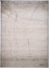
Plan showing the situation of the line of road from Melville Road to Appin Road also the connecting…
Description: Plan showing the situation of the line of road from Melville Road to Appin Road; also, the connecting road leading to Crapaud Wharf. Roads pass through Lots 29 and 30. (No.15, Queen's). Shown… more
Province: Prince Edward Island
Type: cadastral maps
Date Created: 1868-06-08
Profiles and plans of roads from Southport
Description: Profiles and plans of roads from Southport. (No.10) The map shows roads, lots, residents, and acreage.
Province: Prince Edward Island
Type: cadastral maps

A Plan of Land on Lot or Township No. 17 in Prince County, P. E. Island
Description: A plan of part of Lot 17, the property of J. Weatherbe, Summerside. (No.11). Shown are lots, residents, measurements and roads.
Province: Prince Edward Island
Type: cadastral maps
Date Created: 1857-06

Plan of A Tract of Land situate in Summerside P.E.Island, in the possesion of Mr. Jesse Green, laid…
Description: Plan of a tract of land situated in Summerside and laid off in pasture lots. The property of Mr. Jesse Green. The map shows lots, residents, roads, and acreage.
Province: Prince Edward Island
Type: cadastral maps
Date Created: 1877-04-24
Plan of part of Lot 28, showing the property of William Carruthers bordering on Borden Harbour.
Description: Plan of part of Lot 28, showing the property of William Carruthers bordering on Borden Harbour. The map shows lots, residents, water, and roads.
Province: Prince Edward Island
Type: cadastral maps
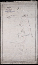
Plan of Shore and Land connected with The Beach Fishery Station Murray Harbour: The Property of Hon…
Description: Plan of part of Lot 64. The shore and land connected with the Beach Fishery Station, Murray Harbour. The property of the Hon. David Davies. The map shows lots, residents, bodies of water, and roads.
Province: Prince Edward Island
Type: cadastral maps
Date Created: 1872-10-29
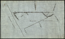
A Plan of Souris Beach
Description: Plan of part of Lots 44 and 45, Souris Beach. The map shows dry spots at low water, lots, and residents.
Province: Prince Edward Island
Type: cadastral maps
Date Created: 1866