Displaying 433 - 540 of 845
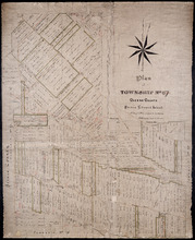
Plan Combining both Moieties of Township Number Twenty;: Copied from the Plans handed in by the…
Description: Plan of Lot 20 (No.52). Cunard and Cundall Estates. Copied from the plans handed in by the Proprietors (corrected where necessary by minor surveys, and chainage on leases) by Thos. MacKinlay. Shows… more
Province: Prince Edward Island
Type: cadastral maps

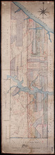
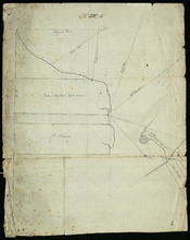
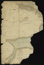
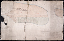
A Plan of Lot No. 61: By John Aldous from survey made in May & June 1842
Description: Plan of Lot 61 (No.162). Sullivan Estate. Landlord's plan. Shows names of residents and acreage. Signed by G.W. DeBlois. The map shows roads, bodies of water such as Sturgeon Bay and River,… more
Province: Prince Edward Island
Type: cadastral maps

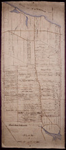
A Plan of the undisposed of Parts of Lot No. 60 in Queens County in Prince Edward Island by Rodk.…
Description: A plan of the undisposed parts of Lot 60. Code indicates tracts of land sold and tracts of land without lease. Shows names of residents and acreage. Surveyed by Rod'k Campbell. A nautical… more
Province: Prince Edward Island
Type: cadastral maps
Date Created: 1860
Plan of Lot or Township No. 60 Copied from the Survey of Roderick Campbell by Owen Curtis. L. S.…
Description: Plan of Lot 60 (No.161). Copied from the survey of Roderick Campbell by Owen Curtis, 1877. Shows names of residents, acreage, and land conveyance references. The map shows bodies of water such as… more
Province: Prince Edward Island
Type: cadastral maps
Date Created: 1877

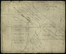
Plan of Lot 59 (No.156)
Description: Plan of Lot 59 (No.156). Montgomery Estate. Shows names, acreage, and land conveyance references for some residents, roads, and a nautical compass.
Province: Prince Edward Island
Type: cadastral maps

A Plan of the undisposed part of 1/3 of Lot No. 59 Kings County in Prince Edward Island belonging…
Description: A plan of the undisposed part of Lot 59 belonging to the Earl of Selkirk (No.158). Shows names of residents, acreage, and land conveyance references. Surveyed by Rod'k Campbell.The map shows… more
Province: Prince Edward Island
Type: cadastral maps
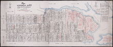
Plan of Township No. 59: Compiled from the proprietors plans, descriptions in leases and registered…
Description: Plan of Lot 59 compiled from the proprietors' plans, descriptions in leases and registered deeds, and from Meacham's Atlas with additions and corrections from surveys made at various times… more
Province: Prince Edward Island
Type: cadastral maps
Date Created: 1922-03
Plan of Township No. 58: Compiled from the proprietors plans and Meacham's Atlas, and from the…
Description: Plan of Lot 58 compiled from the proprietors' plans and Meacham's Atlas and from the descriptions in leases and registered deeds with additions and corrections from various surveys made… more
Province: Prince Edward Island
Type: cadastral maps
Date Created: 1916
Plan of Township No. 56: referred to in the annexed Deed shewing the situation of lands conveyed by…
Description: Plan of Lot 56 showing the situation of 18,028 acres of land conveyed by T. Heath Haviland and G.W. DeBlois to the Commissioner of Public Lands. The map shows Lot 56 divided into parcels of land with… more
Province: Prince Edward Island
Type: cadastral maps

A Plan of Township No. 56 in Kings County P. E. Island, the Property of Hon. T. H. Haviland of…
Description: Plan of Lot 56 (No.149). Property of Hon. T.H. Haviland of Charlottetown. Shows names of residents and acreage, bodies of water such as rivers, bays, creeks, ponds, roads, and a nautical compass.
Province: Prince Edward Island
Type: cadastral maps
Date Created: 1864
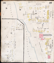
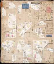
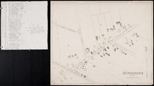
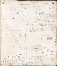
Charlottetown P.E.I.: July 1903
Description: This is Page 16 of 20 pages of fire insurance maps of Charlottetown. It was created in 1903 and revised to either 1910 or 1917. It contains two (2) maps, showing two (2) different areas of the city.… more
Publisher: Chas. E. Goad, Civil Engineer
Province: Prince Edward Island
Type: fire insurance maps
Date Created: 1903-07
Date Modified: 1910-08, 1917-07 (year and month uncertain)
Date Issued (Source): 1888
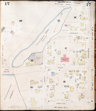
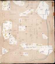
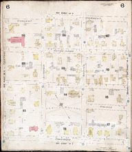
Charlottetown, P.E.I.: July, 1903
Description: This is Page 17 of 20 pages of fire insurance maps of Charlottetown. It was created in 1903 and revised to either 1910 or 1917. It shows an area bounded by Brighton Road and Euston Street to the… more
Publisher: Chas. E. Goad, Civil Engineer
Province: Prince Edward Island
Type: fire insurance maps
Date Created: 1903-07
Date Modified: 1910-08, 1917-07 (year and month uncertain)
Date Issued (Source): 1888
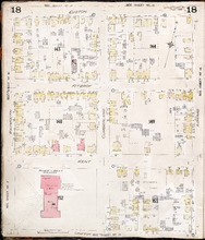
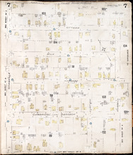
Charlottetown P.E.I.: July, 1903.
Description: This is Page 18 of 20 pages of fire insurance maps of Charlottetown. It was created in 1903 and revised to either 1910 or 1917. It shows the area from Euston Street to Grafton Street, between… more
Publisher: Chas. E. Goad, Civil Engineer
Province: Prince Edward Island
Type: fire insurance maps
Date Created: 1903-07
Date Modified: 1910-08, 1917-07 (year and month uncertain)
Date Issued (Source): 1888
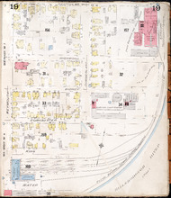
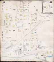
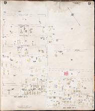
Charlottetown P.E.I.: July 1903
Description: This is Page 19 of 20 pages of fire insurance maps of Charlottetown. It was created in 1903 and revised to either 1910 or 1917. It shows the area from Grafton Street to Water Street, between Weymouth… more
Publisher: Chas. E. Goad, Civil Engineer
Province: Prince Edward Island
Type: fire insurance maps
Date Created: 1903-07
Date Modified: 1910-08, 1917-07 (year and month uncertain)
Date Issued (Source): 1888
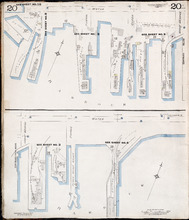
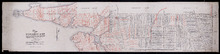
Charlottetown P.E.I.: July 1917. Reprinted.
Description: This is Page 20 of 20 pages of fire insurance maps of Charlottetown. It shows Water Street in two (2) sections that are intended to be continuous. The section at the top of the page shows Water… more
Publisher: Chas. E. Goad, Civil Engineer
Province: Prince Edward Island
Type: fire insurance maps
Date Created: 1917-07
Date Issued (Source): 1888
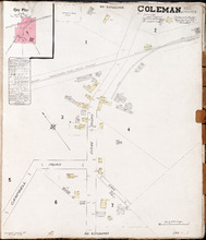
Coleman. P.E.I. Prince Co.: Population. 180. No Protection. Oct 1910.
Description: This is a fire insurance plan of the community of Coleman. It shows the Brae Road in the vicinity of Campbell Road and the P.E.I. Railway. A key plan in the upper left corner provides context. The… more
Publisher: Chas. E. Goad, Civil Engineer
Province: Prince Edward Island
Type: fire insurance maps
Date Created: 1910-10
Date Issued (Source): 1888
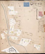
Crapaud P.E.I.: Population 300. No Appliances. Novr. 1897.
Description: This is a fire insurance plan of the village of Crapaud. It was created in 1897 and revised to 1910. The main map shows Main Street and the area where the roads into town converge. The Crapaud… more
Publisher: Chas. E. Goad, Civil Engineer
Province: Prince Edward Island
Type: fire insurance maps
Date Created: 1897-11
Date Modified: 1910-10
Date Issued (Source): 1888
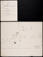
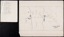
Dundas, Lot 55
Description: This item consists of a fire insurance plan of the community of Dundas and an accompanying typewritten text document. The map shows the Dundas Road and the buildings in the area. It divides the… more
Province: Prince Edward Island
Type: fire insurance maps
Date Issued (Source): 1888
Georgetown P.E.I.
Description: This is the first of two pages of fire insurance maps of Georgetown. It was created in 1888, revised to 1897, and revised again to 1910. This page concentrates on an area one and a half blocks west… more
Publisher: Chas. E. Goad, Civil Engineer
Province: Prince Edward Island
Type: fire insurance maps
Date Created: 1888-10
Date Modified: 1897-11, 1910-09
Date Issued (Source): 1888
Georgetown P.E.I.: Oct. 1893
Description: This is the second of two (2) pages of fire insurance maps of Georgetown. It was created in 1893 and revised to 1910. The map concentrates on an area one and a half blocks east from West Street,… more
Publisher: Chas. E. Goad, Civil Engineer
Province: Prince Edward Island
Type: fire insurance maps
Date Created: 1893-10
Date Modified: 1910-09
Date Issued (Source): 1888
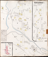
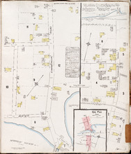
Hunter River P.E.I. Kings Co.: Population 150. No Protection. Oct. 1910.
Description: This is a fire insurance plan of Hunter River. It shows the town in two (2) sections that are intended to be continuous. The sections show the area around the California Road and the Malpeque Raod. A… more
Publisher: Chas. E. Goad, Civil Engineer
Province: Prince Edward Island
Type: fire insurance maps
Date Created: 1910-10
Date Issued (Source): 1888

Kensington P.E.I.: Population 450. 1 Hand Engine, 100' hose. October 1888
Description: This is a fire insurance plan of the village of Kensington. It was created in 1888 and revised to 1910. It focuses on the area of Broadway Street, between Dufferin and Victoria streets, approximately… more
Publisher: Chas. E. Goad, Civil Engineer
Province: Prince Edward Island
Type: fire insurance maps
Date Created: 1888-10
Date Modified: 1910-09
Date Issued (Source): 1888
Miscouche, Lot 17
Description: This item consists of a fire insurance plan of the community of Miscouche and an accompanying handwritten text document. The map of Miscouche focuses on the area of the Fifteen Point Road. It shows… more
Province: Prince Edward Island
Type: fire insurance maps
Date Issued (Source): 1888
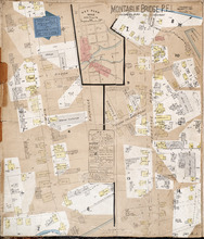
Montague Bridge P.E.I.
Description: This is a fire insurance plan of the village of Montague Bridge consisting of two (2) maps--one for each side of the Montague River. It was created in 1888 and revised to 1910. The map on the left… more
Publisher: Chas. E. Goad, Civil Engineer
Province: Prince Edward Island
Type: fire insurance maps
Date Created: 1888-10
Date Modified: 1910-09
Date Issued (Source): 1888
Mount Stewart Prince Edward Island: Population 400. No Appliances. October 1893.
Description: This is a fire insurance plan of the village of Mount Stewart consisting of two maps--one for each side of the Hillsborough River. It was created in 1893 and revised to 1910. The smaller map, on the… more
Publisher: Chas. E. Goad, Civil Engineer
Province: Prince Edward Island
Type: fire insurance maps
Date Created: 1893-10
Date Modified: 1910-09
Date Issued (Source): 1888
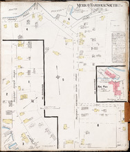
Murray Harbour South P.E.I., Kings Co.: Population 350. No Protection. Octr. 1910
Description: This is a fire insurance plan of the community of Murray Harbour South that consists of two maps--one for each side of the South River. The smaller map, on the left side of the page, shows an area of… more
Publisher: Chas. E. Goad, Civil Engineer
Province: Prince Edward Island
Type: fire insurance maps
Date Created: 1910-10
Date Issued (Source): 1888
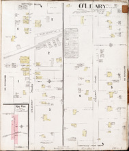
O'Leary P.E.I., Prince Co.: Population 350. No Protection. Oct. 1910
Description: This is a fire insurance plan of O'Leary. It shows the town in two (2) sections that are intended to be continuous. The sections show the area of the O'Leary Road between the Barckley (… more
Publisher: Chas. E. Goad, Civil Engineer
Province: Prince Edward Island
Type: fire insurance maps
Date Created: 1910-10
Date Issued (Source): 1888
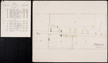
Pownal, Lot 49
Description: This item consists of a fire insurance plan of the community of Pownal and an accompanying typewritten text document. The map shows Pownal divided into numbered sections. It shows buildings and their… more
Province: Prince Edward Island
Type: fire insurance maps
Date Issued (Source): 1888
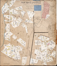
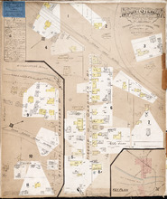
Souris East P.E.I.: Population 3,000. No appliances. Chas E Goad C. E. Montreal. October 1888
Description: This is a fire insurance plan of Souris East showing the the town in two (2) sections that are intended to be continuous. It was created in 1888 and revised to 1910. The map shows the area… more
Publisher: Chas. E. Goad, Civil Engineer
Province: Prince Edward Island
Type: fire insurance maps
Date Created: 1888-10
Date Modified: 1910-09
Date Issued (Source): 1888
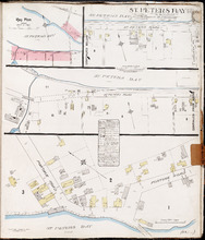
St. Peters Bay P.E.I., Kings Co.: Population 250. No Protection. Octr. 1910
Description: This is a fire insurance plan of the community of St. Peter's Bay that consists of three (3) parts: two maps, one of which is shown in two sections that are meant to be continuous. The largest… more
Publisher: Chas. E. Goad, Civil Engineer
Province: Prince Edward Island
Type: fire insurance maps
Date Created: 1910-10
Date Issued (Source): 1888

Summerside Prince Edward Island: Population: 3,500. July 1903
Description: This item, the first of 11 pages of fire insurance maps of Summerside, serves as the key plan for the other Summerside pages. It was created in 1903, revised to 1910, and then revised again to August… more
Publisher: Chas. E. Goad, Civil Engineer
Province: Prince Edward Island
Type: fire insurance maps
Date Created: 1903-07
Date Modified: 1910-10, 1917-08
Date Issued (Source): 1888

Summerside P.E.I.: Aug. 1917. Reprinted.
Description: This is Page 2 of 11 pages of fire insurance maps of Summerside. It shows the area from Market Street North to the waterfront, between Duke and Central streets. The map shows numbered town blocks and… more
Publisher: Chas. E. Goad, Civil Engineer
Province: Prince Edward Island
Type: fire insurance maps
Date Created: 1917-08
Date Issued (Source): 1888

Summerside, P.E.I.: Oct. 1910. Reprinted
Description: This is the older (1910) version of Page 3 of the Summerside fire insurance maps. The updated map of this town section is shown on Summerside_p3_1917. This map shows the area from Church Street to… more
Publisher: Chas. E. Goad, Civil Engineer
Province: Prince Edward Island
Type: fire insurance maps
Date Created: 1910-10
Date Issued (Source): 1888

Summerside P.E.I.: Aug 1917. Reprinted
Description: This is Page 3 of 11 pages of fire insurance maps of Summerside. This map shows the area from Church Street to the waterfront, between Central and Granville streets. The map shows numbered town… more
Publisher: Chas. E. Goad, Civil Engineer
Province: Prince Edward Island
Type: fire insurance maps
Date Created: 1917-08
Date Issued (Source): 1888

Summerside P.E.I.: July 1903.
Description: This is the older (1903, updated to 1910) version of Page 4 of the Summerside fire insurance maps. A more updated map of this town section is shown on Summerside_p4_1917. This map shows the area from… more
Publisher: Chas. E. Goad, Civil Engineer
Province: Prince Edward Island
Type: fire insurance maps
Date Created: 1903-07
Date Modified: 1910
Date Issued (Source): 1888

Summerside, P.E.I.: Aug. 1917. Reprinted
Description: This is Page 4 of 11 pages of fire insurance maps of Summerside. (An older version of this town section is shown on Summerside_p4_1910.) The map shows the area from Belmont Street to the waterfront,… more
Publisher: Chas. E. Goad, Civil Engineer
Province: Prince Edward Island
Type: fire insurance maps
Date Created: 1917-08
Date Issued (Source): 1888
Summerside, P.E.I.: July 1903
Description: This is Page 5 of 11 pages of fire insurance maps of Summerside. It was created in 1903 and revised to 1910. It shows the area from Myrtle Street to Market Street North, between Duke and Central… more
Publisher: Chas. E. Goad, Civil Engineer
Province: Prince Edward Island
Type: fire insurance maps
Date Created: 1903-07
Date Modified: 1910
Date Issued (Source): 1888
Summerside P.E.I.: July 1903.
Description: This is Page 6 of 11 pages of fire insurance maps of Summerside. It was created in 1903 and revised to 1910. It shows the area from Convent Street to Church Street, between Central and Granville… more
Publisher: Chas. E. Goad, Civil Engineer
Province: Prince Edward Island
Type: fire insurance maps
Date Created: 1903-07
Date Modified: 1910
Date Issued (Source): 1888
Summerside P.E.I.: July 1903.
Description: This is Page 7 of 11 pages of fire insurance maps of Summerside. It was created in 1903 and revised to 1910. It shows the area from Carvell Street to Belmont Street, between Granville and Russell… more
Publisher: Chas. E. Goad, Civil Engineer
Province: Prince Edward Island
Type: fire insurance maps
Date Created: 1903-07
Date Modified: 1910
Date Issued (Source): 1888
Summerside, P.E.I.: July 1903
Description: This is Page 8 of 11 pages of fire insurance maps of Summerside. It was created in 1903 and revised to 1917. It shows an area from the Kirk Street vicinity to the waterfront, east of Russell Street.… more
Publisher: Chas. E. Goad, Civil Engineer
Province: Prince Edward Island
Type: fire insurance maps
Date Created: 1903-07
Date Modified: 1917-08 (year and month uncertain)
Date Issued (Source): 1888
Summerside, P.E.I.: July 1903
Description: This is Page 9 of 11 pages of fire insurance maps of Summerside. It was created in 1903 and revised to either 1910 or 1917. It shows the area from Chestnut Avenue, in the north, to Myrtle and Convent… more
Publisher: Chas. E. Goad, Civil Engineer
Province: Prince Edward Island
Type: fire insurance maps
Date Created: 1903-07
Date Modified: 1910 (year uncertain)
Date Issued (Source): 1888
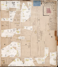
Tignish. P.E.I.: Population 500. No appliances. October 1888
Description: This is an older (1888, revised to 1893) version of a fire insurance plan of the village of Tignish. A more updated plan is shown on the map Tignish_1910. The map shows the area near Chapel Road and… more
Publisher: Chas. E. Goad, Civil Engineer
Province: Prince Edward Island
Type: fire insurance maps
Date Created: 1888-10
Date Modified: 1893-10
Date Issued (Source): 1888
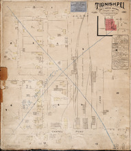
Tignish P.E.I.: Population: 500. Hook & Ladder. Nov 1897.
Description: This is a fire insurance plan of the village of Tignish. It was created in 1897 and revised to 1910. (An older plan is shown on the map Tignish_1893.) The map shows the area near Chapel Road and the… more
Publisher: Chas. E. Goad, Civil Engineer
Province: Prince Edward Island
Type: fire insurance maps
Date Created: 1897-11
Date Modified: 1910-10
Date Issued (Source): 1888
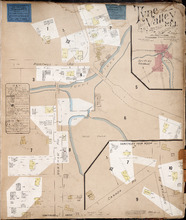
Tyne Valley P.E.I.: Novr. 1897. 1 Mile West of Port Hill Station. Population 300. No Appliances.…
Description: This is a fire insurance plan of Tyne Valley. It was created in 1897, revised to 1903, and then revised again to October, 1910. It shows the town in two (2) sections that are intended to be… more
Publisher: Chas. E. Goad, Civil Engineer
Province: Prince Edward Island
Type: fire insurance maps
Date Created: 1897-11
Date Modified: 1903-07, 1910-10
Date Issued (Source): 1888
Vernon River Bridge, Lot 50
Description: This item consists of a fire insurance plan of the community of Vernon River Bridge and an accompanying handwritten text document. The map of Vernon River shows the community divided into numbered… more
Province: Prince Edward Island
Type: fire insurance maps
Date Issued (Source): 1888
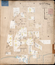
Victoria P.E.I.: Population 300. No appliances. Chas E Goad Civil Engineer Toronto & Montreal.…
Description: This is a fire insurance plan of the village of Victoria. It was created in 1893 and revised to October, 1910. It shows the area from Bardin Street to the waterfront, between Nelson and Russell… more
Publisher: Chas. E. Goad, Civil Engineer
Province: Prince Edward Island
Type: fire insurance maps
Date Created: 1893-10
Date Modified: 1910-10
Date Issued (Source): 1888
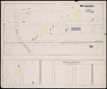
Wellington, Lot 16
Description: This item is a fire insurance plan of the community of Wellington. It shows the village in three (3) sections that are intended to be continuous. The largest map section, across the top of the sheet… more
Province: Prince Edward Island
Type: fire insurance maps
Date Issued (Source): 1888
Murray River South P.E.I., Kings Co.: Population 300. No Protection. Oct 1910
Description: This is a fire insurance plan of the community of Murray River South that consists of two maps--one for each side of the Murray River. The larger map, on the left side of the page, shows an area of… more
Publisher: Chas. E. Goad, Civil Engineer
Province: Prince Edward Island
Type: fire insurance maps
Date Created: 1910-10
Date Issued (Source): 1888

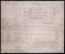
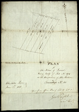
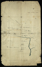
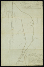
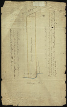
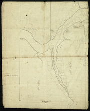
Plan of Lot 23
Description: Plan of Lot 23. Shows names of residents in central portion of Lot, i.e. around Clyde River.
Province: Prince Edward Island
Type: cadastral maps

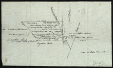
Tracing from Plan of North part of P. E. Island surveyed by Captn. Bayfield
Description: Tracing from plan of North part of Prince Edward Island surveyed by Captain Bayfield. Tracing by H.J. Cundall. Outline of coast, Lots 1-11. (No.94). The map shows bodies of water such as Gulf Shore,… more
Province: Prince Edward Island
Type: cadastral maps

Plan of Building Lots in Common Lots Nos. 28 and 29 (Palmer Estate)
Description: Plan of building lots in Common Lots No.28 and No.29. The Palmer Estate. The map also shows streets such as Euston, Orlebar, lot numbers and acreage.
Province: Prince Edward Island
Type: cadastral maps
Date Created: 1913

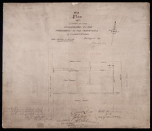
Plan of Right of Way as on the Ground part of Town Lot No. 36 in the 4th Hund. Charlottetown.
Description: Plan of the Right of Way through Town Lot No.36 in the 4th Hundred in Charlottetown. (No.40). The map shows Kent Street and landowners.
Province: Prince Edward Island
Type: cadastral maps
Date Created: 1898-06

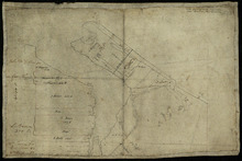
Plan of Lot 61 - Untitled
Description: Plan of Lot 61 (No.163). Sullivan Estate. Shows names of residents, acreage, and some land conveyance references bays and a nautical compass pointing North.
Province: Prince Edward Island
Type: cadastral maps
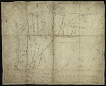
Plan of Township No. 67 Queens County Prince Edward Island: A Copy of a Plan compiled by Geo.…
Description: A copy of a plan of Lot 67 compiled by Geo. Wright, 1858, slightly altered to agree with Meacham's Atlas (No.179). Shows names of residents and acreage, lots, streets and roads, and post offices. more
Province: Prince Edward Island
Type: cadastral maps
Date Created: 1885-07
Plan Shewing the division of Pasture Lots Nos. 61, 62, 70 & 71 in the Royalty of Charlotte Town
Description: Plan showing the division of Pasture or Royalty Lots No.61, No.62, No.70 and No.71 in the Royalty of Charlottetown.
Province: Prince Edward Island
Plan of building lots on the west side of Hillsborough Street, Charlottetown
Description: Plan of building lots on the west side of Hillsborough Street between Grafton and Richmond Streets, Charlottetown. Town Lots No.58, No.59, No.60 and No.95, No.96, No.97 in the 2nd Hund.
Province: Prince Edward Island
Type: cartograms map
Plan of the subdivision of property owned by Mrs. John Longworth in the Commons of Charlottetown:…
Description: Plan of the subdivision of property owned by Mrs. John Longworth in the Commons of Charlottetown, Common Lot No.29. Plan made under the instructions of H.J. Palmer, Trustee for Mrs. John Longworth. (… more
Province: Prince Edward Island
Type: cadastral maps
Date Created: 1923-07-19
Part of Common Lot No. 22.
Description: Plan of part of Common Lot No.22, Charlottetown.
Province: Prince Edward Island
Type: cadastral maps
Date Created: 1886
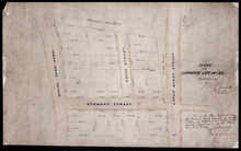
No. 3 Plan of a Tract of Land Appropriated by the Commissioners of the Water-works of Charlottetown
Description: Plan of a tract of land in Charlottetown Royalty appropriated by the Commissioners of the Water-works of Charlottetown. (No.3) (Also No.104). Also shown are landowners and acreage.
Province: Prince Edward Island
Type: cadastral maps
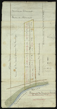
Reserved or Settlement road on Lot 5
Description: Plan of part of Lot 5. The farms on the north side of the Reserved or Settlement Road. The map shows 20 parcels of land on the north side of the Reserve or Settlement Road in the western portion of… more
Province: Prince Edward Island
Type: cadastral maps
Plan Shewing the Situation of Plot No. 94 on Lot or Township No. 15
Description: Plan of part of Lot 15 (No.74). Shows the situation of Plot No.94, the property of John MacInally. 77 acres. MacInally's plot is shaded green. Map also shows Joseph Gallant's Plot No. 93 to… more
Province: Prince Edward Island
Type: cadastral maps
Plan of 50 Acres of Land being half of Lot No. 171 in the Occupation of John Rechore in Township No…
Description: Plan of part of Lot 15. 50 acres of land, part of 171 in the occupation of John Rechore. Also shows (sub) lots 170, 172, 173 and 174. Copied from office plan of Lot 15. (No.3)
Province: Prince Edward Island
Type: cadastral maps
Date Created: 1851-06-03
Plan of 500 Acres Land in Egmont Bay 7th February 1814
Description: The map shows 500 acres of land around the mouth of the Haldimand River in Egmont Bay, northeast of Cape Egmont. Plan of part of Lot 15 (No.4).
Province: Prince Edward Island
Date Created: 1814-02-07
Half Lot No. 18
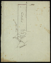
Description: Plan of the eastern half of Lot 18 (No.3). Mainly outline.
Province: Prince Edward Island
Plan Shewing the position of Common Lot No. 18: from actual survey by Joseph Ball
Description: Plan of the part of Charlottetown showing the position of Common Lot No. 18 on the west side of West Street. Gives names of residents on that side of the street. Shows numbered common lots in the… more
Province: Prince Edward Island
Type: cadastral maps
Part of Lot 18
Description: Plan of part of Lot 18 (No.6). Two Ramsay properties, each 100 acres in size, along Oyster Cove in Lot 18. Sandy and/or marshy areas shown with stippling/shading. North arrow.
Province: Prince Edward Island
Type: cadastral maps
Plan Shewing the Alteration of the West Settlement Road "as colored" together with the…
Description: Plan showing the alteration of the West Settlement Road together with the actual settlers on the same. Lot 22. The maps shows an alteration to a portion of the West Settlement Road in Lot 22. The… more
Province: Prince Edward Island
Type: cadastral maps
Date Created: 1870-03-01
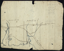
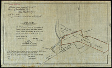
Plan of Proposed Road on A. Dickerson's Farm Township No. 23: Surveyed by John P. Nicholson P…
Description: Plan of proposed road on A. Dickerson's Farm on Lot 23. (No.53). The plan shows a proposed new road, coloured orange, through Arthur Dickerson's farm between Rennie Road and St. Mary's… more
Province: Prince Edward Island
Type: engineering maps

Part of Lot 25
Description: Plan of part of Lot 25 (No.4). Thompson-Taylor land. This item consists of 2 maps——on separate pieces of paper——of the parcels of land belonging to John Thompson (200 acres) and William Taylor (320… more
Province: Prince Edward Island
Type: cadastral maps
Date Created: 1809-11-20
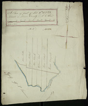
Plan of 75 Acres of land leased to John Clay, showing the different divisions in which it was…
Description: Plan of part of Lot 26. The plan shows 75 acres of land in the western part of Lot 26 leased to John Clay and then later divided and conveyed to other individuals. The plan shows names of residents… more
Province: Prince Edward Island
Type: cadastral maps
Date Created: 1878-08-05
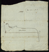
Lot 28 -- No. 2
Description: Plan of part of Lot 28 (No.2). The map shows 200 acres of land along the Northumberland Strait between Crapuad Creek and the Tryon River in Lot 28. Areas that appear to be marshes are indicated with… more
Province: Prince Edward Island
A Plan of part of Lot No. XXVIII. Situate in Prince County P. E. Island
Description: Plan of part of Lot 28 (No.3). The map shows 6 parcels of land with residents' names at Cape Traverse in Lot 28. The Northumberland Strait (which is labelled as the Gulf of St. Lawrence) is… more
Province: Prince Edward Island
Type: cadastral maps
Part of Lots 28 and 29
Description: Plan of part of Lots 28 and 29 (No.9). The maps shows the area around the Tryon and Westmoreland (or Crapaud) rivers in Lots 28 and 29. It gives the names of a few residents and shows several roads,… more
Province: Prince Edward Island
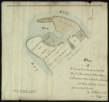
Entrance to the Croppo River
Description: Plan of part of Lot 29 (No.4). Entrance to Croppo River. Shows soundings at Crapaud Harbour. The map shows the harbour and entrance to the Crapaud (or Westmoreland) River. Soundings appear to be… more
Province: Prince Edward Island
Plan of 117 ½ Acres of Land in the possession of James C. Wright together with several adjoining…
Description: Plan of part of Lot 29. 117½ acres of land in the possession of James C. Wright together with several adjoining tracts. Traced from original unsigned plan of Mr Clay by Thos. MacKinlay, June 17, 1882… more
Province: Prince Edward Island
Type: cadastral maps
Date Created: 1879-11-28
Plan of 100 Acres of Land Part of Lot or Township No. 32.: Situate in Queens County In the Island…
Description: Plan of part of Lot 32 (No.5). 100 acres of land, the property of Alexr. McKenzie. The plan shows 100 acres of land belonging to Alexander McKenzie, outlined in yellow, on the west side of the York (… more
Province: Prince Edward Island
Type: cadastral maps
Part of Lot 32: The property of Robert Hodgson
Description: Plan of part of Lot 32 (No.6). The map shows 200 acres of land, outlined in yellow, belonging to Robert Hodgson on the west side of the Prince Town Road in Lot 32. It shows some neighbouring parcels… more
Province: Prince Edward Island
Type: cadastral maps
Date Created: 1810
Refugee Lots on Lot 32 Prince Edward Island: Copied from the Original Plan
Description: Plan of Refugee Lots on Lot 32. Copied from the original. The map shows a northern portion of Lot 32 divided into numbered refugee lots, each 100 acres in size. It gives the names of some residents,… more
Province: Prince Edward Island
Type: cadastral maps
Date Created: 1809
Part of Lot 32: Refugee Lots
Description: Plan of part of Lot 32 (No.4). Refugee Lots. The map shows a northern part of Lot 32 that was divided into refugee lots. It gives the names of residents and acreage amounts for some. The map shows a… more
Province: Prince Edward Island
Type: cadastral maps
Part of Lot 32
Description: Plan of part of Lot 32. North Milton area. The map shows the area around the intersection of the New Glasgow and Rustico roads in the northern part of Lot 32. The land is divided into parcels with… more
Province: Prince Edward Island
Type: cadastral maps
Part of Lot 33: Area around Rustico Bay
Description: Plan of part of Lot 33. Area around Rustico Bay. The map shows the area around Rustico Bay in the northwest part of Lot 33. It shows the land divided into parcels with names of some residents and… more
Province: Prince Edward Island
Type: cadastral maps
Parts of Lot 33: Two maps showing the northern extremities of the east and west boundaries of Lot 33
Description: Plans of two parts of Lot 33 (No.4): McMillan's Point; Grand Pere Point. This item consists of 2 maps on one sheet--one each on the front and back. Side One shows McMillan Point on Covehead Bay… more
Province: Prince Edward Island
Type: boundary maps
Part of Lot 34
Description: Plan of part of Lot 34 (No.5). Shows properties of John Millar, L. Brown, Neil Shaw, Murdock McCloud, and John Crabtree. The map shows the northwestern portion of Lot 34 divided into parcels of land… more
Province: Prince Edward Island
Type: cadastral maps
Part of Lot 34
Description: Plan of part of Lot 34 (No.3). Area around Covehead Bay. The map shows the northwestern portion of Lot 34, divided into parcels of land with the names of residents and/or proprietors and their… more
Province: Prince Edward Island
Type: cadastral maps
Part of Lot 34
Description: Plan of part of Lot 34 (No.6). Area around Covehead Bay. The map shows the northwestern portion of Lot 34 divided into parcels of land with the names of residents and/or proprietors and their acreage… more
Province: Prince Edward Island
Type: cadastral maps
A Draugth of the new road opened by order of his Excellency Governor Smith, for the west settlement…
Description: Plan of part of Lot 34 (No.41). This plan shows a new road in the Covehead area in the northwest corner of Lot 34. It describes the land surrounding the road with labels noting swamp or hardwood… more
Province: Prince Edward Island
Type: engineering maps
Date Created: 1824
Plan of Mrs. Vickersons Land
Description: Plan of part of Lot 34 (No. 4). 74 acres of land. The map shows Barbarey Vickerson's 74-acre parcel of land on the north side of the Hillsborough River in Lot 34. The plan shows roads, including… more
Province: Prince Edward Island
Type: cadastral maps
Date Created: 1809-10-12
Plan of A tract of Land the property the Messrs. Macmillans & Peter Higgins on Township No. 34…
Description: Plan of part of Lot 34 (No. 182). The map shows a parcel of land 111 acres in size belonging to Angus MacMillan, Peter Higgins and Alexander MacMillan near the entrance to Covehead Harbour and what… more
Province: Prince Edward Island
Type: cadastral maps
Date Created: 1854
Plan of the Indian Reserve on Township No. 36
Description: Plan of part of Lot 36. The map shows a parcel of land, approximately 150 acres in size, identified as an Indian Reserve on the north side of the Hillsborough in Lot 36. The parcel is outlined in… more
Province: Prince Edward Island
Type: cadastral maps
Plan Shewing the front of Lots No.s 36 & 37
Description: Office copy from the original survey of Prince Edward Island showing the front of Lots 36 and 37. (No.3) The map shows the northern-most portions of Lots 36 and 37 on the north shore, east of… more
Province: Prince Edward Island
Type: boundary maps
Date Created: 1840-09-11
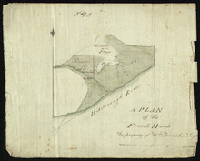
A Plan of the French Marsh: the property of Wm. Townshend. Esqr.
Description: Plan of part of Lot 37 (No.9). The French Marsh. The map shows a marsh area belonging to William Townshend on the north side of the Hillsborough River in Lot 37. Marsh area is shaded and coloured… more
Province: Prince Edward Island
Type: cadastral maps, topographic maps
Lot 37 - No. 7
Description: Plan of part of Lot 37 (No. 7). Area south of the Hillsborough River. The maps shows a small area on the south side of the Hillsborough River in Lot 37 adjacent to the boundary with Lot 38. It shows… more
Province: Prince Edward Island
Type: cadastral maps
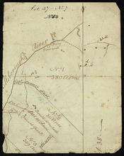
Plan of 150 Acres of Land Part of Lot No. 37.
Description: Plan of part of Lot 37 (No. 8). 150 acres of land, the property of John Stowe. The map shows a parcel of land, approximately 150 acres in size, outlined in yellow, on the north side of the… more
Province: Prince Edward Island
Type: cadastral maps
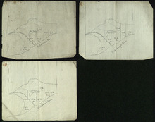
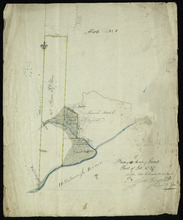
Plan of the French Marsh: Lot 37 - No. 10
Description: Plan of part of Lot 37 (Nos. 10 and 58). This item consists of three maps on three separate sheets, all showing the same area. The maps show the French Marsh on the north side of the Hillsborough… more
Province: Prince Edward Island
Type: cadastral maps, topographic maps
Lot 37 - No. 12
Description: Plan of part of Lot 37 (No. 12). The Pisquid or Hill River area. Outline. The map shows the area where the Pisquid (or Hill) River joins the Hillsborough River in Lot 37. It gives the names of some… more
Province: Prince Edward Island
Type: cadastral maps, topographic maps
Part of Lot 37
Description: Plan of part of Lot 37 (No. 13). Property of Mr. Leech.[?] The map shows a parcel of land on the north side of the Hillsborough River in Lot 37. It gives the names of two residents. The map shows the… more
Province: Prince Edward Island
Type: cadastral maps
Part of Lot 38
Description: Plan of part of Lot 38 (No. 8). Coffin property. 220 acres of land bordering on Savage Harbour. The map shows the northwestern-most part of Lot 38 that is separated from the rest of the lot by Savage… more
Province: Prince Edward Island
Type: cadastral maps
Part of Lot No. 38
Description: Plan of part of Lot 38 (No. 8), Coffin property. 220 acres of land bordering on Savage Harbour. The map shows the northwestern-most part of Lot 38 that is separated from the rest of the lot by Savage… more
Province: Prince Edward Island
Type: cadastral maps

Part of Lot 38
Description: Plan of part of Lot 38 (No. 9). 1100 acres, the property of Alex Watts. The map shows part of Lot 38, including a parcel of land belonging to Alexander Watts. It gives the names of several other… more
Province: Prince Edward Island
Type: cadastral maps
Part of Lot 38: No. 13
Description: Plan of part of Lot 38 (No.13). 900 acres, the property of Alex Watts. Part of plan is missing. The map shows a 900-acre parcel of land belonging to Alexander Watts Esqr. in the northwestern corner… more
Province: Prince Edward Island
Type: cadastral maps
Part of Lot 38: No. 14
Description: Plan of part of Lot 38 (No. 14). Capt. Bentinck's land. The map shows a parcel of land belonging to Captain Bentinck, north of the Hillsborough River in Lot 38. It gives names of residents and… more
Province: Prince Edward Island
Type: cadastral maps
The Original Plan of Charlottetown Lots, No.1.
Description: Early plan of Charlottetown entitled "The Original Plan of Charlottetown Lots, No.1." Shows town lots, houses, windmill, battery, gallows, and the names of residents. Also includes code… more
Province: Prince Edward Island
Type: cadastral maps
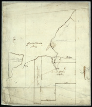
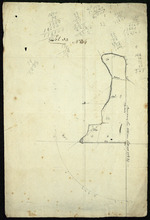
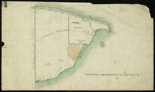
Plan of Part of Lot No. 23
Description: Plan of the northern part of Lot 23 (No.62). Hodgson Estate. Shows names of residents and acreage, Gulf of St. Lawrnce, creeks, rivers, and roads. Color code indicates free and leased land.
Province: Prince Edward Island
Type: cadastral maps

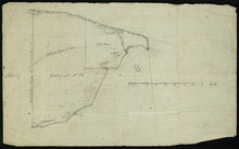
Plan of the Estate of D.S. Rennie Esqr. on Lot No. 23 in Queens County Prince Edward Island: As…
Description: The map shows a southern portion of Lot 23 divided into numbered parcels of land with the names of residents and their acreage amounts. Some parcels are coloured green. The map also shows the land… more
Province: Prince Edward Island
Type: cadastral maps
Date Created: 1863
Plan of Township No. 23
Description: Plan of Lot 23. Shows the estates of Susan Rennie, David S. Rennie and Daniel Hodgson. Gives names of residents, acreage, and a few land conveyance references, rivers, gulfs, roads, towns, and a… more
Province: Prince Edward Island
Type: cadastral maps

Plan of Part of Lot or Township No.23 in grenville Parish in Queens County, Prince Edward Island
Description: Plan of part of Lot 23 (No.61). The estate of David Rennie. Shows names of residents, acreage, and some land conveyance references, rivers, and roads.
Province: Prince Edward Island
Type: cadastral maps
Date Created: 1864-05
Plan Shewing the situation of the respective Fishing Establishments, Fronting Harris or Rustico Bay…
Description: Plan of part of Lot 24. Shows situation of the fishing establishments fronting Harris or Rustico Bay. From actual survey. The map shows the Harbours Mouth and Robinsons Island.
Province: Prince Edward Island
Type: cadastral maps
Date Created: 1869-09-02