Displaying 1 - 108 of 220

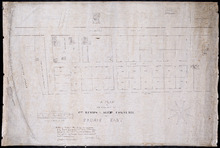
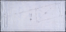
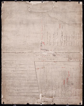
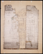
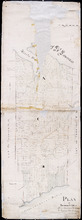
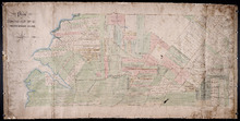
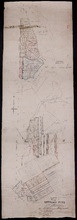
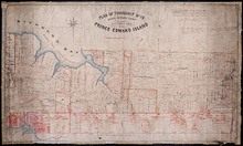
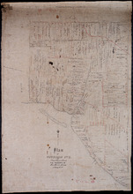
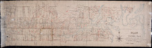
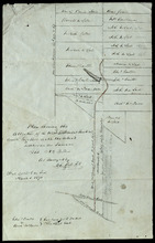
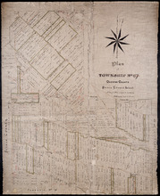
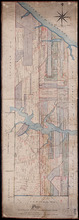
Plan of that portion of the town of Summerside laid off on the front of the farm by Mr. Jesse Green.
Description: Plan of that portion of the town of Summerside laid off on the front of the farm by Mr. Jesse Green. The map shows lots, residents, towns, cities, roads, and bodies of water.
Province: Prince Edward Island
Type: cadastral maps
Date Created: 1868-11-25
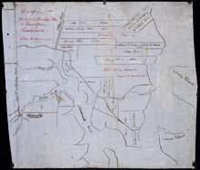
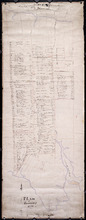
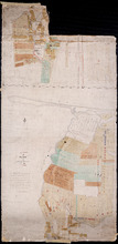
A Plan of the Property of Capt. Simon and Alexander Cheverie: in Souris East
Description: A plan of the property of Capt. Simon and Alexander Cheverie in Souris East. The map shows lots, acreage, roads/streets, and buildings.
Province: Prince Edward Island
Type: cadastral maps
Date Created: 1879-06-18

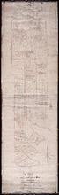
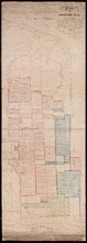
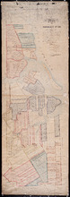
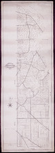
Common Lot No 21 as divided into Building Lots
Description: Plan of Common Lot No.21. Charlottetown as divided into building lots. (No.380) The map shows lots, acreage and roads/streets.
Province: Prince Edward Island
Type: cadastral maps
Date Created: 1872-08

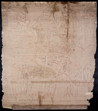
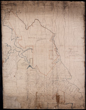
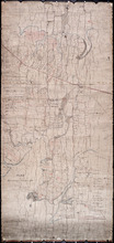
Plan of Lot 5
Description: Plan of Lot 5. Shows names of residents and acreage, rivers, creeks, roads, bays and Islands.
Province: Prince Edward Island
Type: cadastral maps

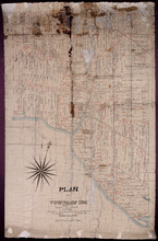
Plan of George Town: The Town Lots are 84 by 120 Feet. The North and South Streets are 100 Feet.…
Description: Plan of Georgetown showing lots and streets, bays, ranges, squares, and a school house. Also shows location of school house. Copy from the Office Plan No.6.
Province: Prince Edward Island
Date Created: 1853-06-07

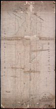
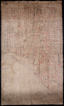
A Plan of Township No 4 Part of the Cunard Estate Prince County P.E.Island
Description: A plan of Lot 4, part of the Cunard Estate. Copied from plans in the Public Lands Department. The map shows lots, residents, bodies of water such as rivers, railways, and roads.
Province: Prince Edward Island
Type: cadastral maps
Date Created: 1885-06
Part of Lot 12 : copied from Township Plan in Land Office Charlottetown
Description: Plan of part of Lot 12 - North Shore. Shows names of some residents, acreage, roads, creeks, Islands, towns and cities. Copied from Township Plan in the Land Office at Charlottetown.
Province: Prince Edward Island
Type: cadastral maps

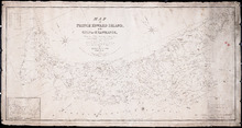
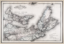
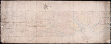
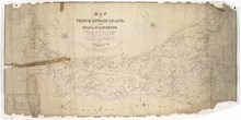
Map of Prince Edward Island
Description: Map of Prince Edward Island. Shows roads, ponds, rivers, towns, cities, grist mills, saw mills, and churches.
Province: Prince Edward Island
Type: cadastral maps

Plan Shewing lands in Charlottetown Appropriated fro Railway purposes : The Figures 67 &c.…
Description: Plan showing lands in Charlottetown appropriated for Railway purposes. The map shows lots, residents, streets, and wharfs.
Province: Prince Edward Island
Type: cadastral maps
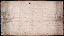
Map of Prince Edward Island, in the Gulf of St. Lawrence: Comprising the latest Topographical…
Description: Map of Prince Edward Island by George Wright, Surveyor General, 1852. Shows mail routes, roads, churches, water mills, population, boundaries, and post offices.
Province: Prince Edward Island
Type: cadastral maps
Date Created: 1852

Plan of North River from Victoria Park to North River Bridge: Showing Subdivisions to be leased for…
Description: Plan of North River from Victoria Park to North River Bridge showing subdivisions to be leased for Oyster Culture. (No.5) The map shows residents, lots, measurements, and roads.
Province: Prince Edward Island
Type: cadastral maps
Date Created: 1913-02-15
Plan showing 0.604 acres of land acquired from Leo Praught, Lot 50, for the Provincial Highway
Description: Plan showing 0.604 acres of land acquired from Leo Praught, Lot 50, for the Provincial Highway. The map shows measurements, acres, some residents and roads and where those roads lead too.
Province: Prince Edward Island
Type: cadastral maps
Date Created: 1939-05
Plan of part of Lot 49: Tea Hill, Charlottetown Exchange.
Description: Plan of part of Lot 49. Tea Hill. Charlottetown Exchange. Shows property owned by the Island Telephone Co. Ltd. (Grid co-ordinates)
Province: Prince Edward Island
Type: cadastral maps

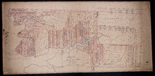
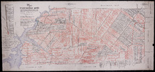
Plan of Charlotte Town Shewing the true position of the Streets and the encroachments thereon.…
Description: The map shows the street grid, numbered town lots and public squares of Charlottetown. It shows some buildings and some of the roads leading to/from the town.
Province: Prince Edward Island
Type: plans
Date Created: 1833
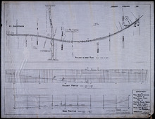
Plan of Proposed Railway Crossing North River to Mount Edward Roads
Description: Plan of proposed Railway crossing North River to Mount Edward Road. Department of Public Works and Highways, Province of Prince Edward Island. Plan shows 3 drawings consisting of the Railway &… more
Province: Prince Edward Island
Type: cadastral maps, transportation maps
Date Created: 1949

Plan of that part of Lot or Township No. 55, lying North: lying North of Boughton River shewing the…
Description: Plan of that part of Lot or Township 55 lying north of Boughton River showing the situation of the respective plots as coloured green which are still in the Crown. The map shows bodies of water such… more
Province: Prince Edward Island
Type: cadastral maps
Date Created: 1845

Lot 6: No. 19
Description: Plan of Lot 6 (No. 19). Cunard Estate. Shows names of residents, acreage, and some land conveyance references, bodies of water such as rivers, and roads.
Province: Prince Edward Island
Type: cadastral maps
Plan of part of The Western Road.: W. Curtis
Description: (No. 46). The map shows a plan of the Western Road from St. Eleanor's to Lot 10. The road passes through Lots 10, 11, 12, 13, 14, 16 and 17. The map shows part of the Ellis River and other… more
Province: Prince Edward Island
Type: plans

Plan of Township No. 4: Compiled from the plans, leases, deeds, and other documents on file in the…
Description: The map shows Lot 4 divided into parcels of land with the names of residents, their acreage amounts and land conveyance references. The map shows roads in a light brown colour. It shows the P.E.I.… more
Province: Prince Edward Island
Type: cadastral maps
Date Created: 1911-06
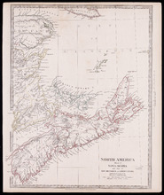
North America Sheet 1 : Nova Scotia with part of New Brunswick and Lower Canada
Description: North America, sheet 1, Nova Scotia with part of New Brunswick and Lower Canada. Published by Society for the Diffusion of Useful Knowledge. The map shows provinces, bodies of water, cities and towns… more
Province: Prince Edward Island, New Brunswick, Nova Scotia
Type: cadastral maps
Date Created: 1832-12-15

Prince Edward Island Nova Scotia and New Brunswick: Prince, Queens and Kings Counties, P.E.I.…
Description: Prince, Queens and Kings Counties, Prince Edward Island, portions of New Brunswick, Nova Scotia, and Magdalen Islands. It marks counties, parishes, cities, towns, and villages, beaches, marshes, Lots… more
Publisher: Hydrographic and Map Service, Labelle Building
Province: Prince Edward Island, Nova Scotia, New Brunswick, Quebec
Type: cadastral maps
Date Created: 1940

Plan of Lot or Township No 4, in P.E. Island: The shores and the division Lines coloured according…
Description: Plan of Lot 4. The shores and the division lines colored to yellow are according to actual survey. Shows names of some residents, acreage, roads, and bodies of water such as rivers.
Province: Prince Edward Island
Type: cadastral maps

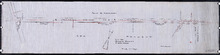
Plan of a Line of Road from Montague River Bridge to Wood Islands: Run in November 1833
Description: Plan of a line of road from Montague River Bridge to Wood Islands. Passes through Lots 59, 60, 61, and 62. (No.59). Shown are residents, lots, and rivers.
Province: Prince Edward Island
Type: cadastral maps
Date Created: 1833-11

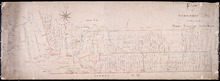
Plan of Lot No 1 Shewing the Extent of the Fishery Reserve to the Crown and situation of settlers…
Description: Plan of Lot 1 (No.6) showing the extent of the Fishery Reserve to the Crown and situation of settlers thereon. Also the site of the respective fishery establishments of the same, as delineated from… more
Province: Prince Edward Island
Type: cadastral maps
Date Created: 1853-10
P.E.I. Railway Murray Harbour Branch : Plan Branch Line From Village Green to Vernon River Bridge
Description: Prince Edward Island Railway. Murray Harbour Branch. Plan of the branch line from Village Green to Vernon River Bridge (No.588). Plan produced by Wm. B. MacKenzie, Chief Engineer. The map shows lots… more
Province: Prince Edward Island
Type: cadastral maps
Date Created: 1906-05-28
Plan No 1 Office of the Registar of Deeds: Charlottetown P.E.Island
Description: Plan of land appropriated for the construction of the Murray Harbour Branch Railway through Queen's County (No.1). Plan produced by Wm. B. MacKenzie, Chief Engineer. The map shows residents,… more
Province: Prince Edward Island
Type: cadastral maps
Date Created: 1900-06-07
Plan of Cape Traverse Branch: Prince Edward Island Railway
Description: Canadian Government Railways, Prince Edward Island. Cape Traverse subdivision. Plans of the Railway right of way from Emerald Junction to Port Borden. Copied from the plans in the Engineer's… more
Province: Prince Edward Island
Type: cadastral maps
Plan of Railway appropriations in Lots 26, 27 and 28
Description: Plan of Railway appropriations in Lots 26, 27 and 28. The map shows lots, roads, residents, and acreage.
Province: Prince Edward Island
Type: cadastral maps, transportation maps
P.E.I. Railway: Elmira Branch Plan of Right-of-Way
Description: Prince Edward Island Railway. Elmira Branch. Plan of Right-of-Way (No.429, Kings Co.). Plan created by Wm. B. MacKenzie, Chief Engineer. The map shows lots, roads, residents, and acreage.
Province: Prince Edward Island
Type: cadastral maps
Date Created: 1909-06-02

Plan of Part of the Railway Line on Lots No 17.
Description: Plan of part of the Railway Line on Lot 17. Appropriations from the French Purchase to the Linkletter Road. The map shows roads, residents and acreage.
Province: Prince Edward Island
Type: cadastral maps, transportation maps
Date Created: 1872-04-29
Railway appropriations from Hunter River to Clyde Station: Lots 22 and 23
Description: Railway appropriations from Hunter River to Clyde Station. Lots 22 and 23. The map shows residents and acreage, roads, stations, ponds, and foliage.
Province: Prince Edward Island
Type: cadastral maps
Date Created: 1872
Plan-showing the Right of Way : Cape Traverse Branch P.E.I
Description: Plan showing the right of way of the Cape Traverse Branch of the Prince Edward Island Railway. The map shows roads, residents and acreage.
Province: Prince Edward Island
Type: cadastral maps

Plan Alterations of Railway on Lot 17 and Station Grounds at Summerside.
Description: Plan of Alterations of the Railway on Lot 17 and the Station Grounds at Summerside. The map shows lots, residents, streets, wharfs, and buildings.
Province: Prince Edward Island
Type: cadastral maps
Date Created: 1872-10-10

Topographical map of Prince Edward Island
Description: Topographical map of Prince Edward Island. Map has been cut into sections and pieced together. Therefore scale, date, etc. is missing. The maps shows mulitple bodies of water, counties, roads, towns… more
Province: Prince Edward Island
Type: cadastral maps

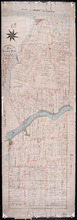
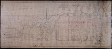
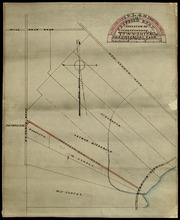
Plan of Township No. 67, and its environs.: Compiled from Surveys by Geo. Wright; H.J. Cundall;…
Description: Plan of Lot 67 and its environs. Compiled from surveys by Geo. Wright, H.J. Cundall, Joseph Ball, and Owen Curtis. Drawn by Thomas MacKinlay. Shows names of some residents, roads, railroads, bodies… more
Province: Prince Edward Island
Type: cadastral maps
Date Created: 1877-08-01
Stanhope Shore Rd.
Description: The map shows the Stanhope Shore Road with the names of residents, their road frontage measurements and dollar amounts for each.
Province: Prince Edward Island
Type: cadastral maps
Date Created: 1954
Plan of the Cunard and Palmer Estates in Lot or Township No.1.
Description: Plan of Lot 1 (No.1). Cunard and Palmer Estates. Drawn by Owen Curtis. Shows names of residents, acreage, and a few land conveyance references, and roads.
Province: Prince Edward Island
Type: cadastral maps

Plan of Township No. 63: compiled from the proprietors' plans, descriptions in leases and…
Description: Plan of Lot 63 compiled from the proprietors' plans, descriptions in leases and registered deeds, and from Meacham's Atlas, with additions and corrections from surveys made at various times… more
Province: Prince Edward Island
Type: cadastral maps
Date Created: 1921-02

Geological Map of Canada and Newfoundland: Derive from the Results of The Canadian Geological…
Description: Framed map of Canada and Newfoundland. The map is has colours for different land marks, and a table that explains it all. Shown are bodies of water such as rivers, islands, roads, towns, and cities.
Province: Newfoundland, New Brunswick, Prince Edward Island, Nova Scotia, Quebec
Type: geological maps
Date Created: 1866 (year uncertain)
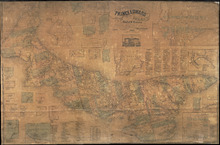
Prince Edward Island: divided into Counties & Parishes, with the Lots, as Granted by Government…
Description: Prince Edward Island divided into Counties and Parishes with the Lots as granted by Government, exhibiting all the New Settlements, Roads, Mills, etc. Published by H. Ashby, King Street, Cheapside,… more
Publisher: Ashby, H.
Province: Prince Edward Island
Type: cadastral maps
Date Created: 1798-03-01

Office copy of that part of the Plan of the new line of Road leading from the Cardigan River to the…
Description: Plan of the new line of road leading from the Cardigan River to the Hillsborough River. Passes through Lots 51, 52, and 38. Plan copied by Geo. Wright, 12 August, 1837. The plan uses a dashed and… more
Province: Prince Edward Island
Type: engineering maps
Date Created: 1833
Plan of land appropriated by the Railway Commissioners in Lots 38 and 51
Description: Prince Edward Island Railway. Plan shows the land appropriated by the Railway Commissioners in Lots 38 and 51. The rail line is drawn in pink. Roads are shown in a lighter colour. Names of residents… more
Province: Prince Edward Island
Type: engineering maps
Plan of Île Saint-Jean: The Island of Saint John
Description: Plan of Ile Saint-Jean / the Island of Saint John. The map shows Prince Edward Island and a portion of the mainland. It identifies settlements, bays, harbours, rivers and islands. Sandy areas are… more
Province: Prince Edward Island
Type: topographic maps
Date Created: 1760
New Railway and Postal Map of the Dominion of Canada, Sheet No. 2
Description: Framed map shows the post offices, money order offices, P.O. saving offices, telegraph sections, ports of entry, railways and the distance between towns over post roads of the time. Prince Edward… more
Province: Prince Edward Island
Type: geological maps
Date Created: 1880

Map of Prince Edward Island in the Gulf of St. Lawrence: for McGregor's British America
Publisher: Ballantyne and Company
Province: Prince Edward Island
Type: cadastral maps, topographic maps
Date Created: 1832
Plan of Lot 50
Description: Plan of Lot 50. Shows names of residents, acreage, and some land conveyance references, roads, and bodies of water such as rivers (Orwell), and bays (Pownal).
Province: Prince Edward Island
Type: cadastral maps

Plan of Township No. 55: Compiled from the plans on file in the Land and Registry Offices, from the…
Description: Plan of Lot 55 compiled from the plans on file in the Land and Registry Offices, from the descriptions in the registered Grants and from Meacham's Atlas. Shows names of residents, acreage, and… more
Province: Prince Edward Island
Type: cadastral maps
Date Created: 1919

Township No. Fiftyfour. St. Georges Parish. Kings County. Prince Edward Island.: Chiefly from…
Description: Plan of Lot 54 (No.145). Shows names of residents, acreage, and some land conveyance references. Copied by H.J. Cundall. Certified plan. The map also shows bodies of water such as rivers (Cardigan),… more
Province: Prince Edward Island
Type: cadastral maps
Plan of the Estate of the Hon. Spencer Cecil Brabazon Ponsonby Fane Situate on Lot or Township No.…
Description: Plan of Lot 53 showing the estate of the Hon. Spencer Cecil Brabazon Ponsonby Fane. Copied by R.T. Weeks. Shows names and acreage of some residents, roads, and rivers such as Morell.
Province: Prince Edward Island
Type: cadastral maps

Plan of Lot or Township No. 51 in Kings County P. E. Island
Description: Plan of Lot 51 (No.139) Colour code shows freehold and unsold portions. Sir Graham Montgomery Estate. Shows names, acreage, and land conveyance references of some residents, and roads.
Province: Prince Edward Island
Type: cadastral maps
Plan of Township No. 50, the Property of Maria Susanna Matilda Fanning
Description: Plan of Lot 50, the property of Maria Susanna Matilda Fanning. Shows names of residents, acreage, and land conveyance references, bodies of water such as rivers (Vernon), bays (Pownal), and roads.… more
Province: Prince Edward Island
Type: cadastral maps

Plan of Part of Township No. 49. Bedford Parish. Queens County. P. E. Island.
Description: Plan of part of Lot 49 (No.135). One of the plans referred to in the deed from Sir Edward, William, and Laura Cunard to the Commissioner of Public Lands, July 13, 1866. The portion of land intended… more
Province: Prince Edward Island
Type: cadastral maps
Date Created: 1850
Plan of part of Lot 50
Description: Plan of part of Lot 50 (No.13). Area east of the Murray Harbour Road, north of the Dundee Road, and south of Georgetown Road. Shows names of residents.
Province: Prince Edward Island
Type: cadastral maps
Plan of Township No. 44.
Description: Plan of Lot 44 (No.120). Cunard Estate. Shows names and acreage of some residents, bodies of water such as rivers and gulfs, roads, and a mills (MacGowans).
Province: Prince Edward Island
Type: cadastral maps
A Plan of Lot or Township No. 43, Comprising the Haviland, Townsend, and Worrell Estates. Compiled…
Description: Plan of Lot 43 (No.116) comprising the Haviland, Townshend, and Worrell Estates. Completed from the surveys of J. Ball and J.C. Underhay by Owen Curtis. Shows names of residents, acreage, and land… more
Province: Prince Edward Island
Type: cadastral maps
Date Created: 1876-08

Plan of Lot 42 (No.112)
Description: Plan of Lot 42 (No.112). Shows names and acreage of some residents, bodies of water, and roads.
Province: Prince Edward Island
Type: cadastral maps
A Map and Survey of Part of Township Number Thirtyfive south side of the Hillsborough river, by…
Description: A map and survey of part of Lot 35, south side of the Hillsborough River. Shows names of residents, acreage, and land conveyance references, bodies of water such as rivers, and raods.
Province: Prince Edward Island
Type: cadastral maps
Date Created: 1887-03

Plan of Lot Thirty Seven: Queens Co., P.E.I.
Description: Map of Lot 37 and part of Lot 38. Map is from Meacham's 1880 PEI Historical Atlas. A few land conveyance references have been added in red ink. The map shows bodies of water such as rivers,… more
Province: Prince Edward Island
Type: cadastral maps
Date Created: 1880
Plan of Fort Augustus and Monaghan Settlement in Township Number 36, in Prince Edward Island, the…
Description: Plan of Fort Augustus and Monaghan Settlement in Lot 36, the property of the Rev. John McDonald. Shows names of residents and acreage, bodies of water such as rivers (Hillsborough), ponds, roads, and… more
Province: Prince Edward Island
Type: cadastral maps
Date Created: 1840
Plan of Township No. 36 Comprising the Estates of Helen Jane MacDonald, Rev. J. A. S. MacDonald and…
Description: Plan of Lot 36 (No.100) comprising the Estates of Helen Jane MacDonald, Rev. J.A.S. MacDonald, and W.C. MacDonald. Shows names of residents, acreage, and land conveyance references, bodies of water… more
Province: Prince Edward Island
Type: cadastral maps
A Plan of part of Township No. 36
Description: A plan of the estate of the late Hon. Donald McDonald comprising part of Lots 35 and 36 divided and apportioned into six shares by Messrs. Aldous, Cundall, and Haythorne under power of an agreement… more
Province: Prince Edward Island
Type: cadastral maps
Date Created: 1865-02-03
A Plan of Township No. 34, The Property of Sir Graham Montgomery & Brothers Situate in Queens…
Description: Plan of Lot 34 (No.89). The property of Sir Graham Montgomery & Brothers. Shows names of residents and acreage, bodies of water such as rivers, and bays, roads, and a nautical compass.
Province: Prince Edward Island
Type: cadastral maps
Date Created: 1850-03-19
Plan of Township No,, 34 in Queens County in P. E. Island. The Property of Messrs,, Montgomeries,…
Description: Plan of Lot 34. Property of Messrs. Montgomery. Shows names of residents and acreage. Plan handed in to Registry Office by Aemeas McDonald. The map also shows bodies of water, bays, rivers, ponds,… more
Province: Prince Edward Island
Type: cadastral maps
Date Created: 1853-08
Plan of Township No. 33. in Prince Edward Island.: referred to in the Deed of Partition [...]
Description: Plan of Lot 33 referred to in the Deed of Partition between Alfred Winsloe, Henry Winsloe, Sydney T. Evans and wife, and Anne Winsloe, March 13, 1863. Shows names of residents and acreage, bodies of… more
Province: Prince Edward Island
Type: cadastral maps
Date Created: 1863-03-13
Plan of Lot 32 (No.86).: Cunard Estate.
Description: Plan of Lot 32 (No.86). Cunard Estate. Shows names of residents, acreage, and some land conveyance references, bodies of water such as creeks and rivers, and roads. Copied by Owen Curtis.
Province: Prince Edward Island
Type: cadastral maps
Date Created: 1876-07
Plan of Township No. 32 situate in the Parish of Charlotte, Queens County, P. E. Island: Scale 20…
Description: Plan of Lot 32 (No.85). One of the plans referred to in the Deed from Sir Edward, William, and Laura Cunard to the Commissioner of Public Lands, July 13, 1866. Shows names of residents, acreage, and… more
Province: Prince Edward Island
Type: cadastral maps
Date Created: 1849
Plan of Township No. 31 in Prince Edward Island
Description: Plan of Lot 31 from H.J. Cundall, one of the Trustees of the Wm. Douse Estate (Death of Wm. Douse in 1864). Shows names of residents, acreages, and some land conveyance references, bodies of water… more
Province: Prince Edward Island
Type: cadastral maps
Plan of Township No. 31: compiled from the proprietors plans and Meacham's Atlas and from the…
Description: Plan of Lot 31 compiled from the Proprietors' plans and Meacham's Atlas and from the descriptions in leases and registered deeds, with additions and corrections from various surveys made… more
Province: Prince Edward Island
Type: cadastral maps
Date Created: 1917-12
Plan of Township No. 26: Embracing the Thomson Holland and Stephens Estates
Description: Plan of Lot 26 embracing the Thomson, Holland, and Stephens Estates. Shows names of residents, acreage, and land conveyance references, bodies of water such as river, cove, and pond, roads, and a… more
Province: Prince Edward Island
Type: cadastral maps
Plan of the North Moriety of a Township No. 26 the Property if the Messrs Thompson of Belfast…
Description: Plan of the North Moiety of Lot 26, the property of the Messrs. Thompson of Belfast Ireland. Shows names of residents, acreage, and a few land conveyance references, bodies of water such as Bedeque… more
Province: Prince Edward Island
Type: cadastral maps
Date Created: 1875-11-05
Plan "A" Part of Township No. 24: as divided amongst the children of the late Alfred…
Description: Plan "A" part of Lot 24 as divided amongst the children of the late Alfred Winsloe (No.64). Shows names of residents and acreage, bodies of water such as rivers, creeks, roads, and a… more
Province: Prince Edward Island
Type: cadastral maps
Date Created: 1872-06-11
This is the Plan of Township No. 24 in Prince Edward Island
Description: Plan of Lot 24 showing the division of the Winsloe Estate. Shows names of residents and acreage, bodies of water such as gulfs, bays, creeks, rivers, sand hills, Rustico or Peter's Island and… more
Province: Prince Edward Island
Type: cadastral maps
Date Created: 1863-03-13
Plan of Township No. 24 in Prince Edward Island
Description: Plan of Lot 24. Smith Estate. Mainly outline but shows a few residents and acreage, bodies of water such as rivers, gulfs, bays and creeks, roads, sand hills, and Rustico or Peter's Island. more
Province: Prince Edward Island
Type: cadastral maps
Plan of the property of Mrs W.L. Smith : Situate on Township No. 24 in Prince Edward Island, Mrs L…
Description: Plan of the property of Mrs W.S. Smith. Situated on Lot 24. The maps shows bodies of water such as rivers and creeks, Rustico Island, roads, and a nautical compass.
Province: Prince Edward Island
Type: cadastral maps
Plan of Township No. 24 Situate in Grenville Parish. Queen's County. P.E.Island.: Complied…
Description: Plan of Lot 21 situate in Grenville Parish (No.54). Compiled from actual surveys. Cunard Estate. Shows names of residents and acreage, bodies of water such as gulfs, rivers, and creeks, roads, and a… more
Province: Prince Edward Island
Type: cadastral maps
Date Created: 1844
Plan of Lot Twenty One : Queens Co P.E.I.
Description: Plan of Lot 21 drawn from old maps, plans, and records. Shows names of residents, acreage, and land conveyance references, bodies of water such as bays, ponds, gulfs, and rivers, roads, and a… more
Province: Prince Edward Island
Type: cadastral maps
Date Created: 1952
Plan of part of Lot 19 (No.48)
Description: Plan of part of Lot 19 (No.48). Hodgson and Yeo Estates. Shows names of some residents, bodies of water such as bays, roads, division lines.
Province: Prince Edward Island
Type: cadastral maps
Plan of Township No. 16 in Prince Edward Island: The Property Of Miss Sullivan
Description: Plan of Lot 16 (No.44). The property of Miss Sullivan. Shows names of residents, bodies of water, roads, and a compass. Color code shows freehold lands purchased from the Proprietor and other… more
Province: Prince Edward Island
Type: cadastral maps
Plan of Township No. 19: Situate in Prince County The Property of A.T.Todd ESQ. Toronto, Prince…
Description: Plan of Lot 19, the property of A.T. Todd, Toronto. Plan referred to in the Indenture dated 11 November, 1871 between A.T. Todd and E.J. Hodgson. Plan also referred to in a conveyance from E.J.… more
Province: Prince Edward Island
Type: cadastral maps
Plan of Lot 14
Description: Plan of Lot 14 (No.40). Cunard Estate. Shows names of some residents, acreage, and a few land conveyance references. The map shows bodies of water such as Ellis (or Grand) River, and Cross River,… more
Province: Prince Edward Island
Type: cadastral maps
Date Created: 1847
Plan of Township No 14: part of the Cunard Estate.
Description: Plan of Lot 14 (No.39). Part of Cunard Estate. Shows names of residents, acreage, and some land conveyance references. The map shows bodies of water, roads, post offices, a railroad station, and a… more
Province: Prince Edward Island
Type: cadastral maps
Plan of Township No. 12
Description: Plan of Lot 12 (No.33). Stewart Estate. Shows names of residents and some acreage and land conveyance references. The map shows bodies of water, roads, a railroad station, and Lennox Island.
Province: Prince Edward Island
Type: cadastral maps
Plan of Part of Lot or Township Number Eleven: by A. Anderson, 1847
Description: Plan of part of Lot 11 (No.31). Stewart Estate. Shows names and acreage of some residents, bodies of water such as rivers, roads, and a compass.
Province: Prince Edward Island
Type: cadastral maps
Date Created: 1847
Plan of Township Number 10. Surveyed by John Ball, L. S.
Description: Plan of Lot 10 (No.28). Stewart Estate. Shows names of residents, acreage, and a few land conveyance references, bodies of water such as rivers, lakes, bays, and creeks, roads, and Bird Island.
Province: Prince Edward Island
Type: cadastral maps
Plan of Township No. 9: Copied from plan furnished by Proprietress with alterations and additions…
Description: Plan of Lot 9 (No.26). Sullivan Estate. Copied from plan furnished by Proprietress with alterations and additions from surveys by Owen Curtis, John Clay &c. Shows names of residents, acreage, and… more
Province: Prince Edward Island
Type: cadastral maps
Date Created: 1883-08-18
Lot 9
Description: Plan of Lot 9 (No.25). Sullivan Estate. Shows names of residents, acreage, and land conveyance references, rivers, roads, and Sandy or Brae Islands.
Province: Prince Edward Island
Type: cadastral maps
Plan of Township No. 9 in Prince Edward Island: The Property of Miss Charlotte Sullivan containing…
Description: Plan of Lot 9 (No.27). The property of Miss Charlotte Sulivan, containing 17300 acres. Shows names of residents and acreage, bodies of water such as rivers, creeks, roads, Sandy or Brae Island, and… more
Province: Prince Edward Island
Type: cadastral maps
Lot 8
Description: Plan of the eastern part of Lot 8 (No.24). Ramsay Estate. Shows names of some residents, acreage, and some land conveyance references, rivers, roads, and sand hills.
Province: Prince Edward Island
Type: cadastral maps
Plan of Township No. 7, Prince County, Prince Edward Island, From Actual Survey by John Clay L. S…
Description: Plan of Lot 7 (No.21). Stewart Estate. Shows names of residents and acreage, bodies of water such as the Gulf of St. Lawrence, ponds, and roads.
Province: Prince Edward Island
Type: cadastral maps
Date Created: 1877-04-09
Plan of Lot or Township No. 5 in Prince Edward Island: The Shore and the Division line, coloured…
Description: Plan of Lot 5. The Shore and the Division line, coloured Yellow are according to actual Survey by A. Anderson. Shows names of residents, acreage, and land conveyance references, bodies of water such… more
Province: Prince Edward Island
Type: cadastral maps
Date Created: 1840
Plan of Township No. 5: Copied from Plans in Land Office, with many addition and corrections from…
Description: Plan of Lot 5 (No.17). Cunard Estate. Copied from plans in Land Office with many additions and corrections from more recent surveys. Also sundry data connecting the lands with their ledger folios,… more
Province: Prince Edward Island
Type: cadastral maps
Date Created: 1886
Plan of building lots on the west side of Hillsborough Street, Charlottetown
Description: Plan of building lots on the west side of Hillsborough Street between Grafton and Richmond Streets, Charlottetown. Town Lots No.58, No.59, No.60 and No.95, No.96, No.97 in the 2nd Hund.
Province: Prince Edward Island
Type: cartograms map
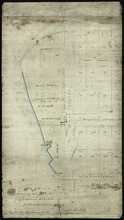
Reserved or Settlement road on Lot 5
Description: Plan of part of Lot 5. The farms on the north side of the Reserved or Settlement Road. The map shows 20 parcels of land on the north side of the Reserve or Settlement Road in the western portion of… more
Province: Prince Edward Island
Type: cadastral maps
Plan Shewing the position of Common Lot No. 18: from actual survey by Joseph Ball
Description: Plan of the part of Charlottetown showing the position of Common Lot No. 18 on the west side of West Street. Gives names of residents on that side of the street. Shows numbered common lots in the… more
Province: Prince Edward Island
Type: cadastral maps
Plan Shewing the Alteration of the West Settlement Road "as colored" together with the…
Description: Plan showing the alteration of the West Settlement Road together with the actual settlers on the same. Lot 22. The maps shows an alteration to a portion of the West Settlement Road in Lot 22. The… more
Province: Prince Edward Island
Type: cadastral maps
Date Created: 1870-03-01
Plan of Proposed Road on A. Dickerson's Farm Township No. 23: Surveyed by John P. Nicholson P…
Description: Plan of proposed road on A. Dickerson's Farm on Lot 23. (No.53). The plan shows a proposed new road, coloured orange, through Arthur Dickerson's farm between Rennie Road and St. Mary's… more
Province: Prince Edward Island
Type: engineering maps
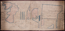
Part of Lots 28 and 29
Description: Plan of part of Lots 28 and 29 (No.9). The maps shows the area around the Tryon and Westmoreland (or Crapaud) rivers in Lots 28 and 29. It gives the names of a few residents and shows several roads,… more
Province: Prince Edward Island
A Draugth of the new road opened by order of his Excellency Governor Smith, for the west settlement…
Description: Plan of part of Lot 34 (No.41). This plan shows a new road in the Covehead area in the northwest corner of Lot 34. It describes the land surrounding the road with labels noting swamp or hardwood… more
Province: Prince Edward Island
Type: engineering maps
Date Created: 1824
Tracing from Plan of North part of P. E. Island surveyed by Captn. Bayfield
Description: Tracing from plan of North part of Prince Edward Island surveyed by Captain Bayfield. Tracing by H.J. Cundall. Outline of coast, Lots 1-11. (No.94). The map shows bodies of water such as Gulf Shore,… more
Province: Prince Edward Island
Type: cadastral maps
Plan of Township No. 67 Queens County Prince Edward Island: A Copy of a Plan compiled by Geo.…
Description: A copy of a plan of Lot 67 compiled by Geo. Wright, 1858, slightly altered to agree with Meacham's Atlas (No.179). Shows names of residents and acreage, lots, streets and roads, and post offices. more
Province: Prince Edward Island
Type: cadastral maps
Date Created: 1885-07
Map of Prince Edward Island, in the Gulf of St. Lawrence,: Compiling the latest Topographical…
Description: Map of Prince Edward Island by George Wright, Surveyor General, 1852. The Sea Coast, Rivers, Vc. being laid down from the Survey recently completed by Captain H. W. Bayfield R.N. The map shows mail… more
Province: Prince Edward Island
Type: cadastral maps
Date Created: 1852
Topographical Map of Prince Edward Island in the Gulf of St. Lawrence
Description: Prince Edward Island divided into Counties and Parishes with the Lots as granted by Government, exhibiting all the New Settlements, Roads, Mills, etc. Published by H. Ashby, King Street, Cheapside,… more
Publisher: W. E. & H. H. Baker
Province: Prince Edward Island
Type: topographic maps, cadastral maps, pictorial maps
Date Created: 1863
Plan Combining both Moieties of Township Number Twenty;: Copied from the Plans handed in by the…
Description: Plan of Lot 20 (No.52). Cunard and Cundall Estates. Copied from the plans handed in by the Proprietors (corrected where necessary by minor surveys, and chainage on leases) by Thos. MacKinlay. Shows… more
Province: Prince Edward Island
Type: cadastral maps
A Plan of Lot No. 61: By John Aldous from survey made in May & June 1842
Description: Plan of Lot 61 (No.162). Sullivan Estate. Landlord's plan. Shows names of residents and acreage. Signed by G.W. DeBlois. The map shows roads, bodies of water such as Sturgeon Bay and River,… more
Province: Prince Edward Island
Type: cadastral maps
Plan of Lot or Township No. 60 Copied from the Survey of Roderick Campbell by Owen Curtis. L. S.…
Description: Plan of Lot 60 (No.161). Copied from the survey of Roderick Campbell by Owen Curtis, 1877. Shows names of residents, acreage, and land conveyance references. The map shows bodies of water such as… more
Province: Prince Edward Island
Type: cadastral maps
Date Created: 1877
Plan of Lot 51 (No.140)
Description: Plan of Lot 51 (No.140). The property of Sir Graham G. Montgomery and others. True copy from a survey made in August, 1838, by George Wright. Copied by Jas. Bevan, 1852. Shows names of residents and… more
Type: cadastral maps
A Plan of the undisposed part of 1/3 of Lot No. 59 Kings County in Prince Edward Island belonging…
Description: A plan of the undisposed part of Lot 59 belonging to the Earl of Selkirk (No.158). Shows names of residents, acreage, and land conveyance references. Surveyed by Rod'k Campbell.The map shows… more
Province: Prince Edward Island
Type: cadastral maps