Displaying 28 - 54 of 171
Plan of the Western Moiety of Township No.20: Grenville Parish, Queens County, P. E. Island
Description: Plan of the Western Moiety of Township No.20, showing residents.
Province: Prince Edward Island
Type: cadastral maps
Date Created: 1850
Plan of Township No. 26: Comprising the Holland, Stephens, and Thomson Estates Copied from the…
Description: Plan of Lot 26 (No.70) comprising the Holland, Stephens, and Thomson Estates copied from the plans in Public Lands Department, corrected by partial surveys and Meacham's Atlas. more
Province: Prince Edward Island
Type: cadastral maps
Date Created: 1885-09

Plan of Township 30
Description: Plan of Lot 30 (No.82). Stewart Estate. Shows names of residents.
Province: Prince Edward Island
Type: cadastral maps
Lot 31: Southern portion
Description: Plan of the southern part of Lot 31, showing residents. In use 1819. From H.J. Cundall.
Province: Prince Edward Island
Type: cadastral maps

Lot 32
Description: Plan of Lot 32 showing some residents.
Province: Prince Edward Island
Type: cadastral maps

Lot 34: Southern portion
Description: Part of Lot 34 (No.7). North side of Hillsborough River.
Province: Prince Edward Island
Type: cadastral maps

Plan of Lot 38
Description: Plan of Lot 38 showing the extent of land in possession of the Government...(?)
Province: Prince Edward Island
Type: cadastral maps

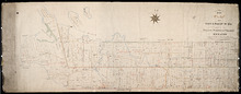
Plan of Lot or Township No. 39: from the lastest Surveys by Joseph Ball, S.G., July 1, 1857
Description: Plan of Lot 39 (No.104). Worrell Estate. Plan copied by Owen Curtis, 1876.
Province: Prince Edward Island
Type: cadastral maps
Date Created: 1857-07-01

Plan of Lot or Township No. 40: From latest Surveys by Joseph Ball and Owen Curtis, Land Surveyors.
Description: Plan of Lot 40 (No.109). Worrell Estate.
Province: Prince Edward Island
Type: cadastral maps

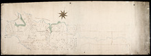
Plan of Lot or Township No. 41: From The Latest Surveys By Joseph Ball S.G., Copied by O. Curtis
Description: Plan of Lot 41 (No.111). Showing residents. Surveyed by Joseph Ball. Plan copied by Owen Curtis.
Province: Prince Edward Island
Type: cadastral maps

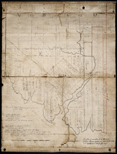
Plan of Township No. 64: St. Andrews Parish, Queens County, P. E. Island
Description: Lot 64 is situated in Kings County, not Queens County as stated in the map title. The map shows Lot 64 divided into parcels of land with names of residents and their acreage amounts. Several parcels… more
Province: Prince Edward Island
Type: cadastral maps
Date Created: 1850

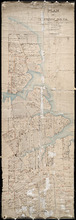
Plan of the Western Portion of Township No. 65: containing 5250 acres and belonging to Mrs. Lydia…
Description: Plan of the western portion of Lot 65 (No.173). Estate of Mrs Lydia Wright. Roads, leased land[?] and freehold land on the Estate of Mrs. Lydia Wright. Tenant names appear on the sub-lots, which are… more
Province: Prince Edward Island
Type: cadastral maps
Date Created: 1841

Plan of Lot or Township No. 34
Description: Plan of Lot 34 (No. 90). Montgomery Estate. Working plan. The map shows Lot 34 divided into parcels of land with the names of residents and their acreage amounts handwritten in black ink. Land… more
Province: Prince Edward Island
Type: cadastral maps

Plan of Township No. 11: compiled from the plans by the late Alexander Anderson L. S on file in the…
Description: The map shows Lot 11 divided into parcels of land with names of residents, their acreage amounts and land conveyance references. Shows the P.E.I. Railway in red, roads in light brown. Bodies of water… more
Province: Prince Edward Island
Type: cadastral maps
Date Created: 1910

Plan of Township No. 56: referred to in the annexed Deed shewing the situation of lands conveyed by…
Description: Plan of Lot 56 showing the situation of 18,028 acres of land conveyed by T. Heath Haviland and G.W. DeBlois to the Commissioner of Public Lands. The map shows Lot 56 divided into parcels of land with… more
Province: Prince Edward Island
Type: cadastral maps


Plan of Township No. 13: From a Survey by Alex Anderson Copied from a Plan made by John Clay…
Description: Plan of Lot 13 - Yeo Estate.
Province: Prince Edward Island
Type: cadastral maps
Date Created: 1878

Plan of Township No. 16 in Prince Edward Island: The Estate of Laurence Sulivan Esq., Dept. Sect.…
Description: Plan of Lot 16, the estate of Lawrence Sullivan, Esq. Copied by Geo. Wright from a plan by James(?).
Province: Prince Edward Island
Type: cadastral maps
Date Created: 1851
Plan of Lot & Township No. 22 in Prince Edward Island: Part of the Estate of the Right…
Description: Plan of Lot 22 (No.59). Sullivan Estate.
Province: Prince Edward Island
Type: cadastral maps

Lot 22
Description: Plan of Lot 22 showing residents.
Province: Prince Edward Island
Type: cadastral maps
Plan of Township No. 24: Copied from plan furnished by Proprietors with numerous corrections from…
Description: Working plan of Lot 24 (No.67). Winsloe Estate. Surveyed by H.J Cundall and others; copied by Thos. MacKinlay.
Province: Prince Edward Island
Type: cadastral maps
Date Created: 1886-02
Lot 26
Description: Plan of Lot 26, partly finished by T. McKinlay. Residents shown for southern part of lot.
Province: Prince Edward Island
Type: cadastral maps

Lot 30: Refugee Share drawn for in Council this 18th day of September 1784, John Spencer
Description: Plan of Lot 30 (No.1) showing Refugee Shares drawn for in Council, 18 September, 1784.
Province: Prince Edward Island
Type: cadastral maps
Date Created: 1784

Plan of Township No. 30 belonging to R. Bruce Stewart, Drawn by Robt. Stewart 1861 from surveys…
Description: The map shows Lot 30 divided into numbered sub-lots. There are nine different series of sub-lot numbers which are colour-coded according to the map legend. The different colours represent Line Road,… more
Province: Prince Edward Island
Type: cadastral maps
Date Created: 1861
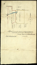
Plan shewing the situation of a Mill-pond Right on Lots 6 and 7, purchased from Samuel Sweet, by…
Description: Plan of part of Lots 6 and 7 showing the situation of a Mill-pond right purchased from Samuel Sweet by Richard Smallman and Chas. Crossman. The mill pond is located in the area where Lots 5, 6 and 7… more
Province: Prince Edward Island
Type: cadastral maps
Part of Lot No. 26
Description: Plan of part of Lot 26 (No.3). Plan traced[?] by J. Plaw from a survey by Mr. Major[?]. The maps shows part of Lot 26 (the Centreville area) divided into parcels of land with the names of residents… more
Province: Prince Edward Island
Type: cadastral maps
Date Created: 1810-05-23