Displaying 217 - 270 of 504
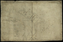
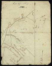
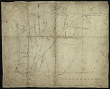
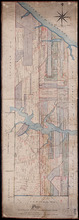
Part of Lot 34
Description: Plan of part of Lot 34 (No.3). Area around Covehead Bay. The map shows the northwestern portion of Lot 34, divided into parcels of land with the names of residents and/or proprietors and their… more
Province: Prince Edward Island
Type: cadastral maps
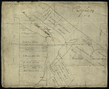
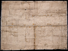
Part of Lot 34
Description: Plan of part of Lot 34 (No.6). Area around Covehead Bay. The map shows the northwestern portion of Lot 34 divided into parcels of land with the names of residents and/or proprietors and their acreage… more
Province: Prince Edward Island
Type: cadastral maps
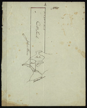
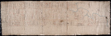
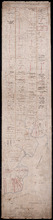
A Draugth of the new road opened by order of his Excellency Governor Smith, for the west settlement…
Description: Plan of part of Lot 34 (No.41). This plan shows a new road in the Covehead area in the northwest corner of Lot 34. It describes the land surrounding the road with labels noting swamp or hardwood… more
Province: Prince Edward Island
Type: engineering maps
Date Created: 1824
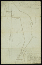
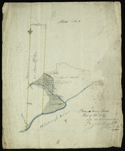
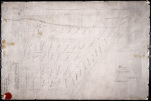
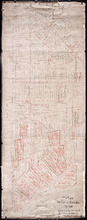
Plan of Mrs. Vickersons Land
Description: Plan of part of Lot 34 (No. 4). 74 acres of land. The map shows Barbarey Vickerson's 74-acre parcel of land on the north side of the Hillsborough River in Lot 34. The plan shows roads, including… more
Province: Prince Edward Island
Type: cadastral maps
Date Created: 1809-10-12
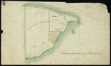
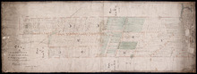
Plan of A tract of Land the property the Messrs. Macmillans & Peter Higgins on Township No. 34…
Description: Plan of part of Lot 34 (No. 182). The map shows a parcel of land 111 acres in size belonging to Angus MacMillan, Peter Higgins and Alexander MacMillan near the entrance to Covehead Harbour and what… more
Province: Prince Edward Island
Type: cadastral maps
Date Created: 1854
Plan of the Indian Reserve on Township No. 36
Description: Plan of part of Lot 36. The map shows a parcel of land, approximately 150 acres in size, identified as an Indian Reserve on the north side of the Hillsborough in Lot 36. The parcel is outlined in… more
Province: Prince Edward Island
Type: cadastral maps
Plan Shewing the front of Lots No.s 36 & 37
Description: Office copy from the original survey of Prince Edward Island showing the front of Lots 36 and 37. (No.3) The map shows the northern-most portions of Lots 36 and 37 on the north shore, east of… more
Province: Prince Edward Island
Type: boundary maps
Date Created: 1840-09-11
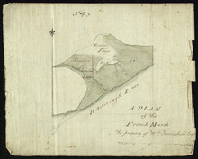
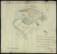
A Plan of the French Marsh: the property of Wm. Townshend. Esqr.
Description: Plan of part of Lot 37 (No.9). The French Marsh. The map shows a marsh area belonging to William Townshend on the north side of the Hillsborough River in Lot 37. Marsh area is shaded and coloured… more
Province: Prince Edward Island
Type: cadastral maps, topographic maps
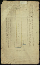
Lot 37 - No. 7
Description: Plan of part of Lot 37 (No. 7). Area south of the Hillsborough River. The maps shows a small area on the south side of the Hillsborough River in Lot 37 adjacent to the boundary with Lot 38. It shows… more
Province: Prince Edward Island
Type: cadastral maps
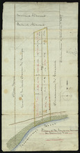
Plan of 150 Acres of Land Part of Lot No. 37.
Description: Plan of part of Lot 37 (No. 8). 150 acres of land, the property of John Stowe. The map shows a parcel of land, approximately 150 acres in size, outlined in yellow, on the north side of the… more
Province: Prince Edward Island
Type: cadastral maps
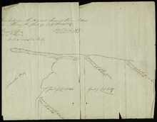
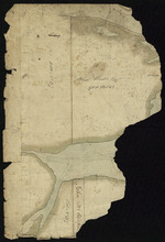
Plan of the French Marsh: Lot 37 - No. 10
Description: Plan of part of Lot 37 (Nos. 10 and 58). This item consists of three maps on three separate sheets, all showing the same area. The maps show the French Marsh on the north side of the Hillsborough… more
Province: Prince Edward Island
Type: cadastral maps, topographic maps
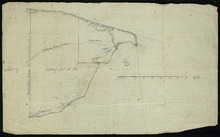
Lot 37 - No. 12
Description: Plan of part of Lot 37 (No. 12). The Pisquid or Hill River area. Outline. The map shows the area where the Pisquid (or Hill) River joins the Hillsborough River in Lot 37. It gives the names of some… more
Province: Prince Edward Island
Type: cadastral maps, topographic maps
Part of Lot 37
Description: Plan of part of Lot 37 (No. 13). Property of Mr. Leech.[?] The map shows a parcel of land on the north side of the Hillsborough River in Lot 37. It gives the names of two residents. The map shows the… more
Province: Prince Edward Island
Type: cadastral maps
Part of Lot 38
Description: Plan of part of Lot 38 (No. 8). Coffin property. 220 acres of land bordering on Savage Harbour. The map shows the northwestern-most part of Lot 38 that is separated from the rest of the lot by Savage… more
Province: Prince Edward Island
Type: cadastral maps
Part of Lot No. 38
Description: Plan of part of Lot 38 (No. 8), Coffin property. 220 acres of land bordering on Savage Harbour. The map shows the northwestern-most part of Lot 38 that is separated from the rest of the lot by Savage… more
Province: Prince Edward Island
Type: cadastral maps

Part of Lot 38
Description: Plan of part of Lot 38 (No. 9). 1100 acres, the property of Alex Watts. The map shows part of Lot 38, including a parcel of land belonging to Alexander Watts. It gives the names of several other… more
Province: Prince Edward Island
Type: cadastral maps
Part of Lot 38: No. 13
Description: Plan of part of Lot 38 (No.13). 900 acres, the property of Alex Watts. Part of plan is missing. The map shows a 900-acre parcel of land belonging to Alexander Watts Esqr. in the northwestern corner… more
Province: Prince Edward Island
Type: cadastral maps
Part of Lot 38: No. 14
Description: Plan of part of Lot 38 (No. 14). Capt. Bentinck's land. The map shows a parcel of land belonging to Captain Bentinck, north of the Hillsborough River in Lot 38. It gives names of residents and… more
Province: Prince Edward Island
Type: cadastral maps
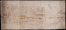
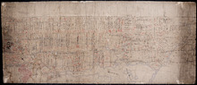
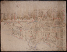
The Original Plan of Charlottetown Lots, No.1.
Description: Early plan of Charlottetown entitled "The Original Plan of Charlottetown Lots, No.1." Shows town lots, houses, windmill, battery, gallows, and the names of residents. Also includes code… more
Province: Prince Edward Island
Type: cadastral maps
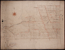
Plan of Lot 23
Description: Plan of Lot 23. Shows names of residents in central portion of Lot, i.e. around Clyde River.
Province: Prince Edward Island
Type: cadastral maps

Plan of Building Lots in Common Lots Nos. 28 and 29 (Palmer Estate)
Description: Plan of building lots in Common Lots No.28 and No.29. The Palmer Estate. The map also shows streets such as Euston, Orlebar, lot numbers and acreage.
Province: Prince Edward Island
Type: cadastral maps
Date Created: 1913

Plan of Right of Way as on the Ground part of Town Lot No. 36 in the 4th Hund. Charlottetown.
Description: Plan of the Right of Way through Town Lot No.36 in the 4th Hundred in Charlottetown. (No.40). The map shows Kent Street and landowners.
Province: Prince Edward Island
Type: cadastral maps
Date Created: 1898-06
Plan of Ardgowan Estate in the Royalty of Charlotte Town
Description: Plan of Ardgowan Estate in the Royalty of Charlottetown as sold by auction, 26th June, 1879. Property of the Hon. J.C. Pope. (No.392). The map shows roads such as St. Peters, Confederation, lots,… more
Type: cadastral maps
Plan of Lot 61 - Untitled
Description: Plan of Lot 61 (No.163). Sullivan Estate. Shows names of residents, acreage, and some land conveyance references bays and a nautical compass pointing North.
Province: Prince Edward Island
Type: cadastral maps
Plan of Township No. 67 Queens County Prince Edward Island: A Copy of a Plan compiled by Geo.…
Description: A copy of a plan of Lot 67 compiled by Geo. Wright, 1858, slightly altered to agree with Meacham's Atlas (No.179). Shows names of residents and acreage, lots, streets and roads, and post offices. more
Province: Prince Edward Island
Type: cadastral maps
Date Created: 1885-07

Plan of Township No. 67 in Prince Edward Island: The Property of Lady Wood
Description: Plan of Lot 67 (No.180). The property of Lady Wood. Shows names of residents, acreage, and some land conveyance references and a compass pointing North.
Province: Prince Edward Island
Type: cadastral maps
Date Created: 1858
Plan of 1390 Acres of Land part of Township No. 65: The Property of the Honble. Samuel Cunard.…
Description: Plan of Lot 65 (No.178). Shows names of residents, acreage, and land conveyance references. Color code indicates freehold land and the estates of the Wrights, Cunard and Cumberland. Shows bodies of… more
Province: Prince Edward Island
Type: cadastral maps
Plan of Part of Township No. 65: The Property of Col. B.H. and Mrs Cumberland
Description: Plan of part of Lot 65 (No.171). The property of Col. B.H. and Mrs Cumberland. Shows names of residents and acreage. Plan copied by R.T. Weeks. The map shows bodies of water such as Elliott River,… more
Province: Prince Edward Island
Type: cadastral maps
Plan of Township 64
Description: Plan of Lot 64 (No.169). Cunard Estate. Shows names of residents, acreage, and land conveyance references. The map shows bodies of water such as Gulf of Saint Lawrence, and Murray River, Murray… more
Province: Prince Edward Island
Type: cadastral maps
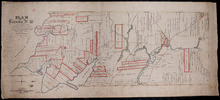
Plan of Lot 63
Description: Plan of Lot 63. Shows names of residents, acreage, and land conveyance references. The map shows bodies of water such as Murray Bay/River, Gulf of St. Lawrence, and Murray Islands.
Province: Prince Edward Island
Type: cadastral maps

A Plan of the undisposed of Parts of Lot No. 62 in Queens County in Prince Edward Island by Rodk.…
Description: A plan of the undisposed part of Lot 62. Selkirk Estate (No.164). Shows names of residents and acreage.
Province: Prince Edward Island
Type: cadastral maps
Date Created: 1860
Plan of Lot 62 (No.165)
Description: Plan of Lot 62 (No.165). Selkirk Estate. Shows names of residents, acreage, and land conveyance references. The map shows a division line, bodies of water, Wood Islands, lots, landowners, acreage,… more
Province: Prince Edward Island
Type: cadastral maps
Plan of Township No. 55: From various Surveys made between the Years 1818 and 1845
Description: The map is a Plan of Township No. 55. The mqp shows bodies of water such as the Cardigan River, and Boughton River, lots, landowers, acreage, and Boughton Island.
Province: Prince Edward Island
Type: cadastral maps
Date Created: 1848-03-21
Plan Combining both Moieties of Township Number Twenty;: Copied from the Plans handed in by the…
Description: Plan of Lot 20 (No.52). Cunard and Cundall Estates. Copied from the plans handed in by the Proprietors (corrected where necessary by minor surveys, and chainage on leases) by Thos. MacKinlay. Shows… more
Province: Prince Edward Island
Type: cadastral maps
A Plan of Lot No. 61: By John Aldous from survey made in May & June 1842
Description: Plan of Lot 61 (No.162). Sullivan Estate. Landlord's plan. Shows names of residents and acreage. Signed by G.W. DeBlois. The map shows roads, bodies of water such as Sturgeon Bay and River,… more
Province: Prince Edward Island
Type: cadastral maps

A Plan of the undisposed of Parts of Lot No. 60 in Queens County in Prince Edward Island by Rodk.…
Description: A plan of the undisposed parts of Lot 60. Code indicates tracts of land sold and tracts of land without lease. Shows names of residents and acreage. Surveyed by Rod'k Campbell. A nautical… more
Province: Prince Edward Island
Type: cadastral maps
Date Created: 1860
Plan of Lot or Township No. 60 Copied from the Survey of Roderick Campbell by Owen Curtis. L. S.…
Description: Plan of Lot 60 (No.161). Copied from the survey of Roderick Campbell by Owen Curtis, 1877. Shows names of residents, acreage, and land conveyance references. The map shows bodies of water such as… more
Province: Prince Edward Island
Type: cadastral maps
Date Created: 1877
Plan of Lot 51 (No.140)
Description: Plan of Lot 51 (No.140). The property of Sir Graham G. Montgomery and others. True copy from a survey made in August, 1838, by George Wright. Copied by Jas. Bevan, 1852. Shows names of residents and… more
Type: cadastral maps
Plan of Lot 59 (No.156)
Description: Plan of Lot 59 (No.156). Montgomery Estate. Shows names, acreage, and land conveyance references for some residents, roads, and a nautical compass.
Province: Prince Edward Island
Type: cadastral maps
A Plan of the undisposed part of 1/3 of Lot No. 59 Kings County in Prince Edward Island belonging…
Description: A plan of the undisposed part of Lot 59 belonging to the Earl of Selkirk (No.158). Shows names of residents, acreage, and land conveyance references. Surveyed by Rod'k Campbell.The map shows… more
Province: Prince Edward Island
Type: cadastral maps
Plan of Township No. 59: Compiled from the proprietors plans, descriptions in leases and registered…
Description: Plan of Lot 59 compiled from the proprietors' plans, descriptions in leases and registered deeds, and from Meacham's Atlas with additions and corrections from surveys made at various times… more
Province: Prince Edward Island
Type: cadastral maps
Date Created: 1922-03
Plan of Township No. 58: Compiled from the proprietors plans and Meacham's Atlas, and from the…
Description: Plan of Lot 58 compiled from the proprietors' plans and Meacham's Atlas and from the descriptions in leases and registered deeds with additions and corrections from various surveys made… more
Province: Prince Edward Island
Type: cadastral maps
Date Created: 1916
Plan of Lot 57
Description: Plan of Lot 57 (No.153). Selkirk Estate. Shows names of residents, acreage, and land conveyance references. A copy from the plan conveying the Estate to the Government and signed by John Aldous. The… more
Type: cadastral maps
Plan of Township No. 56: referred to in the annexed Deed shewing the situation of lands conveyed by…
Description: Plan of Lot 56 showing the situation of 18,028 acres of land conveyed by T. Heath Haviland and G.W. DeBlois to the Commissioner of Public Lands. The map shows Lot 56 divided into parcels of land with… more
Province: Prince Edward Island
Type: cadastral maps
A Plan of Township No. 56 in Kings County P. E. Island, the Property of Hon. T. H. Haviland of…
Description: Plan of Lot 56 (No.149). Property of Hon. T.H. Haviland of Charlottetown. Shows names of residents and acreage, bodies of water such as rivers, bays, creeks, ponds, roads, and a nautical compass.
Province: Prince Edward Island
Type: cadastral maps
Date Created: 1864

Plan Shewing the Eligible Situation of Acre Lots on the Estate of the Honble. J. C. Pope. in the…
Description: Plan showing the eligible situation of acre lots on the estate of Hon. J.C. Pope in the Royalty of the city of Charlottetown. Royalty Lots No.85, No.95 and No.97. (No.386)
Province: Prince Edward Island
Type: cadastral maps
Date Created: 1878
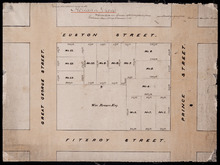
Holland Grove
Description: Plan of the block of land between Euston Street and Fitzroy Street and Prince Street and Great George Street known as Holland Grove. Town Lots 18-22 and 63-67 in the fifth hundred.
Province: Prince Edward Island
Type: cadastral maps
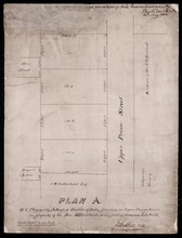
Plan A. Of 4 Pleasantly Situated Building Lots, fronting on Upper Prince Street, The property of…
Description: Plan "A" of four pleasantly situated lots fronting on Upper Prince Street, the property of the Hon. T.H. Haviland, Common Lot No.24. (No.60) more
Province: Prince Edward Island
Type: cadastral maps
Date Created: 1886

Plan of St. Avard's divided into Building Lots part of the Estate of the Honble. James C. Pope…
Description: Plan of St. Avards divided into building lots, part of the estate of the Hon. James C. Pope in the Royalty of Charlottetown. Royalty Lot No.13. Also shown are St. Peters Road, and Mt. Stewart Road.
Province: Prince Edward Island
Type: cadastral maps
Date Created: 1878

Plan showing the situation of part of the Estate of the late Owen Connolly Esq. in Charlottetown…
Description: Plan showing the situation of part of the Estate of the late Owen Connolly in Charlottetown Common and Royalty. Created by John Ball, surveyor, and copied by Thomas W. May. The map shows Malpeque… more
Province: Prince Edward Island
Type: cadastral maps
Date Created: 1921-01
Plan of Lot 41
Description: Plan of Lot 41. Shows names of some residents. The map also shows St. Peters Bay and the Gulf of St. Lawrence.
Province: Prince Edward Island
Type: cadastral maps

Plan of 1390 Acres of Land part of Township No. 65: The property of the Hon,, Smauel Cunard…
Description: Plan of part of Lot 65 (No.172). 1390 acres of land, part of the property of the Hon. Samuel Cunard. One of the plans referred to in the Deed from Sir Edward, William, and Laura Cunard to the… more
Province: Prince Edward Island
Type: cadastral maps
Date Created: 1866-07-13
Plan of Township No. 54: Chiefly from Surveys by Geo. Wright and Rodk. Campbell copied By Owen…
Description: Plan of Lot 54, chiefly from surveys by Geo. Wright and Rod'k Campbell. Copied by Owen Curtis, 1877. Shows names of residents, acreage, and land conveyance references, roads, bodies of water,… more
Province: Prince Edward Island
Type: cadastral maps
Date Created: 1877
Plan of an approximate correction of the Junction of the Maitland road with the Murray Harbour Road…
Description: Plan of an approximate correction of the Junction of the Maitland Road with the Murray Harbour Road as sketched in sundry plans by the late Roderick Campbell... and as measured on the ground on the… more
Province: Prince Edward Island
Type: cadastral maps
Date Created: 1921-09-09