Displaying 55 - 81 of 504
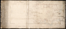
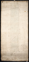
Stanhope Shore Rd.
Description: The map shows the Stanhope Shore Road with the names of residents, their road frontage measurements and dollar amounts for each.
Province: Prince Edward Island
Type: cadastral maps
Date Created: 1954

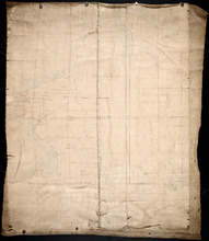
Education: Proposed Consolidation
Description: Map of Prince Edward Island. Education - proposed consolidation. Colored overlay on printed map. The map also shows the Gulf of St. Lawrence, Northumberland Strait, and various bodies of water.
Province: PE
Type: cadastral maps, thematic maps
Date Created: 1967-07
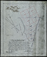
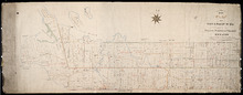
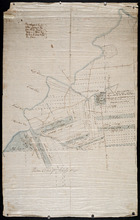
Plan of Webber Creek: being supplementary to "Plan of Richmond Bay from Curtain Island to…
Description: Plan of Webber Creek being supplementary to "Plan of Richmond Bay from Curtain Island to Lockes Shore" showing additional plots Nos. 478B, 478C, 478D, and 478E for Oyster Culture. The map… more
Province: Prince Edward Island
Type: plans
Date Created: 1913-10-08
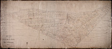
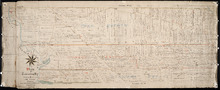
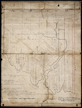
Plan of the Cunard and Palmer Estates in Lot or Township No.1.
Description: Plan of Lot 1 (No.1). Cunard and Palmer Estates. Drawn by Owen Curtis. Shows names of residents, acreage, and a few land conveyance references, and roads.
Province: Prince Edward Island
Type: cadastral maps
Plan of Township No 15: Taken from the survey of William Cutis (1826) wit alterations and…
Description: Plan of Lot 15 (No.42) taken from the survey of William Curtis (1826) with alterations and corrections from surveys made in 1849 and 1851 by Geo. Wright. Color code shows Crown Lands and lands… more
Province: Prince Edward Island
Type: cadastral maps
Date Created: 1851

Plan of Township No. 48: compiled during the year 1915 from plans on file in the Land Office and…
Description: Plan of Lot 48 compiled during the year 1915 from plans on file in the Land Office and Registry Office and from the chart of Charlottetown Harbour supplemented by the descriptions in the leases and… more
Province: Prince Edward Island
Type: cadastral maps
Date Created: 1915

Plan of Township No. 63: compiled from the proprietors' plans, descriptions in leases and…
Description: Plan of Lot 63 compiled from the proprietors' plans, descriptions in leases and registered deeds, and from Meacham's Atlas, with additions and corrections from surveys made at various times… more
Province: Prince Edward Island
Type: cadastral maps
Date Created: 1921-02

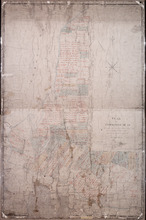
Plan of Township No. 32: compiled from the proprietors plans and Meacham's Atlas and from the…
Description: The map shows Lot 32 divided into parcels of land with names of residents, acreage amounts and land conveyance references. Areas drawn in black indicate government land; areas in red indicate… more
Province: Prince Edward Island
Type: cadastral maps
Date Created: 1919-01
Plan of Lot or Township No. 6 in Prince Edward Island: From Actual Survey by A. Anderson, Land…
Description: Plan of Lot 6. Northern half shows residents.
Province: Prince Edward Island
Type: cadastral maps

Plan of Township No. 57: Compiled from the proprietors plans and Meacham's Atlas, and from the…
Description: The map shows Lot 57 divided into parcels of land with names of residents, acreage amounts and land conveyance references. Areas drawn in black indicate land conveyed to the government and re-… more
Province: Prince Edward Island
Type: cadastral maps
Date Created: 1917
A Plan of Lot 18: situated in Prince County in the Island of St. John enlarged and Drawn from the…
Description: Sketch plan of Lot 18 (Plan No.46) showing property of Peter Stewart, Robert Stewart, and Wm. Allanby. Surveyed by Thomas Wright. Office copy by Jos. Ball and certified by Geo. Wright. Original was… more
Province: Prince Edward Island
Type: cadastral maps
Date Created: 1847-04-06
Plan of the Western Moiety of Township No.20: Grenville Parish, Queens County, P. E. Island
Description: Plan of the Western Moiety of Township No.20, showing residents.
Province: Prince Edward Island
Type: cadastral maps
Date Created: 1850
Plan of Township No. 26: Comprising the Holland, Stephens, and Thomson Estates Copied from the…
Description: Plan of Lot 26 (No.70) comprising the Holland, Stephens, and Thomson Estates copied from the plans in Public Lands Department, corrected by partial surveys and Meacham's Atlas. more
Province: Prince Edward Island
Type: cadastral maps
Date Created: 1885-09
Plan of Township 27: embracing Freeholds and the Pope and Cunard Estates. Compiled from Meacham…
Description: Plan of Lot 27 (No.73) embracing freeholds and the Pope and Cunard Estates. Compiled from Meacham's Atlas and the original leases. more
Province: Prince Edward Island
Type: cadastral maps
Date Created: 1885-09
A Plan of the Northern half Lot or Township No. 27 in Prince Edward Island: from an Actual Survey…
Description: Outline plan of northern half of Lot 27 (No.2).
Province: Prince Edward Island
Type: cadastral maps
Date Created: 1818
Eastern Division of Township No. 28
Description: Sketch of the eastern division of Lot 28 (No.33). DeBlois Estate.
Province: Prince Edward Island
Type: cadastral maps
Date Created: 1870-01-01

Plan of Township No. 29: embracing the Fane and Melville Estates – 1883
Description: Plan of Lot 29 (No.80). Fane and Melville Estates.
Province: Prince Edward Island
Type: cadastral maps
Date Created: 1883

Plan of Township 30
Description: Plan of Lot 30 (No.82). Stewart Estate. Shows names of residents.
Province: Prince Edward Island
Type: cadastral maps
Lot 31: Southern portion
Description: Plan of the southern part of Lot 31, showing residents. In use 1819. From H.J. Cundall.
Province: Prince Edward Island
Type: cadastral maps

Lot 32
Description: Plan of Lot 32 showing some residents.
Province: Prince Edward Island
Type: cadastral maps

Plan of Township No. 33 in Prince Edward Island: Part of the Estate of John Hodges Winsloe Esq.…
Description: Plan of Lot 33. Winsloe Estate.
Province: Prince Edward Island
Type: cadastral maps
Date Created: 1834-09-20

Lot 34: Southern portion
Description: Part of Lot 34 (No.7). North side of Hillsborough River.
Province: Prince Edward Island
Type: cadastral maps

Plan of Lot 38
Description: Plan of Lot 38 showing the extent of land in possession of the Government...(?)
Province: Prince Edward Island
Type: cadastral maps

Plan of Lot or Township No. 39: from the lastest Surveys by Joseph Ball, S.G., July 1, 1857
Description: Plan of Lot 39 (No.104). Worrell Estate. Plan copied by Owen Curtis, 1876.
Province: Prince Edward Island
Type: cadastral maps
Date Created: 1857-07-01

Plan of Lot or Township No. 40: From latest Surveys by Joseph Ball and Owen Curtis, Land Surveyors.
Description: Plan of Lot 40 (No.109). Worrell Estate.
Province: Prince Edward Island
Type: cadastral maps

Plan of Lot or Township No. 41: From The Latest Surveys By Joseph Ball S.G., Copied by O. Curtis
Description: Plan of Lot 41 (No.111). Showing residents. Surveyed by Joseph Ball. Plan copied by Owen Curtis.
Province: Prince Edward Island
Type: cadastral maps

Lot 43: No. 1
Description: Plan of Lot 43 (No.1), showing Bay Fortune, Rollo Bay and North Shore areas.
Province: Prince Edward Island
Type: cadastral maps