Displaying 55 - 81 of 118
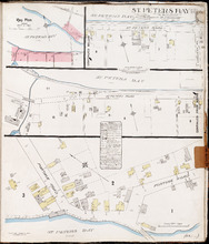
St. Peters Bay P.E.I., Kings Co.: Population 250. No Protection. Octr. 1910
Description: This is a fire insurance plan of the community of St. Peter's Bay that consists of three (3) parts: two maps, one of which is shown in two sections that are meant to be continuous. The largest… more
Publisher: Chas. E. Goad, Civil Engineer
Province: Prince Edward Island
Type: fire insurance maps
Date Created: 1910-10
Date Issued (Source): 1888

Summerside Prince Edward Island: Population: 3,500. July 1903
Description: This item, the first of 11 pages of fire insurance maps of Summerside, serves as the key plan for the other Summerside pages. It was created in 1903, revised to 1910, and then revised again to August… more
Publisher: Chas. E. Goad, Civil Engineer
Province: Prince Edward Island
Type: fire insurance maps
Date Created: 1903-07
Date Modified: 1910-10, 1917-08
Date Issued (Source): 1888

Summerside P.E.I.: Aug. 1917. Reprinted.
Description: This is Page 2 of 11 pages of fire insurance maps of Summerside. It shows the area from Market Street North to the waterfront, between Duke and Central streets. The map shows numbered town blocks and… more
Publisher: Chas. E. Goad, Civil Engineer
Province: Prince Edward Island
Type: fire insurance maps
Date Created: 1917-08
Date Issued (Source): 1888

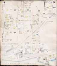
Summerside, P.E.I.: Oct. 1910. Reprinted
Description: This is the older (1910) version of Page 3 of the Summerside fire insurance maps. The updated map of this town section is shown on Summerside_p3_1917. This map shows the area from Church Street to… more
Publisher: Chas. E. Goad, Civil Engineer
Province: Prince Edward Island
Type: fire insurance maps
Date Created: 1910-10
Date Issued (Source): 1888

Summerside P.E.I.: Aug 1917. Reprinted
Description: This is Page 3 of 11 pages of fire insurance maps of Summerside. This map shows the area from Church Street to the waterfront, between Central and Granville streets. The map shows numbered town… more
Publisher: Chas. E. Goad, Civil Engineer
Province: Prince Edward Island
Type: fire insurance maps
Date Created: 1917-08
Date Issued (Source): 1888

Summerside P.E.I.: July 1903.
Description: This is the older (1903, updated to 1910) version of Page 4 of the Summerside fire insurance maps. A more updated map of this town section is shown on Summerside_p4_1917. This map shows the area from… more
Publisher: Chas. E. Goad, Civil Engineer
Province: Prince Edward Island
Type: fire insurance maps
Date Created: 1903-07
Date Modified: 1910
Date Issued (Source): 1888

Summerside, P.E.I.: Aug. 1917. Reprinted
Description: This is Page 4 of 11 pages of fire insurance maps of Summerside. (An older version of this town section is shown on Summerside_p4_1910.) The map shows the area from Belmont Street to the waterfront,… more
Publisher: Chas. E. Goad, Civil Engineer
Province: Prince Edward Island
Type: fire insurance maps
Date Created: 1917-08
Date Issued (Source): 1888
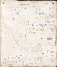
Summerside, P.E.I.: July 1903
Description: This is Page 5 of 11 pages of fire insurance maps of Summerside. It was created in 1903 and revised to 1910. It shows the area from Myrtle Street to Market Street North, between Duke and Central… more
Publisher: Chas. E. Goad, Civil Engineer
Province: Prince Edward Island
Type: fire insurance maps
Date Created: 1903-07
Date Modified: 1910
Date Issued (Source): 1888
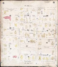
Summerside P.E.I.: July 1903.
Description: This is Page 6 of 11 pages of fire insurance maps of Summerside. It was created in 1903 and revised to 1910. It shows the area from Convent Street to Church Street, between Central and Granville… more
Publisher: Chas. E. Goad, Civil Engineer
Province: Prince Edward Island
Type: fire insurance maps
Date Created: 1903-07
Date Modified: 1910
Date Issued (Source): 1888
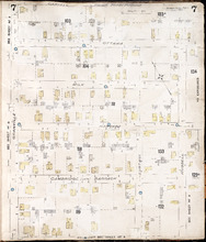
Summerside P.E.I.: July 1903.
Description: This is Page 7 of 11 pages of fire insurance maps of Summerside. It was created in 1903 and revised to 1910. It shows the area from Carvell Street to Belmont Street, between Granville and Russell… more
Publisher: Chas. E. Goad, Civil Engineer
Province: Prince Edward Island
Type: fire insurance maps
Date Created: 1903-07
Date Modified: 1910
Date Issued (Source): 1888
Summerside, P.E.I.: July 1903
Description: This is Page 8 of 11 pages of fire insurance maps of Summerside. It was created in 1903 and revised to 1917. It shows an area from the Kirk Street vicinity to the waterfront, east of Russell Street.… more
Publisher: Chas. E. Goad, Civil Engineer
Province: Prince Edward Island
Type: fire insurance maps
Date Created: 1903-07
Date Modified: 1917-08 (year and month uncertain)
Date Issued (Source): 1888
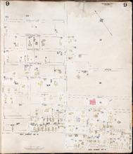
Summerside, P.E.I.: July 1903
Description: This is Page 9 of 11 pages of fire insurance maps of Summerside. It was created in 1903 and revised to either 1910 or 1917. It shows the area from Chestnut Avenue, in the north, to Myrtle and Convent… more
Publisher: Chas. E. Goad, Civil Engineer
Province: Prince Edward Island
Type: fire insurance maps
Date Created: 1903-07
Date Modified: 1910 (year uncertain)
Date Issued (Source): 1888

Tignish. P.E.I.: Population 500. No appliances. October 1888
Description: This is an older (1888, revised to 1893) version of a fire insurance plan of the village of Tignish. A more updated plan is shown on the map Tignish_1910. The map shows the area near Chapel Road and… more
Publisher: Chas. E. Goad, Civil Engineer
Province: Prince Edward Island
Type: fire insurance maps
Date Created: 1888-10
Date Modified: 1893-10
Date Issued (Source): 1888
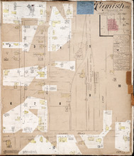
Tignish P.E.I.: Population: 500. Hook & Ladder. Nov 1897.
Description: This is a fire insurance plan of the village of Tignish. It was created in 1897 and revised to 1910. (An older plan is shown on the map Tignish_1893.) The map shows the area near Chapel Road and the… more
Publisher: Chas. E. Goad, Civil Engineer
Province: Prince Edward Island
Type: fire insurance maps
Date Created: 1897-11
Date Modified: 1910-10
Date Issued (Source): 1888
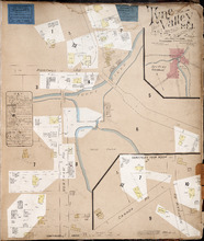
Tyne Valley P.E.I.: Novr. 1897. 1 Mile West of Port Hill Station. Population 300. No Appliances.…
Description: This is a fire insurance plan of Tyne Valley. It was created in 1897, revised to 1903, and then revised again to October, 1910. It shows the town in two (2) sections that are intended to be… more
Publisher: Chas. E. Goad, Civil Engineer
Province: Prince Edward Island
Type: fire insurance maps
Date Created: 1897-11
Date Modified: 1903-07, 1910-10
Date Issued (Source): 1888

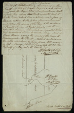
Vernon River Bridge, Lot 50
Description: This item consists of a fire insurance plan of the community of Vernon River Bridge and an accompanying handwritten text document. The map of Vernon River shows the community divided into numbered… more
Province: Prince Edward Island
Type: fire insurance maps
Date Issued (Source): 1888
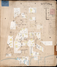
Victoria P.E.I.: Population 300. No appliances. Chas E Goad Civil Engineer Toronto & Montreal.…
Description: This is a fire insurance plan of the village of Victoria. It was created in 1893 and revised to October, 1910. It shows the area from Bardin Street to the waterfront, between Nelson and Russell… more
Publisher: Chas. E. Goad, Civil Engineer
Province: Prince Edward Island
Type: fire insurance maps
Date Created: 1893-10
Date Modified: 1910-10
Date Issued (Source): 1888
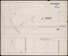
Wellington, Lot 16
Description: This item is a fire insurance plan of the community of Wellington. It shows the village in three (3) sections that are intended to be continuous. The largest map section, across the top of the sheet… more
Province: Prince Edward Island
Type: fire insurance maps
Date Issued (Source): 1888
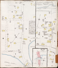
Murray River South P.E.I., Kings Co.: Population 300. No Protection. Oct 1910
Description: This is a fire insurance plan of the community of Murray River South that consists of two maps--one for each side of the Murray River. The larger map, on the left side of the page, shows an area of… more
Publisher: Chas. E. Goad, Civil Engineer
Province: Prince Edward Island
Type: fire insurance maps
Date Created: 1910-10
Date Issued (Source): 1888

Plan of Lot 23
Description: Plan of Lot 23. Shows names of residents in central portion of Lot, i.e. around Clyde River.
Province: Prince Edward Island
Type: cadastral maps

Plan of that part of Township Number Forty-nine, in Prince Edward Island, the Property of the Hon.…
Description: Plan of part of Lot 49, the property of the Hon. Edward C. Haythorne and Robert Poore Haythorne. Tracts shaded green sold with the Act 28 Vic. Cap.5. (No.133). Shows names of residents and acreage,… more
Province: Prince Edward Island
Type: cadastral maps
Date Created: 1857-01

A Plan of Ronald McDonalds Land of Grand Tracadie For The Surveyors Generals Office
Description: Plan of part of Lot 35 (No. 5). The map shows 175 acres of land belonging to Ronald McDonald at Grand Tracadie in the northern part of Lot 35. The map shows the names of the residents on either side… more
Province: Prince Edward Island
Type: cadastral maps
Date Created: 1824-08-03

Plan Shewing the situation of the respective Fishing Establishments, Fronting Harris or Rustico Bay…
Description: Plan of part of Lot 24. Shows situation of the fishing establishments fronting Harris or Rustico Bay. From actual survey. The map shows the Harbours Mouth and Robinsons Island.
Province: Prince Edward Island
Type: cadastral maps
Date Created: 1869-09-02

Alberton, Prince Edward Island: Population 1500. Hand Engine. 400' Hose. Water Supply: Brook…
Description: This is a fire insurance plan of the town of Alberton concentrating on two blocks of Main Street from Church Street to Argyle Street. A key plan in the lower left corner provides context. The map was… more
Publisher: Chas. E. Goad, Civil Engineer
Province: Prince Edward Island
Type: fire insurance maps
Date Created: 1888-10
Date Modified: 1910-10
Date Issued (Source): 1888

Annandale, Lot 65
Description: This item may be a draft of a fire insurance plan of the community of Annandale. The map, drawn on a grid, in pencil, shows the area of Main Street and Lorne Street. It shows buildings, but they are… more
Province: Prince Edward Island
Type: fire insurance maps
Date Created: 1845
Date Issued (Source): 1888
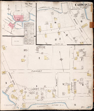
Cardigan P.E.I., Kings Co.: Population 300. No Protection. Oct. 1910
Description: This is a fire insurance plan of the village of Cardigan consisting of two maps--one for each side of the Cardigan River. A key plan in the upper left corner provides context. The map on the upper… more
Publisher: Chas. E. Goad, Civil Engineer
Province: Prince Edward Island
Type: fire insurance maps
Date Created: 1910-10
Date Issued (Source): 1888
Date Modified (Source): 1910-10, 1917-10