Displaying 379 - 405 of 504
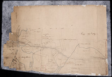
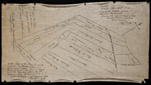
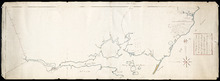
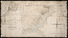
Paln No. 1 of Railway Appropriation: from Alberton to Tignish
Description: Plan of Railway Appropriations from Alberton to Tignish. (Plan No.1). The map shows roads, resdients, acreage, lots, and foliage.
Province: Prince Edward Island
Type: cadastral maps
Date Created: 1873
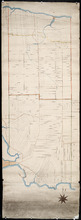
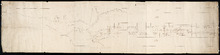
Plan No. 2 of Railway Appopriation: From Alberton to Tignish
Description: Plan of Railway Appropriations from Alberton to Tignish. (Plan No.2). The map shows roads, lots, residents, acreage, and foliage.
Province: Prince Edward Island
Type: cadastral maps
Date Created: 1873

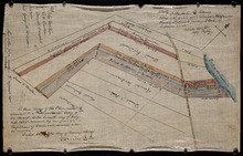
Plan of part of the Railway appropriations in Lot 45: Harmony Station
Description: Plan of part of the Railway appropriations in Lot 45. Harmony Station. The map shows roads, residents and acreage.
Province: Prince Edward Island
Type: cadastral maps
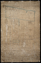
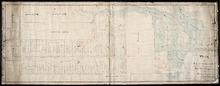
Plan of Lot No. 38 [? title partly missing]
Description: Plan of part of Lot 38 and part of Lot 39. Savage Harbour area. The map shows northern portions of Lot 38 and Lot 39 divided into parcels of land with names of residents and acreage amounts. It shows… more
Province: Prince Edward Island
Type: cadastral maps
Untitled
Description: Unfinished plan of Lot 45. The map shows some lots, residents, and bodies of water.
Province: Prince Edward Island
Type: cadastral maps

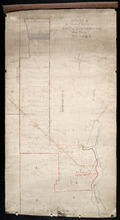
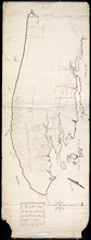
Lot No. 46
Description: Plan of Lot 46 (No.1) divided into two parts and drawn for in Council, Oct. 24, 1786. The map shows Lot 46 divided into two parts--Division No. 1 (west) and Division No. 2 (east)--of 10,000 acres… more
Province: Prince Edward Island
Type: cadastral maps
Date Created: 1786-10-24
Plan of the Northern Moiety of Lot 45: compiled from surveys made by L.N. Gall and H.J. Cundall.
Description: Plan of the northern moiety of Lot 45 compiled from surveys made by L.N. Gall and H.J. Cundall. Plan referred to in deed to Commissioner of Public Land, dated 13th July, 1866. The map of the northern… more
Province: Prince Edward Island
Type: cadastral maps
Date Created: 1866
Plan of part of Lot 47: The Estate of the late Alexander McDonald showing allotments pursuant to…
Description: Plan of part of Lot 47. The estate of the late Alexander McDonald showing allotments pursuant to Order of Supreme Court Schedule G. The map shows the estate of the late Alexander McDonald divided… more
Province: Prince Edward Island
Type: cadastral maps
Date Created: 1885-07-07
Plan of part of Lot 47: The estate of the late Alexander McDonald showing the different kinds of…
Description: Plan of part of Lot 47. The estate of the late Alexander McDonald showing the different kinds of land. Schedule F. The map, drawn in black ink, shows the estate of the late Alexander McDonald divided… more
Province: Prince Edward Island
Type: cadastral maps
Date Created: 1885-07-07

Plan of the Northern Moiety of Lot or Township No. 48 in Prince Edward Island, Copied from the Plan…
Description: Plan of the northern moiety of Lot 48 (No.129). Shows the property of Miss Frances Crooke, R.G. Cuninghame, Theo. Desbrisay, and the Misses Lawton. The map shows lots, residents, roads, and bodies of… more
Province: Prince Edward Island
Type: cadastral maps
Date Created: 1836

Plan of Township No. 50 The Estate of the Misses[?] Fanning, Prince Edward Island: From actual…
Description: Plan of Lot 50. Fanning Estate. The map shows lots, residents, bodies of water and roads.
Province: Prince Edward Island
Type: cadastral maps

A Plan of the Eastern or C Division of Lot or Township No. 51: St. Georges Parish, Kings Coutnry, P…
Description: Plan of the eastern division of Lot 51. Montgomery Estate. The map shows the C Division of Lot 51 divided into numbered parcels of land with the names of owners or occupants with their corresponding… more
Province: Prince Edward Island
Type: cadastral maps

Plan of Lot or Township No. 51 in Kings County Prince Edward Island: Surveyed by G. Wright Jr. in…
Description: Plan of Lot 51 (No.141). Shows residents, lots, bodies of water such as rivers, and roads.
Province: Prince Edward Island
Type: cadastral maps
Date Created: 1836

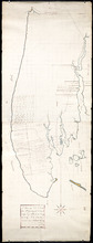
Plan of Lot 57
Description: Plan of Lot 57 (No.2) showing the lot divided into quarters. Also shows Refugee Share drawn for in Council, 12 February, 1784.
Province: Prince Edward Island
Type: cadastral maps
Date Created: 1784-02-12

A Plan of the undisposed of Parts of Lot No. 57: in Queens County in Prince Edward Island
Description: A plan of the undisposed of parts of Lot 57. Surveyed by Rod'k Campbell. The map shows parcels of land with names of owners or occupants and their corresponding acreage amounts handwritten in… more
Province: Prince Edward Island
Type: cadastral maps
Date Created: 1860
Plan of Lot 58
Description: Plan of Lot 58 divided into four sections. Shows Refugee Shares drawn for 12th February, 1784. Shown are lots, residents, and bodies of water.
Province: Prince Edward Island
Type: cadastral maps
Date Created: 1784-02-12

A Plan of the undisposed of Part, of Lot No. 38 in Queens County in Prince Edward Island
Description: A plan of the undisposed part of Lot 58 (No.154). Shows residents, lots, roads, and water. Surveyed by Rod'k Campbell. more
Province: Prince Edward Island
Type: cadastral maps
Date Created: 1860
Plan of Lot or Township No 59: Two Thirds being the property of The Messrs Montgimeries being 13,…
Description: Plan of Lot 59 (No.157). Two thirds being the property of the Messrs. Montgomeries being 13,064 acres. One third, the property of Earl Selkirk. Plan copied by Jas. J. Bevan. Date of plan: April 1848… more
Province: Prince Edward Island
Type: cadastral maps
A Plan of the North or C Division of Lot or Township No. 59: Kings County, P. E. Island
Description: A plan of the north division of Lot 59 (No.159). James Montgomery Estate. The map shows the C Division of Lot 59 divided into numbered parcels of land with the names of occupants and their… more
Province: Prince Edward Island
Type: cadastral maps

Plan of Lot or Township No 59 Two Thirds being the property of Sir James Montgomery Brothers being…
Description: Plan of Lot 59. Two thirds being the property of Sir James Montgomery & Brothers, and one third the property of Earl Selkirk. The map shows bodies of water such as rivers, residents, lots, and… more
Province: Prince Edward Island
Type: cadastral maps
Date Created: 1842-03-01
Lot 50
Description: Plan of Lot 63 (No.2). The property of J. Cambridge. Mainly outline. Shows a few residents, lots, bodies of water, islands, and roads.
Province: Prince Edward Island
Type: cadastral maps
Date Created: 1829-04

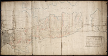
Plan of Township No 63, St. Andrews Parish Kings County: Prince Edward Island
Description: Plan of Lot 63. Eastern part shows names of residents, lots, acreage, bodies of water such as rivers, and bays, and roads.
Province: Prince Edward Island
Type: cadastral maps
Date Created: 1842

Plan of Township No 63 St. Andrew's Parish Queens County: P.E.Island
Description: Plan of Lot 63. This is one of the plans referred to in the Deed from the Cunards to the Commissioner of Public Lands, July 15, 1866. The map shows lots, residents, roads, acreage and bodies of water… more
Province: Prince Edward Island
Type: cadastral maps
Date Created: 1851
A Plan of Lot No 64: The property of J. Cambridge Esq Situate in Kings County P.E.Island
Description: Plan of Lot 64. The property of J. Cambridge. Shows some residents. Copy by James Richard. The map shows lots, residents, roads, cities, towns, and bodies of water.
Province: Prince Edward Island
Type: cadastral maps
Date Created: 1829-03
A Plan of Lot No. LXIV: The Property of J. Cambridge Esqr. Situate in Kings County P. E. Island…
Description: Plan of Lot 64 (No. 2). The property of J. Cambridge. The map shows Lot 64 partially divided into parcels of land with the names of residents and their acreage amounts. The map shows roads, which are… more
Province: Prince Edward Island
Type: cadastral maps
Date Created: 1829-03
Plan of Half Township No. 65 One of the Estates of the Misses Fanning - Prince Edward Island: From…
Description: Plan of the eastern half of Lot 65 (No. 175). The Misses Fanning Estate. The map shows lots, residents, roads, and bodies of water such as rivers.
Province: Prince Edward Island
Type: cadastral maps
Plan of the Western Portion of Township No. 65: containing 5250 acres and belonging to Mrs. Lydia…
Description: Plan of the western portion of Lot 65 (No.173). Estate of Mrs Lydia Wright. Roads, leased land[?] and freehold land on the Estate of Mrs. Lydia Wright. Tenant names appear on the sub-lots, which are… more
Province: Prince Edward Island
Type: cadastral maps
Date Created: 1841