Displaying 1 - 54 of 67
Plan of Richmond Bay from Curtain Island to Malpeque Wharf: Showing location of Oyster Beds and…
Description: Plan of Richmond Bay from Curtain Island to Malpeque Wharf showing location of Oyster Beds and subdivision for leasing purposes. (No.3) The map shows residents, lots, measurements, and islands.
Province: Prince Edward Island
Type: cadastral maps
Date Created: 1912-10-14
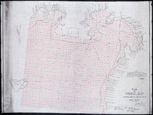
Plan of Pownal Bay: showing the subdivisions to be leased for Oyster Culture
Description: Plan of Pownal Bay showing the subdivisions to be leased for Oyster Culture. (No.13) The map shows residents, lots, measurements, and islands.
Province: Prince Edward Island
Type: cadastral maps
Date Created: 1914

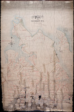
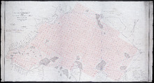
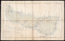
Plan of Richmond Bay from Curtain Island to Locke Shore : Showing location of Oyster Beds and…
Description: Plan of Richmond Bay from Curtain Island to Locke Shore showing location of Oyster Beds and subdivisions for leasing purposes. (No.1) The map shows residents, lots, measurements, islands, and rivers.
Province: Prince Edward Island
Type: cadastral maps
Date Created: 1912-10-14
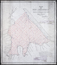
Plan of New London Bay: Showing Sub-divisions to be leased for Oyster Culture
Description: Plan of New London Bay showing sub-divisions to be leased for Oyster Culture. (No.9) The map shows residents, lots, measurements, and sand hills.
Province: Prince Edward Island
Type: cadastral maps
Date Created: 1914

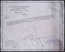
Plan of Cascumpec Bay: Showing Sub-divisions to be leased for Oyster Culture
Description: Plan of Cascumpec Bay showing sub-divisions to be leased for Oyster Culture. (No.8) The map shows residents, measurements, lots, rivers, and sand hills.
Province: Prince Edward Island
Type: cadastral maps
Date Created: 1913-11-17
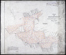
Plan of Bedeque Bay : Showing Sub-divisions to be leased for Oyster Culture
Description: Plan of Bedeque Bay showing sub-divisions to be leased for Oyster Culture. (No.16) The map shows residents, lots, measurements, and Holman's Island. more
Province: Prince Edward Island
Type: cadastral maps
Date Created: 1914-06-01
Plan of Narrows at Cranberry Point: showing subdivisions to be leased for Oyster Culture
Description: Plan of Narrows at Cranberry Point (between Cascumpeque and Richmond Bays) showing subdivisions to be leased for Oyster Culture. (No.15). The map shows residents, measurements, sand hills, and a… more
Province: Prince Edward Island
Type: cadastral maps
Date Created: 1914-09-01
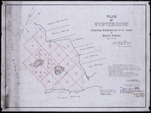
Plan of Oyster Cove: showing subdivisions to be leased for Oyster Culture
Description: Plan of Oyster Cove showing subdivisions to be leased for Oyster Culture. (No.6). The map shows redisents, measurements, and Richmond Bay.
Province: Prince Edward Island
Type: cadastral maps
Date Created: 1913-08-15
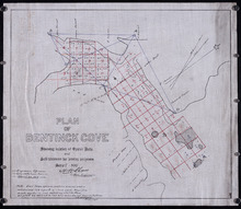
Plan of Bentinck Cove: Showing location of Oyster Beds and subdivisions for leasing purposes/
Description: Plan of Bentinck Cove showing location of Oyster Beds and subdivisions for leasing purposes. (No.4) The map shows lots, residents, and measurements of those lots.
Province: Prince Edward Island
Type: cadastral maps
Date Created: 1913-03-20

Lot 6: No. 19
Description: Plan of Lot 6 (No. 19). Cunard Estate. Shows names of residents, acreage, and some land conveyance references, bodies of water such as rivers, and roads.
Province: Prince Edward Island
Type: cadastral maps
Plan of Township No. 11 in Prince Edward Island: Surveyed by A. Anderson Land Surveyor
Description: Plan of Lot 11 (No. 32). Stewart Estate. Shows names, acreage, and land conveyance references for some residents, bodies of water such as coves, rivers, roads, and a nautical compass.
Province: Prince Edward Island
Type: cadastral maps
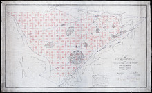
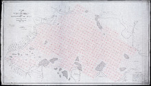
Plan of Richmond Bay from Grand River to Malpeque Harbour: showing location of Oyster Beds and…
Description: Plan of Richmond Bay from Grand River to Malpeque Harbour showing location of Oyster Beds and subdivisions for leasing purposes. (No.2) The map shows resdients, lots, measurements, islands, rivers,… more
Province: Prince Edward Island
Type: cadastral maps
Date Created: 1912-10-14
Plan of Richmond Bay from Grand River to Malpeque Harbour: Showing location of Oyster Beds and…
Description: Plan of Richmond Bay from Grand River to Malpeque Harbour showing location of Oyster Beds and subdivisions for leasing purposes. (No.2) The map shows residents, lots, measurements, islands, ponds and… more
Province: Prince Edward Island
Type: cadastral maps
Date Created: 1912-10-14

Plan of Township No. 33 in Prince Edward Island: Part of the Estate of John Hodges Winsloe Esq.…
Description: Plan of Lot 33. Winsloe Estate.
Province: Prince Edward Island
Type: cadastral maps
Date Created: 1834-09-20

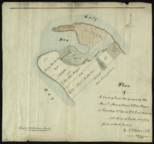
Lot 43: No. 1
Description: Plan of Lot 43 (No.1), showing Bay Fortune, Rollo Bay and North Shore areas.
Province: Prince Edward Island
Type: cadastral maps

Plan of Township No. 64: St. Andrews Parish, Queens County, P. E. Island
Description: Lot 64 is situated in Kings County, not Queens County as stated in the map title. The map shows Lot 64 divided into parcels of land with names of residents and their acreage amounts. Several parcels… more
Province: Prince Edward Island
Type: cadastral maps
Date Created: 1850

Plan of Lot or Township No. 34
Description: Plan of Lot 34 (No. 90). Montgomery Estate. Working plan. The map shows Lot 34 divided into parcels of land with the names of residents and their acreage amounts handwritten in black ink. Land… more
Province: Prince Edward Island
Type: cadastral maps
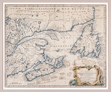
A New and Accurate Map of the Islands of Newfoundland, Cape Briton, St. John and Anticosta:…
Description: Map, showing the Maritime provinces; the vertical fold indicates that it originally appeared in a book or atlas; cartouche in bottom right corner. Port Joy is the only settlement named on Isle St.… more
Publisher: Astron Obervat
Province: Nova Scotia, Newfoundland, Cape Breton, St. John, Anticosta
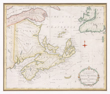
A New and Accurate Map of the Province of Nova Scotia, in North America, From the Latest…
Description: Framed map of the province of Nova Scotia and vicinity. The map shows bodies of water such as the Gulf of St. Lawrence and Bay of Fundy, towns, cities, villages, islands, banks, and a compass rose.
Province: Nova Scotia
Type: topographic maps, pictorial maps
Date Created: 1773

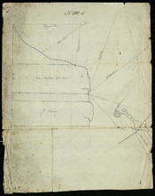
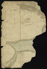
Plan Shewing the position of the Northern points of Commencement of the Lines dividing Lots 33 and…
Description: The map shows northern portions of Lots 24, 33, 34 and 35 along the north shore of Prince Edward Island. It shows the northern-most sections of three boundary lines: the line dividing Lots 24 and 33… more
Province: Prince Edward Island
Type: chorographic maps
Date Created: 1835-05-07

Plan of Township No. 64: compiled from the proprietors' plans, descriptions in leases and…
Description: The map shows Lot 64 divided into parcels of land with names of residents, their acreage amounts and land conveyence references. Land information written in black indicates government land;… more
Province: Prince Edward Island
Type: cadastral maps
Date Created: 1920
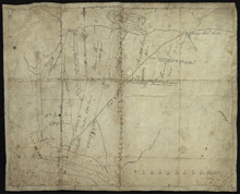
Plan of Île Saint-Jean: The Island of Saint John
Description: Plan of Ile Saint-Jean / the Island of Saint John. The map shows Prince Edward Island and a portion of the mainland. It identifies settlements, bays, harbours, rivers and islands. Sandy areas are… more
Province: Prince Edward Island
Type: topographic maps
Date Created: 1760
Entrance to the Croppo River
Description: Plan of part of Lot 29 (No.4). Entrance to Croppo River. Shows soundings at Crapaud Harbour. The map shows the harbour and entrance to the Crapaud (or Westmoreland) River. Soundings appear to be… more
Province: Prince Edward Island
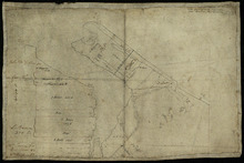
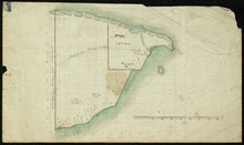
Part of Lot 33: Area around Rustico Bay
Description: Plan of part of Lot 33. Area around Rustico Bay. The map shows the area around Rustico Bay in the northwest part of Lot 33. It shows the land divided into parcels with names of some residents and… more
Province: Prince Edward Island
Type: cadastral maps
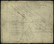
Parts of Lot 33: Two maps showing the northern extremities of the east and west boundaries of Lot 33
Description: Plans of two parts of Lot 33 (No.4): McMillan's Point; Grand Pere Point. This item consists of 2 maps on one sheet--one each on the front and back. Side One shows McMillan Point on Covehead Bay… more
Province: Prince Edward Island
Type: boundary maps
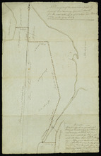
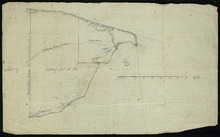
Part of Lot 34
Description: Plan of part of Lot 34 (No.5). Shows properties of John Millar, L. Brown, Neil Shaw, Murdock McCloud, and John Crabtree. The map shows the northwestern portion of Lot 34 divided into parcels of land… more
Province: Prince Edward Island
Type: cadastral maps
Part of Lot 34
Description: Plan of part of Lot 34 (No.3). Area around Covehead Bay. The map shows the northwestern portion of Lot 34, divided into parcels of land with the names of residents and/or proprietors and their… more
Province: Prince Edward Island
Type: cadastral maps
Part of Lot 34
Description: Plan of part of Lot 34 (No.6). Area around Covehead Bay. The map shows the northwestern portion of Lot 34 divided into parcels of land with the names of residents and/or proprietors and their acreage… more
Province: Prince Edward Island
Type: cadastral maps
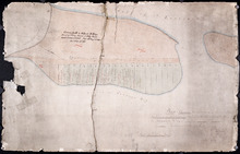
A Draugth of the new road opened by order of his Excellency Governor Smith, for the west settlement…
Description: Plan of part of Lot 34 (No.41). This plan shows a new road in the Covehead area in the northwest corner of Lot 34. It describes the land surrounding the road with labels noting swamp or hardwood… more
Province: Prince Edward Island
Type: engineering maps
Date Created: 1824
Plan of A tract of Land the property the Messrs. Macmillans & Peter Higgins on Township No. 34…
Description: Plan of part of Lot 34 (No. 182). The map shows a parcel of land 111 acres in size belonging to Angus MacMillan, Peter Higgins and Alexander MacMillan near the entrance to Covehead Harbour and what… more
Province: Prince Edward Island
Type: cadastral maps
Date Created: 1854
Plan Shewing the front of Lots No.s 36 & 37
Description: Office copy from the original survey of Prince Edward Island showing the front of Lots 36 and 37. (No.3) The map shows the northern-most portions of Lots 36 and 37 on the north shore, east of… more
Province: Prince Edward Island
Type: boundary maps
Date Created: 1840-09-11
Part of Lot 38
Description: Plan of part of Lot 38 (No. 8). Coffin property. 220 acres of land bordering on Savage Harbour. The map shows the northwestern-most part of Lot 38 that is separated from the rest of the lot by Savage… more
Province: Prince Edward Island
Type: cadastral maps
Part of Lot No. 38
Description: Plan of part of Lot 38 (No. 8), Coffin property. 220 acres of land bordering on Savage Harbour. The map shows the northwestern-most part of Lot 38 that is separated from the rest of the lot by Savage… more
Province: Prince Edward Island
Type: cadastral maps
Part of Lot 38: No. 13
Description: Plan of part of Lot 38 (No.13). 900 acres, the property of Alex Watts. Part of plan is missing. The map shows a 900-acre parcel of land belonging to Alexander Watts Esqr. in the northwestern corner… more
Province: Prince Edward Island
Type: cadastral maps
Part of Lot 38: No. 14
Description: Plan of part of Lot 38 (No. 14). Capt. Bentinck's land. The map shows a parcel of land belonging to Captain Bentinck, north of the Hillsborough River in Lot 38. It gives names of residents and… more
Province: Prince Edward Island
Type: cadastral maps
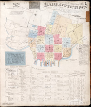
Charlottetown P.E.I.: July 1917. Reprinted.
Description: This is Page 20 of 20 pages of fire insurance maps of Charlottetown. It shows Water Street in two (2) sections that are intended to be continuous. The section at the top of the page shows Water… more
Publisher: Chas. E. Goad, Civil Engineer
Province: Prince Edward Island
Type: fire insurance maps
Date Created: 1917-07
Date Issued (Source): 1888
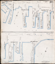
Georgetown P.E.I.
Description: This is the first of two pages of fire insurance maps of Georgetown. It was created in 1888, revised to 1897, and revised again to 1910. This page concentrates on an area one and a half blocks west… more
Publisher: Chas. E. Goad, Civil Engineer
Province: Prince Edward Island
Type: fire insurance maps
Date Created: 1888-10
Date Modified: 1897-11, 1910-09
Date Issued (Source): 1888
Georgetown P.E.I.: Oct. 1893
Description: This is the second of two (2) pages of fire insurance maps of Georgetown. It was created in 1893 and revised to 1910. The map concentrates on an area one and a half blocks east from West Street,… more
Publisher: Chas. E. Goad, Civil Engineer
Province: Prince Edward Island
Type: fire insurance maps
Date Created: 1893-10
Date Modified: 1910-09
Date Issued (Source): 1888
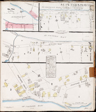
St. Peters Bay P.E.I., Kings Co.: Population 250. No Protection. Octr. 1910
Description: This is a fire insurance plan of the community of St. Peter's Bay that consists of three (3) parts: two maps, one of which is shown in two sections that are meant to be continuous. The largest… more
Publisher: Chas. E. Goad, Civil Engineer
Province: Prince Edward Island
Type: fire insurance maps
Date Created: 1910-10
Date Issued (Source): 1888

Summerside Prince Edward Island: Population: 3,500. July 1903
Description: This item, the first of 11 pages of fire insurance maps of Summerside, serves as the key plan for the other Summerside pages. It was created in 1903, revised to 1910, and then revised again to August… more
Publisher: Chas. E. Goad, Civil Engineer
Province: Prince Edward Island
Type: fire insurance maps
Date Created: 1903-07
Date Modified: 1910-10, 1917-08
Date Issued (Source): 1888

Summerside P.E.I.: Aug. 1917. Reprinted.
Description: This is Page 2 of 11 pages of fire insurance maps of Summerside. It shows the area from Market Street North to the waterfront, between Duke and Central streets. The map shows numbered town blocks and… more
Publisher: Chas. E. Goad, Civil Engineer
Province: Prince Edward Island
Type: fire insurance maps
Date Created: 1917-08
Date Issued (Source): 1888

Summerside, P.E.I.: Oct. 1910. Reprinted
Description: This is the older (1910) version of Page 3 of the Summerside fire insurance maps. The updated map of this town section is shown on Summerside_p3_1917. This map shows the area from Church Street to… more
Publisher: Chas. E. Goad, Civil Engineer
Province: Prince Edward Island
Type: fire insurance maps
Date Created: 1910-10
Date Issued (Source): 1888

Summerside P.E.I.: Aug 1917. Reprinted
Description: This is Page 3 of 11 pages of fire insurance maps of Summerside. This map shows the area from Church Street to the waterfront, between Central and Granville streets. The map shows numbered town… more
Publisher: Chas. E. Goad, Civil Engineer
Province: Prince Edward Island
Type: fire insurance maps
Date Created: 1917-08
Date Issued (Source): 1888

Summerside P.E.I.: July 1903.
Description: This is the older (1903, updated to 1910) version of Page 4 of the Summerside fire insurance maps. A more updated map of this town section is shown on Summerside_p4_1917. This map shows the area from… more
Publisher: Chas. E. Goad, Civil Engineer
Province: Prince Edward Island
Type: fire insurance maps
Date Created: 1903-07
Date Modified: 1910
Date Issued (Source): 1888

Summerside, P.E.I.: Aug. 1917. Reprinted
Description: This is Page 4 of 11 pages of fire insurance maps of Summerside. (An older version of this town section is shown on Summerside_p4_1910.) The map shows the area from Belmont Street to the waterfront,… more
Publisher: Chas. E. Goad, Civil Engineer
Province: Prince Edward Island
Type: fire insurance maps
Date Created: 1917-08
Date Issued (Source): 1888
Plan of part of Charlottetown showing Pownal Wharf and Lot No.5
Description: Plan of part of Charlottetown showing Pownal Wharf and part of Town Lot No.5 located in 1st Hund. Also shown are buildings and wharfs.
Province: Prince Edward Island
Date Created: 1868-08
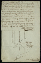
A Plan of Ronald McDonalds Land of Grand Tracadie For The Surveyors Generals Office
Description: Plan of part of Lot 35 (No. 5). The map shows 175 acres of land belonging to Ronald McDonald at Grand Tracadie in the northern part of Lot 35. The map shows the names of the residents on either side… more
Province: Prince Edward Island
Type: cadastral maps
Date Created: 1824-08-03
Plan Shewing the situation of the respective Fishing Establishments, Fronting Harris or Rustico Bay…
Description: Plan of part of Lot 24. Shows situation of the fishing establishments fronting Harris or Rustico Bay. From actual survey. The map shows the Harbours Mouth and Robinsons Island.
Province: Prince Edward Island
Type: cadastral maps
Date Created: 1869-09-02
Charlottetown Prince Edward Island: Population: 12,500. July 1903
Description: This item, the first of 20 pages of fire insurance maps of Charlottetown, serves as the key plan for the other Charlottetown pages. It was created in 1903, revised to 1910 and revised again to 1917.… more
Publisher: Chas. E. Goad, Civil Engineer
Province: Prince Edward Island
Type: fire insurance maps
Date Created: 1903-07
Date Modified: 1910-08, 1917-07
Date Issued (Source): 1888
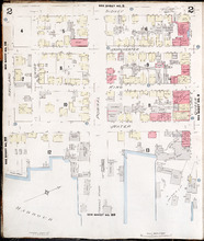
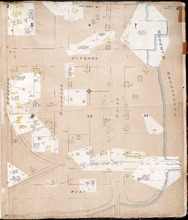
Charlottetown, Prince Edward Island: July 1917. Reprinted
Description: This is Page 2 of 20 pages of fire insurance maps of Charlottetown. It shows the area from Sidney Street to the waterfront, between Haviland and Queen streets. The map shows numbered city blocks and… more
Publisher: Chas. E. Goad, Civil Engineer
Province: Prince Edward Island
Type: fire insurance maps
Date Created: 1917-07
Date Issued (Source): 1888
Charlottetown, Prince Edward Island: July 1917. Reprinted
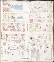
Description: This is Page 3 of 20 pages of fire insurance maps of Charlottetown. It shows the area from Sidney Street to the waterfront, between Queen and Prince streets. The map shows numbered city blocks and… more
Publisher: Chas. E. Goad, Civil Engineer
Province: Prince Edward Island
Type: fire insurance maps
Date Created: 1917-07
Date Issued (Source): 1888
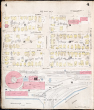
Charlottetown, P.E.I.: July 1903
Description: This is Page 4 of 20 pages of fire insurance maps of Charlottetown. It was created in 1903 and revised to either 1910 or 1917. The map shows the area from Sidney Street to the waterfront, between… more
Publisher: Chas. E. Goad, Civil Engineer
Province: Prince Edward Island
Type: fire insurance maps
Date Created: 1903-07
Date Modified: 1910-08, 1917-07 (year and month uncertain)
Date Issued (Source): 1888

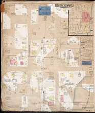
Plan of Georgetown, Georgetown Common, and Georgetown Royalty
Description: Plan of Georgetown, Georgetown Common, and Georgetown Royalty. Shows lot numbers. Gives names of a few residents in the Royalty. Also gives nautical soundings for Albion Bay and Brudenell River.
Province: Prince Edward Island
Type: cadastral maps
Date Created: 1828