Displaying 109 - 135 of 239

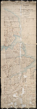
Plan of New Line Road from South Wiltshire Road Lot 31 to Emyvale Road Lot 65
Description: Plan of new line of road from South Wiltshire Road, Lot 31, to Emyvale Road, Lot 65. The map shows lots, roads, and residents.
Province: Prince Edward Island
Type: cadastral maps
Date Created: 1892-12-29

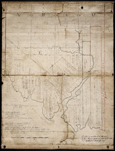
Plan of Lot 50
Description: Plan of Lot 50. Shows names of residents, acreage, and some land conveyance references, roads, and bodies of water such as rivers (Orwell), and bays (Pownal).
Province: Prince Edward Island
Type: cadastral maps

Plan of Township No. 32: compiled from the proprietors plans and Meacham's Atlas and from the…
Description: The map shows Lot 32 divided into parcels of land with names of residents, acreage amounts and land conveyance references. Areas drawn in black indicate government land; areas in red indicate… more
Province: Prince Edward Island
Type: cadastral maps
Date Created: 1919-01

Plan of Township No. 57: Compiled from the proprietors plans and Meacham's Atlas, and from the…
Description: The map shows Lot 57 divided into parcels of land with names of residents, acreage amounts and land conveyance references. Areas drawn in black indicate land conveyed to the government and re-… more
Province: Prince Edward Island
Type: cadastral maps
Date Created: 1917
Plan of the Western Moiety of Township No.20: Grenville Parish, Queens County, P. E. Island
Description: Plan of the Western Moiety of Township No.20, showing residents.
Province: Prince Edward Island
Type: cadastral maps
Date Created: 1850
Plan of Lot & Township No. 22 in Prince Edward Island: Part of the Estate of the Right…
Description: Plan of Lot 22 (No.59). Sullivan Estate.
Province: Prince Edward Island
Type: cadastral maps

Lot 22
Description: Plan of Lot 22 showing residents.
Province: Prince Edward Island
Type: cadastral maps
Plan of Township No. 24: Copied from plan furnished by Proprietors with numerous corrections from…
Description: Working plan of Lot 24 (No.67). Winsloe Estate. Surveyed by H.J Cundall and others; copied by Thos. MacKinlay.
Province: Prince Edward Island
Type: cadastral maps
Date Created: 1886-02

Plan of Township No. 29: embracing the Fane and Melville Estates – 1883
Description: Plan of Lot 29 (No.80). Fane and Melville Estates.
Province: Prince Edward Island
Type: cadastral maps
Date Created: 1883

Lot 30: Refugee Share drawn for in Council this 18th day of September 1784, John Spencer
Description: Plan of Lot 30 (No.1) showing Refugee Shares drawn for in Council, 18 September, 1784.
Province: Prince Edward Island
Type: cadastral maps
Date Created: 1784

Plan of Township No. 30 belonging to R. Bruce Stewart, Drawn by Robt. Stewart 1861 from surveys…
Description: The map shows Lot 30 divided into numbered sub-lots. There are nine different series of sub-lot numbers which are colour-coded according to the map legend. The different colours represent Line Road,… more
Province: Prince Edward Island
Type: cadastral maps
Date Created: 1861

Plan of Township 30
Description: Plan of Lot 30 (No.82). Stewart Estate. Shows names of residents.
Province: Prince Edward Island
Type: cadastral maps
Lot 31: Southern portion
Description: Plan of the southern part of Lot 31, showing residents. In use 1819. From H.J. Cundall.
Province: Prince Edward Island
Type: cadastral maps

Lot 32
Description: Plan of Lot 32 showing some residents.
Province: Prince Edward Island
Type: cadastral maps

Plan of Township No. 33 in Prince Edward Island: Part of the Estate of John Hodges Winsloe Esq.…
Description: Plan of Lot 33. Winsloe Estate.
Province: Prince Edward Island
Type: cadastral maps
Date Created: 1834-09-20

Lot 34: Southern portion
Description: Part of Lot 34 (No.7). North side of Hillsborough River.
Province: Prince Edward Island
Type: cadastral maps

Plan of the Western Portion of Township No. 65: containing 5250 acres and belonging to Mrs. Lydia…
Description: Plan of the western portion of Lot 65 (No.173). Estate of Mrs Lydia Wright. Roads, leased land[?] and freehold land on the Estate of Mrs. Lydia Wright. Tenant names appear on the sub-lots, which are… more
Province: Prince Edward Island
Type: cadastral maps
Date Created: 1841

Plan of Lot or Township No. 34
Description: Plan of Lot 34 (No. 90). Montgomery Estate. Working plan. The map shows Lot 34 divided into parcels of land with the names of residents and their acreage amounts handwritten in black ink. Land… more
Province: Prince Edward Island
Type: cadastral maps
Plan Shewing the Northern Boundary Line of the Victoria Park Roadway as Surveyed by Thomas W. May L…
Description: Plan showing the northern boundary line of the Victoria Park Roadway. This is the plan referred to in "The Victoria Park Roadway Act, 1896". Shown is the Charlottetown Harbour, Governor… more
Province: Prince Edward Island
Type: cadastral maps
Date Created: 1896

Plan Shewing the Eligible Situation of Acre Lots on the Estate of the Honble. J. C. Pope. in the…
Description: Plan showing the eligible situation of acre lots on the estate of Hon. J.C. Pope in the Royalty of the city of Charlottetown. Royalty Lots No.85, No.95 and No.97. (No.386)
Province: Prince Edward Island
Type: cadastral maps
Date Created: 1878
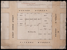
Holland Grove
Description: Plan of the block of land between Euston Street and Fitzroy Street and Prince Street and Great George Street known as Holland Grove. Town Lots 18-22 and 63-67 in the fifth hundred.
Province: Prince Edward Island
Type: cadastral maps
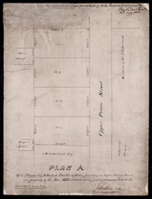
Plan A. Of 4 Pleasantly Situated Building Lots, fronting on Upper Prince Street, The property of…
Description: Plan "A" of four pleasantly situated lots fronting on Upper Prince Street, the property of the Hon. T.H. Haviland, Common Lot No.24. (No.60) more
Province: Prince Edward Island
Type: cadastral maps
Date Created: 1886

Plan of St. Avard's divided into Building Lots part of the Estate of the Honble. James C. Pope…
Description: Plan of St. Avards divided into building lots, part of the estate of the Hon. James C. Pope in the Royalty of Charlottetown. Royalty Lot No.13. Also shown are St. Peters Road, and Mt. Stewart Road.
Province: Prince Edward Island
Type: cadastral maps
Date Created: 1878

Plan showing the situation of part of the Estate of the late Owen Connolly Esq. in Charlottetown…
Description: Plan showing the situation of part of the Estate of the late Owen Connolly in Charlottetown Common and Royalty. Created by John Ball, surveyor, and copied by Thomas W. May. The map shows Malpeque… more
Province: Prince Edward Island
Type: cadastral maps
Date Created: 1921-01

Plan of 1390 Acres of Land part of Township No. 65: The property of the Hon,, Smauel Cunard…
Description: Plan of part of Lot 65 (No.172). 1390 acres of land, part of the property of the Hon. Samuel Cunard. One of the plans referred to in the Deed from Sir Edward, William, and Laura Cunard to the… more
Province: Prince Edward Island
Type: cadastral maps
Date Created: 1866-07-13
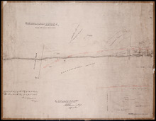
Plan of an approximate correction of the Junction of the Maitland road with the Murray Harbour Road…
Description: Plan of an approximate correction of the Junction of the Maitland Road with the Murray Harbour Road as sketched in sundry plans by the late Roderick Campbell... and as measured on the ground on the… more
Province: Prince Edward Island
Type: cadastral maps
Date Created: 1921-09-09
Plan of Lot or Township No. 58: Copied from Surveys of Rodk. Campbell. L. S. by Owen Curtis. L. S.
Description: Plan of Lot 58 (No.155). Shows names of residents, acreage, and land conveyance references. Surveyed by Rod'k Campbell and copied by Owen Curtis. The map shows roads, and bodies of water such as… more
Province: Prince Edward Island
Type: cadastral maps