Displaying 217 - 243 of 992
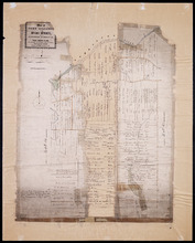
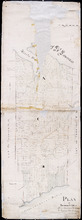
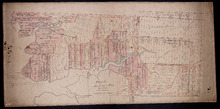
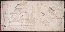
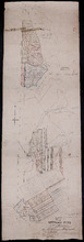
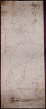
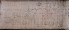
Plan of Fort Augustus and Monaghan Settlement in Township Number 36, in Prince Edward Island, the…
Description: Plan of Fort Augustus and Monaghan Settlement in Lot 36, the property of the Rev. John McDonald. Shows names of residents and acreage, bodies of water such as rivers (Hillsborough), ponds, roads, and… more
Province: Prince Edward Island
Type: cadastral maps
Date Created: 1840
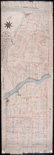
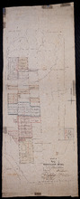
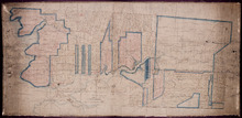
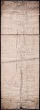
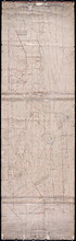
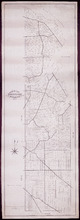
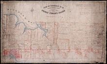
Plan of Township No. 36 Comprising the Estates of Helen Jane MacDonald, Rev. J. A. S. MacDonald and…
Description: Plan of Lot 36 (No.100) comprising the Estates of Helen Jane MacDonald, Rev. J.A.S. MacDonald, and W.C. MacDonald. Shows names of residents, acreage, and land conveyance references, bodies of water… more
Province: Prince Edward Island
Type: cadastral maps
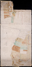
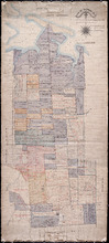
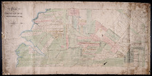
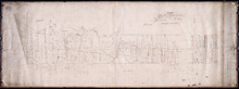
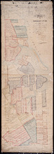
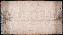
A Plan of part of Township No. 36
Description: A plan of the estate of the late Hon. Donald McDonald comprising part of Lots 35 and 36 divided and apportioned into six shares by Messrs. Aldous, Cundall, and Haythorne under power of an agreement… more
Province: Prince Edward Island
Type: cadastral maps
Date Created: 1865-02-03
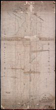
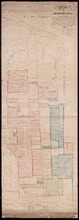
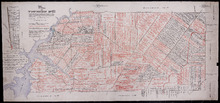
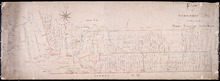
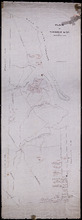
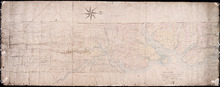
A Plan of Township No. 34, The Property of Sir Graham Montgomery & Brothers Situate in Queens…
Description: Plan of Lot 34 (No.89). The property of Sir Graham Montgomery & Brothers. Shows names of residents and acreage, bodies of water such as rivers, and bays, roads, and a nautical compass.
Province: Prince Edward Island
Type: cadastral maps
Date Created: 1850-03-19
Plan of Township No,, 34 in Queens County in P. E. Island. The Property of Messrs,, Montgomeries,…
Description: Plan of Lot 34. Property of Messrs. Montgomery. Shows names of residents and acreage. Plan handed in to Registry Office by Aemeas McDonald. The map also shows bodies of water, bays, rivers, ponds,… more
Province: Prince Edward Island
Type: cadastral maps
Date Created: 1853-08
Plan "B" part of Township No. 33. as divided amongst the Children of the late Alfred…
Description: Plan of part of Lot 33 as divided amongst the children of the late Alfred Winsloe. Plan B. (No.87). The map also shows Rustico and Covhead Bays, along with Brackley Point, Union, Malpeque, and… more
Province: Prince Edward Island
Type: cadastral maps
Date Created: 1872-06-11
Plan of Township No. 33 In Prince Edward Island. Part of the Estate of the late John Hodges Winslow…
Description: Plan of Lot 33 (No.88). Part of the estate of the late John Hodges Winslow. Copied from the Original Plan by Thos. MacKinlay, April 23, 1847. Shows names of residents, acreage, and land conveyance… more
Province: Prince Edward Island
Type: cadastral maps
Date Created: 1847-04-23
Plan of Township No. 33. in Prince Edward Island.: referred to in the Deed of Partition [...]
Description: Plan of Lot 33 referred to in the Deed of Partition between Alfred Winsloe, Henry Winsloe, Sydney T. Evans and wife, and Anne Winsloe, March 13, 1863. Shows names of residents and acreage, bodies of… more
Province: Prince Edward Island
Type: cadastral maps
Date Created: 1863-03-13
Plan of Lot 32 (No.86).: Cunard Estate.
Description: Plan of Lot 32 (No.86). Cunard Estate. Shows names of residents, acreage, and some land conveyance references, bodies of water such as creeks and rivers, and roads. Copied by Owen Curtis.
Province: Prince Edward Island
Type: cadastral maps
Date Created: 1876-07

Plan of Township No. 32: compiled from the proprietors plans and Meacham's Atlas and from the…
Description: The map shows Lot 32 divided into parcels of land with names of residents, acreage amounts and land conveyance references. Areas drawn in black indicate government land; areas in red indicate… more
Province: Prince Edward Island
Type: cadastral maps
Date Created: 1919-01
Plan of Township No. 32 situate in the Parish of Charlotte, Queens County, P. E. Island: Scale 20…
Description: Plan of Lot 32 (No.85). One of the plans referred to in the Deed from Sir Edward, William, and Laura Cunard to the Commissioner of Public Lands, July 13, 1866. Shows names of residents, acreage, and… more
Province: Prince Edward Island
Type: cadastral maps
Date Created: 1849
Plan of Township No. 31 in Prince Edward Island
Description: Plan of Lot 31 from H.J. Cundall, one of the Trustees of the Wm. Douse Estate (Death of Wm. Douse in 1864). Shows names of residents, acreages, and some land conveyance references, bodies of water… more
Province: Prince Edward Island
Type: cadastral maps
Plan of Township No. 31: compiled from the proprietors plans and Meacham's Atlas and from the…
Description: Plan of Lot 31 compiled from the Proprietors' plans and Meacham's Atlas and from the descriptions in leases and registered deeds, with additions and corrections from various surveys made… more
Province: Prince Edward Island
Type: cadastral maps
Date Created: 1917-12
Titles to Lot 31
Description: Plan of Lot 31 (No.84). Douse Estate. Shows names of some residents, some acreage, some land conveyance references, roads, and a nautical compass.
Province: Prince Edward Island
Type: cadastral maps
Plan of the East Moriety of Lot or Township No 29: part of the Estate of Lord Vicount Melville…
Description: Plan of the east moiety of Lot 29 (No.79). Part of the estate of Lord Viscount Melville. Shows names of residents, acreage, and a few land conveyance references, bodies of water such as the… more
Province: Prince Edward Island
Type: cadastral maps
Plan of Township No. 26: Embracing the Thomson Holland and Stephens Estates
Description: Plan of Lot 26 embracing the Thomson, Holland, and Stephens Estates. Shows names of residents, acreage, and land conveyance references, bodies of water such as river, cove, and pond, roads, and a… more
Province: Prince Edward Island
Type: cadastral maps
Plan of the North Moriety of a Township No. 26 the Property if the Messrs Thompson of Belfast…
Description: Plan of the North Moiety of Lot 26, the property of the Messrs. Thompson of Belfast Ireland. Shows names of residents, acreage, and a few land conveyance references, bodies of water such as Bedeque… more
Province: Prince Edward Island
Type: cadastral maps
Date Created: 1875-11-05
Plan "A" Part of Township No. 24: as divided amongst the children of the late Alfred…
Description: Plan "A" part of Lot 24 as divided amongst the children of the late Alfred Winsloe (No.64). Shows names of residents and acreage, bodies of water such as rivers, creeks, roads, and a… more
Province: Prince Edward Island
Type: cadastral maps
Date Created: 1872-06-11
Plan of Lot 24 (No.66): Part of the estate of John Hodges Winsloe
Description: Plan of Lot 24 (No.66). Part of the estate of John Hodges Winsloe. Shows names of residents, acreage, and a few land conveyance references, bodies of water such as Gulf of St. Laurence, rivers, roads… more
Province: Prince Edward Island
Type: cadastral maps
Date Created: 1847
This is the Plan of Township No. 24 in Prince Edward Island
Description: Plan of Lot 24 showing the division of the Winsloe Estate. Shows names of residents and acreage, bodies of water such as gulfs, bays, creeks, rivers, sand hills, Rustico or Peter's Island and… more
Province: Prince Edward Island
Type: cadastral maps
Date Created: 1863-03-13
Plan of Township No. 24 in Prince Edward Island
Description: Plan of Lot 24. Smith Estate. Mainly outline but shows a few residents and acreage, bodies of water such as rivers, gulfs, bays and creeks, roads, sand hills, and Rustico or Peter's Island. more
Province: Prince Edward Island
Type: cadastral maps
Plan of the property of Mrs W.L. Smith : Situate on Township No. 24 in Prince Edward Island, Mrs L…
Description: Plan of the property of Mrs W.S. Smith. Situated on Lot 24. The maps shows bodies of water such as rivers and creeks, Rustico Island, roads, and a nautical compass.
Province: Prince Edward Island
Type: cadastral maps
Plan of Township No. 24 Situate in Grenville Parish. Queen's County. P.E.Island.: Complied…
Description: Plan of Lot 21 situate in Grenville Parish (No.54). Compiled from actual surveys. Cunard Estate. Shows names of residents and acreage, bodies of water such as gulfs, rivers, and creeks, roads, and a… more
Province: Prince Edward Island
Type: cadastral maps
Date Created: 1844
Plan of Lot Twenty One : Queens Co P.E.I.
Description: Plan of Lot 21 drawn from old maps, plans, and records. Shows names of residents, acreage, and land conveyance references, bodies of water such as bays, ponds, gulfs, and rivers, roads, and a… more
Province: Prince Edward Island
Type: cadastral maps
Date Created: 1952
Plan of part of Lot 19 (No.48)
Description: Plan of part of Lot 19 (No.48). Hodgson and Yeo Estates. Shows names of some residents, bodies of water such as bays, roads, division lines.
Province: Prince Edward Island
Type: cadastral maps
Plan of Township No. 16 in Prince Edward Island: The Property Of Miss Sullivan
Description: Plan of Lot 16 (No.44). The property of Miss Sullivan. Shows names of residents, bodies of water, roads, and a compass. Color code shows freehold lands purchased from the Proprietor and other… more
Province: Prince Edward Island
Type: cadastral maps
Plan of Township No. 19: Situate in Prince County The Property of A.T.Todd ESQ. Toronto, Prince…
Description: Plan of Lot 19, the property of A.T. Todd, Toronto. Plan referred to in the Indenture dated 11 November, 1871 between A.T. Todd and E.J. Hodgson. Plan also referred to in a conveyance from E.J.… more
Province: Prince Edward Island
Type: cadastral maps