Displaying 163 - 189 of 992

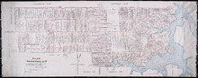
Plan of Township No. 30 belonging to R. Bruce Stewart, Drawn by Robt. Stewart 1861 from surveys…
Description: The map shows Lot 30 divided into numbered sub-lots. There are nine different series of sub-lot numbers which are colour-coded according to the map legend. The different colours represent Line Road,… more
Province: Prince Edward Island
Type: cadastral maps
Date Created: 1861
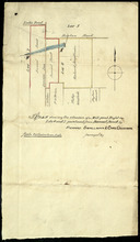
Plan shewing the situation of a Mill-pond Right on Lots 6 and 7, purchased from Samuel Sweet, by…
Description: Plan of part of Lots 6 and 7 showing the situation of a Mill-pond right purchased from Samuel Sweet by Richard Smallman and Chas. Crossman. The mill pond is located in the area where Lots 5, 6 and 7… more
Province: Prince Edward Island
Type: cadastral maps
Part of Lot No. 26
Description: Plan of part of Lot 26 (No.3). Plan traced[?] by J. Plaw from a survey by Mr. Major[?]. The maps shows part of Lot 26 (the Centreville area) divided into parcels of land with the names of residents… more
Province: Prince Edward Island
Type: cadastral maps
Date Created: 1810-05-23

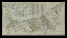
Plan of Township No. 64: compiled from the proprietors' plans, descriptions in leases and…
Description: The map shows Lot 64 divided into parcels of land with names of residents, their acreage amounts and land conveyence references. Land information written in black indicates government land;… more
Province: Prince Edward Island
Type: cadastral maps
Date Created: 1920
Plan of Township No. 20.: Compiled from Surveys by Jas. Stewart, L. W. Gall, George Wright, Joseph…
Description: Plan of Lot 20. The map shows Lot 20 divided into parcels of land with names of some residents and some acreage amounts. The map notes freehold land. Shows roads in a light brown colour, marsh areas… more
Province: Prince Edward Island
Type: cadastral maps

Plan of Township No. 5: compiled from plans, leases, deeds, and other documents on file in the Land…
Description: Plan of Lot 5 compiled from plans, leases, deeds, and other documents on file in the Land Office. The map shows Lot 5 divided into parcels of land with names of residents, their acreage amounts and… more
Province: Prince Edward Island
Type: cadastral maps
Date Created: 1911-09

Plan of Town Lots at Cascumpec Point. Township No. 5.: Compiled and corrected from Surveys by John…
Description: Plan of Town Lots at Cascumpec Point, Lot 5. The map shows Cascumpec Point divided into parcels of land (most of them numbered) with names of residents. Shows land belonging to J. C. Pope outlined in… more
Province: Prince Edward Island
Type: cadastral maps
Date Created: 1877-08-01

Plan of Cascumpec Point Copied from a Plan in the Public Lands Departt. furnished by John Ball. L.…
Description: Plan of Cascumpec Point, Lot 5. The map shows numbered parcels of land on Cascumpec Point with names of residents and some land conveyance references. The legend indicates that parcels are outlined… more
Province: Prince Edward Island
Type: cadastral maps
Date Created: 1885-06
Plan of Township No. 6: Compiled from plans, leases, deeds, and other documents on file in the Land…
Description: The map shows Lot 6 divided into parcels of land with names of residents, their acreage amounts and land conveyance references handwritten in black and red ink. Shows the P.E.I. Railway in red, roads… more
Province: PE
Type: cadastral maps
Date Created: 1912-01
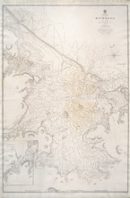
Hillsborough Bay
Description: Paper map in frame. Nautical chart originally published in 1842 and corrected and reissued many times. Large corrections in 1860, 1868, 1869, 1881. Relief is described pictorially, with hachures,… more
Publisher: Office of the Admiralty
Province: Prince Edward Island
Type: nautical charts
Date Issued: 1929
Date Created: 1842
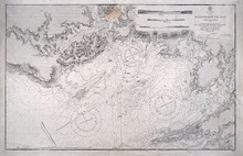
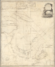
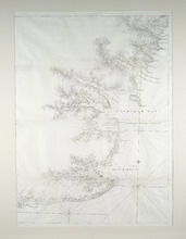
Richmond Bay: 1845
Description: Paper map in frame. Nautical chart originally published in 1845. Relief is described pictorially, with hachures, stippling and soundings. Bays, capes, heads, harbours, islands, lakes, ports, points,… more
Publisher: Hydrographic Office of the Admiralty
Province: Prince Edward Island
Type: nautical charts
Date Issued: 1850
Date Created: 1845
Plan of Île Saint-Jean: The Island of Saint John
Description: Plan of Ile Saint-Jean / the Island of Saint John. The map shows Prince Edward Island and a portion of the mainland. It identifies settlements, bays, harbours, rivers and islands. Sandy areas are… more
Province: Prince Edward Island
Type: topographic maps
Date Created: 1760
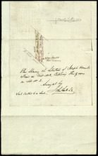
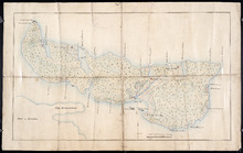
Plan Showing the Situation of Joseph Hammil's Farm on Lot No. 2. Containing Thirty acres on…
Description: Plan of part of Lot 2 showing Joseph Hammill's Farm containing 30 acres. The map shows Joseph Hammill's 30-acre parcel shaded in a greenish colour. It also shows the adjacent parcel of John… more
Province: PE
Type: cadastral maps
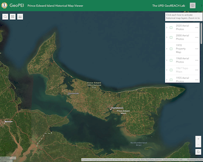
GeoPEI: Prince Edward Island Historical Map Viewer
Description: GeoPEI is a web portal developed by Dr. Josh MacFadyen and students in the GeoREACH Lab. Its purpose is to share maps, atlases, aerial photos, and geospatial data in an online map (aka. a webmap)… more
Publisher: UPEI GeoREACH Lab
Province: Prince Edward Island
Type: aerial photographs, cadastral maps
Date Created: 2024

IslandImagined - Digital Map Collection
Description: The Island Imagined is an online collection of historic maps of Prince Edward Island. The collection features maps, atlases, books, images, and documents from the Prince Edward Island Public Archives… more
Province: Prince Edward Island
Type: maps
A New Chart of the Gulf of St. Lawrence Compiled from the Original Drawings of Actual Surveys
Description: The most accurate chart of the Gulf of St. Lawrence in 1790, especially its depiction of Cape Breton Island. "The Most Detailed Chart of the St. Lawrence River to Date Fine example of Thomas… more
Publisher: William Faden
Province: Prince Edward Island, Nova Scotia, New Brunswick, Quebec
Type: nautical charts
Date Created: 1790
Prince Edward Island
Publisher: Chas. E. Goad, Civil Engineer
Type: fire insurance maps
Date Issued: 1888
Date Modified: 1910-08, 1917-07
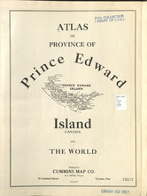
Atlas of Province of Prince Edward Island, Canada and the World
Description: Cummins devotes most of its opening pages to a detailing of the Island’s contribution to the First World War or “European War”. This event had forever changed many communities on the Island.
More… more
Publisher: Cummins Map Co.
Type: historical atlases
Date Issued: 1927

Illustrated historical atlas of the province of Prince Edward Island: From surveys made under the…
Description: Published in 1880 by the J. H. Meacham Company, the Illustrated Historical Atlas of the Province of Prince Edward Island contains maps of each Lot on the Island, maps of Charlottetown and various… more
Publisher: J. H. Meacham & company
Type: historical atlases, pictorial maps
Date Issued: 1880
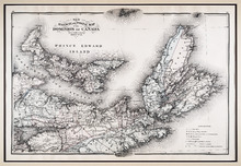
New Railway and Postal Map of the Dominion of Canada, Sheet No. 2
Description: Framed map shows the post offices, money order offices, P.O. saving offices, telegraph sections, ports of entry, railways and the distance between towns over post roads of the time. Prince Edward… more
Province: Prince Edward Island
Type: geological maps
Date Created: 1880
A Map of the Island of St. John in the Gulf of St. Laurence: Divided into Counties and Parishes and…
Description: The map shows the province of Prince Edward Island, but known to this map as St. John, and its counties. Shown are bodies of water, lots, cities, towns. roads, buildings, and Islands.
Type: topographic maps
Date Created: 1775-04-06
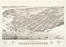
Panoramic view of Charlottetown, Prince Edward Island: 1878
Description: Panoramic, bird's eye view of Charlottetown from the harbour. Ships of various kinds, including sail and steam-powered, pictured in the foreground. View shows a busy, industrial waterfront with… more
Publisher: Prince Edward Island Museum and Hertiage Foundation
Province: Prince Edward Island
Type: bird's-eye views
Date Issued: 1983
Date Created: 1878
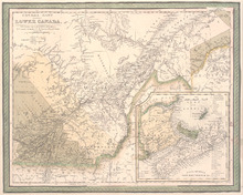
Canada East formerly Lower Canada
Description: Includes Quebec and Maritimes. Colour by region - primarily beige, yellow, green (compared to other versions of this map, the colours are muted). Inset map includes numbered counties for New… more
Publisher: Mitchell, S. Augustus, S. Augustus Mitchell
Province: Prince Edward Island
Date Created: 1846
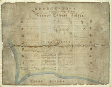
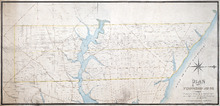
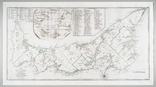
Plan of George-Town: Capital of Kings County, Prince Edward Island
Description: A hand-drawn map of Georgetown, PEI that includes the layout of the town including Kent Square, the ranges, house lots, water lots, and buildings. Three Rivers borders the town.
Province: Prince Edward Island
Date Created: 1835