Displaying 190 - 216 of 992

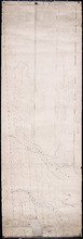
Map of Prince Edward Island in the Gulf of St. Lawrence: for McGregor's British America
Publisher: Ballantyne and Company
Province: Prince Edward Island
Type: cadastral maps, topographic maps
Date Created: 1832
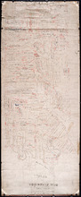
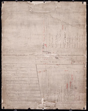
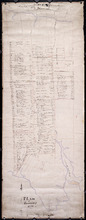
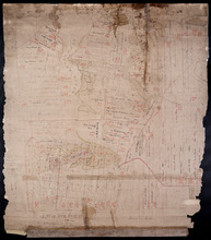
Plan of Township No. 56: Copied from the Survey of J. C. Underhay By Owen Curtis. L. S.
Description: Plan of Lot 56 (No.150). Shows names of residents, acreage, and some land conveyance references. Surveyed by J.C. Underhay and copied by Owen Curtis. The map also shows bodies of water such as… more
Province: Prince Edward Island
Type: cadastral maps
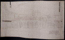
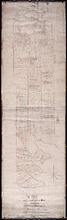
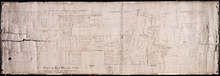
Plan of Lot 50
Description: Plan of Lot 50. Shows names of residents, acreage, and some land conveyance references, roads, and bodies of water such as rivers (Orwell), and bays (Pownal).
Province: Prince Edward Island
Type: cadastral maps

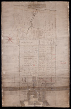
Plan of Township No. 55: Compiled from the plans on file in the Land and Registry Offices, from the…
Description: Plan of Lot 55 compiled from the plans on file in the Land and Registry Offices, from the descriptions in the registered Grants and from Meacham's Atlas. Shows names of residents, acreage, and… more
Province: Prince Edward Island
Type: cadastral maps
Date Created: 1919

Township No. Fiftyfour. St. Georges Parish. Kings County. Prince Edward Island.: Chiefly from…
Description: Plan of Lot 54 (No.145). Shows names of residents, acreage, and some land conveyance references. Copied by H.J. Cundall. Certified plan. The map also shows bodies of water such as rivers (Cardigan),… more
Province: Prince Edward Island
Type: cadastral maps
Plan of the Estate of the Hon. Spencer Cecil Brabazon Ponsonby Fane Situate on Lot or Township No.…
Description: Plan of Lot 53 showing the estate of the Hon. Spencer Cecil Brabazon Ponsonby Fane. Copied by R.T. Weeks. Shows names and acreage of some residents, roads, and rivers such as Morell.
Province: Prince Edward Island
Type: cadastral maps
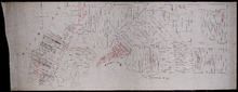
Plan of Lot or Township No. 53, shewing the positions of the respective boundaries thereof. Those…
Description: Plan of Lot 53 showing the position of the boundaries of the Melville, Selkirk and Westmoreland Estates (No.5). Shows names and acreage of a few residents, bodies of water such as rivers (Brudnell),… more
Province: Prince Edward Island
Type: cadastral maps
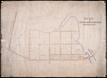
Royalty of Georgetown
Description: Plan of Lot 53 showing the estate of Lady Westmoreland. Shows names of residents and acreage, roads, and bodies of water such as rivers (Montague). Also shows the division line between the estate of… more
Province: Prince Edward Island
Type: cadastral maps
Plan Township No. 53. comprising parts of the Melville, Selkirk, and Fane Estates. Compiled and…
Description: Plan of Lot 53 comprising parts of the Melville, Selkirk and Fane Estates (No.144). Shows names, acreage, and land conveyance references for some residents, bodies of water such as rivers, and… more
Province: Prince Edward Island
Type: cadastral maps
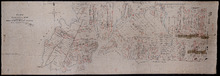
Plan of Pierce Gaul's Estate Montague-Bridge
Description: Plan of Pierce Gaul's Estate, Montague Bridge, Lot No.52. The map shows the Montague River, streets, and buildings. more
Province: Prince Edward Island
Type: cadastral maps
Date Created: 1877-05

Plan of Lot or Township No. 51 in Kings County P. E. Island
Description: Plan of Lot 51 (No.139) Colour code shows freehold and unsold portions. Sir Graham Montgomery Estate. Shows names, acreage, and land conveyance references of some residents, and roads.
Province: Prince Edward Island
Type: cadastral maps
Plan of Township No. 50, the Property of Maria Susanna Matilda Fanning
Description: Plan of Lot 50, the property of Maria Susanna Matilda Fanning. Shows names of residents, acreage, and land conveyance references, bodies of water such as rivers (Vernon), bays (Pownal), and roads.… more
Province: Prince Edward Island
Type: cadastral maps

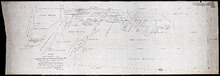
Plan of certain tracts of land at or near Orwell according to registered deeds, and two surveys…
Description: Plan of part of Lot 50. Clark's Corner, Orwell. Shows certain tracts of land at or near Orwell according to registered deeds and two surveys. Rough copy included. more
Province: Prince Edward Island
Type: cadastral maps

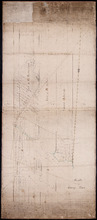
Plan of Part of Township No. 49. Bedford Parish. Queens County. P. E. Island.
Description: Plan of part of Lot 49 (No.135). One of the plans referred to in the deed from Sir Edward, William, and Laura Cunard to the Commissioner of Public Lands, July 13, 1866. The portion of land intended… more
Province: Prince Edward Island
Type: cadastral maps
Date Created: 1850
Plan of part of Lot 50
Description: Plan of part of Lot 50 (No.13). Area east of the Murray Harbour Road, north of the Dundee Road, and south of Georgetown Road. Shows names of residents.
Province: Prince Edward Island
Type: cadastral maps

Plan of Township Number 49. Shewing "Cunard" portion borderd. yellow. "Loan Act…
Description: Plan of Lot 49 showing Cunard portion bordered yellow, Loan Act Land bordered green, and remainder of Township (No.134). Copied from Meacham's Atlas by Owen Curtis. Shows names of residents,… more
Province: Prince Edward Island
Type: cadastral maps
Date Created: 1883-08
Plan of Lot 48 east of Fullerton's Creek
Description: Plan of that part of Lot 48 east of Fullerton's Creek. Shows names of residents and acreage. (No.13 in Plan Book) (Also, No.924) more
Province: Prince Edward Island
Type: cadastral maps
Date Created: 1874-01
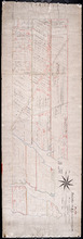
Lot 45 (No.122)
Description: Plan of the northeastern part of Lot 45 (No.122). Shows names of residents and acreage and a nautical compass.
Province: Prince Edward Island
Type: cadastral maps
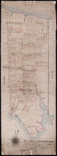
Plan of Township No. 44. Corrected from Surveys by Owen Curtis, J. C. Underhay and others. By Thos…
Description: Plan of Lot 44 (No.118) corrected by Thomas MacKinlay from surveys by Owen Curtis, J.C. Underhay and others. Cunard Estate. Shows some residents' names, acreage, and land conveyance references,… more
Province: Prince Edward Island
Type: cadastral maps
Date Created: 1887-09
Plan of Township No. 44.
Description: Plan of Lot 44 (No.120). Cunard Estate. Shows names and acreage of some residents, bodies of water such as rivers and gulfs, roads, and a mills (MacGowans).
Province: Prince Edward Island
Type: cadastral maps
A Plan of Lot or Township No. 43, Comprising the Haviland, Townsend, and Worrell Estates. Compiled…
Description: Plan of Lot 43 (No.116) comprising the Haviland, Townshend, and Worrell Estates. Completed from the surveys of J. Ball and J.C. Underhay by Owen Curtis. Shows names of residents, acreage, and land… more
Province: Prince Edward Island
Type: cadastral maps
Date Created: 1876-08
Plan of Lot 42 (No.112)
Description: Plan of Lot 42 (No.112). Shows names and acreage of some residents, bodies of water, and roads.
Province: Prince Edward Island
Type: cadastral maps
Pla of Lot or Township No. 42
Description: Plan of Lot 42 (No.113). Worrell Estate. Shows names of residents, acreage, and land conveyance references.
Province: Prince Edward Island
Type: cadastral maps
A Map and Survey of Part of Township Number Thirtyfive south side of the Hillsborough river, by…
Description: A map and survey of part of Lot 35, south side of the Hillsborough River. Shows names of residents, acreage, and land conveyance references, bodies of water such as rivers, and raods.
Province: Prince Edward Island
Type: cadastral maps
Date Created: 1887-03

Plan of Lot 39
Description: Plan of Lot 39. Shows names of residents and acreage, bodies of water such as rivers, and bays, and division lines.
Province: Prince Edward Island
Type: cadastral maps
Date Created: 1857-07-01
Plan of Lot or Township No. 38: Compiled from the Survey of Jos.h Ball by O. Curtis, Land Office…
Description: Plan of Lot 38 (No.102). Shows names of residents, acreage, and some land conveyance references, bodies of water such as bays, rivers, ponds, gulfs, and harbours, roads, and a nautical compass.
Province: Prince Edward Island
Type: cadastral maps
Date Created: 1876-08

Plan of Lot Thirty Seven: Queens Co., P.E.I.
Description: Map of Lot 37 and part of Lot 38. Map is from Meacham's 1880 PEI Historical Atlas. A few land conveyance references have been added in red ink. The map shows bodies of water such as rivers,… more
Province: Prince Edward Island
Type: cadastral maps
Date Created: 1880