Displaying 244 - 270 of 603
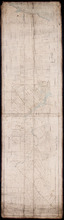
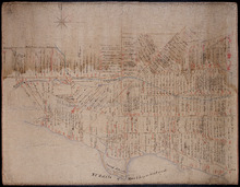
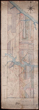
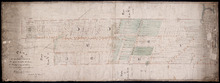
Plan of Lot 23
Description: Plan of Lot 23. Shows names of residents in central portion of Lot, i.e. around Clyde River.
Province: Prince Edward Island
Type: cadastral maps
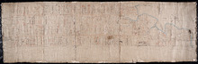
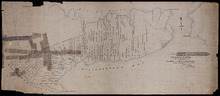
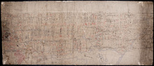
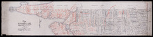
Tracing from Plan of North part of P. E. Island surveyed by Captn. Bayfield
Description: Tracing from plan of North part of Prince Edward Island surveyed by Captain Bayfield. Tracing by H.J. Cundall. Outline of coast, Lots 1-11. (No.94). The map shows bodies of water such as Gulf Shore,… more
Province: Prince Edward Island
Type: cadastral maps

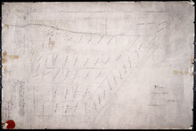
Plan of Building Lots in Common Lots Nos. 28 and 29 (Palmer Estate)
Description: Plan of building lots in Common Lots No.28 and No.29. The Palmer Estate. The map also shows streets such as Euston, Orlebar, lot numbers and acreage.
Province: Prince Edward Island
Type: cadastral maps
Date Created: 1913

Plan of Right of Way as on the Ground part of Town Lot No. 36 in the 4th Hund. Charlottetown.
Description: Plan of the Right of Way through Town Lot No.36 in the 4th Hundred in Charlottetown. (No.40). The map shows Kent Street and landowners.
Province: Prince Edward Island
Type: cadastral maps
Date Created: 1898-06
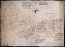
Plan of Ardgowan Estate in the Royalty of Charlotte Town
Description: Plan of Ardgowan Estate in the Royalty of Charlottetown as sold by auction, 26th June, 1879. Property of the Hon. J.C. Pope. (No.392). The map shows roads such as St. Peters, Confederation, lots,… more
Type: cadastral maps
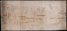
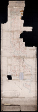
Plan of Lot 61 - Untitled
Description: Plan of Lot 61 (No.163). Sullivan Estate. Shows names of residents, acreage, and some land conveyance references bays and a nautical compass pointing North.
Province: Prince Edward Island
Type: cadastral maps
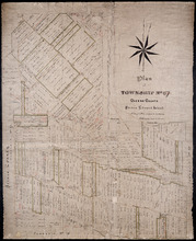
Plan of Township No. 67 Queens County Prince Edward Island: A Copy of a Plan compiled by Geo.…
Description: A copy of a plan of Lot 67 compiled by Geo. Wright, 1858, slightly altered to agree with Meacham's Atlas (No.179). Shows names of residents and acreage, lots, streets and roads, and post offices. more
Province: Prince Edward Island
Type: cadastral maps
Date Created: 1885-07

Plan of Township No. 67 in Prince Edward Island: The Property of Lady Wood
Description: Plan of Lot 67 (No.180). The property of Lady Wood. Shows names of residents, acreage, and some land conveyance references and a compass pointing North.
Province: Prince Edward Island
Type: cadastral maps
Date Created: 1858
Plan of 1390 Acres of Land part of Township No. 65: The Property of the Honble. Samuel Cunard.…
Description: Plan of Lot 65 (No.178). Shows names of residents, acreage, and land conveyance references. Color code indicates freehold land and the estates of the Wrights, Cunard and Cumberland. Shows bodies of… more
Province: Prince Edward Island
Type: cadastral maps
Plan of Part of Township No. 65: The Property of Col. B.H. and Mrs Cumberland
Description: Plan of part of Lot 65 (No.171). The property of Col. B.H. and Mrs Cumberland. Shows names of residents and acreage. Plan copied by R.T. Weeks. The map shows bodies of water such as Elliott River,… more
Province: Prince Edward Island
Type: cadastral maps
Plan of Township 64
Description: Plan of Lot 64 (No.169). Cunard Estate. Shows names of residents, acreage, and land conveyance references. The map shows bodies of water such as Gulf of Saint Lawrence, and Murray River, Murray… more
Province: Prince Edward Island
Type: cadastral maps
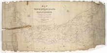
Map of Prince Edward Island, in the Gulf of St. Lawrence,: Compiling the latest Topographical…
Description: Map of Prince Edward Island by George Wright, Surveyor General, 1852. The Sea Coast, Rivers, Vc. being laid down from the Survey recently completed by Captain H. W. Bayfield R.N. The map shows mail… more
Province: Prince Edward Island
Type: cadastral maps
Date Created: 1852
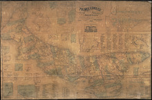
Topographical Map of Prince Edward Island in the Gulf of St. Lawrence
Description: Prince Edward Island divided into Counties and Parishes with the Lots as granted by Government, exhibiting all the New Settlements, Roads, Mills, etc. Published by H. Ashby, King Street, Cheapside,… more
Publisher: W. E. & H. H. Baker
Province: Prince Edward Island
Type: topographic maps, cadastral maps, pictorial maps
Date Created: 1863
Plan of Lot 63
Description: Plan of Lot 63. Shows names of residents, acreage, and land conveyance references. The map shows bodies of water such as Murray Bay/River, Gulf of St. Lawrence, and Murray Islands.
Province: Prince Edward Island
Type: cadastral maps

A Plan of the undisposed of Parts of Lot No. 62 in Queens County in Prince Edward Island by Rodk.…
Description: A plan of the undisposed part of Lot 62. Selkirk Estate (No.164). Shows names of residents and acreage.
Province: Prince Edward Island
Type: cadastral maps
Date Created: 1860
Plan of Lot 62 (No.165)
Description: Plan of Lot 62 (No.165). Selkirk Estate. Shows names of residents, acreage, and land conveyance references. The map shows a division line, bodies of water, Wood Islands, lots, landowners, acreage,… more
Province: Prince Edward Island
Type: cadastral maps
Plan of Township No. 55: From various Surveys made between the Years 1818 and 1845
Description: The map is a Plan of Township No. 55. The mqp shows bodies of water such as the Cardigan River, and Boughton River, lots, landowers, acreage, and Boughton Island.
Province: Prince Edward Island
Type: cadastral maps
Date Created: 1848-03-21
Plan Combining both Moieties of Township Number Twenty;: Copied from the Plans handed in by the…
Description: Plan of Lot 20 (No.52). Cunard and Cundall Estates. Copied from the plans handed in by the Proprietors (corrected where necessary by minor surveys, and chainage on leases) by Thos. MacKinlay. Shows… more
Province: Prince Edward Island
Type: cadastral maps
A Plan of Lot No. 61: By John Aldous from survey made in May & June 1842
Description: Plan of Lot 61 (No.162). Sullivan Estate. Landlord's plan. Shows names of residents and acreage. Signed by G.W. DeBlois. The map shows roads, bodies of water such as Sturgeon Bay and River,… more
Province: Prince Edward Island
Type: cadastral maps

A Plan of the undisposed of Parts of Lot No. 60 in Queens County in Prince Edward Island by Rodk.…
Description: A plan of the undisposed parts of Lot 60. Code indicates tracts of land sold and tracts of land without lease. Shows names of residents and acreage. Surveyed by Rod'k Campbell. A nautical… more
Province: Prince Edward Island
Type: cadastral maps
Date Created: 1860
Plan of Lot or Township No. 60 Copied from the Survey of Roderick Campbell by Owen Curtis. L. S.…
Description: Plan of Lot 60 (No.161). Copied from the survey of Roderick Campbell by Owen Curtis, 1877. Shows names of residents, acreage, and land conveyance references. The map shows bodies of water such as… more
Province: Prince Edward Island
Type: cadastral maps
Date Created: 1877
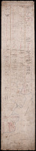
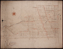
Plan of Lot 51 (No.140)
Description: Plan of Lot 51 (No.140). The property of Sir Graham G. Montgomery and others. True copy from a survey made in August, 1838, by George Wright. Copied by Jas. Bevan, 1852. Shows names of residents and… more
Type: cadastral maps
Plan of Lot 59 (No.156)
Description: Plan of Lot 59 (No.156). Montgomery Estate. Shows names, acreage, and land conveyance references for some residents, roads, and a nautical compass.
Province: Prince Edward Island
Type: cadastral maps
A Plan of the undisposed part of 1/3 of Lot No. 59 Kings County in Prince Edward Island belonging…
Description: A plan of the undisposed part of Lot 59 belonging to the Earl of Selkirk (No.158). Shows names of residents, acreage, and land conveyance references. Surveyed by Rod'k Campbell.The map shows… more
Province: Prince Edward Island
Type: cadastral maps
Plan of Township No. 59: Compiled from the proprietors plans, descriptions in leases and registered…
Description: Plan of Lot 59 compiled from the proprietors' plans, descriptions in leases and registered deeds, and from Meacham's Atlas with additions and corrections from surveys made at various times… more
Province: Prince Edward Island
Type: cadastral maps
Date Created: 1922-03
Plan of Township No. 58: Compiled from the proprietors plans and Meacham's Atlas, and from the…
Description: Plan of Lot 58 compiled from the proprietors' plans and Meacham's Atlas and from the descriptions in leases and registered deeds with additions and corrections from various surveys made… more
Province: Prince Edward Island
Type: cadastral maps
Date Created: 1916
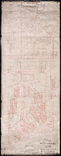
Plan of Lot 57
Description: Plan of Lot 57 (No.153). Selkirk Estate. Shows names of residents, acreage, and land conveyance references. A copy from the plan conveying the Estate to the Government and signed by John Aldous. The… more
Type: cadastral maps