Displaying 433 - 504 of 504
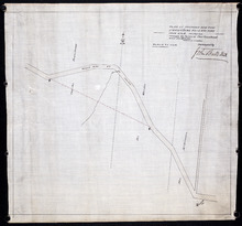
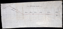
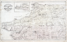
Plan of proposed new road straightening Rollo Bay Road, through the farms of Chas. Townshend and…
Description: Plan of proposed new road straightening Rollo Bay Road, through the farms of Chas. Townshend and Jos. Webster. The map shows lots, residents, and roads.
Province: Prince Edward Island
Type: cadastral maps
Proposed New Road from Rustico Road to Brookfield Road
Description: Proposed New Road from Rustico Road to Brookfield Road. The map shows lots, roads, residents, and a swamp.
Province: Prince Edward Island
Type: cadastral maps
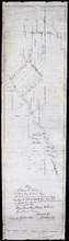
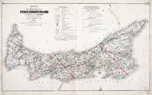
Plan showing the position of 2 new lines of road from R. McMillan's Mills to Fredericton…
Description: Plan showing the position of 2 new lines of road from R. McMillan's Mills to Fredericton Station. Also through McMillan's land from French Settlement. Also from Trout River Bridge to Road… more
Province: Prince Edward Island
Type: cadastral maps

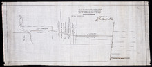
Plan of a proposed new line of road from Middleton Road to Isaac Ive's Millas coloured brown…
Description: Plan of a proposed new line of road from Middleton Road to Isaac Ive's Mill connecting with the road already opened from Searletown to Ive's Mill thro. part of Lot 27. The map shows lots,… more
Province: Prince Edward Island
Type: cadastral maps
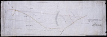
Plan Shewing the Situation of the Presen road from Point Prim Also the proposed road A.B.C.orD.
Description: Plan showing the situation of the present road from Point Prim. Also, the proposed one. The map shows lots, residents, water and foliage.
Province: Prince Edward Island
Type: cadastral maps
Plan of a new line of road from Victoria West to Western Road Lot 13 Prince Co. P.E.Island
Description: Plan of a new line of road from Victoria West to Western Road. Lot 13. The map shows lots, residents, roads, and rivers.
Province: Prince Edward Island
Type: cadastral maps
Plan of part of the Linklater Road, Lot 17
Description: Plan of part of the Linklater Road, Lot 17. (Linkletter Road) The map shows lots, residents, and roads.
Province: Prince Edward Island
Type: cadastral maps
Map of the Province of Prince Edward Island: in the Gulf of St. Lawrence
Description: The map shows the province of Prince Edward Island. Shown are tables of Explanations and Electorial Districts, a compass and the county lines are marked in red. Shown are gulfs, straits, bays, reefs… more
Publisher: J. H. Meacham & company
Province: Prince Edward Island
Type: cadastral maps
Date Created: 1880
Date Issued (Source): 1880

Plan of Lot One: Prince Co., P.E.I.
Description: Map showing the northWestern tip of the island. It names the gulfs, rivers, ponds, landowners and acreage, roads, and railroads. A graphic compass.
Publisher: J. H. Meacham & company
Province: Prince Edward Island
Type: cadastral maps
Date Issued (Source): 1880

Plan of Lot Six: Prince Co., P.E.I.
Description: Map showing lot six, bordering lots 5, 9, 10, 11 in Prince county. Shows rivers, creeks, railroads, roads, landowners, acreage, post offices, and buildings. Geographical compass
Publisher: J. H. Meacham & company
Province: Prince Edward Island
Type: cadastral maps
Date Issued (Source): 1880

Plan of Lots Two : Prince Co., P.E.I.
Description: Map showing lots 2
Publisher: J. H. Meacham & company
Province: Prince Edward Island
Type: cadastral maps
Date Issued (Source): 1880

Plan of Lot Seven: Prince Co., P.E.I.
Description: Map showing lot seven, bordering lots 4, 5, 6, and 8 in Prince county. Shows gulfs, railroads, roads, landowners, acreage, post offices, and buildings. Geographical compass
Publisher: J. H. Meacham & company
Province: Prince Edward Island
Type: cadastral maps
Date Issued (Source): 1880

Tignish, Prince Co.: Campbellton
Description: The map shows Lot 1 in Tignish, Prince county. Shown are roads, landowners and acreage, a church, chapel, and convent, a cemetery, railroad and station, grammar school, business, and houses. Compass.
Publisher: J. H. Meacham & company
Province: Prince Edward Island
Type: cadastral maps
Date Issued (Source): 1880
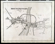
Mount Stewart: Lot 37
Description: The map shows lot 37 in Mount Stewart. Shown are roads, railroads and depot, landowners, houses, churches, Hillsborough river, wharfs, halls, and shipyard. Compass.
Publisher: J. H. Meacham & company
Province: Prince Edward Island
Type: cadastral maps
Date Issued (Source): 1880

Plan of Lot Four : Prince Co., P.E.I.
Description: Map showing lots four
Publisher: J. H. Meacham & company
Province: Prince Edward Island
Type: cadastral maps
Date Issued (Source): 1880

Plan of Lot Eight: Prince Co., P.E.I.
Description: The map shows lot 8 in Prince county. Shown are roads, landowners and acreage, rivers, Northumberland strait, ponds, lighthouses, post offices, churches, mills, and businesses. Compass.
Publisher: J. H. Meacham & company
Province: Prince Edward Island
Type: cadastral maps
Date Issued (Source): 1880

Plan of Lot Thirteen: Prince Co., P.E.I.
Description: Map showing lot thirteen, bordering lots 12, 14 and 15, in Prince county. Shows gulfs, straits, bays, rivers, ponds, creeks, railroads, roads, landowners, acreage, post offices, and buildings.… more
Publisher: J. H. Meacham & company
Province: Prince Edward Island
Type: cadastral maps
Date Issued (Source): 1880

Plan of Lot Nine: Prince Co., P.E.I.
Description: The map shows lot 9 in Prince county. Shown are roads, landowners and acreage, Egmont bay, sand, Brae river, post offices, railroad and station, schools and churches. Compass.
Publisher: J. H. Meacham & company
Province: Prince Edward Island
Type: cadastral maps
Date Issued (Source): 1880

Plan of Lot Fourteen & Sixteen : Prince Co., P.E.I.
Description: Map shows lots fourteen & sixteen in Prince county. Shown are roads, creeks, coves, rivers, post offices, railroads and stations, ferries, points, bays, landowners, acreage, churches, and… more
Publisher: J. H. Meacham & company
Province: Prince Edward Island
Type: cadastral maps
Date Issued (Source): 1880

Plan of Lot Ten: Prince Co., P.E.I.
Description: The map shows lot 10 in Prince county. Shown are roads, rivers and creeks, railroad and station, post offices, a school, and landowners and acreage. Compass.
Publisher: J. H. Meacham & company
Province: Prince Edward Island
Type: cadastral maps
Date Issued (Source): 1880

Plan of Lot Seventeen: Prince Co., P.E.I.
Description: The map shows lot 17 along with two smaller maps of lot 17 and 23. The map includes landowners and acreage, railroads and stations, roads, districts, creeks, rivers, bays, marshes, brooks, coves,… more
Publisher: J. H. Meacham & company
Province: Prince Edward Island
Type: cadastral maps
Date Issued (Source): 1880
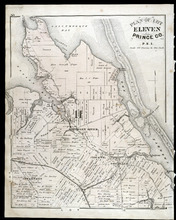
Plan of Lot Eleven: Prince Co., P.E.I.
Description: The map shows lot 11 in Prince county. Shown are roads, landowners and acreage, rivers, bays, coves, creeks, ponds, sand, railroad and station, post offices, and school houses. Compass.
Publisher: J. H. Meacham & company
Province: Prince Edward Island
Type: cadastral maps
Date Issued (Source): 1880

Plan of Lot Twenty One & Twenty: Queens Co., P.E.I.
Description: The map shows lots 21 and 20 (coloured in pink) in Queens county that border Prince county. The map names roads, landowners and acreage, creeks, gulfs, rivers, coves, fishing stations, post offices,… more
Publisher: J. H. Meacham & company
Province: Prince Edward Island
Type: cadastral maps
Date Issued (Source): 1880

Victoria, Lot 29; Map of Lennox Island
Description: The page displays map of Victoria in Lot 29. Shown are roads and streets, a harbour, wharfs, landowners, post offices, buildings and school houses. Compass. The page also displays a map of Lennox… more
Publisher: J. H. Meacham & company
Province: Prince Edward Island
Type: cadastral maps
Date Issued (Source): 1880
Plan of Lots 22 & 23 : Queens Co., P.E.I.
Description: The map shows lots 22 and 23 in Queens county. The map names roads, landowners and acreage, churches, halls, post offices, railroads, rivers, bays, and guls. Graphic compass.
Publisher: J. H. Meacham & company
Province: Prince Edward Island
Type: cadastral maps
Date Issued (Source): 1880
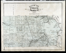
Plan of Lot Twelve: Prince Co., P.E.I.
Description: The map shows lot 12 in Prince county. Shown are the Narrows, roads, railroad and station, ponds, landowners and acreage, school houses, creeks, rivers, and coves.
Publisher: J. H. Meacham & company
Province: Prince Edward Island
Type: cadastral maps
Date Issued (Source): 1880
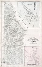
Plan of Lot Twenty Four: Queens Co., P.E.I.
Description: The map shows lot 24 in Queens county. Shown are rivers, gulfs, capes harbours, wharfs, lighthouses, fishing stages and holes, seaside hotels and bath houses, churches, crosses, post offices, roads,… more
Publisher: J. H. Meacham & company
Province: Prince Edward Island
Type: cadastral maps
Date Issued (Source): 1880
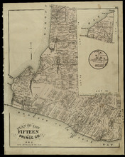
Plan of Lot Fifteen: Prince Co., P.E.I.
Description: The map shown is lot 15 in Prince county. Shown are byas, wharfs, landonwers and acreage, roads, post offices, villages, rivers, coves, a commissioners line, fishing coves, a court house, and stores… more
Publisher: J. H. Meacham & company
Province: Prince Edward Island
Type: cadastral maps
Date Issued (Source): 1880
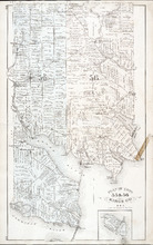
Plan of Lots Twenty Five & Twenty Six: Prince Co., P.E.I.
Description: The map shows lots 25 and 26 in Prince county. The map names roads, landowners and acreage, railroads, post offices, churches, harbours, lighthouses, hotels, coves. and rivers. Graphic compass.
Publisher: J. H. Meacham & company
Province: Prince Edward Island
Type: cadastral maps
Date Issued (Source): 1880
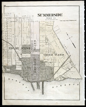
Summerside: Prince Co., P.E.I.
Description: The map shows the city of Summerside. Shown are the wards, a corportion line, landowners and acreage, roads, cemetery, buildings, railroad wharfs, and a harbour.
Publisher: J. H. Meacham & company
Province: Prince Edward Island
Type: cadastral maps
Date Issued (Source): 1880

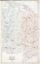
Plan of Lot Twenty Seven: Prince Co., P.E.I.
Description: The map shows lot 27 in Prince county. The map shows roads, railroads, crosses, ponds, rivers, bays, straits, coves, mills, post offices, and churhces. Graphic compass.
Publisher: J. H. Meacham & company
Province: Prince Edward Island
Type: cadastral maps
Date Issued (Source): 1880
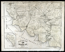
Plan of Lot 28: Prince Co., P.E.I.
Description: The map shows lot 28 in Prince county. Shown are straits, coves, rivers, Anglo-American cable, Winter Crossing Ice Boats, post offices, churches, landowners and acreage, and factories. Compass.
Publisher: J. H. Meacham & company
Province: Prince Edward Island
Type: cadastral maps
Date Issued (Source): 1880
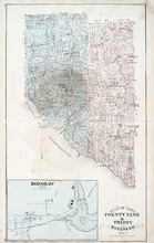
Plan of Lots Twenty Nine & Thirty: Queens Co., P.E.I.
Description: The map shows lots 29 (coloured in blue) and 30 (coloured in pink) in Queens county. The map shows straits, rivers, post offices, roads, landowners and acreage, and churches. Graphic compass.
Publisher: J. H. Meacham & company
Province: Prince Edward Island
Type: cadastral maps
Date Issued (Source): 1880
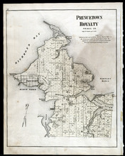
Princetown Royalty: Prince Co., P.E.I.
Description: The map shows Princetown Royalty, in Prince county. Shown are Bays, a basin, rivers, commons, sand, points, wharfs, churches, cemetery, post offices, roads, and landowners.
Publisher: J. H. Meacham & company
Province: Prince Edward Island
Type: cadastral maps
Date Issued (Source): 1880
Plan of Lot Thirty One: Queens Co., P.E.I.
Description: The map shows lot 31 in Queens county. Shown are rivers, landowners and acreage, post offices, creeks, railroads and stations, roads, churches, a ferry, and school houses. Compass. Illustrated… more
Publisher: J. H. Meacham & company
Province: Prince Edward Island
Type: cadastral maps
Date Issued (Source): 1880
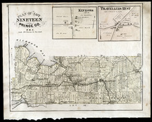
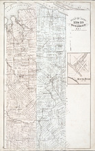
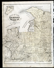
Plan of Lot Nineteen: Prince Co., P.E.I.
Description: The map shows lot 19 in Prince county. Shown are creeks, bays, roads, railroads and stations, landowners and acerage, post offices and buildings. Compass.
Publisher: J. H. Meacham & company
Province: Prince Edward Island
Type: cadastral maps
Date Issued (Source): 1880
Plan of Lots 33 & 34: Queens Co., P.E.I.
Description: The map shows lots 33 (coloured in blue) & 34 (coloured in pink) in Queens county. The map shows roads, railroads and stations, landowners and acreage, farms, post offices, churches, hotels,… more
Publisher: J. H. Meacham & company
Province: Prince Edward Island
Type: cadastral maps
Date Issued (Source): 1880
Plan of Lot Eighteen: Prince Co., P.E.I.
Description: The map shows lot 18 in Prince county. Shown are bays, capes, points, coves, post offices, schools, creeks, mills, churches, landowners and acreage, and roads. Compass.
Publisher: J. H. Meacham & company
Province: Prince Edward Island
Type: cadastral maps
Date Issued (Source): 1880
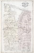
Plan of Lot Thirty Five & Thirty Six: Queens Co., P.E.I.
Description: The map shows lots 35 & 36 in Queens county. Shown are gulfs, bays, sand, coves, wharfs, rivers, ponds, creeks, fishing houses, roads, landowners and acreage, post offices, school houses,… more
Publisher: J. H. Meacham & company
Province: Prince Edward Island
Type: cadastral maps
Date Issued (Source): 1880
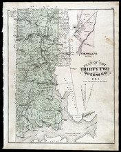
Plan of Lot Thirty Two: Queens Co., P.E.I.
Description: The map shows lot 32 in Queens county. Shown are roads, landowners and acreage, railroad and station, post offices, rivers, churches, and coves. Compass.
Publisher: J. H. Meacham & company
Province: Prince Edward Island
Type: cadastral maps
Date Issued (Source): 1880

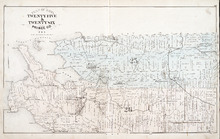
Plan of Lot Thirty Seven : Plan of Lot Thirty Eight: Queens Co., P.E.I.. Kings Co., P.E.I.
Description: The map shows lot 37 (coloured in pink) in Queens county, and lot 38 (coloured in blue) in Kings county. Shown are roads, railroads, landowners and acreage, rivers, ponds, harbours, gulfs, creeks,… more
Publisher: J. H. Meacham & company
Province: Prince Edward Island
Type: cadastral maps
Date Issued (Source): 1880
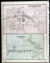
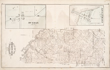
Kensington, Lot 19: St. Peters, Lot 41
Description: The map shows lot 19 in Kensington. Shown are a school house, a hall, roads, landowners, railroad and depot grounds, businesses and churches. Compass.
Publisher: J. H. Meacham & company
Province: Prince Edward Island
Type: cadastral maps
Date Issued (Source): 1880
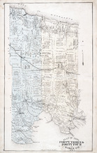
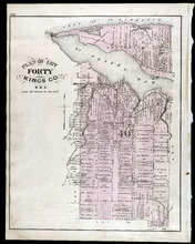
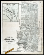
Plan of Lots Fourty Three & Fourty Four: Kings Co., P.E.I.
Description: The map shows lots 43 & 44 in Kings county. Shown are bays, gulfs, rivers, coves, capes, roads, railroads and stations, landowners and acreage, crosses, post offices, churches, and factories.… more
Publisher: J. H. Meacham & company
Province: Prince Edward Island
Type: cadastral maps
Date Issued (Source): 1880
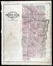
Plan of Lot Thirty Nine: Kings Co., P.E.I.
Description: The map shows lot 39 in Kings county. Shown are a gulf, lake, sand, light house, post offices, landowners and acreage, roads, railroads and stations, rivers, school houses, churches, and an Indian… more
Publisher: J. H. Meacham & company
Province: Prince Edward Island
Type: cadastral maps
Date Issued (Source): 1880
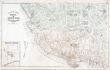
Plan of Lot Fourty Eight: Queens Co., P.E.I.
Description: The map showing lots 48 in Queens county. Shown are the commissioners line, rivers, coves, marsh, creeks, ponds, lakes, roads, landowners and acreage, asylum, hospital, and post offices. Graphic… more
Publisher: J. H. Meacham & company
Province: Prince Edward Island
Type: cadastral maps
Date Issued (Source): 1880
Plan of Lot Fourty: Kings Co., P.E.I.
Description: The map shows Lot 40 in Kings county. Shown are a bay, gulf, river, ponds, school house, churches, wharf, post office, roads, landowners and acreage, and mills. Compass.
Publisher: J. H. Meacham & company
Province: Prince Edward Island
Type: cadastral maps
Date Issued (Source): 1880
Plan of Lots 49 & 50: Queens Co., P.E.I.
Description: The map shows lot 49 & 50 in Queens County. Shown are roads, landowners and acreage, lakes, bays, coves, wharfs, post offices, churches, and schools. Graphic compass
Publisher: J. H. Meacham & company
Province: Prince Edward Island
Type: cadastral maps
Date Issued (Source): 1880
Plan of Lot Forty One: Kings Co., P.E.I.
Description: The map shows lot 41 in Kings county. Shown are St. Peters bay, river, gulf, roads, landowners and acreage, railroad and station, post offices, mills, schools, and churches. Compass.
Publisher: J. H. Meacham & company
Province: Prince Edward Island
Type: cadastral maps
Date Issued (Source): 1880
Plan of Lots 51, 52, & 66: Kings Co., P.E.I.
Description: The map shows lots 51, 52, & 66 in Kings county. Shown are roads, railroads and stations, landowners and acreage, streams, rivers, post offices, mills, and churches. Graphic compass.
Publisher: J. H. Meacham & company
Province: Prince Edward Island
Type: cadastral maps
Date Issued (Source): 1880
Plan of Lot Forty Two: Kings Co., P.E.I.
Description: The map shows lot 42 in Kings county. Shown are a gulf, marsh, roads, railroad and stations, post offices, school houses, rivers, and a brook. Compass.
Publisher: J. H. Meacham & company
Province: Prince Edward Island
Type: cadastral maps
Date Issued (Source): 1880
Plan of Lots Fifty Three & Fifty Four: Kings Co., P.E.I.
Description: The map shows lots 53 & 54 in Kings county. Shown are roads, railroads and stations, landowners and acreage, rivers, creeks, wharfs, post offices, and mills. Graphic compass.
Publisher: J. H. Meacham & company
Province: Prince Edward Island
Type: cadastral maps
Date Issued (Source): 1880
Plan of Lot Fourty Five: Kings Co., P.E.I.
Description: The map shows Lot 45 in Kings county. Shown are the gulf, bay, rivers, coves, post offices, cross, mills, roads, railroad, landowners and acreage, churches, hospital, harbour, and sand. Compass.
Publisher: J. H. Meacham & company
Province: Prince Edward Island
Type: cadastral maps
Date Issued (Source): 1880
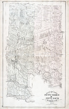
Plan of Lots 55 & 56: Kings Co., P.E.I.
Description: The map shows lots 55 & 56 in Kings county. Shown are roads, landowners and acreage, crosses, rivers, ponds, creeks, bays, coves, sand, wharfs, mills, post offices, churches, schools, and… more
Publisher: J. H. Meacham & company
Province: Prince Edward Island
Type: cadastral maps
Date Issued (Source): 1880
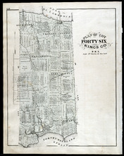
Plan of Lot Fourty Six: Kings Co., P.E.I.
Description: The map shows lot 46 in Kings county. Shown are a gulf, straits, pond, roads, landowners and acreage, school houses, post offices, mills, and sand. Compass.
Publisher: J. H. Meacham & company
Province: Prince Edward Island
Type: cadastral maps
Date Issued (Source): 1880
Plan of Lots Fifty Seven & Fifty Eight: Queens Co., P.E.I.
Description: The map shows lots 57 & 58 in Queens county. Includes an inset map of Prim Island / Point Prim. Shown are roads, landowners and acreage, crosses, rivers, ponds, creeks, bays, coves, sand, wharfs… more
Publisher: J. H. Meacham & company
Province: Prince Edward Island
Type: cadastral maps
Date Issued (Source): 1880
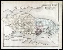
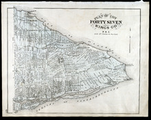
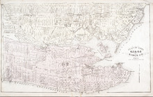
Georgetown Royalty and Reserve Land: Kings Co., P.E.I.
Description: The map shows Georgetown Royalty and Reserve Land in Kings county. Shown are rivers, roads, railroads and stations, landowners and acreage, beaches, Georgetown commons, square, market, court house,… more
Publisher: J. H. Meacham & company
Province: Prince Edward Island
Type: cadastral maps
Date Issued (Source): 1880
Plan of Lots 59 & 61: Kings Co., P.E.I.
Description: The map shows lots 59 & 61 in Kings county. Shown are roads, landowners and acreage, crosses, rivers, ponds, creeks, bays, coves, sand, wharfs, mills, post offices, churches, schools, light… more
Publisher: J. H. Meacham & company
Province: Prince Edward Island
Type: cadastral maps
Date Issued (Source): 1880
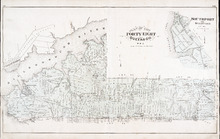
Plan of Lot Forty Seven: Kings Co., P.E.I.
Description: The map shows Lot 47 in Kings county. Shown are a gulf, straits, rivers, lakes, swamp, sand, fishing huts, mills, post offices, churches, creeks, light house, and pond. Compass.
Publisher: J. H. Meacham & company
Province: Prince Edward Island
Type: cadastral maps
Date Issued (Source): 1880
Plan of Lot Sixty & Sixty Two: Queens Co., P.E.I.
Description: The map shows lots 60 & 62 in Queens county. Shown are roads, landowners and acreage, rivers, straits, ponds, bays, creeks, sand, post offices, mills, churches, and school houses. Graphic compass.
Publisher: J. H. Meacham & company
Province: Prince Edward Island
Type: cadastral maps
Date Issued (Source): 1880
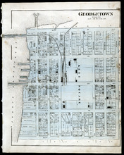
Georgetown: Kings Co., P.E.I.
Description: The map shows Georgetown in Kings county. Shown are wharfs, harbour, roads and streets, railroads and stations, landowners, houses, court house, scholl house, drill shed, Georgetown square, churches… more
Publisher: J. H. Meacham & company
Province: Prince Edward Island
Type: cadastral maps
Date Issued (Source): 1880
Plan of Lots 63 & 64: Kings Co., P.E.I.
Description: The map shows Lots 63 & 64 in Kings county. Shown are roads, landowners and acreage, crosses, rivers, straits, ponds, gulfs, marshes, coves, wharfs, post offices, mills, churches, factories, and… more
Publisher: J. H. Meacham & company
Province: Prince Edward Island
Type: cadastral maps
Date Issued (Source): 1880
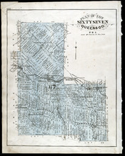
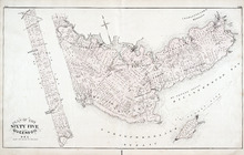
Plan of Lot Sixty Seven: Queens Co., P.E.I.
Description: The map shows Lot 67 in Queens county. Shown are roads, landowners and acreage, railroads and stations, post offices, church, and school houses. Compass.
Publisher: J. H. Meacham & company
Province: Prince Edward Island
Type: cadastral maps
Date Issued (Source): 1880
Plan of Lot 65 : Queens Co., P.E.I.
Description: The map shows Lot 65 in Queens county. Shown are roads, landowners and acreage, creeks, rivers, straits, marshes, brooks, coves, sand, reef, fishing stage, wharfs, post offices, mills, churches,… more
Publisher: J. H. Meacham & company
Province: Prince Edward Island
Type: cadastral maps
Date Issued (Source): 1880
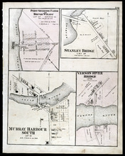
Port Selkirk Farm or Brush Wharf, Stanley Bridge: Murray Harbour South, and Vernon River Bridge
Description: The map shows Port Selkirk Farm or Brush Wharf lot 57 in Queens county. Shown are a river, wharf, road and street, landowners, and measurements. Compass.
Publisher: J. H. Meacham & company
Province: Prince Edward Island
Type: cadastral maps
Date Issued (Source): 1880
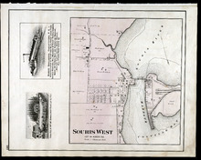
Souris West Lot 44: Kings Co., P.E.I.
Description: The map shows Lot 44 in Souris West, Kings county. Shown are a bay, harbour, river, railroad, landowners, roads, houses and buildings, school houses, businesses, and shipyards. Compass.
Publisher: J. H. Meacham & company
Province: Prince Edward Island
Type: cadastral maps
Date Issued: 1880
Date Issued (Source): 1880
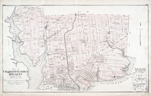
Plan of Charlottetown Royalty: Queens Co., P.E.I.
Description: The map shows the city of Charlottetown and a plan for lots. Shown are rivers, creeks, roads, railroad and stations, landowners and acreage, mills, park, bridge, college, farms, asylums, and a… more
Publisher: J. H. Meacham & company
Province: Prince Edward Island
Type: cadastral maps
Date Issued (Source): 1880
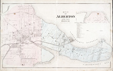
Map of Alberton Lots 4 & 5: Prince Co., P.E.I.
Description: The map shows lots 4 & 5 in the town of Alberton, Prince county. Shown are rivers, creeks, lakes, wharfs, shipyard, roads, railroad, landowners and acreage, mills, churches and cemetery. Compass… more
Publisher: J. H. Meacham & company
Province: Prince Edward Island
Type: cadastral maps
Date Issued (Source): 1880
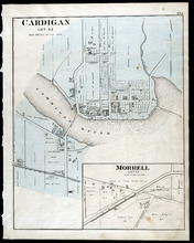
Cardigan Lot 53: Morrell Lot 40
Description: The map shows lot 53 in Cardigan. Shown are a river, roads, railroads, lots, landowners, school house, buildings, houses, wharfs and creeks. Compass.
Publisher: J. H. Meacham & company
Province: Prince Edward Island
Type: cadastral maps
Date Issued (Source): 1880

Montague Bridge Lots 59 & 52: Kings Co., P.E.I.
Description: The map shows lots 59 & 52 in Montague Bridge, Kings county. Shown are rivers, wharfs, shipyards, roads, landowners and acreage, halls, churches, buildings and businesses. Compass.
Publisher: J. H. Meacham & company
Province: Prince Edward Island
Type: cadastral maps
Date Issued (Source): 1880
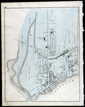
Souris
Description: The map shows a part of Souris. Shown are the Souris river, sand beach, roads, railroads, churhces, landowners, houses, buildings and businesses. Compass
Publisher: J. H. Meacham & company
Province: Prince Edward Island
Type: cadastral maps
Date Issued (Source): 1880
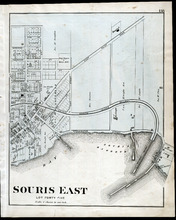
Souris East: Lot Forty Five
Description: The map shows Lot 45 in Souris East. Shown are the Souris Harbour and Bay, wharfs, roads and streets, railroads, lobster factory, landowners, houses, buildings and businesses. Compass
Publisher: J. H. Meacham & company
Province: Prince Edward Island
Type: cadastral maps
Date Issued (Source): 1880
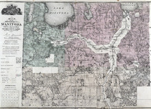
Map of the Province of Manitoba
Description: The map shows the province of Manitoba. Shown on the side are a Reference table and a Township diagram, lakes, roads, marshes, Indian Reserves, churches, rivers, and ponds. Compass.
Publisher: J. H. Meacham & company
Province: Manitoba
Type: cadastral maps
Date Issued (Source): 1880