Displaying 109 - 135 of 992
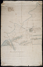
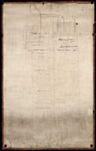
Eastern Division of Township No. 28
Description: Sketch of the eastern division of Lot 28 (No.33). DeBlois Estate.
Province: Prince Edward Island
Type: cadastral maps
Date Created: 1870-01-01
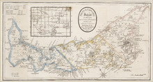
Prince Edward Island: divided into Counties & Parishes, with the Lots, as Granted by Government…
Description: Prince Edward Island divided into Counties and Parishes with the Lots as granted by Government, exhibiting all the New Settlements, Roads, Mills, etc. Published by H. Ashby, King Street, Cheapside,… more
Publisher: Ashby, H.
Province: Prince Edward Island
Type: cadastral maps
Date Created: 1798-03-01

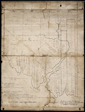
Plan of Township No. 29: embracing the Fane and Melville Estates – 1883
Description: Plan of Lot 29 (No.80). Fane and Melville Estates.
Province: Prince Edward Island
Type: cadastral maps
Date Created: 1883

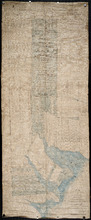
Plan of Township 30
Description: Plan of Lot 30 (No.82). Stewart Estate. Shows names of residents.
Province: Prince Edward Island
Type: cadastral maps
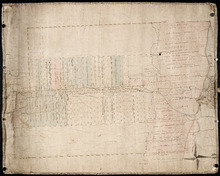
Lot 31: Southern portion
Description: Plan of the southern part of Lot 31, showing residents. In use 1819. From H.J. Cundall.
Province: Prince Edward Island
Type: cadastral maps

Lot 32
Description: Plan of Lot 32 showing some residents.
Province: Prince Edward Island
Type: cadastral maps

Plan of Township No. 33 in Prince Edward Island: Part of the Estate of John Hodges Winsloe Esq.…
Description: Plan of Lot 33. Winsloe Estate.
Province: Prince Edward Island
Type: cadastral maps
Date Created: 1834-09-20

Lot 34: Southern portion
Description: Part of Lot 34 (No.7). North side of Hillsborough River.
Province: Prince Edward Island
Type: cadastral maps

Plan of Lot 38
Description: Plan of Lot 38 showing the extent of land in possession of the Government...(?)
Province: Prince Edward Island
Type: cadastral maps

Plan of Lot or Township No. 39: from the lastest Surveys by Joseph Ball, S.G., July 1, 1857
Description: Plan of Lot 39 (No.104). Worrell Estate. Plan copied by Owen Curtis, 1876.
Province: Prince Edward Island
Type: cadastral maps
Date Created: 1857-07-01

Plan of Lot or Township No. 40: From latest Surveys by Joseph Ball and Owen Curtis, Land Surveyors.
Description: Plan of Lot 40 (No.109). Worrell Estate.
Province: Prince Edward Island
Type: cadastral maps

Plan of Lot or Township No. 41: From The Latest Surveys By Joseph Ball S.G., Copied by O. Curtis
Description: Plan of Lot 41 (No.111). Showing residents. Surveyed by Joseph Ball. Plan copied by Owen Curtis.
Province: Prince Edward Island
Type: cadastral maps

Lot 43: No. 1
Description: Plan of Lot 43 (No.1), showing Bay Fortune, Rollo Bay and North Shore areas.
Province: Prince Edward Island
Type: cadastral maps
Lot 43: Plan of that part of Division No. 1 Shaded Green on Lot or Township No. 43 containing 3467…
Description: Plan of that part of Lot 43 containing 3467 acres purchased by the Government.
Province: Prince Edward Island
Type: cadastral maps
Part of Lot 43
Description: Plan of part of Lot 43 (No.117). Townshend Estate.
Province: Prince Edward Island
Type: cadastral maps
Plan of Lot 44
Description: Plan of Lot 44. Old plan referred to in deed from Sir Ed. Cunard and others to the Commissioner for Public Lands, dated 13 July, 1866.
Province: Prince Edward Island
Type: cadastral maps
Date Created: 1866
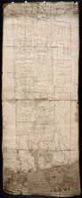
Plan of Lot 45: Northern portion
Description: Plan of the northern part of Lot 45 (No.123), showing the names of some residents.
Province: Prince Edward Island
Type: cadastral maps

Plan of Township No. 64: St. Andrews Parish, Queens County, P. E. Island
Description: Lot 64 is situated in Kings County, not Queens County as stated in the map title. The map shows Lot 64 divided into parcels of land with names of residents and their acreage amounts. Several parcels… more
Province: Prince Edward Island
Type: cadastral maps
Date Created: 1850

Plan of the Western Portion of Township No. 65: containing 5250 acres and belonging to Mrs. Lydia…
Description: Plan of the western portion of Lot 65 (No.173). Estate of Mrs Lydia Wright. Roads, leased land[?] and freehold land on the Estate of Mrs. Lydia Wright. Tenant names appear on the sub-lots, which are… more
Province: Prince Edward Island
Type: cadastral maps
Date Created: 1841

Plan of Lot or Township No. 34
Description: Plan of Lot 34 (No. 90). Montgomery Estate. Working plan. The map shows Lot 34 divided into parcels of land with the names of residents and their acreage amounts handwritten in black ink. Land… more
Province: Prince Edward Island
Type: cadastral maps
Plan of the Division Line between Queens and Prince Counties & the Southern Boundary of…
Description: Plan of the division line between Queens and Prince Counties and the southern boundary of Lot 25 established by the Commissioners under the Boundary Line Act. Certified copy by G. Wright of 1835 plan… more
Province: Prince Edward Island
Type: boundary maps
Date Created: 1850
Plan of the Division Line between Queens and Prince Counties, & the Southern Boundary of…
Description: Plan of the division line between Queens and Prince Counties and the southern boundary of Lot 25, as established by the Commissioners under the Boundary Line Act. (No.81). The map shows the boundary… more
Province: Prince Edward Island
Type: boundary maps
Date Created: 1835
Plan of the Line dividing Kings and Queens Counties in Prince Edward Island as established by the…
Description: Plan of the line dividing Kings and Queens Counties in Prince Edward Island as established by the Commissioners under the provisions of the Act 4th: William 4th: Cap. 15 (No. 80). The map shows the… more
Province: Prince Edward Island
Type: boundary maps
Date Created: 1835

Office copy of that part of the Plan of the new line of Road leading from the Cardigan River to the…
Description: Plan of the new line of road leading from the Cardigan River to the Hillsborough River. Passes through Lots 51, 52, and 38. Plan copied by Geo. Wright, 12 August, 1837. The plan uses a dashed and… more
Province: Prince Edward Island
Type: engineering maps
Date Created: 1833
Plan of land appropriated by the Railway Commissioners in Lots 38 and 51
Description: Prince Edward Island Railway. Plan shows the land appropriated by the Railway Commissioners in Lots 38 and 51. The rail line is drawn in pink. Roads are shown in a lighter colour. Names of residents… more
Province: Prince Edward Island
Type: engineering maps
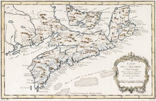
Carte de l'Accadie et Païs Voisins pour servir a l'Histoire Generale des Voyages: Par M.B…
Description: Rectangular map engraved on paper; framed and covered with glass. Coloured. Depicts Nova Scotia, P.E.I., Cape Breton, and part of New Brunswick; all place names in French. Highland areas in brown.… more
Province: Nova Scotia, New Brunswick, Prince Edward Island
Type: chorographic maps
Date Created: 1757