Displaying 514 - 533 of 533
Charlottetown, P.E.I.: July 1903.
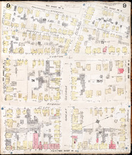
Description: This is Page 9 of 20 pages of fire insurance maps of Charlottetown. It was created in 1903 and revised to either 1910 or 1917. It shows the area from Passmore Street to Kent Street, between Queen and… more
Publisher: Chas. E. Goad, Civil Engineer
Province: Prince Edward Island
Type: fire insurance maps
Date Created: 1903-07
Date Modified: 1910-08, 1917-07 (year and month uncertain)
Date Issued (Source): 1888
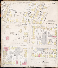
Charlottetown P.E.I.: July 1903
Description: This is Page 10 of 20 pages of fire insurance maps of Charlottetown. It was created in 1903 and revised to either 1910 or 1917. It shows the area from just north of Euston Street, south to Kent… more
Publisher: Chas. E. Goad, Civil Engineer
Province: Prince Edward Island
Type: fire insurance maps
Date Created: 1903-07
Date Modified: 1910-08, 1917-07 (year and month uncertain)
Date Issued (Source): 1888
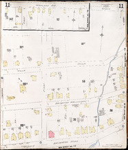
Charlottetown P.E.I.: July 1917. Reprinted
Description: This item, Page 11 of 20 pages of fire insurance plans of Charlottetown, consists of two (2) maps. The main map shows the area from Green Street to Brighton Road, between Greenfield Avenue (Second)… more
Publisher: Chas. E. Goad, Civil Engineer
Province: Prince Edward Island
Type: fire insurance maps
Date Created: 1917-07
Date Issued (Source): 1888
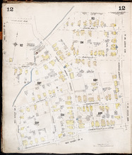
Charlottetown P.E.I.: July, 1903.
Description: This is Page 12 of 20 pages of fire insurance maps of Charlottetown. It was created in 1903 and revised to either 1910 or 1917. It shows the area from Douglas Street to Churchill Avenue and Chestnut… more
Publisher: Chas. E. Goad, Civil Engineer
Province: Prince Edward Island
Type: fire insurance maps
Date Created: 1903-07
Date Modified: 1910-08, 1917-07 (year and month uncertain)
Date Issued (Source): 1888
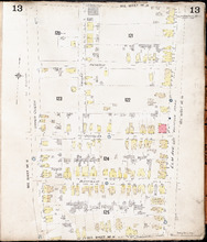
Charlottetown P.E.I.: July, 1903.
Description: This is Page 13 of 20 pages of fire insurance maps of Charlottetown. It was created in 1903 and revised to either 1910 or 1917. It shows the area bounded by Connolly Street in the north, Elm Avenue/… more
Publisher: Chas. E. Goad, Civil Engineer
Province: Prince Edward Island
Type: fire insurance maps
Date Created: 1903-07
Date Modified: 1910-08, 1917-07 (year and month uncertain)
Date Issued (Source): 1888
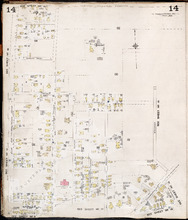
Charlottetown P.E.I.: July, 1903.
Description: This is Page 14 of 20 pages of fire insurance maps of Charlottetown. It was created in 1903 and revised to either 1910 or 1917. It shows the area from Allan (Allen) Street, in the north, to (… more
Publisher: Chas. E. Goad, Civil Engineer
Province: Prince Edward Island
Type: fire insurance maps
Date Created: 1903-07
Date Modified: 1910-08, 1917-07 (year and month uncertain)
Date Issued (Source): 1888
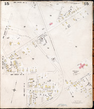
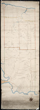
Charlottetown, P.E.I.: July, 1903.
Description: This is Page 15 of 20 pages of fire insurance maps of Charlottetown. It was created in 1903 and revised to either 1910 or 1917. The map shows part of the eastern portion of early twentieth-century… more
Publisher: Chas. E. Goad, Civil Engineer
Province: Prince Edward Island
Type: fire insurance maps
Date Created: 1903-07
Date Modified: 1910-08, 1917-07 (year and month uncertain)
Date Issued (Source): 1888

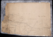
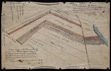
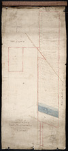
Plan of part of the Railway appropriations in Lot 45: Harmony Station
Description: Plan of part of the Railway appropriations in Lot 45. Harmony Station. The map shows roads, residents and acreage.
Province: Prince Edward Island
Type: cadastral maps
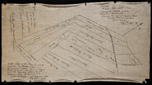
Plan of Lot No. 38 [? title partly missing]
Description: Plan of part of Lot 38 and part of Lot 39. Savage Harbour area. The map shows northern portions of Lot 38 and Lot 39 divided into parcels of land with names of residents and acreage amounts. It shows… more
Province: Prince Edward Island
Type: cadastral maps
Untitled
Description: Unfinished plan of Lot 45. The map shows some lots, residents, and bodies of water.
Province: Prince Edward Island
Type: cadastral maps

Lot No. 46
Description: Plan of Lot 46 (No.1) divided into two parts and drawn for in Council, Oct. 24, 1786. The map shows Lot 46 divided into two parts--Division No. 1 (west) and Division No. 2 (east)--of 10,000 acres… more
Province: Prince Edward Island
Type: cadastral maps
Date Created: 1786-10-24
Plan of the Northern Moiety of Lot 45: compiled from surveys made by L.N. Gall and H.J. Cundall.
Description: Plan of the northern moiety of Lot 45 compiled from surveys made by L.N. Gall and H.J. Cundall. Plan referred to in deed to Commissioner of Public Land, dated 13th July, 1866. The map of the northern… more
Province: Prince Edward Island
Type: cadastral maps
Date Created: 1866
Plan of part of Lot 47: The Estate of the late Alexander McDonald showing allotments pursuant to…
Description: Plan of part of Lot 47. The estate of the late Alexander McDonald showing allotments pursuant to Order of Supreme Court Schedule G. The map shows the estate of the late Alexander McDonald divided… more
Province: Prince Edward Island
Type: cadastral maps
Date Created: 1885-07-07
Plan of part of Lot 47: The estate of the late Alexander McDonald showing the different kinds of…
Description: Plan of part of Lot 47. The estate of the late Alexander McDonald showing the different kinds of land. Schedule F. The map, drawn in black ink, shows the estate of the late Alexander McDonald divided… more
Province: Prince Edward Island
Type: cadastral maps
Date Created: 1885-07-07

Plan of the Northern Moiety of Lot or Township No. 48 in Prince Edward Island, Copied from the Plan…
Description: Plan of the northern moiety of Lot 48 (No.129). Shows the property of Miss Frances Crooke, R.G. Cuninghame, Theo. Desbrisay, and the Misses Lawton. The map shows lots, residents, roads, and bodies of… more
Province: Prince Edward Island
Type: cadastral maps
Date Created: 1836

Plan of Township No. 50 The Estate of the Misses[?] Fanning, Prince Edward Island: From actual…
Description: Plan of Lot 50. Fanning Estate. The map shows lots, residents, bodies of water and roads.
Province: Prince Edward Island
Type: cadastral maps
A Plan of the Eastern or C Division of Lot or Township No. 51: St. Georges Parish, Kings Coutnry, P…
Description: Plan of the eastern division of Lot 51. Montgomery Estate. The map shows the C Division of Lot 51 divided into numbered parcels of land with the names of owners or occupants with their corresponding… more
Province: Prince Edward Island
Type: cadastral maps

Plan of Lot or Township No. 51 in Kings County Prince Edward Island: Surveyed by G. Wright Jr. in…
Description: Plan of Lot 51 (No.141). Shows residents, lots, bodies of water such as rivers, and roads.
Province: Prince Edward Island
Type: cadastral maps
Date Created: 1836

Plan of Lot 57
Description: Plan of Lot 57 (No.2) showing the lot divided into quarters. Also shows Refugee Share drawn for in Council, 12 February, 1784.
Province: Prince Edward Island
Type: cadastral maps
Date Created: 1784-02-12

A Plan of the undisposed of Parts of Lot No. 57: in Queens County in Prince Edward Island
Description: A plan of the undisposed of parts of Lot 57. Surveyed by Rod'k Campbell. The map shows parcels of land with names of owners or occupants and their corresponding acreage amounts handwritten in… more
Province: Prince Edward Island
Type: cadastral maps
Date Created: 1860