Displaying 28 - 54 of 204

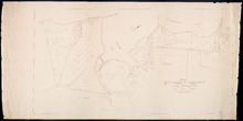
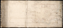
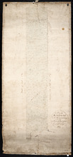
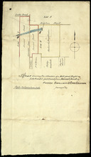
Plan Alterations of Railway on Lot 17 and Station Grounds at Summerside.
Description: Plan of Alterations of the Railway on Lot 17 and the Station Grounds at Summerside. The map shows lots, residents, streets, wharfs, and buildings.
Province: Prince Edward Island
Type: cadastral maps
Date Created: 1872-10-10
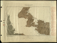
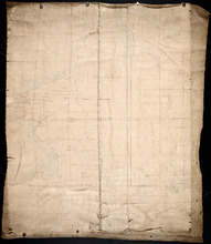
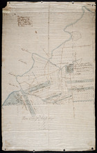
Map of Southport and Rosebank, Prince Edward Island: Drawn by C.D. Lambown Sept. 26, 1953
Description: Map of Southport and Rosebank, Lot.48. Shows names of residents, acreage, cities and towns, and Hillsborough River.
Province: Prince Edward Island
Type: cadastral maps
Date Created: 1953-09-26

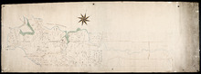
Map of Prince Edward Island
Description: Map of Prince Edward Island showing school districts(?). The map shows bodies of water and town and cities.
Province: Prince Edward Island
Type: cadastral maps, thematic maps
Date Created: 1971-02-05
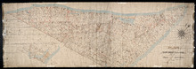
Prince Edward Island
Description: Prince Edward Island. Geological Survey of Canada. The map shows Prince county, roads, bodies of water, cities and towns.
Province: Prince Edward Island
Type: geological maps
Date Created: 1884
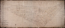
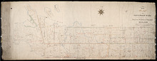
Plan of the Cunard and Palmer Estates in Lot or Township No.1.
Description: Plan of Lot 1 (No.1). Cunard and Palmer Estates. Drawn by Owen Curtis. Shows names of residents, acreage, and a few land conveyance references, and roads.
Province: Prince Edward Island
Type: cadastral maps
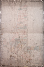
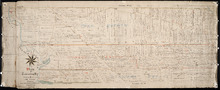
Plan of Township No 15: Taken from the survey of William Cutis (1826) wit alterations and…
Description: Plan of Lot 15 (No.42) taken from the survey of William Curtis (1826) with alterations and corrections from surveys made in 1849 and 1851 by Geo. Wright. Color code shows Crown Lands and lands… more
Province: Prince Edward Island
Type: cadastral maps
Date Created: 1851
Plan of Lot or Township No. 6 in Prince Edward Island: From Actual Survey by A. Anderson, Land…
Description: Plan of Lot 6. Northern half shows residents.
Province: Prince Edward Island
Type: cadastral maps
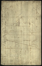
A Plan of Lot 18: situated in Prince County in the Island of St. John enlarged and Drawn from the…
Description: Sketch plan of Lot 18 (Plan No.46) showing property of Peter Stewart, Robert Stewart, and Wm. Allanby. Surveyed by Thomas Wright. Office copy by Jos. Ball and certified by Geo. Wright. Original was… more
Province: Prince Edward Island
Type: cadastral maps
Date Created: 1847-04-06
Plan of Township No. 26: Comprising the Holland, Stephens, and Thomson Estates Copied from the…
Description: Plan of Lot 26 (No.70) comprising the Holland, Stephens, and Thomson Estates copied from the plans in Public Lands Department, corrected by partial surveys and Meacham's Atlas. more
Province: Prince Edward Island
Type: cadastral maps
Date Created: 1885-09
Plan of Township 27: embracing Freeholds and the Pope and Cunard Estates. Compiled from Meacham…
Description: Plan of Lot 27 (No.73) embracing freeholds and the Pope and Cunard Estates. Compiled from Meacham's Atlas and the original leases. more
Province: Prince Edward Island
Type: cadastral maps
Date Created: 1885-09
A Plan of the Northern half Lot or Township No. 27 in Prince Edward Island: from an Actual Survey…
Description: Outline plan of northern half of Lot 27 (No.2).
Province: Prince Edward Island
Type: cadastral maps
Date Created: 1818
Eastern Division of Township No. 28
Description: Sketch of the eastern division of Lot 28 (No.33). DeBlois Estate.
Province: Prince Edward Island
Type: cadastral maps
Date Created: 1870-01-01
Plan of the Division Line between Queens and Prince Counties, & the Southern Boundary of…
Description: Plan of the division line between Queens and Prince Counties and the southern boundary of Lot 25, as established by the Commissioners under the Boundary Line Act. (No.81). The map shows the boundary… more
Province: Prince Edward Island
Type: boundary maps
Date Created: 1835


Plan of Township No. 9: compiled from the proprietors' plans and the descriptions in the…
Description: Plan of Lot 9 compiled from the proprietors plans and the descriptions in the leases and deeds, with additions and corrections from the various surveys. The map shows Lot 9 divided into parcels of… more
Province: Prince Edward Island
Type: cadastral maps
Date Created: 1909

Plan of Township No. 11: compiled from the plans by the late Alexander Anderson L. S on file in the…
Description: The map shows Lot 11 divided into parcels of land with names of residents, their acreage amounts and land conveyance references. Shows the P.E.I. Railway in red, roads in light brown. Bodies of water… more
Province: Prince Edward Island
Type: cadastral maps
Date Created: 1910
Plan of Lot 1
Description: Plan of Lot 1 comprising the Palmer and part of the Cunard Estates. Surveyed by V.S. Gillis and others. Rolled map on fabric backing. Water is coloured blue. Properties include owner / occupant names… more
Province: Prince Edward Island
Type: cadastral maps
Date Created: Unknown year


Plan of Township No. 13: From a Survey by Alex Anderson Copied from a Plan made by John Clay…
Description: Plan of Lot 13 - Yeo Estate.
Province: Prince Edward Island
Type: cadastral maps
Date Created: 1878

Plan of Township No. 16 in Prince Edward Island: The Estate of Laurence Sulivan Esq., Dept. Sect.…
Description: Plan of Lot 16, the estate of Lawrence Sullivan, Esq. Copied by Geo. Wright from a plan by James(?).
Province: Prince Edward Island
Type: cadastral maps
Date Created: 1851
Lot 26
Description: Plan of Lot 26, partly finished by T. McKinlay. Residents shown for southern part of lot.
Province: Prince Edward Island
Type: cadastral maps
Plan shewing the situation of a Mill-pond Right on Lots 6 and 7, purchased from Samuel Sweet, by…
Description: Plan of part of Lots 6 and 7 showing the situation of a Mill-pond right purchased from Samuel Sweet by Richard Smallman and Chas. Crossman. The mill pond is located in the area where Lots 5, 6 and 7… more
Province: Prince Edward Island
Type: cadastral maps
Part of Lot No. 26
Description: Plan of part of Lot 26 (No.3). Plan traced[?] by J. Plaw from a survey by Mr. Major[?]. The maps shows part of Lot 26 (the Centreville area) divided into parcels of land with the names of residents… more
Province: Prince Edward Island
Type: cadastral maps
Date Created: 1810-05-23

Plan of Township No. 5: compiled from plans, leases, deeds, and other documents on file in the Land…
Description: Plan of Lot 5 compiled from plans, leases, deeds, and other documents on file in the Land Office. The map shows Lot 5 divided into parcels of land with names of residents, their acreage amounts and… more
Province: Prince Edward Island
Type: cadastral maps
Date Created: 1911-09

Plan of Town Lots at Cascumpec Point. Township No. 5.: Compiled and corrected from Surveys by John…
Description: Plan of Town Lots at Cascumpec Point, Lot 5. The map shows Cascumpec Point divided into parcels of land (most of them numbered) with names of residents. Shows land belonging to J. C. Pope outlined in… more
Province: Prince Edward Island
Type: cadastral maps
Date Created: 1877-08-01