| Title Proper |
Illustrated historical atlas of the province of Prince Edward Island
|
|---|---|
| Subtitle |
From surveys made under the direction of C. R. Allen
|
| Description |
Published in 1880 by the J. H. Meacham Company, the Illustrated Historical Atlas of the Province of Prince Edward Island contains maps of each Lot on the Island, maps of Charlottetown and various towns and villages, and engravings of prominent citizens, properties and businesses. The maps are based on surveys made under the direction of C. R. Allen, C.E.
Included in this atlas is a Historical Sketch of the Province of Prince Edward Island and a Patron's Directory. The Historical Sketch covers the history of the Island from the first settlements and treaties to governance and Confederation. The Patron's Directory, located at the back of the atlas, gives biographical information about principal businessmen and professionals across the Island. This directory includes information such as their profession, nativity, and date of settlement. |
| Access Condition |
This material is provided for research, education, and private use only.
|
| Type | |
| Physical Location |
Robertson Library, UPEI
|
| Contributors |
Creator: Allen, C. R.
|
| Date Issued |
1880
|
| Publisher |
J. H. Meacham & company
|
| Extent |
12, 15-162 p. : ill.
|
| Subject (Geographic) | |
| Subject (Topical) |
Illustrated historical atlas of the province of Prince Edward Island: From surveys made under the direction of C. R. Allen
In this collection
Displaying 55 - 81 of 147
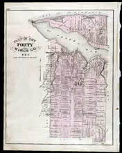
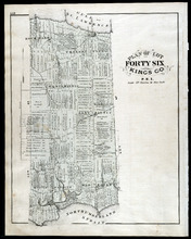
Plan of Lot Fourty: Kings Co., P.E.I.
Description: The map shows Lot 40 in Kings county. Shown are a bay, gulf, river, ponds, school house, churches, wharf, post office, roads, landowners and acreage, and mills. Compass.
Province: Prince Edward Island
Type: cadastral maps
Date Issued (Source): 1880
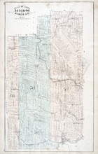
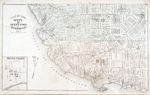
Plan of Lots 49 & 50: Queens Co., P.E.I.
Description: The map shows lot 49 & 50 in Queens County. Shown are roads, landowners and acreage, lakes, bays, coves, wharfs, post offices, churches, and schools. Graphic compass
Province: Prince Edward Island
Type: cadastral maps
Date Issued (Source): 1880
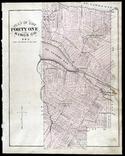
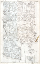
Plan of Lot Forty One: Kings Co., P.E.I.
Description: The map shows lot 41 in Kings county. Shown are St. Peters bay, river, gulf, roads, landowners and acreage, railroad and station, post offices, mills, schools, and churches. Compass.
Province: Prince Edward Island
Type: cadastral maps
Date Issued (Source): 1880
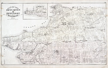
Plan of Lots 51, 52, & 66: Kings Co., P.E.I.
Description: The map shows lots 51, 52, & 66 in Kings county. Shown are roads, railroads and stations, landowners and acreage, streams, rivers, post offices, mills, and churches. Graphic compass.
Province: Prince Edward Island
Type: cadastral maps
Date Issued (Source): 1880
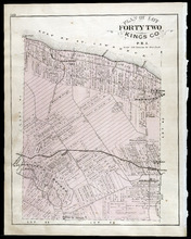
Plan of Lot Forty Two: Kings Co., P.E.I.
Description: The map shows lot 42 in Kings county. Shown are a gulf, marsh, roads, railroad and stations, post offices, school houses, rivers, and a brook. Compass.
Province: Prince Edward Island
Type: cadastral maps
Date Issued (Source): 1880
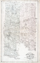
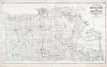
Plan of Lots Fifty Three & Fifty Four: Kings Co., P.E.I.
Description: The map shows lots 53 & 54 in Kings county. Shown are roads, railroads and stations, landowners and acreage, rivers, creeks, wharfs, post offices, and mills. Graphic compass.
Province: Prince Edward Island
Type: cadastral maps
Date Issued (Source): 1880
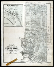
Plan of Lot Fourty Five: Kings Co., P.E.I.
Description: The map shows Lot 45 in Kings county. Shown are the gulf, bay, rivers, coves, post offices, cross, mills, roads, railroad, landowners and acreage, churches, hospital, harbour, and sand. Compass.
Province: Prince Edward Island
Type: cadastral maps
Date Issued (Source): 1880
Plan of Lots 55 & 56: Kings Co., P.E.I.
Description: The map shows lots 55 & 56 in Kings county. Shown are roads, landowners and acreage, crosses, rivers, ponds, creeks, bays, coves, sand, wharfs, mills, post offices, churches, schools, and… more
Province: Prince Edward Island
Type: cadastral maps
Date Issued (Source): 1880
Plan of Lot Fourty Six: Kings Co., P.E.I.
Description: The map shows lot 46 in Kings county. Shown are a gulf, straits, pond, roads, landowners and acreage, school houses, post offices, mills, and sand. Compass.
Province: Prince Edward Island
Type: cadastral maps
Date Issued (Source): 1880
Plan of Lots Fifty Seven & Fifty Eight: Queens Co., P.E.I.
Description: The map shows lots 57 & 58 in Queens county. Includes an inset map of Prim Island / Point Prim. Shown are roads, landowners and acreage, crosses, rivers, ponds, creeks, bays, coves, sand, wharfs… more
Province: Prince Edward Island
Type: cadastral maps
Date Issued (Source): 1880
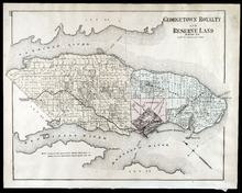
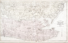
Georgetown Royalty and Reserve Land: Kings Co., P.E.I.
Description: The map shows Georgetown Royalty and Reserve Land in Kings county. Shown are rivers, roads, railroads and stations, landowners and acreage, beaches, Georgetown commons, square, market, court house,… more
Province: Prince Edward Island
Type: cadastral maps
Date Issued (Source): 1880
Plan of Lots 59 & 61: Kings Co., P.E.I.
Description: The map shows lots 59 & 61 in Kings county. Shown are roads, landowners and acreage, crosses, rivers, ponds, creeks, bays, coves, sand, wharfs, mills, post offices, churches, schools, light… more
Province: Prince Edward Island
Type: cadastral maps
Date Issued (Source): 1880
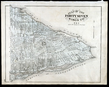
Plan of Lot Forty Seven: Kings Co., P.E.I.
Description: The map shows Lot 47 in Kings county. Shown are a gulf, straits, rivers, lakes, swamp, sand, fishing huts, mills, post offices, churches, creeks, light house, and pond. Compass.
Province: Prince Edward Island
Type: cadastral maps
Date Issued (Source): 1880
Plan of Lot Sixty & Sixty Two: Queens Co., P.E.I.
Description: The map shows lots 60 & 62 in Queens county. Shown are roads, landowners and acreage, rivers, straits, ponds, bays, creeks, sand, post offices, mills, churches, and school houses. Graphic compass.
Province: Prince Edward Island
Type: cadastral maps
Date Issued (Source): 1880
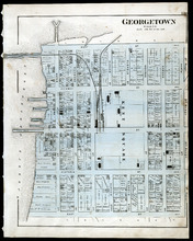
Georgetown: Kings Co., P.E.I.
Description: The map shows Georgetown in Kings county. Shown are wharfs, harbour, roads and streets, railroads and stations, landowners, houses, court house, scholl house, drill shed, Georgetown square, churches… more
Province: Prince Edward Island
Type: cadastral maps
Date Issued (Source): 1880
Plan of Lots 63 & 64: Kings Co., P.E.I.
Description: The map shows Lots 63 & 64 in Kings county. Shown are roads, landowners and acreage, crosses, rivers, straits, ponds, gulfs, marshes, coves, wharfs, post offices, mills, churches, factories, and… more
Province: Prince Edward Island
Type: cadastral maps
Date Issued (Source): 1880
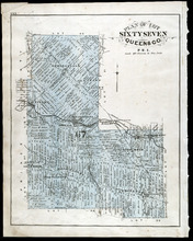
Plan of Lot Sixty Seven: Queens Co., P.E.I.
Description: The map shows Lot 67 in Queens county. Shown are roads, landowners and acreage, railroads and stations, post offices, church, and school houses. Compass.
Province: Prince Edward Island
Type: cadastral maps
Date Issued (Source): 1880
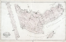
Plan of Lot 65 : Queens Co., P.E.I.
Description: The map shows Lot 65 in Queens county. Shown are roads, landowners and acreage, creeks, rivers, straits, marshes, brooks, coves, sand, reef, fishing stage, wharfs, post offices, mills, churches,… more
Province: Prince Edward Island
Type: cadastral maps
Date Issued (Source): 1880
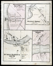
Port Selkirk Farm or Brush Wharf, Stanley Bridge: Murray Harbour South, and Vernon River Bridge
Description: The map shows Port Selkirk Farm or Brush Wharf lot 57 in Queens county. Shown are a river, wharf, road and street, landowners, and measurements. Compass.
Province: Prince Edward Island
Type: cadastral maps
Date Issued (Source): 1880
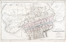
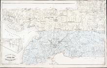
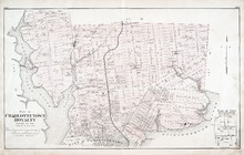
Map of the City of Charlottetown
Description: The map shows the city of Charlottetown. Shown are the wards, roads, landowners and acreage, asylums, ponds, rivers, houses, cemetery, estates, churches, lakes, parks, wharfs, and Charlottetown… more
Province: Prince Edward Island
Type: cadastral maps
Date Issued (Source): 1880
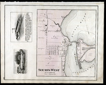
Souris West Lot 44: Kings Co., P.E.I.
Description: The map shows Lot 44 in Souris West, Kings county. Shown are a bay, harbour, river, railroad, landowners, roads, houses and buildings, school houses, businesses, and shipyards. Compass.
Province: Prince Edward Island
Type: cadastral maps
Date Issued: 1880
Date Issued (Source): 1880
Plan of Charlottetown Royalty: Queens Co., P.E.I.
Description: The map shows the city of Charlottetown and a plan for lots. Shown are rivers, creeks, roads, railroad and stations, landowners and acreage, mills, park, bridge, college, farms, asylums, and a… more
Province: Prince Edward Island
Type: cadastral maps
Date Issued (Source): 1880
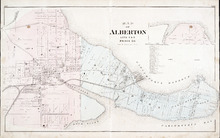
Map of Alberton Lots 4 & 5: Prince Co., P.E.I.
Description: The map shows lots 4 & 5 in the town of Alberton, Prince county. Shown are rivers, creeks, lakes, wharfs, shipyard, roads, railroad, landowners and acreage, mills, churches and cemetery. Compass… more
Province: Prince Edward Island
Type: cadastral maps
Date Issued (Source): 1880
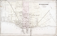
Summerside: Prince Co.
Description: The map shows the city of Summerside. Shown are the wards, roads, landowners and acreage, harbour, barracks, schools, squares, shipyards, railroad and station, and wharfs. Compass.
Province: Prince Edward Island
Type: cadastral maps
Date Issued (Source): 1880
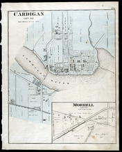
Cardigan Lot 53: Morrell Lot 40
Description: The map shows lot 53 in Cardigan. Shown are a river, roads, railroads, lots, landowners, school house, buildings, houses, wharfs and creeks. Compass.
Province: Prince Edward Island
Type: cadastral maps
Date Issued (Source): 1880

Montague Bridge Lots 59 & 52: Kings Co., P.E.I.
Description: The map shows lots 59 & 52 in Montague Bridge, Kings county. Shown are rivers, wharfs, shipyards, roads, landowners and acreage, halls, churches, buildings and businesses. Compass.
Province: Prince Edward Island
Type: cadastral maps
Date Issued (Source): 1880
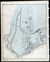
Souris
Description: The map shows a part of Souris. Shown are the Souris river, sand beach, roads, railroads, churhces, landowners, houses, buildings and businesses. Compass
Province: Prince Edward Island
Type: cadastral maps
Date Issued (Source): 1880