| Title Proper |
Illustrated historical atlas of the province of Prince Edward Island
|
|---|---|
| Subtitle |
From surveys made under the direction of C. R. Allen
|
| Description |
Published in 1880 by the J. H. Meacham Company, the Illustrated Historical Atlas of the Province of Prince Edward Island contains maps of each Lot on the Island, maps of Charlottetown and various towns and villages, and engravings of prominent citizens, properties and businesses. The maps are based on surveys made under the direction of C. R. Allen, C.E.
Included in this atlas is a Historical Sketch of the Province of Prince Edward Island and a Patron's Directory. The Historical Sketch covers the history of the Island from the first settlements and treaties to governance and Confederation. The Patron's Directory, located at the back of the atlas, gives biographical information about principal businessmen and professionals across the Island. This directory includes information such as their profession, nativity, and date of settlement. |
| Access Condition |
This material is provided for research, education, and private use only.
|
| Type | |
| Physical Location |
Robertson Library, UPEI
|
| Contributors |
Creator: Allen, C. R.
|
| Date Issued |
1880
|
| Publisher |
J. H. Meacham & company
|
| Extent |
12, 15-162 p. : ill.
|
| Subject (Geographic) | |
| Subject (Topical) |
Illustrated historical atlas of the province of Prince Edward Island: From surveys made under the direction of C. R. Allen
In this collection
Displaying 109 - 135 of 147
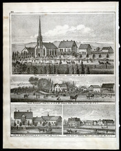
Property Sketches - Page 38
Description: Sketches of locations in Charlottetown and Little York (Lot 34) on Prince Edward Island. Sketches include the residences and property of Hon. W. W. Sullivan, Richard Vessey, Fredk. Hardy, and E. W.… more
Province: Prince Edward Island
Type: image
Date of Part: 1880
Date Issued (Source): 1880
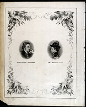
Dedication Page
Description: This page appears after the Table of Contents and contains portraits of the Governor General Marquis of Lorne and Her Royal Highness Princess Louise.
Province: Prince Edward Island
Type: image
Date Issued (Source): 1880
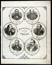
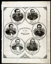
Portraits of Representatives of the Press - Page 22
Description: Sketch of Representatives of the Press including W. L. Cotton (Examiner), Henry Lawson (Patriot), P. R. Bowers (New Era), John Caven (Charlottetown Herald), Rev. Stephen G. Lawson (Presbyterian), and… more
Province: Prince Edward Island
Type: image
Date Issued (Source): 1880
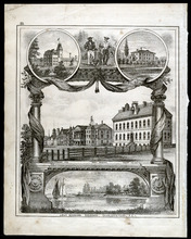
Property Sketches - Page 25
Description: Sketch of various major properties and buildings in Charlottetown, Prince Edward Island including Prince of Wales College, the New Aslyum (Falconwood), Market P.O., Province House, the Court House,… more
Province: Prince Edward Island
Type: image
Date Issued (Source): 1880
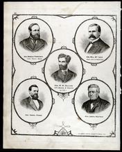
Portraits of Representatives of the Press - Page 26
Description: Sketch of Representatives of the Press including A. L. Graves (Summerside Journal), W. A. Brennan (Summerside Journal), Thomas P. Gorman (Summerside Progress), Peter McCourt (Kings County Advertiser… more
Province: Prince Edward Island
Type: image
Date Issued (Source): 1880
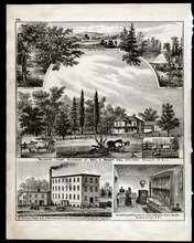
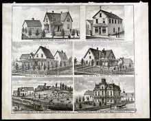
Property Sketches - Page 29
Description: Sketches of locations in and around Charlotteown, Prince Edward Island. Sketches include the residences and property of Benj. E. Wright Esq. (Belmont Farm), McKinnon, Fraser
Province: Prince Edward Island
Type: image
Date Issued (Source): 1880
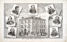
Property Sketches - Page 35
Description: A two page sketch of the Bank of Prince Edward Island in Charlottetown, P.E.I. surrounded by portraits of the Board of Directors (Hon. W. W. Lord, James Peake Esq., Hon. Joseph Hensley, Richard J.… more
Province: Prince Edward Island
Type: image
Date of Part: 1880
Date Issued (Source): 1880
Portraits of Honorable Residents of P.E.I.- Page 41
Description: Sketched portraits of Hon. Donald Ferguson (Com. Public Works), Hon. Neil McLeod (Prov. Secretary and Treasurer), Hon. W. W. Sullivan (Attorney General
Province: Prince Edward Island
Type: image
Date of Part: 1880
Date Issued (Source): 1880
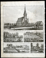
Property Sketches - Page 46
Description: Sketches of the residences and property of Justice Young, L. L. D. (Fairholm, Charlottetown) and Henry Longworth Esq. (Glynwood, Charlottetown) on Prince Edward Island.
Province: Prince Edward Island
Type: image
Date of Part: 1880
Date Issued (Source): 1880
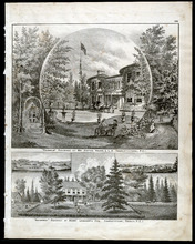
Property Sketches - Page 49
Description: Sketches of the residences and property of Arthur W. Holroyd Esq. (Wyhther Grange, Charlottetown) and James Dixon Esq. (Lot 33) in Prince Edward Island.
Province: Prince Edward Island
Type: image
Date of Part: 1880
Date Issued (Source): 1880
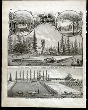
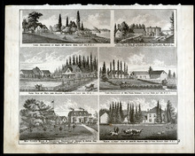
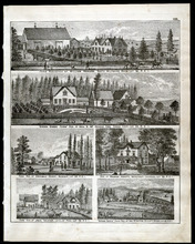
Property Sketches - Page 54
Description: Sketches of the residences and property of George Mutch Esq. (Brantford Farm, French Fort, Lot 35) and Abraham Gill Esq. (Little York, Lot 34) in Prince Edward Island.
Province: Prince Edward Island
Type: image
Date of Part: 1880
Date Issued (Source): 1880
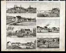
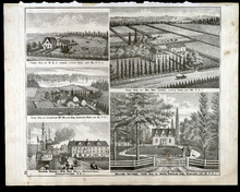
Property Sketches - Page 57
Description: Sketches of various locations across Prince Edward Island including Pownal (Lot 49), Park Corner (Lot 21), West River (Lot 32), Long Creek (Lot 65), Clifton (Lot 21), Clyde River (Lot 31, and Lot 48… more
Province: Prince Edward Island
Type: image
Date of Part: 1880
Date Issued (Source): 1880
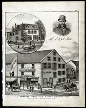
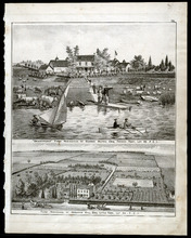
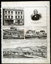
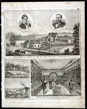
Property Sketches - Page 62
Description: Sketches of C. E. Robertson's business, (Custom Tailor more
Province: Prince Edward Island
Type: image
Date of Part: 1880
Date Issued (Source): 1880
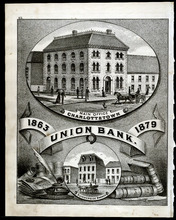
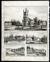
Property Sketches - Page 65
Description: A large sketch of Union Bank (1863-1879) in both Charlottetown (Main Office) and Summerside, Prince Edward Island.
Province: Prince Edward Island
Type: image
Date of Part: 1880
Date Issued (Source): 1880
Property Sketches - Page 70
Description: Sketches of various locations across Prince Edward Island including Stanhope (Lot 34), Covehead (Lot 34), Marshfield (Lot 34), and Charlottetown. Sketches include the residences and property of Angus… more
Province: Prince Edward Island
Type: image
Date Issued (Source): 1880
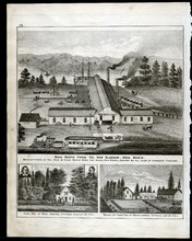
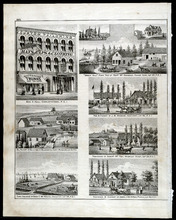
Property Sketches - Page 73
Description: Large sketch of Nova Scotia Forge Co. in New Glasgow, Nova Scotia as well as sketches of the residences and property of Benj. Hughes, Covehead (Lot 34) and David Lawson (Mount Joy Farm), Covehead (… more
Province: Prince Edward Island
Type: image
Date of Part: 1880
Date Issued (Source): 1880
Property Sketches - Page 78
Description: Sketches of various locations across Prince Edward Island including Brackley Point (Lot 33), Covehead (Lot 34), Little York, and Charlottetown (Royalty West). Sketches include the residences and… more
Province: Prince Edward Island
Type: image
Date of Part: 1880
Date Issued (Source): 1880
Property Sketches - Page 81
Description: Sketches of various locations across Prince Edward Island including Little York (Lot 34), Covehead West (Lot 33), Stanhope (Lot 34), and Charlottetown. Sketches include the residences and property of… more
Province: Prince Edward Island
Type: image
Date of Part: 1880
Date Issued (Source): 1880
Property Sketches - Page 86
Description: Sketches of various locations across Prince Edward Island including Wheatley River (Lot 24), Greenvale (Lot 23), New Glasgow (Lot 23), and Charlottetown. Sketches include the residences and property… more
Province: Prince Edward Island
Type: image
Date of Part: 1880
Date Issued (Source): 1880
Property Sketches - Page 89
Description: Sketches of various locations across Prince Edward Island including Rustico (Lot 24), French River (Lot 21), Hope River (Lot 22), and New London (Lot 21). Sketches include the residences and property… more
Province: Prince Edward Island
Type: image
Date of Part: 1880
Date Issued (Source): 1880
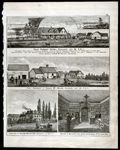
Property Sketches - Page 94
Description: Sketches of various locations across Prince Edward Island including Wheatley River (Lot 24), French River (Lot 21), Seal River (Lot 50), and Charlottetown. Sketches include the residences and… more
Province: Prince Edward Island
Type: image
Date of Part: 1880
Date Issued (Source): 1880
Property Sketches - Page 97
Description: Sketches of various locations across Prince Edward Island including Hope River (Lot 22), South Rustico (Lot 24), North River (Lot 32), Stanhope (Lot 34) and Hampton (Lot 29). Sketches include the… more
Province: Prince Edward Island
Type: image
Date of Part: 1880
Date Issued (Source): 1880

Property Sketches - Page 102
Description: Sketches of various locations across Prince Edward Island including Hope River (Lot 22), New London (Lot 21), Vernon River (Lot 49), and Charlottetown. Sketches include the residences and property of… more
Province: Prince Edward Island
Type: image
Date of Part: 1880
Date Issued (Source): 1880
Property Sketches - Page 105
Province: Prince Edward Island
Type: image
Date of Part: 1880
Date Issued (Source): 1880
Property Sketches - Page 110
Description: Sketches of various locations across Prince Edward Island including South Wiltshire (Lot 32), Canoe Cove (Lot 65), Bedeque (Lot 26), Crapaud (Lot 29), Loyalist Road (Lot 32), and Elliott River (Lot… more
Province: Prince Edward Island
Type: image
Date of Part: 1880
Date Issued (Source): 1880
Property Sketches - Page 113
Description: Sketches of various locations across Prince Edward Island including Kelly's Cross (Lot 29), North Bedeque (Lot 25), Crapaud (Lot 29), and Lake Verde (Lot 49). Sketches include the residences and… more
Province: Prince Edward Island
Type: image
Date of Part: 1880
Date Issued (Source): 1880
Property Sketches - Page 118
Description: Sketches of various locations across Prince Edward Island including properties in Summerside and on Loyalist Road (Lot 32). Sketches include the residences and property of A. L. Graves, S. A. Muncey… more
Province: Prince Edward Island
Type: image
Date of Part: 1880
Date Issued (Source): 1880