| Title Proper |
Illustrated historical atlas of the province of Prince Edward Island
|
|---|---|
| Subtitle |
From surveys made under the direction of C. R. Allen
|
| Description |
Published in 1880 by the J. H. Meacham Company, the Illustrated Historical Atlas of the Province of Prince Edward Island contains maps of each Lot on the Island, maps of Charlottetown and various towns and villages, and engravings of prominent citizens, properties and businesses. The maps are based on surveys made under the direction of C. R. Allen, C.E.
Included in this atlas is a Historical Sketch of the Province of Prince Edward Island and a Patron's Directory. The Historical Sketch covers the history of the Island from the first settlements and treaties to governance and Confederation. The Patron's Directory, located at the back of the atlas, gives biographical information about principal businessmen and professionals across the Island. This directory includes information such as their profession, nativity, and date of settlement. |
| Access Condition |
This material is provided for research, education, and private use only.
|
| Type | |
| Physical Location |
Robertson Library, UPEI
|
| Contributors |
Creator: Allen, C. R.
|
| Date Issued |
1880
|
| Publisher |
J. H. Meacham & company
|
| Extent |
12, 15-162 p. : ill.
|
| Subject (Geographic) | |
| Subject (Topical) |
Illustrated historical atlas of the province of Prince Edward Island: From surveys made under the direction of C. R. Allen
In this collection
Displaying 28 - 54 of 147

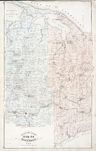
Plan of Lot Fourteen & Sixteen : Prince Co., P.E.I.
Description: Map shows lots fourteen & sixteen in Prince county. Shown are roads, creeks, coves, rivers, post offices, railroads and stations, ferries, points, bays, landowners, acreage, churches, and… more
Province: Prince Edward Island
Type: cadastral maps
Date Issued (Source): 1880

Plan of Lot Ten: Prince Co., P.E.I.
Description: The map shows lot 10 in Prince county. Shown are roads, rivers and creeks, railroad and station, post offices, a school, and landowners and acreage. Compass.
Province: Prince Edward Island
Type: cadastral maps
Date Issued (Source): 1880

Plan of Lot Seventeen: Prince Co., P.E.I.
Description: The map shows lot 17 along with two smaller maps of lot 17 and 23. The map includes landowners and acreage, railroads and stations, roads, districts, creeks, rivers, bays, marshes, brooks, coves,… more
Province: Prince Edward Island
Type: cadastral maps
Date Issued (Source): 1880
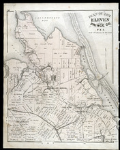
Plan of Lot Eleven: Prince Co., P.E.I.
Description: The map shows lot 11 in Prince county. Shown are roads, landowners and acreage, rivers, bays, coves, creeks, ponds, sand, railroad and station, post offices, and school houses. Compass.
Province: Prince Edward Island
Type: cadastral maps
Date Issued (Source): 1880

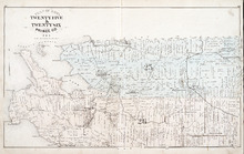
Plan of Lot Twenty One & Twenty: Queens Co., P.E.I.
Description: The map shows lots 21 and 20 (coloured in pink) in Queens county that border Prince county. The map names roads, landowners and acreage, creeks, gulfs, rivers, coves, fishing stations, post offices,… more
Province: Prince Edward Island
Type: cadastral maps
Date Issued (Source): 1880

Victoria, Lot 29; Map of Lennox Island
Description: The page displays map of Victoria in Lot 29. Shown are roads and streets, a harbour, wharfs, landowners, post offices, buildings and school houses. Compass. The page also displays a map of Lennox… more
Province: Prince Edward Island
Type: cadastral maps
Date Issued (Source): 1880
Plan of Lots 22 & 23 : Queens Co., P.E.I.
Description: The map shows lots 22 and 23 in Queens county. The map names roads, landowners and acreage, churches, halls, post offices, railroads, rivers, bays, and guls. Graphic compass.
Province: Prince Edward Island
Type: cadastral maps
Date Issued (Source): 1880
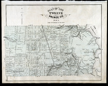
Plan of Lot Twelve: Prince Co., P.E.I.
Description: The map shows lot 12 in Prince county. Shown are the Narrows, roads, railroad and station, ponds, landowners and acreage, school houses, creeks, rivers, and coves.
Province: Prince Edward Island
Type: cadastral maps
Date Issued (Source): 1880
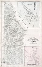
Plan of Lot Twenty Four: Queens Co., P.E.I.
Description: The map shows lot 24 in Queens county. Shown are rivers, gulfs, capes harbours, wharfs, lighthouses, fishing stages and holes, seaside hotels and bath houses, churches, crosses, post offices, roads,… more
Province: Prince Edward Island
Type: cadastral maps
Date Issued (Source): 1880
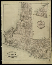
Plan of Lot Fifteen: Prince Co., P.E.I.
Description: The map shown is lot 15 in Prince county. Shown are byas, wharfs, landonwers and acreage, roads, post offices, villages, rivers, coves, a commissioners line, fishing coves, a court house, and stores… more
Province: Prince Edward Island
Type: cadastral maps
Date Issued (Source): 1880
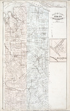
Plan of Lots Twenty Five & Twenty Six: Prince Co., P.E.I.
Description: The map shows lots 25 and 26 in Prince county. The map names roads, landowners and acreage, railroads, post offices, churches, harbours, lighthouses, hotels, coves. and rivers. Graphic compass.
Province: Prince Edward Island
Type: cadastral maps
Date Issued (Source): 1880
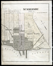
Summerside: Prince Co., P.E.I.
Description: The map shows the city of Summerside. Shown are the wards, a corportion line, landowners and acreage, roads, cemetery, buildings, railroad wharfs, and a harbour.
Province: Prince Edward Island
Type: cadastral maps
Date Issued (Source): 1880

Plan of Lot Twenty Seven: Prince Co., P.E.I.
Description: The map shows lot 27 in Prince county. The map shows roads, railroads, crosses, ponds, rivers, bays, straits, coves, mills, post offices, and churhces. Graphic compass.
Province: Prince Edward Island
Type: cadastral maps
Date Issued (Source): 1880
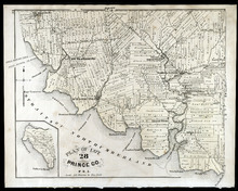
Plan of Lot 28: Prince Co., P.E.I.
Description: The map shows lot 28 in Prince county. Shown are straits, coves, rivers, Anglo-American cable, Winter Crossing Ice Boats, post offices, churches, landowners and acreage, and factories. Compass.
Province: Prince Edward Island
Type: cadastral maps
Date Issued (Source): 1880
Plan of Lots Twenty Nine & Thirty: Queens Co., P.E.I.
Description: The map shows lots 29 (coloured in blue) and 30 (coloured in pink) in Queens county. The map shows straits, rivers, post offices, roads, landowners and acreage, and churches. Graphic compass.
Province: Prince Edward Island
Type: cadastral maps
Date Issued (Source): 1880
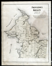
Princetown Royalty: Prince Co., P.E.I.
Description: The map shows Princetown Royalty, in Prince county. Shown are Bays, a basin, rivers, commons, sand, points, wharfs, churches, cemetery, post offices, roads, and landowners.
Province: Prince Edward Island
Type: cadastral maps
Date Issued (Source): 1880
Plan of Lot Thirty One: Queens Co., P.E.I.
Description: The map shows lot 31 in Queens county. Shown are rivers, landowners and acreage, post offices, creeks, railroads and stations, roads, churches, a ferry, and school houses. Compass. Illustrated… more
Province: Prince Edward Island
Type: cadastral maps
Date Issued (Source): 1880
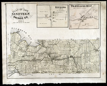
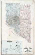
Plan of Lot Nineteen: Prince Co., P.E.I.
Description: The map shows lot 19 in Prince county. Shown are creeks, bays, roads, railroads and stations, landowners and acerage, post offices and buildings. Compass.
Province: Prince Edward Island
Type: cadastral maps
Date Issued (Source): 1880
Plan of Lots 33 & 34: Queens Co., P.E.I.
Description: The map shows lots 33 (coloured in blue) & 34 (coloured in pink) in Queens county. The map shows roads, railroads and stations, landowners and acreage, farms, post offices, churches, hotels,… more
Province: Prince Edward Island
Type: cadastral maps
Date Issued (Source): 1880
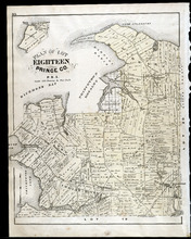
Plan of Lot Eighteen: Prince Co., P.E.I.
Description: The map shows lot 18 in Prince county. Shown are bays, capes, points, coves, post offices, schools, creeks, mills, churches, landowners and acreage, and roads. Compass.
Province: Prince Edward Island
Type: cadastral maps
Date Issued (Source): 1880
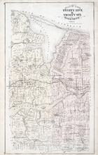
Plan of Lot Thirty Five & Thirty Six: Queens Co., P.E.I.
Description: The map shows lots 35 & 36 in Queens county. Shown are gulfs, bays, sand, coves, wharfs, rivers, ponds, creeks, fishing houses, roads, landowners and acreage, post offices, school houses,… more
Province: Prince Edward Island
Type: cadastral maps
Date Issued (Source): 1880
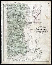
Plan of Lot Thirty Two: Queens Co., P.E.I.
Description: The map shows lot 32 in Queens county. Shown are roads, landowners and acreage, railroad and station, post offices, rivers, churches, and coves. Compass.
Province: Prince Edward Island
Type: cadastral maps
Date Issued (Source): 1880

Plan of Lot Thirty Seven : Plan of Lot Thirty Eight: Queens Co., P.E.I.. Kings Co., P.E.I.
Description: The map shows lot 37 (coloured in pink) in Queens county, and lot 38 (coloured in blue) in Kings county. Shown are roads, railroads, landowners and acreage, rivers, ponds, harbours, gulfs, creeks,… more
Province: Prince Edward Island
Type: cadastral maps
Date Issued (Source): 1880
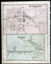
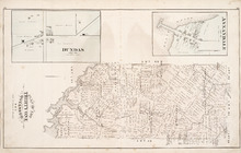
Kensington, Lot 19: St. Peters, Lot 41
Description: The map shows lot 19 in Kensington. Shown are a school house, a hall, roads, landowners, railroad and depot grounds, businesses and churches. Compass.
Province: Prince Edward Island
Type: cadastral maps
Date Issued (Source): 1880
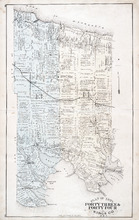
Plan of Lots Fourty Three & Fourty Four: Kings Co., P.E.I.
Description: The map shows lots 43 & 44 in Kings county. Shown are bays, gulfs, rivers, coves, capes, roads, railroads and stations, landowners and acreage, crosses, post offices, churches, and factories.… more
Province: Prince Edward Island
Type: cadastral maps
Date Issued (Source): 1880
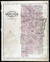
Plan of Lot Thirty Nine: Kings Co., P.E.I.
Description: The map shows lot 39 in Kings county. Shown are a gulf, lake, sand, light house, post offices, landowners and acreage, roads, railroads and stations, rivers, school houses, churches, and an Indian… more
Province: Prince Edward Island
Type: cadastral maps
Date Issued (Source): 1880
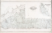
Plan of Lot Fourty Eight: Queens Co., P.E.I.
Description: The map showing lots 48 in Queens county. Shown are the commissioners line, rivers, coves, marsh, creeks, ponds, lakes, roads, landowners and acreage, asylum, hospital, and post offices. Graphic… more
Province: Prince Edward Island
Type: cadastral maps
Date Issued (Source): 1880