Displaying 163 - 216 of 220
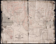
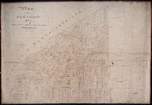
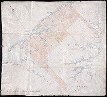
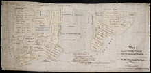
Plan of Lot 28: Prince Co. P.E.I.
Description: Printed map of Lot 28. Names and land conveyance references have been added in red ink. The map shows residents, lots, roads, bodies of water such as rivers, towns, and cities, buildings, and an… more
Province: Prince Edward Island
Type: cadastral maps

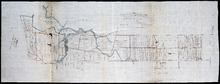
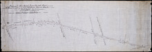
Plan of New Line Road from South Wiltshire Road Lot 31 to Emyvale Road Lot 65
Description: Plan of new line of road from South Wiltshire Road, Lot 31, to Emyvale Road, Lot 65. The map shows lots, roads, and residents.
Province: Prince Edward Island
Type: cadastral maps
Date Created: 1892-12-29
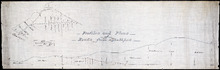
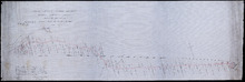
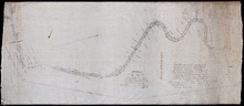
Profiles and plans of roads from Southport
Description: Profiles and plans of roads from Southport. (No.10) The map shows roads, lots, residents, and acreage.
Province: Prince Edward Island
Type: cadastral maps
Plan of proposed road from Winsloe Road to Brackley Point Road touching at Roy; Junc; Station
Description: Plan of proposed road from Winsloe Road to Brackley Point Road touching at Royalty Junction Station. Lot 33. (No.28) The map shows lots, roads, and residents.
Province: Prince Edward Island
Type: cadastral maps
Plan from French Village Road to Anderson Road
Description: Plan of road from French Village Road to Anderson Road. Lot 37. (No.8; also No.1 Queen's Co.) The map shows lots, roads, residents, and foliage. more
Province: Prince Edward Island
Type: cadastral maps
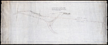
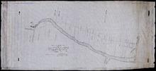
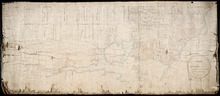
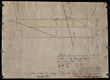
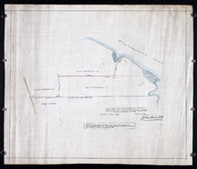
Section Shewing the Elevations of the Prince Toen Road from Hunter River to the Junction Road.
Description: Plan showing the elevations of the Prince Town Road from Hunter River to the Junction Road.
Province: Prince Edward Island
Type: cadastral maps
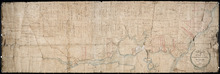
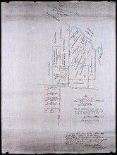
Plan Shewing the Malpeque Road from Charlottetown Royalty to Murrays: also the intended new line of…
Description: Plan Showing the Malpeque Road from Charlottetown Royalty to Murrays, also the intended new line of Road to avoid the Hills as Shown by the dotted line. Also are roads, lots, and bodies of water.
Province: Prince Edward Island
Type: cadastral maps

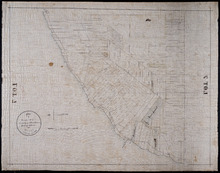
Plan of Town Lots No.74 and No.75 in the 4th Hundred of Town Lots in the city of Charlottetown with…
Description: Plan of Town Lots No.74 and No.75 in the 4th Hundred of Town Lots in the city of Charlottetown with the respective subdivisions delineated thereon. (No.64) Shown are lots and residents.
Province: Prince Edward Island
Type: cadastral maps
Plan of New Line Road From Montague Bridge tp Keith's Mill on Lots No. 51 & 52: Kings…
Description: Plan of a new line of road from Montague Bridge to Keith's Mill on Lots 51 and 52. As ordered by Jas. E. McDonald, late C.P.W. The map shows lots, residents, roads, and bodies of water such as… more
Province: Prince Edward Island
Type: cadastral maps

P.E.I. Railway Murray Harbour Branch: Plan of Spur Line and Ballast Pit at Surrey
Description: Prince Edward Island Railway. Murray Harbour Branch. Plan of Spur Line and Ballast Pit at Surrey (No.1159). Plan produced by H. Laurence, Engineer in Charge. Shown are roads, the railway, lots, and… more
Province: Prince Edward Island
Type: cadastral maps
Date Created: 1908-12-02
Plan of Township No. 7 the property of R.Bruce Stewart: Drawn by R. Stewart 1861 from survey by A.…
Description: Plan of Lot 7. The property of R. Bruce Stewart (No.23). Surveyed by A. Anderson and others, and drawn by R. Stewart. The map shows lots, residents, and roads.
Province: Prince Edward Island
Type: cadastral maps
Date Created: 1861
Plan of Township No. 7: Copied from the the Survey of John Clan L.S>
Description: Plan of Lot 7 (No.22). Stewart Estate. Shows names of residents, acreage, and references to land conveyance, roads, and bodies of water. Plan copied by Owen Curtis.
Province: Prince Edward Island
Type: cadastral maps
Tracing of Plan of the North Moiety of Township No. 26: The property of the Messrs Thompson of…
Description: Tracing of Plan of the North Moiety of Lot 26, the property of the Messrs. Thompson of Belfast, Ireland. Documents attached. The map shows lots, residents, roads, acreage, and bodies of water.
Province: Prince Edward Island
Type: cadastral maps
Date Created: 1875-11-05
Proposed New Road from Chapel Road: To Road leading to Grand River Beach Road
Description: Plan of proposed New Road from Chapel Road to road leading to Grand River Beach Road. Total distance 2.16 miles. (No.47) The map shows residents, lots, roads, and foliage.
Province: Prince Edward Island
Type: cadastral maps

Plan of Part of Railway Line on Lot No. 16
Description: Plan of part of the Railway Line on Lot 16. The map shows roads, lots, water, and residents.
Province: Prince Edward Island
Type: cadastral maps
Date Created: 1872-04-30

Prince Edward Island Railway Plan showing right of way of the Murray Harbour Branch through Queen…
Description: Prince Edward Island Railway Plan showing right of way of the Murray Harbour Branch through Queen's County from Village Green to Pisquid Road. (Plan No.6) The map shows lots, residents, railway… more
Province: Prince Edward Island
Type: cadastral maps
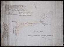
Prince Edward Island Railway
Description: Prince Edward Island Railway. Land appropriated at Souris. This plan shewing the lands appropriated by the Railway Commissioners is filed in the Office of Registar of Deeds and Keeper of Plans for… more
Province: Prince Edward Island
Type: cadastral maps
Date Created: 1874
Prince Edward Island Railway Murray Harbour Branch: Plan of extension from Murray River to Murray…
Description: Prince Edward Island Railway. Murray Harbour Branch. Plan of extension from Murray River to Murray Harbour. Produced by Wm. B. MacKenzie, Chief Engineer. The map shows lots, residents, acreage and… more
Province: Prince Edward Island
Type: cadastral maps
Date Created: 1906-05-31
Plan of Lot 2
Description: The map shows Lot 2 divided into parcels of land. It provides the names of residents, their acreage amounts and some land conveyance references for most of the east end of the lot and for a small… more
Province: Prince Edward Island
Type: cadastral maps
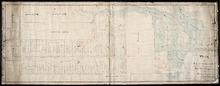
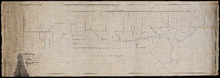
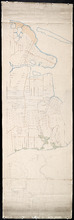
Plan of Lots 38, 39, 40, 41, 42, 66 and part of Lot 43
Description: The map shows some of the lots and parishes in a northern portion of Kings County. It shows Savage Harbour, St. Peter's Bay, rivers, streams, mills, roads, buildings and churches. The map has a… more
Province: Prince Edward Island
Type: topographic maps

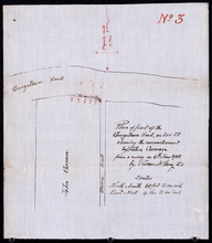
Tracing of the right of way for the Prince Edward Island Railway into Georgetown.
Description: Tracing of the right of way for the Prince Edward Island Railway into Georgetown.
Province: Prince Edward Island
Type: cadastral maps
This Plan shewing the lands appropriated by the Railway Commisioners is filed with the Office of…
Description: Prince Edward Island Railway. Plan shows land appropriated by the Railway Commissioners on Lot 45. (No.235C). The map shows residents, acreage, roads, and a church.
Province: Prince Edward Island
Type: cadastral maps

Plan of Part of the Railway Line on Lots No. 16 and 17
Description: Plan of part of the Railway Line on Lots 16 and 17. Appropriations from Lot 16 to the French purchase. The map shows roads, lots, residents, and acreage.
Province: Prince Edward Island
Type: cadastral maps
Date Created: 1872-04-29

Plan of Part of the Railway Line on Lot No. 17: Shewing the Stations Grounds at Summerside.
Description: Plan of part of the Railway Line on Lot 17 showing the Station Grounds at Summerside (No.2). Former location of the appropriations from Linkletter Road into Summerside. The map shows roads, lots,… more
Province: Prince Edward Island
Type: cadastral maps
Date Created: 1872-04-29
Paln No. 1 of Railway Appropriation: from Alberton to Tignish
Description: Plan of Railway Appropriations from Alberton to Tignish. (Plan No.1). The map shows roads, resdients, acreage, lots, and foliage.
Province: Prince Edward Island
Type: cadastral maps
Date Created: 1873
Plan No. 2 of Railway Appopriation: From Alberton to Tignish
Description: Plan of Railway Appropriations from Alberton to Tignish. (Plan No.2). The map shows roads, lots, residents, acreage, and foliage.
Province: Prince Edward Island
Type: cadastral maps
Date Created: 1873

Plan of part of the Railway appropriations in Lot 45: Harmony Station
Description: Plan of part of the Railway appropriations in Lot 45. Harmony Station. The map shows roads, residents and acreage.
Province: Prince Edward Island
Type: cadastral maps

A Plan of the undisposed of Part, of Lot No. 38 in Queens County in Prince Edward Island
Description: A plan of the undisposed part of Lot 58 (No.154). Shows residents, lots, roads, and water. Surveyed by Rod'k Campbell. more
Province: Prince Edward Island
Type: cadastral maps
Date Created: 1860
Plan of Lot or Township No 59: Two Thirds being the property of The Messrs Montgimeries being 13,…
Description: Plan of Lot 59 (No.157). Two thirds being the property of the Messrs. Montgomeries being 13,064 acres. One third, the property of Earl Selkirk. Plan copied by Jas. J. Bevan. Date of plan: April 1848… more
Province: Prince Edward Island
Type: cadastral maps
Lot 50
Description: Plan of Lot 63 (No.2). The property of J. Cambridge. Mainly outline. Shows a few residents, lots, bodies of water, islands, and roads.
Province: Prince Edward Island
Type: cadastral maps
Date Created: 1829-04
Plan of Township No 63, St. Andrews Parish Kings County: Prince Edward Island
Description: Plan of Lot 63. Eastern part shows names of residents, lots, acreage, bodies of water such as rivers, and bays, and roads.
Province: Prince Edward Island
Type: cadastral maps
Date Created: 1842
Plan of Township No 63 St. Andrew's Parish Queens County: P.E.Island
Description: Plan of Lot 63. This is one of the plans referred to in the Deed from the Cunards to the Commissioner of Public Lands, July 15, 1866. The map shows lots, residents, roads, acreage and bodies of water… more
Province: Prince Edward Island
Type: cadastral maps
Date Created: 1851
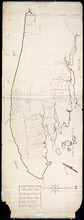
A Plan of Lot No 64: The property of J. Cambridge Esq Situate in Kings County P.E.Island
Description: Plan of Lot 64. The property of J. Cambridge. Shows some residents. Copy by James Richard. The map shows lots, residents, roads, cities, towns, and bodies of water.
Province: Prince Edward Island
Type: cadastral maps
Date Created: 1829-03
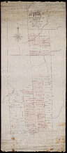
Plan of Lot or Township No. 66 from actual survey.
Description: Plan of Lot or Township No. 66 from actual survey. Rolled paper on fabric backing; handwriting on verso. The map shows Lot 66 divided into parcels of land with the names of residents and their… more
Province: Prince Edward Island
Type: cadastral maps
Plan of the Moiety of Lot or Township No 29 of the Estate of Viscount elville situated in Prince…
Description: Plan of the east moiety of Lot 29 (No.2). Part of the estate of Lord Viscount Melville. The map shows lots, residents, roads, and bodies of water such as rivers.
Province: Prince Edward Island
Type: cadastral maps
Plan Showing the situation of the Estate of Mr. Clement White on Lot or Township No. 32
Description: Plan of part of Lot 32 (No.21). The estate of Mr. Clement White. The map shows lots, residents, roads, and York (or North) River.
Province: Prince Edward Island
Type: cadastral maps
Date Created: 1874-01
Plan of the Property of Mrs Smith situate in Township No 33 in Prince Edward Island: Mrs S's…
Description: Plan of part of Lot 33 showing the property of Mrs. S.W. Smith. The map shows lots, residents, acreage, roads, and water.
Province: Prince Edward Island
Type: cadastral maps
Plan of the Property of Ms S W Smith Situate on Township No 33 in Prince Edward Island: Mrs S'…
Description: Plan of part of Lot 33, showing the property of Mrs. S.W. Smith. The map shows lots, residents, roads, and bodies of water such as rivers.
Province: Prince Edward Island
Type: cadastral maps
Plan of Lot 35
Description: Plan of Lot 35 (No.95). Shows some residents, lots, roads, bodies of water and foliage.
Province: Prince Edward Island
Type: cadastral maps
Plan of part of Township Number 35 situate on the North side of the Hillsborough River.: Those…
Description: Plan of Lot 35 (No.1). North side of the Hillsborough River. Property of Rev. John MacDonald. From a tracing by W.C. Harris. The map shows lots, residents, roads, and bodies of water.
Province: Prince Edward Island
Type: cadastral maps
Date Created: 1878-03-21
Plan of Part of Township no 35 on Bedford Bay
Description: Plan of part of Lot 35 (No.631) bordering on Bedford Bay. The map shows lots, residents, roads, and various bodies of water.
Province: Prince Edward Island
Type: cadastral maps
Plan of Part of Township No. 35 on the North Side of the Hillsborough River
Description: Plan of part of Lot 35 on the north side of the Hillsborough River. The map shows lots, residents, roads, Bedford Bay and foliage.
Province: Prince Edward Island
Type: cadastral maps
Plan of Lot 37
Description: Plan of Lot 37, north of the Hillsborough River. Shows some residents, lots, roads, and bodies of water.
Province: Prince Edward Island
Type: cadastral maps
Plan of the estates of the late Angus McDonald and James McDonald at Springfield Township No 39:…
Description: Part of Lot 39. Plan of the estates of the late Angus McDonald and James McDonald at Springfield. Also the subdivisions of the same as agreed upon at the time of survey. The map shows lots, residents… more
Province: Prince Edward Island
Type: cadastral maps
Date Created: 1910-09
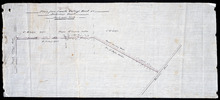
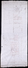
Plan of the division line between Lots 31 and 65, the commencement of which was set by the…
Description: Plan of the division line between Lots 31 and 65, the commencement of which was set by the Commissioners for establishing boundary lines. (No.1) The map shows lots, roads, and rivers.
Province: Prince Edward Island
Type: cadastral maps
Date Created: 1837-08-26
Royalty of Charlotettown
Description: Plan showing the line dividing Lots 33 and 34. (No.10). The map shows lots, residents, roads, and bodies of water.
Province: Prince Edward Island
Type: cadastral maps
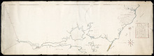
Plan of a New Road from the Flat River Road (marked A, B, C, D, E, F.) to the shore of the straits…
Description: Plan of a New Road from the Flat River Road to the shore of the straits. On Lots 60 and 62. The map shows lots, residents, roads, and water.
Province: Prince Edward Island
Type: cadastral maps
Plan shewing the situation of a new line of road from Baldwin's Road, Lot 51 to Brother's…
Description: Plan showing the situation of a new line of road from Baldwin's Road, Lot 51 to Brother's Road, Lot 66 more
Province: Prince Edward Island
Type: cadastral maps
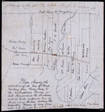
Plan shewing the situation of the line of road leading from Cherry Valley to the contemplated…
Description: Plan showing the situation of the line of road leading from Cherry Valley to the contemplated bridge on Seal River and the 24 chains and 50 links unopened line of road along the line between the… more
Province: Prince Edward Island
Type: cadastral maps
Plan of part of the Georgetown Road on Lot 51 showing the encrouchment by John Curran from a survey…
Description: Plan of part of the Georgetown Road on Lot 51. Shows Union Road and property of John Curran. (No.3) The map shows lots, resident, and roads.
Province: Prince Edward Island
Type: cadastral maps
Date Created: 1908-06-04
Plan of the road from Kelly's Cove to the line between John F. Baker and Frank Bovyer thro…
Description: Plan of the road from Kelly's Cove to the line between John F. Baker and Frank Bovyer through Bunbury, Lot 48. Ordered to be widened. The map shows lots, residents, roads, and water. more
Province: Prince Edward Island
Type: cadastral maps
Plan of proposed new road straightening Rollo Bay Road, through the farms of Chas. Townshend and…
Description: Plan of proposed new road straightening Rollo Bay Road, through the farms of Chas. Townshend and Jos. Webster. The map shows lots, residents, and roads.
Province: Prince Edward Island
Type: cadastral maps
Proposed New Road from Rustico Road to Brookfield Road
Description: Proposed New Road from Rustico Road to Brookfield Road. The map shows lots, roads, residents, and a swamp.
Province: Prince Edward Island
Type: cadastral maps
Plan showing the position of 2 new lines of road from R. McMillan's Mills to Fredericton…
Description: Plan showing the position of 2 new lines of road from R. McMillan's Mills to Fredericton Station. Also through McMillan's land from French Settlement. Also from Trout River Bridge to Road… more
Province: Prince Edward Island
Type: cadastral maps