Displaying 55 - 81 of 81
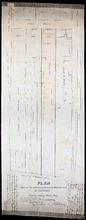
Plan Shewing the situation of that part of Water Lot No. 7. at Charlottetown Sold to Henry Beer Esq.
Description: Plan showing the situation of that part of Water Lot No.7 at Charlottetown sold to Henry Beer. (No.26) (Also No.216 Queens County). The map shows streets such as Great George, Prince, Water, wharfs,… more
Province: Prince Edward Island
Type: cadastral maps
Date Created: 1881
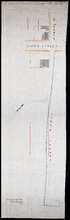
Plan Shewing the situation of Water Lot No. 8, and that part of Water Lot No. 7 conveyed to Ronald…
Description: Plan showing the situation of Water Lot No.8 and that part of Water Lot No.7 conveyed to Ronald MacMillan. The map also shows streets such as Water street, Prince, lots, Ferry Wharf, and Hillsborough… more
Province: Prince Edward Island
Type: cadastral maps
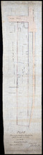
Plan of part of Charlottetown showing Pownal Wharf and Lot No.5
Description: Plan of part of Charlottetown showing Pownal Wharf and part of Town Lot No.5 located in 1st Hund. Also shown are buildings and wharfs.
Province: Prince Edward Island
Date Created: 1868-08

Alberton, Prince Edward Island: Population 1500. Hand Engine. 400' Hose. Water Supply: Brook…
Description: This is a fire insurance plan of the town of Alberton concentrating on two blocks of Main Street from Church Street to Argyle Street. A key plan in the lower left corner provides context. The map was… more
Publisher: Chas. E. Goad, Civil Engineer
Province: Prince Edward Island
Type: fire insurance maps
Date Created: 1888-10
Date Modified: 1910-10
Date Issued (Source): 1888
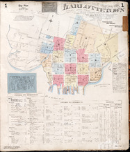
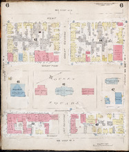
Charlottetown Prince Edward Island: Population: 12,500. July 1903
Description: This item, the first of 20 pages of fire insurance maps of Charlottetown, serves as the key plan for the other Charlottetown pages. It was created in 1903, revised to 1910 and revised again to 1917.… more
Publisher: Chas. E. Goad, Civil Engineer
Province: Prince Edward Island
Type: fire insurance maps
Date Created: 1903-07
Date Modified: 1910-08, 1917-07
Date Issued (Source): 1888
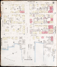
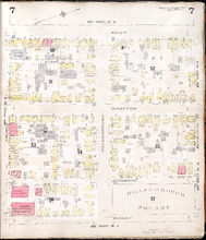
Charlottetown, Prince Edward Island: July 1917. Reprinted
Description: This is Page 2 of 20 pages of fire insurance maps of Charlottetown. It shows the area from Sidney Street to the waterfront, between Haviland and Queen streets. The map shows numbered city blocks and… more
Publisher: Chas. E. Goad, Civil Engineer
Province: Prince Edward Island
Type: fire insurance maps
Date Created: 1917-07
Date Issued (Source): 1888
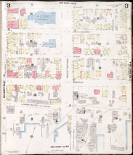
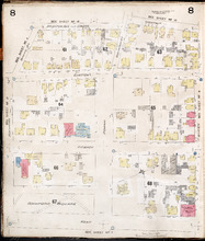
Charlottetown, Prince Edward Island: July 1917. Reprinted
Description: This is Page 3 of 20 pages of fire insurance maps of Charlottetown. It shows the area from Sidney Street to the waterfront, between Queen and Prince streets. The map shows numbered city blocks and… more
Publisher: Chas. E. Goad, Civil Engineer
Province: Prince Edward Island
Type: fire insurance maps
Date Created: 1917-07
Date Issued (Source): 1888
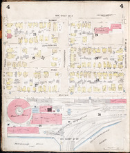
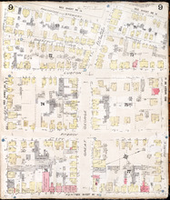
Charlottetown, P.E.I.: July 1903
Description: This is Page 4 of 20 pages of fire insurance maps of Charlottetown. It was created in 1903 and revised to either 1910 or 1917. The map shows the area from Sidney Street to the waterfront, between… more
Publisher: Chas. E. Goad, Civil Engineer
Province: Prince Edward Island
Type: fire insurance maps
Date Created: 1903-07
Date Modified: 1910-08, 1917-07 (year and month uncertain)
Date Issued (Source): 1888
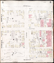
Charlottetown, P.E.I.: July 1917. Reprinted
Description: This is Page 5 of 20 pages of fire insurance maps of Charlottetown. It shows the area from Kent Street to Sidney Street, between Rochford and Queen streets. The map shows numbered city blocks and the… more
Publisher: Chas. E. Goad, Civil Engineer
Province: Prince Edward Island
Type: fire insurance maps
Date Created: 1917-07
Date Issued (Source): 1888
Charlottetown, P.E.I.: July 1903.
Description: This is Page 6 of 20 pages of fire insurance maps of Charlottetown. It was created in 1903 and revised to either 1910 or 1917. The map shows the area from Kent Street to Sidney Street, between Queen… more
Publisher: Chas. E. Goad, Civil Engineer
Province: Prince Edward Island
Type: fire insurance maps
Date Created: 1903-07
Date Modified: 1910-08, 1917-07 (year and month uncertain)
Date Issued (Source): 1888
Charlottetown, P.E.I.: July 1903.
Description: This is Page 7 of 20 pages of fire insurance maps of Charlottetown. It was created in 1903 and revised to either 1910 or 1917. The map shows the area from Kent Street to Sidney Street, between Prince… more
Publisher: Chas. E. Goad, Civil Engineer
Province: Prince Edward Island
Type: fire insurance maps
Date Created: 1903-07
Date Modified: 1910-08, 1917-07 (year and month uncertain)
Date Issued (Source): 1888
Charlottetown, P.E.I.: July 1903
Description: This is Page 8 of 20 pages of fire insurance maps of Charlottetown. It was created in 1903 and revised to either 1910 or 1917. It shows the area from Churchill Avenue and Chestnut Street to Kent… more
Publisher: Chas. E. Goad, Civil Engineer
Province: Prince Edward Island
Type: fire insurance maps
Date Created: 1903-07
Date Modified: 1910-08, 1917-07 (year and month uncertain)
Date Issued (Source): 1888
Charlottetown, P.E.I.: July 1903.
Description: This is Page 9 of 20 pages of fire insurance maps of Charlottetown. It was created in 1903 and revised to either 1910 or 1917. It shows the area from Passmore Street to Kent Street, between Queen and… more
Publisher: Chas. E. Goad, Civil Engineer
Province: Prince Edward Island
Type: fire insurance maps
Date Created: 1903-07
Date Modified: 1910-08, 1917-07 (year and month uncertain)
Date Issued (Source): 1888
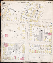
Charlottetown P.E.I.: July 1903
Description: This is Page 10 of 20 pages of fire insurance maps of Charlottetown. It was created in 1903 and revised to either 1910 or 1917. It shows the area from just north of Euston Street, south to Kent… more
Publisher: Chas. E. Goad, Civil Engineer
Province: Prince Edward Island
Type: fire insurance maps
Date Created: 1903-07
Date Modified: 1910-08, 1917-07 (year and month uncertain)
Date Issued (Source): 1888
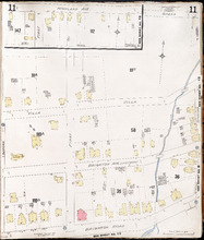
Charlottetown P.E.I.: July 1917. Reprinted
Description: This item, Page 11 of 20 pages of fire insurance plans of Charlottetown, consists of two (2) maps. The main map shows the area from Green Street to Brighton Road, between Greenfield Avenue (Second)… more
Publisher: Chas. E. Goad, Civil Engineer
Province: Prince Edward Island
Type: fire insurance maps
Date Created: 1917-07
Date Issued (Source): 1888
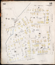
Charlottetown P.E.I.: July, 1903.
Description: This is Page 12 of 20 pages of fire insurance maps of Charlottetown. It was created in 1903 and revised to either 1910 or 1917. It shows the area from Douglas Street to Churchill Avenue and Chestnut… more
Publisher: Chas. E. Goad, Civil Engineer
Province: Prince Edward Island
Type: fire insurance maps
Date Created: 1903-07
Date Modified: 1910-08, 1917-07 (year and month uncertain)
Date Issued (Source): 1888
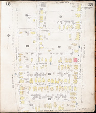
Charlottetown P.E.I.: July, 1903.
Description: This is Page 13 of 20 pages of fire insurance maps of Charlottetown. It was created in 1903 and revised to either 1910 or 1917. It shows the area bounded by Connolly Street in the north, Elm Avenue/… more
Publisher: Chas. E. Goad, Civil Engineer
Province: Prince Edward Island
Type: fire insurance maps
Date Created: 1903-07
Date Modified: 1910-08, 1917-07 (year and month uncertain)
Date Issued (Source): 1888
Charlottetown P.E.I.: July, 1903.
Description: This is Page 14 of 20 pages of fire insurance maps of Charlottetown. It was created in 1903 and revised to either 1910 or 1917. It shows the area from Allan (Allen) Street, in the north, to (… more
Publisher: Chas. E. Goad, Civil Engineer
Province: Prince Edward Island
Type: fire insurance maps
Date Created: 1903-07
Date Modified: 1910-08, 1917-07 (year and month uncertain)
Date Issued (Source): 1888
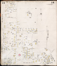
Charlottetown, P.E.I.: July, 1903.
Description: This is Page 15 of 20 pages of fire insurance maps of Charlottetown. It was created in 1903 and revised to either 1910 or 1917. The map shows part of the eastern portion of early twentieth-century… more
Publisher: Chas. E. Goad, Civil Engineer
Province: Prince Edward Island
Type: fire insurance maps
Date Created: 1903-07
Date Modified: 1910-08, 1917-07 (year and month uncertain)
Date Issued (Source): 1888
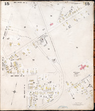
Charlottetown P.E.I.: July 1903
Description: This is Page 16 of 20 pages of fire insurance maps of Charlottetown. It was created in 1903 and revised to either 1910 or 1917. It contains two (2) maps, showing two (2) different areas of the city.… more
Publisher: Chas. E. Goad, Civil Engineer
Province: Prince Edward Island
Type: fire insurance maps
Date Created: 1903-07
Date Modified: 1910-08, 1917-07 (year and month uncertain)
Date Issued (Source): 1888

Plan of Alberton: Surveyed by John Ball, Land Surveyor
Description: Plan of part of Alberton, Lot 4. Shows names of residents and land conveyance references, bodies of water such as bays, and creeks, and roads.
Province: Prince Edward Island
Type: cadastral maps
Date Created: 1871-08
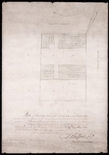
Plan of part of Town Lots Nos. 54 and 55, and Nos. 91 and 92 in the 2nd Hundred of Town Lots in…
Description: Plan of part of Town Lots Nos. 54 and 55, and Nos. 91 and 92 in the 2nd Hundred of Town Lots in Charlottetown agreeably to the possession of the Misses Stewart according to the original survey of the… more
Province: Prince Edward Island
Type: cadastral maps
Date Created: 1860-07-25

A Plan of Land on Lot or Township No. 17 in Prince County, P. E. Island
Description: A plan of part of Lot 17, the property of J. Weatherbe, Summerside. (No.11). Shown are lots, residents, measurements and roads.
Province: Prince Edward Island
Type: cadastral maps
Date Created: 1857-06

Plan of A Tract of Land situate in Summerside P.E.Island, in the possesion of Mr. Jesse Green, laid…
Description: Plan of a tract of land situated in Summerside and laid off in pasture lots. The property of Mr. Jesse Green. The map shows lots, residents, roads, and acreage.
Province: Prince Edward Island
Type: cadastral maps
Date Created: 1877-04-24

Plan of Town Lots No.74 and No.75 in the 4th Hundred of Town Lots in the city of Charlottetown with…
Description: Plan of Town Lots No.74 and No.75 in the 4th Hundred of Town Lots in the city of Charlottetown with the respective subdivisions delineated thereon. (No.64) Shown are lots and residents.
Province: Prince Edward Island
Type: cadastral maps
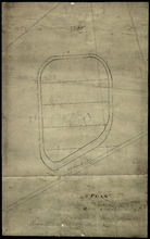
Plan of Race Course Charlottetown Royalty
Description: Plan of the Old Race Course in Charlottetown Royalty. (No.21). Shows lots and residents.
Province: Prince Edward Island
Type: cadastral maps

Plan of Part of the Railway Line on Lot No. 17: Shewing the Stations Grounds at Summerside.
Description: Plan of part of the Railway Line on Lot 17 showing the Station Grounds at Summerside (No.2). Former location of the appropriations from Linkletter Road into Summerside. The map shows roads, lots,… more
Province: Prince Edward Island
Type: cadastral maps
Date Created: 1872-04-29