Displaying 433 - 459 of 559
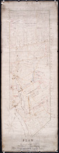
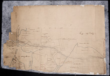
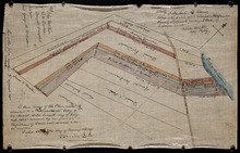
Plan of the Western Moriety of Township No. 29: The Estate of The honorable Lady Fane
Description: Plan of the western moiety of Lot 29 (No.78). The estate of the Hon. Lady Fane. Shows names of residents, acreage, and a few land conveyance references, bodies of water such as the Gulf of St.… more
Province: Prince Edward Island
Type: cadastral maps
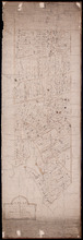
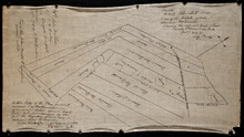
A Plan of the Western Moriety of Township Number 29: The property of Colonel The Hon. H.S. Fane…
Description: Plan of the western moiety of Lot 29 (No.81). Property of Colonel the Hon. H.S. Fane. Shows names of residents, acreage, and roads. Signed by Owen Curtis, Land Surveyor.
Province: Prince Edward Island
Type: cadastral maps
Copy of Plan of part of Lot 27 Prince County P.E.I. Purchased from Hon. J. C. Pope
Description: Copy of plan of part of Lot 27 purchased from Hon. J.C. Pope. The plan is referred to in the Deed from James Colledge Pope and his wife to the Commissioner of Public Lands, July 13, 1868. The map… more
Province: Prince Edward Island
Type: cadastral maps
Date Created: 1868
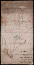
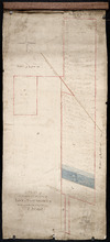
Plan of Part Township No. 28: The property of Henry Palmer Esquire
Description: Plan of part of Lot 28 (No.75). The property of Henry Palmer. Shows names of residents, acreage , and land conveyance references, bodies of water such as marshes, straits, and rivers, roads,… more
Province: Prince Edward Island
Type: cadastral maps

Map of Prince Edward Island in the Gulf of St. Lawrence: for McGregor's British America
Publisher: Ballantyne and Company
Province: Prince Edward Island
Type: cadastral maps, topographic maps
Date Created: 1832
Plan of part of the Railway appropriations in Lot 45: Harmony Station
Description: Plan of part of the Railway appropriations in Lot 45. Harmony Station. The map shows roads, residents and acreage.
Province: Prince Edward Island
Type: cadastral maps
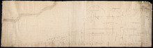
Plan of Lot No. 38 [? title partly missing]
Description: Plan of part of Lot 38 and part of Lot 39. Savage Harbour area. The map shows northern portions of Lot 38 and Lot 39 divided into parcels of land with names of residents and acreage amounts. It shows… more
Province: Prince Edward Island
Type: cadastral maps
Untitled
Description: Unfinished plan of Lot 45. The map shows some lots, residents, and bodies of water.
Province: Prince Edward Island
Type: cadastral maps
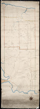
Lot No. 46
Description: Plan of Lot 46 (No.1) divided into two parts and drawn for in Council, Oct. 24, 1786. The map shows Lot 46 divided into two parts--Division No. 1 (west) and Division No. 2 (east)--of 10,000 acres… more
Province: Prince Edward Island
Type: cadastral maps
Date Created: 1786-10-24
Plan of the Northern Moiety of Lot 45: compiled from surveys made by L.N. Gall and H.J. Cundall.
Description: Plan of the northern moiety of Lot 45 compiled from surveys made by L.N. Gall and H.J. Cundall. Plan referred to in deed to Commissioner of Public Land, dated 13th July, 1866. The map of the northern… more
Province: Prince Edward Island
Type: cadastral maps
Date Created: 1866
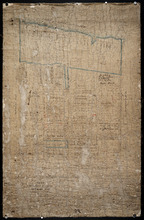
Plan of part of Lot 47: The Estate of the late Alexander McDonald showing allotments pursuant to…
Description: Plan of part of Lot 47. The estate of the late Alexander McDonald showing allotments pursuant to Order of Supreme Court Schedule G. The map shows the estate of the late Alexander McDonald divided… more
Province: Prince Edward Island
Type: cadastral maps
Date Created: 1885-07-07
Plan of part of Lot 47: The estate of the late Alexander McDonald showing the different kinds of…
Description: Plan of part of Lot 47. The estate of the late Alexander McDonald showing the different kinds of land. Schedule F. The map, drawn in black ink, shows the estate of the late Alexander McDonald divided… more
Province: Prince Edward Island
Type: cadastral maps
Date Created: 1885-07-07
Plan of the Northern Moiety of Lot or Township No. 48 in Prince Edward Island, Copied from the Plan…
Description: Plan of the northern moiety of Lot 48 (No.129). Shows the property of Miss Frances Crooke, R.G. Cuninghame, Theo. Desbrisay, and the Misses Lawton. The map shows lots, residents, roads, and bodies of… more
Province: Prince Edward Island
Type: cadastral maps
Date Created: 1836

Plan of Township No. 50 The Estate of the Misses[?] Fanning, Prince Edward Island: From actual…
Description: Plan of Lot 50. Fanning Estate. The map shows lots, residents, bodies of water and roads.
Province: Prince Edward Island
Type: cadastral maps
A Plan of the Eastern or C Division of Lot or Township No. 51: St. Georges Parish, Kings Coutnry, P…
Description: Plan of the eastern division of Lot 51. Montgomery Estate. The map shows the C Division of Lot 51 divided into numbered parcels of land with the names of owners or occupants with their corresponding… more
Province: Prince Edward Island
Type: cadastral maps

Plan of Lot or Township No. 51 in Kings County Prince Edward Island: Surveyed by G. Wright Jr. in…
Description: Plan of Lot 51 (No.141). Shows residents, lots, bodies of water such as rivers, and roads.
Province: Prince Edward Island
Type: cadastral maps
Date Created: 1836
Plan of Lot 57
Description: Plan of Lot 57 (No.2) showing the lot divided into quarters. Also shows Refugee Share drawn for in Council, 12 February, 1784.
Province: Prince Edward Island
Type: cadastral maps
Date Created: 1784-02-12

A Plan of the undisposed of Parts of Lot No. 57: in Queens County in Prince Edward Island
Description: A plan of the undisposed of parts of Lot 57. Surveyed by Rod'k Campbell. The map shows parcels of land with names of owners or occupants and their corresponding acreage amounts handwritten in… more
Province: Prince Edward Island
Type: cadastral maps
Date Created: 1860
Province of Prince Edward Island, Canada: Cummins Map Co. Toronto
Description: The map shows all of Prince Edward Island and some of New Brunswick and Nova Scotia. Shown through a table of Counties are bays, roads, marshes, rapids, Indian Reserves, Lighthouses, depth of water,… more
Publisher: Cummins Map Co.
Province: Prince Edward Island
Type: cadastral maps
Date Issued (Source): 1927
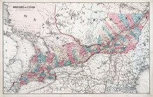
Dominion of Canada: (Western Sheet)
Description: Map showing the province of Ontario, and Quebec. Shows rivers, lakes, channels, bays, roads, railroads, cities, towns, copper mines, and sea measurements. Ontario and Quebec are coloured and cities… more
Publisher: J. H. Meacham & company
Province: Ontario, Quebec, Prince Edward Island, Michigan, New York, Ohio
Type: cadastral maps
Date Issued (Source): 1880
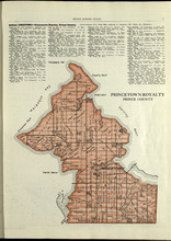
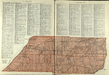
Princetown Royalty: Prince County
Description: The map shows Princetown Royalty in Prince County. Shown are rivers, bays, roads, landowners, acreage, and towns. Atlas of Province of Prince Edward Island, Canada and the World
Publisher: Cummins Map Co.
Province: Prince Edward Island
Type: cadastral maps
Date Issued (Source): 1927
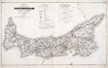
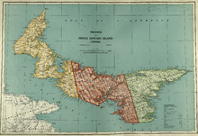
Map of the Province of Prince Edward Island: in the Gulf of St. Lawrence
Description: The map shows the province of Prince Edward Island. Shown are tables of Explanations and Electorial Districts, a compass and the county lines are marked in red. Shown are gulfs, straits, bays, reefs… more
Publisher: J. H. Meacham & company
Province: Prince Edward Island
Type: cadastral maps
Date Created: 1880
Date Issued (Source): 1880
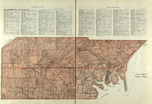
Lots 2 & 3 : Prince County
Description: The map shows lots 2 & 3 in Prince county. Shown are the Gulf of St. Lawrence, capes, ponds, landowners, acreage, rivers, and roads.
Publisher: Cummins Map Co.
Province: Prince Edward Island
Type: cadastral maps
Date Issued (Source): 1927
Lots 4 : Prince county
Description: The map shows Lots 4
Publisher: Cummins Map Co.
Province: Prince Edward Island
Type: cadastral maps
Date Issued (Source): 1927

Plan of Lot One: Prince Co., P.E.I.
Description: Map showing the northWestern tip of the island. It names the gulfs, rivers, ponds, landowners and acreage, roads, and railroads. A graphic compass.
Publisher: J. H. Meacham & company
Province: Prince Edward Island
Type: cadastral maps
Date Issued (Source): 1880
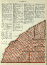
Lot No. 7: Prince County
Description: The map shows Lot 7 in Prince county. Shown are capes, coves, roads, landowners, and acreage.
Publisher: Cummins Map Co.
Province: Prince Edward Island
Type: cadastral maps
Date Issued (Source): 1927

Plan of Lot Six: Prince Co., P.E.I.
Description: Map showing lot six, bordering lots 5, 9, 10, 11 in Prince county. Shows rivers, creeks, railroads, roads, landowners, acreage, post offices, and buildings. Geographical compass
Publisher: J. H. Meacham & company
Province: Prince Edward Island
Type: cadastral maps
Date Issued (Source): 1880