Displaying 1 - 108 of 539
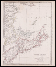
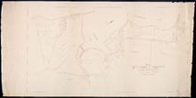
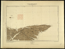
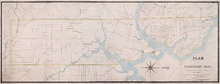
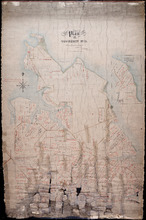
North America Sheet 1 : Nova Scotia with part of New Brunswick and Lower Canada
Description: North America, sheet 1, Nova Scotia with part of New Brunswick and Lower Canada. Published by Society for the Diffusion of Useful Knowledge. The map shows provinces, bodies of water, cities and towns… more
Province: Prince Edward Island, New Brunswick, Nova Scotia
Type: cadastral maps
Date Created: 1832-12-15

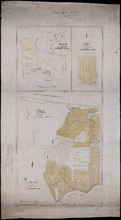
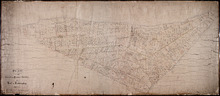
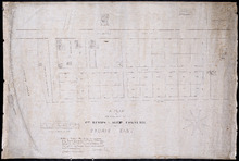
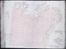
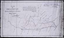
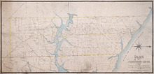
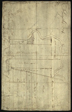
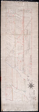
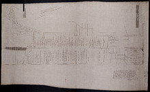
Plan of Lot or Township No 4, in P.E. Island: The shores and the division Lines coloured according…
Description: Plan of Lot 4. The shores and the division lines colored to yellow are according to actual survey. Shows names of some residents, acreage, roads, and bodies of water such as rivers.
Province: Prince Edward Island
Type: cadastral maps

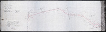
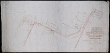
Plan of a Line of Road from Montague River Bridge to Wood Islands: Run in November 1833
Description: Plan of a line of road from Montague River Bridge to Wood Islands. Passes through Lots 59, 60, 61, and 62. (No.59). Shown are residents, lots, and rivers.
Province: Prince Edward Island
Type: cadastral maps
Date Created: 1833-11
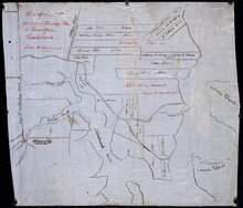
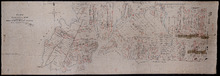
Unfinished plan of Alberton and Cascumpec Point, Lots 4 and 5
Description: Unfinished plan of Alberton and Cascumpec Point, Lots 4 and 5. Mainly outline. Shows churches, station ground, school, and the names of a few residents.
Province: Prince Edward Island
Type: cadastral maps

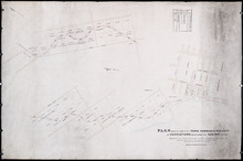
Plan of Lot No 1 Shewing the Extent of the Fishery Reserve to the Crown and situation of settlers…
Description: Plan of Lot 1 (No.6) showing the extent of the Fishery Reserve to the Crown and situation of settlers thereon. Also the site of the respective fishery establishments of the same, as delineated from… more
Province: Prince Edward Island
Type: cadastral maps
Date Created: 1853-10
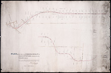
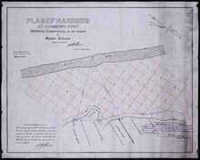
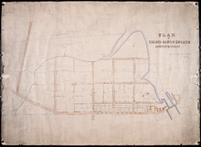
P.E.I. Railway Murray Harbour Branch : Plan Branch Line From Village Green to Vernon River Bridge
Description: Prince Edward Island Railway. Murray Harbour Branch. Plan of the branch line from Village Green to Vernon River Bridge (No.588). Plan produced by Wm. B. MacKenzie, Chief Engineer. The map shows lots… more
Province: Prince Edward Island
Type: cadastral maps
Date Created: 1906-05-28
Plan No 1 Office of the Registar of Deeds: Charlottetown P.E.Island
Description: Plan of land appropriated for the construction of the Murray Harbour Branch Railway through Queen's County (No.1). Plan produced by Wm. B. MacKenzie, Chief Engineer. The map shows residents,… more
Province: Prince Edward Island
Type: cadastral maps
Date Created: 1900-06-07
Plan of Cape Traverse Branch: Prince Edward Island Railway
Description: Canadian Government Railways, Prince Edward Island. Cape Traverse subdivision. Plans of the Railway right of way from Emerald Junction to Port Borden. Copied from the plans in the Engineer's… more
Province: Prince Edward Island
Type: cadastral maps
Plan of Railway appropriations in Lots 26, 27 and 28
Description: Plan of Railway appropriations in Lots 26, 27 and 28. The map shows lots, roads, residents, and acreage.
Province: Prince Edward Island
Type: cadastral maps, transportation maps
P.E.I. Railway: Elmira Branch Plan of Right-of-Way
Description: Prince Edward Island Railway. Elmira Branch. Plan of Right-of-Way (No.429, Kings Co.). Plan created by Wm. B. MacKenzie, Chief Engineer. The map shows lots, roads, residents, and acreage.
Province: Prince Edward Island
Type: cadastral maps
Date Created: 1909-06-02

Plan of Part of the Railway Line on Lots No 17.
Description: Plan of part of the Railway Line on Lot 17. Appropriations from the French Purchase to the Linkletter Road. The map shows roads, residents and acreage.
Province: Prince Edward Island
Type: cadastral maps, transportation maps
Date Created: 1872-04-29
Railway appropriations from Hunter River to Clyde Station: Lots 22 and 23
Description: Railway appropriations from Hunter River to Clyde Station. Lots 22 and 23. The map shows residents and acreage, roads, stations, ponds, and foliage.
Province: Prince Edward Island
Type: cadastral maps
Date Created: 1872
Plan-showing the Right of Way : Cape Traverse Branch P.E.I
Description: Plan showing the right of way of the Cape Traverse Branch of the Prince Edward Island Railway. The map shows roads, residents and acreage.
Province: Prince Edward Island
Type: cadastral maps

Plan Alterations of Railway on Lot 17 and Station Grounds at Summerside.
Description: Plan of Alterations of the Railway on Lot 17 and the Station Grounds at Summerside. The map shows lots, residents, streets, wharfs, and buildings.
Province: Prince Edward Island
Type: cadastral maps
Date Created: 1872-10-10
Plan of St. Martins, Township No. 35; Plan of 320 1/2 Acres of Land "Arisaig", Township…
Description: Plan of St. Martins, Lot 35 (south of the Hillsborough River). Also a plan of Arisaig, 320 and a half acres of land on Lot 35 and a plan of that part of Lot 36 north of the Hillsborough River.
Province: Prince Edward Island
Type: cadastral maps
Date Created: 1873
Map of Southport and Rosebank, Prince Edward Island: Drawn by C.D. Lambown Sept. 26, 1953
Description: Map of Southport and Rosebank, Lot.48. Shows names of residents, acreage, cities and towns, and Hillsborough River.
Province: Prince Edward Island
Type: cadastral maps
Date Created: 1953-09-26
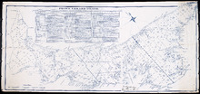
Map of Prince Edward Island showing Rural Catholic Religious Affiliation
Description: Map of Prince Edward Island showing Rural Catholic Religious Affiliation. Printed with color code shaded in with crayon. (Acc#2784/318) The map also shows bodies of water such as bays, and lots.
Province: Prince Edward Island
Type: cadastral maps, thematic maps
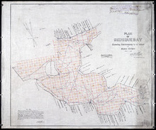
Plan of Richmond Bay from Grand River to Malpeque Harbour: showing location of Oyster Beds and…
Description: Plan of Richmond Bay from Grand River to Malpeque Harbour showing location of Oyster Beds and subdivisions for leasing purposes. (No.2) The map shows resdients, lots, measurements, islands, rivers,… more
Province: Prince Edward Island
Type: cadastral maps
Date Created: 1912-10-14
Plan of Richmond Bay from Grand River to Malpeque Harbour: Showing location of Oyster Beds and…
Description: Plan of Richmond Bay from Grand River to Malpeque Harbour showing location of Oyster Beds and subdivisions for leasing purposes. (No.2) The map shows residents, lots, measurements, islands, ponds and… more
Province: Prince Edward Island
Type: cadastral maps
Date Created: 1912-10-14

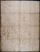
Topographical map of Prince Edward Island
Description: Topographical map of Prince Edward Island. Map has been cut into sections and pieced together. Therefore scale, date, etc. is missing. The maps shows mulitple bodies of water, counties, roads, towns… more
Province: Prince Edward Island
Type: cadastral maps

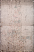
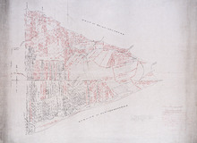
Plan of Township No. 67, and its environs.: Compiled from Surveys by Geo. Wright; H.J. Cundall;…
Description: Plan of Lot 67 and its environs. Compiled from surveys by Geo. Wright, H.J. Cundall, Joseph Ball, and Owen Curtis. Drawn by Thomas MacKinlay. Shows names of some residents, roads, railroads, bodies… more
Province: Prince Edward Island
Type: cadastral maps
Date Created: 1877-08-01
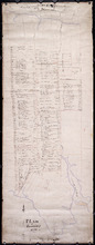
Stanhope Shore Rd.
Description: The map shows the Stanhope Shore Road with the names of residents, their road frontage measurements and dollar amounts for each.
Province: Prince Edward Island
Type: cadastral maps
Date Created: 1954

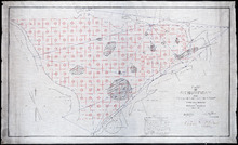
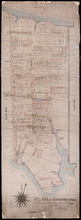
Provincal Electorial Map of Prince Edward Island
Description: The map shows Prince Edward Island divided into electoral districts, which are numbered by county.
Province: Prince Edward Island
Type: thematic maps

Education: Proposed Consolidation
Description: Map of Prince Edward Island. Education - proposed consolidation. Colored overlay on printed map. The map also shows the Gulf of St. Lawrence, Northumberland Strait, and various bodies of water.
Province: PE
Type: cadastral maps, thematic maps
Date Created: 1967-07

Map of Prince Edward Island
Description: Map of Prince Edward Island showing school districts(?). The map shows bodies of water and town and cities.
Province: Prince Edward Island
Type: cadastral maps, thematic maps
Date Created: 1971-02-05
Prince Edward Island
Description: Prince Edward Island. Geological Survey of Canada. The map shows the North Point of the island, roads, railways, post offices, towns, and cities.
Province: Prince Edward Island
Type: geological maps
Date Created: 1884
Prince Edward Island
Description: Prince Edward Island. Geological Survey of Canada. The map shows Prince county, roads, bodies of water, cities and towns.
Province: Prince Edward Island
Type: geological maps
Date Created: 1884
Plan of Webber Creek: being supplementary to "Plan of Richmond Bay from Curtain Island to…
Description: Plan of Webber Creek being supplementary to "Plan of Richmond Bay from Curtain Island to Lockes Shore" showing additional plots Nos. 478B, 478C, 478D, and 478E for Oyster Culture. The map… more
Province: Prince Edward Island
Type: plans
Date Created: 1913-10-08
Prince Edward Island
Description: Prince Edward Island. Geological Survey of Canada. The map shows Kings county roads, cities and towns.
Province: Prince Edward Island
Type: geological maps
Date Created: 1884
Plan of the Cunard and Palmer Estates in Lot or Township No.1.
Description: Plan of Lot 1 (No.1). Cunard and Palmer Estates. Drawn by Owen Curtis. Shows names of residents, acreage, and a few land conveyance references, and roads.
Province: Prince Edward Island
Type: cadastral maps
Plan of Township No 15: Taken from the survey of William Cutis (1826) wit alterations and…
Description: Plan of Lot 15 (No.42) taken from the survey of William Curtis (1826) with alterations and corrections from surveys made in 1849 and 1851 by Geo. Wright. Color code shows Crown Lands and lands… more
Province: Prince Edward Island
Type: cadastral maps
Date Created: 1851

Plan of Township No. 48: compiled during the year 1915 from plans on file in the Land Office and…
Description: Plan of Lot 48 compiled during the year 1915 from plans on file in the Land Office and Registry Office and from the chart of Charlottetown Harbour supplemented by the descriptions in the leases and… more
Province: Prince Edward Island
Type: cadastral maps
Date Created: 1915

Plan of Township No. 63: compiled from the proprietors' plans, descriptions in leases and…
Description: Plan of Lot 63 compiled from the proprietors' plans, descriptions in leases and registered deeds, and from Meacham's Atlas, with additions and corrections from surveys made at various times… more
Province: Prince Edward Island
Type: cadastral maps
Date Created: 1921-02
Plan of Cascumpec Point As sold by Public Auction in June 1871
Description: Plan of Cascumpec Point, as sold by public auction, June, 1871. The map shows lots, residents, bodies of water such as bays, cities and towns, and roads.
Province: Prince Edward Island
Type: cadastral maps
Date Created: 1871-08

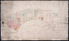
Plan of that portion of the town of Summerside laid off on the front of the farm by Mr. Jesse Green.
Description: Plan of that portion of the town of Summerside laid off on the front of the farm by Mr. Jesse Green. The map shows lots, residents, towns, cities, roads, and bodies of water.
Province: Prince Edward Island
Type: cadastral maps
Date Created: 1868-11-25
A Plan of the Property of Capt. Simon and Alexander Cheverie: in Souris East
Description: A plan of the property of Capt. Simon and Alexander Cheverie in Souris East. The map shows lots, acreage, roads/streets, and buildings.
Province: Prince Edward Island
Type: cadastral maps
Date Created: 1879-06-18

Common Lot No 21 as divided into Building Lots
Description: Plan of Common Lot No.21. Charlottetown as divided into building lots. (No.380) The map shows lots, acreage and roads/streets.
Province: Prince Edward Island
Type: cadastral maps
Date Created: 1872-08
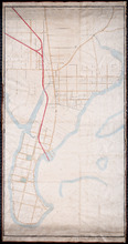
P.E.Island Railway: Charlottetown
Description: Prince Edward Island Railway. Charlottetown. Appropriations into Charlottetown Station. The map shows roads, streets, lots, and buildings.
Province: Prince Edward Island
Type: plans
Date Created: 1871

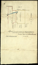
Plan of Lot 5
Description: Plan of Lot 5. Shows names of residents and acreage, rivers, creeks, roads, bays and Islands.
Province: Prince Edward Island
Type: cadastral maps

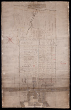
Plan of George Town: The Town Lots are 84 by 120 Feet. The North and South Streets are 100 Feet.…
Description: Plan of Georgetown showing lots and streets, bays, ranges, squares, and a school house. Also shows location of school house. Copy from the Office Plan No.6.
Province: Prince Edward Island
Date Created: 1853-06-07

A Plan of Township No 4 Part of the Cunard Estate Prince County P.E.Island
Description: A plan of Lot 4, part of the Cunard Estate. Copied from plans in the Public Lands Department. The map shows lots, residents, bodies of water such as rivers, railways, and roads.
Province: Prince Edward Island
Type: cadastral maps
Date Created: 1885-06
Part of Lot 12 : copied from Township Plan in Land Office Charlottetown
Description: Plan of part of Lot 12 - North Shore. Shows names of some residents, acreage, roads, creeks, Islands, towns and cities. Copied from Township Plan in the Land Office at Charlottetown.
Province: Prince Edward Island
Type: cadastral maps

Map of Prince Edward Island
Description: Map of Prince Edward Island. Shows roads, ponds, rivers, towns, cities, grist mills, saw mills, and churches.
Province: Prince Edward Island
Type: cadastral maps

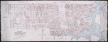
A plan of Charlottetown, the capital of the Island delineated by order of Walter Patterson,…
Description: A plan of Charlottetown, the capital of the Island delineated by order of Walter Patterson, Governor of the said Island (No.2). Includes Charlottetown Common and Royalty. Shows names of some… more
Province: Prince Edward Island
Type: cadastral maps

Plan of the Royalty of Charlottetown: from a survey taken in the year 1831 by Order of His…
Description: "Plan of the Royalty of Charlottetown from a survey taken in the year 1831 by Order of His Excellency Lieutenant Governor Ready." Shows Royalty Lot numbers, and acreage. (No.67) more
Province: Prince Edward Island
Type: cadastral maps
Date Created: 1831
Plan Shewing Lands in the Town, Common, and Royalty of Georgetown appropriated for Railway purposes…
Description: Plan showing lands in the Town, Common, and Royalty of Georgetown appropriated for Railway Purposes. The map shows residents, acreage, roads, and harbours.
Province: Prince Edward Island
Type: cadastral maps

Plan Shewing lands in Charlottetown Appropriated fro Railway purposes : The Figures 67 &c.…
Description: Plan showing lands in Charlottetown appropriated for Railway purposes. The map shows lots, residents, streets, and wharfs.
Province: Prince Edward Island
Type: cadastral maps
Plan Shewing Lands in the Common and Royalty of Charlottetown appropriated for Railway purposes.
Description: Plan showing land in the Common and Royalty of Charlottetown appropriated for Railway purposes. The map shows lots, acreage, roads, cities and towns.
Province: Prince Edward Island
Type: cadastral maps
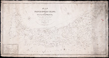
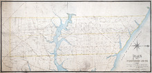
Map of Prince Edward Island, in the Gulf of St. Lawrence: Comprising the latest Topographical…
Description: Map of Prince Edward Island by George Wright, Surveyor General, 1852. Shows mail routes, roads, churches, water mills, population, boundaries, and post offices.
Province: Prince Edward Island
Type: cadastral maps
Date Created: 1852
A Plan of the Island St. John in the Gulf of St. Lawrence in the Province of Nova Scotia in North…
Description: Plan of the Island St. John in the Gulf of St. Lawrence in the Province of Nova Scotia in North America from a survey made by Samuel Holland in 1765. Shows statistical data and remarks regarding the… more
Province: Prince Edward Island
Type: cadastral maps
Date Created: 1765
Plan of Richmond Bay from Curtain Island to Malpeque Wharf: Showing location of Oyster Beds and…
Description: Plan of Richmond Bay from Curtain Island to Malpeque Wharf showing location of Oyster Beds and subdivision for leasing purposes. (No.3) The map shows residents, lots, measurements, and islands.
Province: Prince Edward Island
Type: cadastral maps
Date Created: 1912-10-14
Plan of Pownal Bay: showing the subdivisions to be leased for Oyster Culture
Description: Plan of Pownal Bay showing the subdivisions to be leased for Oyster Culture. (No.13) The map shows residents, lots, measurements, and islands.
Province: Prince Edward Island
Type: cadastral maps
Date Created: 1914

Plan of Richmond Bay from Curtain Island to Locke Shore : Showing location of Oyster Beds and…
Description: Plan of Richmond Bay from Curtain Island to Locke Shore showing location of Oyster Beds and subdivisions for leasing purposes. (No.1) The map shows residents, lots, measurements, islands, and rivers.
Province: Prince Edward Island
Type: cadastral maps
Date Created: 1912-10-14
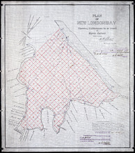
Plan of New London Bay: Showing Sub-divisions to be leased for Oyster Culture
Description: Plan of New London Bay showing sub-divisions to be leased for Oyster Culture. (No.9) The map shows residents, lots, measurements, and sand hills.
Province: Prince Edward Island
Type: cadastral maps
Date Created: 1914

Plan of Cascumpec Bay: Showing Sub-divisions to be leased for Oyster Culture
Description: Plan of Cascumpec Bay showing sub-divisions to be leased for Oyster Culture. (No.8) The map shows residents, measurements, lots, rivers, and sand hills.
Province: Prince Edward Island
Type: cadastral maps
Date Created: 1913-11-17

Plan of North River from Victoria Park to North River Bridge: Showing Subdivisions to be leased for…
Description: Plan of North River from Victoria Park to North River Bridge showing subdivisions to be leased for Oyster Culture. (No.5) The map shows residents, lots, measurements, and roads.
Province: Prince Edward Island
Type: cadastral maps
Date Created: 1913-02-15
Plan of Bedeque Bay : Showing Sub-divisions to be leased for Oyster Culture
Description: Plan of Bedeque Bay showing sub-divisions to be leased for Oyster Culture. (No.16) The map shows residents, lots, measurements, and Holman's Island. more
Province: Prince Edward Island
Type: cadastral maps
Date Created: 1914-06-01

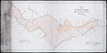
Plan of Barbara Weit River: Showing Subdivisions to be leased for Oyster Culture.
Description: Plan of Barbara Weit River showing subdivisions to be leased for Oyster Culture. (No.7) The map shows residents, lots, Richmond Bay and measurements.
Province: Prince Edward Island
Type: cadastral maps
Date Created: 1913-09-06
Plan of Foxley River: Showing Subdivisions to be leased for Oyster Culture
Description: Plan of Foxley River showing subdivisions to be leased for Oyster Culture. (No.17). The map shows residents, lots, and measurements.
Province: Prince Edward Island
Type: cadastral maps
Date Created: 1915

Plan of Dockriver: Showing Subdivisions to be leased for Oyster Culture.
Description: Plan of Dock River showing subdivisions to be leased for Oyster Culture. (No.14). The map shows residents, measurements, bays and Fox Island.
Province: Prince Edward Island
Type: cadastral maps
Date Created: 1913-11-17
Plan of Narrows at Cranberry Point: showing subdivisions to be leased for Oyster Culture
Description: Plan of Narrows at Cranberry Point (between Cascumpeque and Richmond Bays) showing subdivisions to be leased for Oyster Culture. (No.15). The map shows residents, measurements, sand hills, and a… more
Province: Prince Edward Island
Type: cadastral maps
Date Created: 1914-09-01
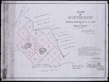
Plan of Oyster Cove: showing subdivisions to be leased for Oyster Culture
Description: Plan of Oyster Cove showing subdivisions to be leased for Oyster Culture. (No.6). The map shows redisents, measurements, and Richmond Bay.
Province: Prince Edward Island
Type: cadastral maps
Date Created: 1913-08-15
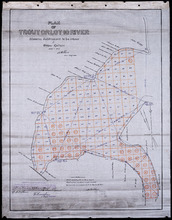
Plan of Trout or Lot 10 River: showing subdivisions to be leased for Oyster Culture
Description: Plan of Trout or Lot 10 River showing subdivisions to be leased for Oyster Culture. (No.18). The map shows redisents, measurements, and a certificate of registration.
Province: Prince Edward Island
Type: cadastral maps
Date Created: 1915
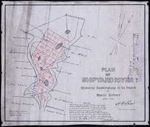
Plan of Shipyard River: showing subdivisions to be leased for Oyster Culture
Description: Plan of Shipyard River showing subdivisions to be leased for Oyster Culture. (No.11). The map shows lots, residents, and measurements, along with a certificate of registration.
Province: Prince Edward Island
Type: cadastral maps
Date Created: 1914
Plan of Indian River: showing subdivisions to be leased for Oyster Culture
Description: Plan of Indian River showing subdivisions to be leased for Oyster Culture. (No.12). The map shows lots, and residents namesm along with measurements of the lots to be leased. Also shown is a… more
Province: Prince Edward Island
Type: cadastral maps
Date Created: 1914
Plan of Bentinck Cove: Showing location of Oyster Beds and subdivisions for leasing purposes/
Description: Plan of Bentinck Cove showing location of Oyster Beds and subdivisions for leasing purposes. (No.4) The map shows lots, residents, and measurements of those lots.
Province: Prince Edward Island
Type: cadastral maps
Date Created: 1913-03-20
Plan showing 0.604 acres of land acquired from Leo Praught, Lot 50, for the Provincial Highway
Description: Plan showing 0.604 acres of land acquired from Leo Praught, Lot 50, for the Provincial Highway. The map shows measurements, acres, some residents and roads and where those roads lead too.
Province: Prince Edward Island
Type: cadastral maps
Date Created: 1939-05
Plan of part of Lot 49: Tea Hill, Charlottetown Exchange.
Description: Plan of part of Lot 49. Tea Hill. Charlottetown Exchange. Shows property owned by the Island Telephone Co. Ltd. (Grid co-ordinates)
Province: Prince Edward Island
Type: cadastral maps
Plan of Township No. 21 and its connexions with adjoining Townships.: Compiled from Surveys by H.J…
Description: Plan of Lot 21 and its connections with adjoining Townships. Shows the names of a few residents north of the South West River. The map also shows many other rivers and creeks, roads, and a nautical… more
Province: Prince Edward Island
Type: cadastral maps

Plan of Charlotte Town Shewing the true position of the Streets and the encroachments thereon.…
Description: The map shows the street grid, numbered town lots and public squares of Charlottetown. It shows some buildings and some of the roads leading to/from the town.
Province: Prince Edward Island
Type: plans
Date Created: 1833
Plan of Township No. 20.: Compiled from Surveys by Jas. Stewart, L. W. Gall, George Wright, Joseph…
Description: Plan of Lot 20. The map shows Lot 20 divided into parcels of land with names of some residents and some acreage amounts. The map notes freehold land. Shows roads in a light brown colour, marsh areas… more
Province: Prince Edward Island
Type: cadastral maps
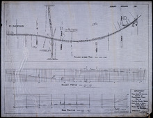
Plan of Proposed Railway Crossing North River to Mount Edward Roads
Description: Plan of proposed Railway crossing North River to Mount Edward Road. Department of Public Works and Highways, Province of Prince Edward Island. Plan shows 3 drawings consisting of the Railway &… more
Province: Prince Edward Island
Type: cadastral maps, transportation maps
Date Created: 1949
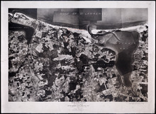
Prince Edward Island National Park: Covehead - Tracadie Section 1937
Description: Prince Edward Island National Park. Covehead - Tracadie section. Lots 34 and 35. Aerial photograph. Department of Mines and Resources, Mines and Geology Branch. Bureau of Geology and Topography. The… more
Province: Prince Edward Island
Type: cadastral maps, aerial photographs
Date Created: 1937

Prince Edward Island National Park: New London - Rustico Section 1937
Description: Prince Edward Island National Park, New London - Rustico section, Lots 22, 23 and 24. Aerial photograph. Department of Mines and Resources, Mines and Geology Branch, Bureau of Geology and Topography.
Province: Prince Edward Island
Type: cadastral maps
Date Created: 1937

Prince Edward Island National Park: Rustico Island and Brackley Beach Sections
Description: Prince Edward Island National Park. Rustico Island and Brackley Beach sections. Lots 24, 33 and 34. Department of Mines and Resources, Mines and Geology Branch, Bureau of Geology and Topography.
Province: Prince Edward Island
Type: cadastral maps, geological maps
Date Created: 1937

Plan of that part of Lot or Township No. 55, lying North: lying North of Boughton River shewing the…
Description: Plan of that part of Lot or Township 55 lying north of Boughton River showing the situation of the respective plots as coloured green which are still in the Crown. The map shows bodies of water such… more
Province: Prince Edward Island
Type: cadastral maps
Date Created: 1845

Lot 6: No. 19
Description: Plan of Lot 6 (No. 19). Cunard Estate. Shows names of residents, acreage, and some land conveyance references, bodies of water such as rivers, and roads.
Province: Prince Edward Island
Type: cadastral maps
Plan of part of The Western Road.: W. Curtis
Description: (No. 46). The map shows a plan of the Western Road from St. Eleanor's to Lot 10. The road passes through Lots 10, 11, 12, 13, 14, 16 and 17. The map shows part of the Ellis River and other… more
Province: Prince Edward Island
Type: plans

Plan of Township No. 4: Compiled from the plans, leases, deeds, and other documents on file in the…
Description: The map shows Lot 4 divided into parcels of land with the names of residents, their acreage amounts and land conveyance references. The map shows roads in a light brown colour. It shows the P.E.I.… more
Province: Prince Edward Island
Type: cadastral maps
Date Created: 1911-06
Plan of Township No. 11 in Prince Edward Island: Surveyed by A. Anderson Land Surveyor
Description: Plan of Lot 11 (No. 32). Stewart Estate. Shows names, acreage, and land conveyance references for some residents, bodies of water such as coves, rivers, roads, and a nautical compass.
Province: Prince Edward Island
Type: cadastral maps
Plan of Township No. 47 in Prince Edward Island: compiled from the old plans and surveys on file in…
Description: The map, which appears to be incomplete, shows Lot 47 divided into parcels of land with names of residents, acreage amounts and land conveyance references. The map shows roads, rivers, streams and… more
Province: Prince Edward Island
Type: cadastral maps
Plan shewing the situation of a Mill-pond Right on Lots 6 and 7, purchased from Samuel Sweet, by…
Description: Plan of part of Lots 6 and 7 showing the situation of a Mill-pond right purchased from Samuel Sweet by Richard Smallman and Chas. Crossman. The mill pond is located in the area where Lots 5, 6 and 7… more
Province: Prince Edward Island
Type: cadastral maps
Part of Lot No. 26
Description: Plan of part of Lot 26 (No.3). Plan traced[?] by J. Plaw from a survey by Mr. Major[?]. The maps shows part of Lot 26 (the Centreville area) divided into parcels of land with the names of residents… more
Province: Prince Edward Island
Type: cadastral maps
Date Created: 1810-05-23

Plan of Township No. 64: compiled from the proprietors' plans, descriptions in leases and…
Description: The map shows Lot 64 divided into parcels of land with names of residents, their acreage amounts and land conveyence references. Land information written in black indicates government land;… more
Province: Prince Edward Island
Type: cadastral maps
Date Created: 1920
Plan of Township No. 20.: Compiled from Surveys by Jas. Stewart, L. W. Gall, George Wright, Joseph…
Description: Plan of Lot 20. The map shows Lot 20 divided into parcels of land with names of some residents and some acreage amounts. The map notes freehold land. Shows roads in a light brown colour, marsh areas… more
Province: Prince Edward Island
Type: cadastral maps

Plan of Township No. 5: compiled from plans, leases, deeds, and other documents on file in the Land…
Description: Plan of Lot 5 compiled from plans, leases, deeds, and other documents on file in the Land Office. The map shows Lot 5 divided into parcels of land with names of residents, their acreage amounts and… more
Province: Prince Edward Island
Type: cadastral maps
Date Created: 1911-09

Plan of Town Lots at Cascumpec Point. Township No. 5.: Compiled and corrected from Surveys by John…
Description: Plan of Town Lots at Cascumpec Point, Lot 5. The map shows Cascumpec Point divided into parcels of land (most of them numbered) with names of residents. Shows land belonging to J. C. Pope outlined in… more
Province: Prince Edward Island
Type: cadastral maps
Date Created: 1877-08-01

Plan of Cascumpec Point Copied from a Plan in the Public Lands Departt. furnished by John Ball. L.…
Description: Plan of Cascumpec Point, Lot 5. The map shows numbered parcels of land on Cascumpec Point with names of residents and some land conveyance references. The legend indicates that parcels are outlined… more
Province: Prince Edward Island
Type: cadastral maps
Date Created: 1885-06
Plan of Township No. 6: Compiled from plans, leases, deeds, and other documents on file in the Land…
Description: The map shows Lot 6 divided into parcels of land with names of residents, their acreage amounts and land conveyance references handwritten in black and red ink. Shows the P.E.I. Railway in red, roads… more
Province: PE
Type: cadastral maps
Date Created: 1912-01
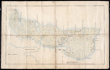
Plan of Île Saint-Jean: The Island of Saint John
Description: Plan of Ile Saint-Jean / the Island of Saint John. The map shows Prince Edward Island and a portion of the mainland. It identifies settlements, bays, harbours, rivers and islands. Sandy areas are… more
Province: Prince Edward Island
Type: topographic maps
Date Created: 1760
Plan Showing the Situation of Joseph Hammil's Farm on Lot No. 2. Containing Thirty acres on…
Description: Plan of part of Lot 2 showing Joseph Hammill's Farm containing 30 acres. The map shows Joseph Hammill's 30-acre parcel shaded in a greenish colour. It also shows the adjacent parcel of John… more
Province: PE
Type: cadastral maps

Prince Edward Island
Publisher: Chas. E. Goad, Civil Engineer
Type: fire insurance maps
Date Issued: 1888
Date Modified: 1910-08, 1917-07
Plan of the Estate of the Hon. Spencer Cecil Brabazon Ponsonby Fane Situate on Lot or Township No.…
Description: Plan of Lot 53 showing the estate of the Hon. Spencer Cecil Brabazon Ponsonby Fane. Copied by R.T. Weeks. Shows names and acreage of some residents, roads, and rivers such as Morell.
Province: Prince Edward Island
Type: cadastral maps
Plan of Lot or Township No. 53, shewing the positions of the respective boundaries thereof. Those…
Description: Plan of Lot 53 showing the position of the boundaries of the Melville, Selkirk and Westmoreland Estates (No.5). Shows names and acreage of a few residents, bodies of water such as rivers (Brudnell),… more
Province: Prince Edward Island
Type: cadastral maps
Royalty of Georgetown
Description: Plan of Lot 53 showing the estate of Lady Westmoreland. Shows names of residents and acreage, roads, and bodies of water such as rivers (Montague). Also shows the division line between the estate of… more
Province: Prince Edward Island
Type: cadastral maps
Plan Township No. 53. comprising parts of the Melville, Selkirk, and Fane Estates. Compiled and…
Description: Plan of Lot 53 comprising parts of the Melville, Selkirk and Fane Estates (No.144). Shows names, acreage, and land conveyance references for some residents, bodies of water such as rivers, and… more
Province: Prince Edward Island
Type: cadastral maps
Plan of Pierce Gaul's Estate Montague-Bridge
Description: Plan of Pierce Gaul's Estate, Montague Bridge, Lot No.52. The map shows the Montague River, streets, and buildings. more
Province: Prince Edward Island
Type: cadastral maps
Date Created: 1877-05

Plan of Lot or Township No. 51 in Kings County P. E. Island
Description: Plan of Lot 51 (No.139) Colour code shows freehold and unsold portions. Sir Graham Montgomery Estate. Shows names, acreage, and land conveyance references of some residents, and roads.
Province: Prince Edward Island
Type: cadastral maps
Plan of Township No. 50, the Property of Maria Susanna Matilda Fanning
Description: Plan of Lot 50, the property of Maria Susanna Matilda Fanning. Shows names of residents, acreage, and land conveyance references, bodies of water such as rivers (Vernon), bays (Pownal), and roads.… more
Province: Prince Edward Island
Type: cadastral maps

Plan of certain tracts of land at or near Orwell according to registered deeds, and two surveys…
Description: Plan of part of Lot 50. Clark's Corner, Orwell. Shows certain tracts of land at or near Orwell according to registered deeds and two surveys. Rough copy included. more
Province: Prince Edward Island
Type: cadastral maps

Plan of Part of Township No. 49. Bedford Parish. Queens County. P. E. Island.
Description: Plan of part of Lot 49 (No.135). One of the plans referred to in the deed from Sir Edward, William, and Laura Cunard to the Commissioner of Public Lands, July 13, 1866. The portion of land intended… more
Province: Prince Edward Island
Type: cadastral maps
Date Created: 1850
Plan of part of Lot 50
Description: Plan of part of Lot 50 (No.13). Area east of the Murray Harbour Road, north of the Dundee Road, and south of Georgetown Road. Shows names of residents.
Province: Prince Edward Island
Type: cadastral maps

Plan of Township Number 49. Shewing "Cunard" portion borderd. yellow. "Loan Act…
Description: Plan of Lot 49 showing Cunard portion bordered yellow, Loan Act Land bordered green, and remainder of Township (No.134). Copied from Meacham's Atlas by Owen Curtis. Shows names of residents,… more
Province: Prince Edward Island
Type: cadastral maps
Date Created: 1883-08
Plan of Lot 48 east of Fullerton's Creek
Description: Plan of that part of Lot 48 east of Fullerton's Creek. Shows names of residents and acreage. (No.13 in Plan Book) (Also, No.924) more
Province: Prince Edward Island
Type: cadastral maps
Date Created: 1874-01
Lot 45 (No.122)
Description: Plan of the northeastern part of Lot 45 (No.122). Shows names of residents and acreage and a nautical compass.
Province: Prince Edward Island
Type: cadastral maps
Plan of Township No. 44. Corrected from Surveys by Owen Curtis, J. C. Underhay and others. By Thos…
Description: Plan of Lot 44 (No.118) corrected by Thomas MacKinlay from surveys by Owen Curtis, J.C. Underhay and others. Cunard Estate. Shows some residents' names, acreage, and land conveyance references,… more
Province: Prince Edward Island
Type: cadastral maps
Date Created: 1887-09
Plan of Township No. 44.
Description: Plan of Lot 44 (No.120). Cunard Estate. Shows names and acreage of some residents, bodies of water such as rivers and gulfs, roads, and a mills (MacGowans).
Province: Prince Edward Island
Type: cadastral maps