Displaying 163 - 189 of 533
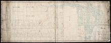
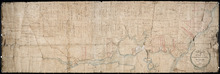
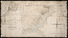
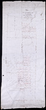
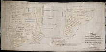
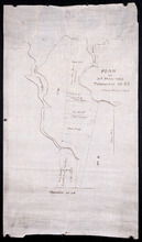
Plan of Lot or Township No 59: Two Thirds being the property of The Messrs Montgimeries being 13,…
Description: Plan of Lot 59 (No.157). Two thirds being the property of the Messrs. Montgomeries being 13,064 acres. One third, the property of Earl Selkirk. Plan copied by Jas. J. Bevan. Date of plan: April 1848… more
Province: Prince Edward Island
Type: cadastral maps
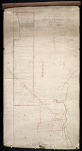
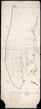
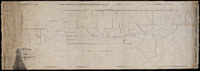
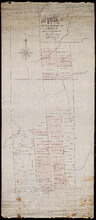
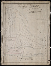
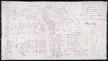
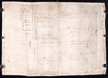
A Plan of the North or C Division of Lot or Township No. 59: Kings County, P. E. Island
Description: A plan of the north division of Lot 59 (No.159). James Montgomery Estate. The map shows the C Division of Lot 59 divided into numbered parcels of land with the names of occupants and their… more
Province: Prince Edward Island
Type: cadastral maps

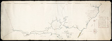
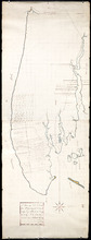
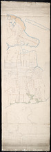
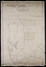
Plan of Lot or Township No 59 Two Thirds being the property of Sir James Montgomery Brothers being…
Description: Plan of Lot 59. Two thirds being the property of Sir James Montgomery & Brothers, and one third the property of Earl Selkirk. The map shows bodies of water such as rivers, residents, lots, and… more
Province: Prince Edward Island
Type: cadastral maps
Date Created: 1842-03-01
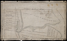
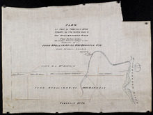
Lot 50
Description: Plan of Lot 63 (No.2). The property of J. Cambridge. Mainly outline. Shows a few residents, lots, bodies of water, islands, and roads.
Province: Prince Edward Island
Type: cadastral maps
Date Created: 1829-04
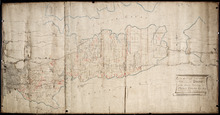
Plan of Township No 63, St. Andrews Parish Kings County: Prince Edward Island
Description: Plan of Lot 63. Eastern part shows names of residents, lots, acreage, bodies of water such as rivers, and bays, and roads.
Province: Prince Edward Island
Type: cadastral maps
Date Created: 1842
Plan of Township No 63 St. Andrew's Parish Queens County: P.E.Island
Description: Plan of Lot 63. This is one of the plans referred to in the Deed from the Cunards to the Commissioner of Public Lands, July 15, 1866. The map shows lots, residents, roads, acreage and bodies of water… more
Province: Prince Edward Island
Type: cadastral maps
Date Created: 1851
A Plan of Lot No 64: The property of J. Cambridge Esq Situate in Kings County P.E.Island
Description: Plan of Lot 64. The property of J. Cambridge. Shows some residents. Copy by James Richard. The map shows lots, residents, roads, cities, towns, and bodies of water.
Province: Prince Edward Island
Type: cadastral maps
Date Created: 1829-03
A Plan of Lot No. LXIV: The Property of J. Cambridge Esqr. Situate in Kings County P. E. Island…
Description: Plan of Lot 64 (No. 2). The property of J. Cambridge. The map shows Lot 64 partially divided into parcels of land with the names of residents and their acreage amounts. The map shows roads, which are… more
Province: Prince Edward Island
Type: cadastral maps
Date Created: 1829-03
Plan of Half Township No. 65 One of the Estates of the Misses Fanning - Prince Edward Island: From…
Description: Plan of the eastern half of Lot 65 (No. 175). The Misses Fanning Estate. The map shows lots, residents, roads, and bodies of water such as rivers.
Province: Prince Edward Island
Type: cadastral maps
Plan of the Western Portion of Township No. 65: containing 5250 acres and belonging to Mrs. Lydia…
Description: Plan of the western portion of Lot 65 (No.173). Estate of Mrs Lydia Wright. Roads, leased land[?] and freehold land on the Estate of Mrs. Lydia Wright. Tenant names appear on the sub-lots, which are… more
Province: Prince Edward Island
Type: cadastral maps
Date Created: 1841
Plan of Lot or Township No. 66: from the latest Surveys by Jos. Ball Surveyor General's Office…
Description: Plan of Lot 66. Gives list of settlers. The map shows Lot 66 divided into numbered parcels of land. Along the side there is a corresponding list of parcel numbers and settlers' names handwritten… more
Province: Prince Edward Island
Type: cadastral maps
Date Created: 1856-08-04
Plan of Lot or Township No. 66 from actual survey.
Description: Plan of Lot or Township No. 66 from actual survey. Rolled paper on fabric backing; handwriting on verso. The map shows Lot 66 divided into parcels of land with the names of residents and their… more
Province: Prince Edward Island
Type: cadastral maps
Plan of the Moiety of Lot or Township No 29 of the Estate of Viscount elville situated in Prince…
Description: Plan of the east moiety of Lot 29 (No.2). Part of the estate of Lord Viscount Melville. The map shows lots, residents, roads, and bodies of water such as rivers.
Province: Prince Edward Island
Type: cadastral maps
Plan Showing the situation of the Estate of Mr. Clement White on Lot or Township No. 32
Description: Plan of part of Lot 32 (No.21). The estate of Mr. Clement White. The map shows lots, residents, roads, and York (or North) River.
Province: Prince Edward Island
Type: cadastral maps
Date Created: 1874-01
Plan of the Property of Mrs Smith situate in Township No 33 in Prince Edward Island: Mrs S's…
Description: Plan of part of Lot 33 showing the property of Mrs. S.W. Smith. The map shows lots, residents, acreage, roads, and water.
Province: Prince Edward Island
Type: cadastral maps
Plan of the Property of Ms S W Smith Situate on Township No 33 in Prince Edward Island: Mrs S'…
Description: Plan of part of Lot 33, showing the property of Mrs. S.W. Smith. The map shows lots, residents, roads, and bodies of water such as rivers.
Province: Prince Edward Island
Type: cadastral maps
Plan of Lot 35
Description: Plan of Lot 35 (No.95). Shows some residents, lots, roads, bodies of water and foliage.
Province: Prince Edward Island
Type: cadastral maps
Part of Lot 35 in Queens county
Description: Plan of part of Lot 35 (No.631). The Estate of John A. MacDonald. Shows area around Johnston's River. Date of plan: post 1811, after the death of Captain MacDonald. The map shows lots, residents… more
Province: Prince Edward Island
Type: cadastral maps
Plan of part of Township Number 35 situate on the North side of the Hillsborough River.: Those…
Description: Plan of Lot 35 (No.1). North side of the Hillsborough River. Property of Rev. John MacDonald. From a tracing by W.C. Harris. The map shows lots, residents, roads, and bodies of water.
Province: Prince Edward Island
Type: cadastral maps
Date Created: 1878-03-21
Plan of Part of Township no 35 on Bedford Bay
Description: Plan of part of Lot 35 (No.631) bordering on Bedford Bay. The map shows lots, residents, roads, and various bodies of water.
Province: Prince Edward Island
Type: cadastral maps
Plan of Part of Township No. 35 on the North Side of the Hillsborough River
Description: Plan of part of Lot 35 on the north side of the Hillsborough River. The map shows lots, residents, roads, Bedford Bay and foliage.
Province: Prince Edward Island
Type: cadastral maps
Plan of Part of Township No. 35 situate on the South Side of the Hillsborough River
Description: Plan of part of Lot 35 situate on the south side of the Hillsborough River. The property of John Apollinarius MacDonnell. Plan copied by R.T. Weeks. The map shows lots, residents, roads, islands, and… more
Province: Prince Edward Island
Type: cadastral maps
Plan of St Martins Township No 35
Description: Plan of part of Lot 35, St. Martins. The map shows lots, residents, and bodies of water such as rivers.
Province: Prince Edward Island
Type: cadastral maps
Plan if the Southren Moiety of Township No 36 Part of the Estate of the Rev: John Alister Somerlet…
Description: Plan of the southern moiety of Lot 36 (No.2). Part of the estate of the Rev. John Alister Somerlet MacDonald. From a tracing by W.C. Harris. The map shows lots, residents, a pond, and roads.
Province: Prince Edward Island
Type: cadastral maps
Date Created: 1878-03-22
Plan of Lot 37
Description: Plan of Lot 37, north of the Hillsborough River. Shows some residents, lots, roads, and bodies of water.
Province: Prince Edward Island
Type: cadastral maps
Surveyor General's Plan for south western half of Lot 37
Description: Surveyor General's Plan for south western half of Lot 37 (No.1). The map shows lots, residents, and bodies of water. more
Province: Prince Edward Island
Type: cadastral maps
Plan of part of Lot 38
Description: Plan of part of Lot 38 (No.7). Part of Mrs. Burns' property, sold to LeLacheur and others. The map shows lots, and residents. more
Province: Prince Edward Island
Type: cadastral maps