Displaying 217 - 297 of 297
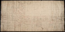
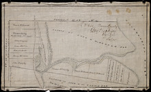
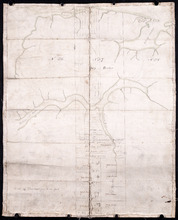
Plan of the Northern Moiety of Lot or Township No. 48 in Prince Edward Island, Copied from the Plan…
Description: Plan of the northern moiety of Lot 48 (No.129). Shows the property of Miss Frances Crooke, R.G. Cuninghame, Theo. Desbrisay, and the Misses Lawton. The map shows lots, residents, roads, and bodies of… more
Province: Prince Edward Island
Type: cadastral maps
Date Created: 1836
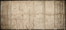
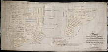
Plan of Township No. 50 The Estate of the Misses[?] Fanning, Prince Edward Island: From actual…
Description: Plan of Lot 50. Fanning Estate. The map shows lots, residents, bodies of water and roads.
Province: Prince Edward Island
Type: cadastral maps
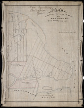
Plan of Lot 57
Description: Plan of Lot 57 (No.2) showing the lot divided into quarters. Also shows Refugee Share drawn for in Council, 12 February, 1784.
Province: Prince Edward Island
Type: cadastral maps
Date Created: 1784-02-12
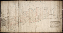
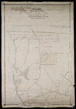
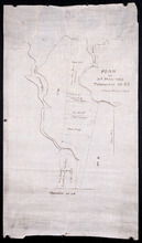
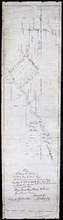
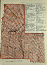
A Plan of the undisposed of Parts of Lot No. 57: in Queens County in Prince Edward Island
Description: A plan of the undisposed of parts of Lot 57. Surveyed by Rod'k Campbell. The map shows parcels of land with names of owners or occupants and their corresponding acreage amounts handwritten in… more
Province: Prince Edward Island
Type: cadastral maps
Date Created: 1860
Plan of Lot 58
Description: Plan of Lot 58 divided into four sections. Shows Refugee Shares drawn for 12th February, 1784. Shown are lots, residents, and bodies of water.
Province: Prince Edward Island
Type: cadastral maps
Date Created: 1784-02-12

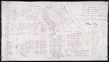
A Plan of the undisposed of Part, of Lot No. 38 in Queens County in Prince Edward Island
Description: A plan of the undisposed part of Lot 58 (No.154). Shows residents, lots, roads, and water. Surveyed by Rod'k Campbell. more
Province: Prince Edward Island
Type: cadastral maps
Date Created: 1860
Plan of Half Township No. 65 One of the Estates of the Misses Fanning - Prince Edward Island: From…
Description: Plan of the eastern half of Lot 65 (No. 175). The Misses Fanning Estate. The map shows lots, residents, roads, and bodies of water such as rivers.
Province: Prince Edward Island
Type: cadastral maps
Plan of the Western Portion of Township No. 65: containing 5250 acres and belonging to Mrs. Lydia…
Description: Plan of the western portion of Lot 65 (No.173). Estate of Mrs Lydia Wright. Roads, leased land[?] and freehold land on the Estate of Mrs. Lydia Wright. Tenant names appear on the sub-lots, which are… more
Province: Prince Edward Island
Type: cadastral maps
Date Created: 1841
Plan of the Moiety of Lot or Township No 29 of the Estate of Viscount elville situated in Prince…
Description: Plan of the east moiety of Lot 29 (No.2). Part of the estate of Lord Viscount Melville. The map shows lots, residents, roads, and bodies of water such as rivers.
Province: Prince Edward Island
Type: cadastral maps
Plan Showing the situation of the Estate of Mr. Clement White on Lot or Township No. 32
Description: Plan of part of Lot 32 (No.21). The estate of Mr. Clement White. The map shows lots, residents, roads, and York (or North) River.
Province: Prince Edward Island
Type: cadastral maps
Date Created: 1874-01
Plan of the Property of Mrs Smith situate in Township No 33 in Prince Edward Island: Mrs S's…
Description: Plan of part of Lot 33 showing the property of Mrs. S.W. Smith. The map shows lots, residents, acreage, roads, and water.
Province: Prince Edward Island
Type: cadastral maps
Plan of the Property of Ms S W Smith Situate on Township No 33 in Prince Edward Island: Mrs S'…
Description: Plan of part of Lot 33, showing the property of Mrs. S.W. Smith. The map shows lots, residents, roads, and bodies of water such as rivers.
Province: Prince Edward Island
Type: cadastral maps
Plan of Lot 35
Description: Plan of Lot 35 (No.95). Shows some residents, lots, roads, bodies of water and foliage.
Province: Prince Edward Island
Type: cadastral maps
Part of Lot 35 in Queens county
Description: Plan of part of Lot 35 (No.631). The Estate of John A. MacDonald. Shows area around Johnston's River. Date of plan: post 1811, after the death of Captain MacDonald. The map shows lots, residents… more
Province: Prince Edward Island
Type: cadastral maps
Plan of part of Township Number 35 situate on the North side of the Hillsborough River.: Those…
Description: Plan of Lot 35 (No.1). North side of the Hillsborough River. Property of Rev. John MacDonald. From a tracing by W.C. Harris. The map shows lots, residents, roads, and bodies of water.
Province: Prince Edward Island
Type: cadastral maps
Date Created: 1878-03-21
Plan of Part of Township no 35 on Bedford Bay
Description: Plan of part of Lot 35 (No.631) bordering on Bedford Bay. The map shows lots, residents, roads, and various bodies of water.
Province: Prince Edward Island
Type: cadastral maps
Plan of Part of Township No. 35 on the North Side of the Hillsborough River
Description: Plan of part of Lot 35 on the north side of the Hillsborough River. The map shows lots, residents, roads, Bedford Bay and foliage.
Province: Prince Edward Island
Type: cadastral maps
Plan of Part of Township No. 35 situate on the South Side of the Hillsborough River
Description: Plan of part of Lot 35 situate on the south side of the Hillsborough River. The property of John Apollinarius MacDonnell. Plan copied by R.T. Weeks. The map shows lots, residents, roads, islands, and… more
Province: Prince Edward Island
Type: cadastral maps
Plan of St Martins Township No 35
Description: Plan of part of Lot 35, St. Martins. The map shows lots, residents, and bodies of water such as rivers.
Province: Prince Edward Island
Type: cadastral maps
Plan if the Southren Moiety of Township No 36 Part of the Estate of the Rev: John Alister Somerlet…
Description: Plan of the southern moiety of Lot 36 (No.2). Part of the estate of the Rev. John Alister Somerlet MacDonald. From a tracing by W.C. Harris. The map shows lots, residents, a pond, and roads.
Province: Prince Edward Island
Type: cadastral maps
Date Created: 1878-03-22
Plan of Lot 37
Description: Plan of Lot 37, north of the Hillsborough River. Shows some residents, lots, roads, and bodies of water.
Province: Prince Edward Island
Type: cadastral maps
Surveyor General's Plan for south western half of Lot 37
Description: Surveyor General's Plan for south western half of Lot 37 (No.1). The map shows lots, residents, and bodies of water. more
Province: Prince Edward Island
Type: cadastral maps
Plan of the division line between Lots 48 and 49
Description: Plan of the division line between Lots 48 and 49. The map shows lots, residents, roads, and bodies of water.
Province: Prince Edward Island
Type: cadastral maps
Date Created: 1841-06
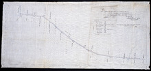
Plan of the division line between Lots 31 and 65, the commencement of which was set by the…
Description: Plan of the division line between Lots 31 and 65, the commencement of which was set by the Commissioners for establishing boundary lines. (No.1) The map shows lots, roads, and rivers.
Province: Prince Edward Island
Type: cadastral maps
Date Created: 1837-08-26
Royalty of Charlotettown
Description: Plan showing the line dividing Lots 33 and 34. (No.10). The map shows lots, residents, roads, and bodies of water.
Province: Prince Edward Island
Type: cadastral maps
Plan showing the point of commencement of the division line between Lots 48 and 49, established by…
Description: Plan showing the point of commencement of the division line between Lots 48 and 49, established by the Commissioners under the Boundary Bill, July 30, 1840. The map shows lots, residents, roads,… more
Province: Prince Edward Island
Type: cadastral maps
Date Created: 1840-08
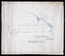
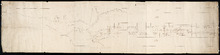
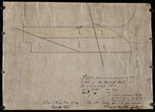
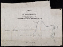
Plan of a New Road from the Flat River Road (marked A, B, C, D, E, F.) to the shore of the straits…
Description: Plan of a New Road from the Flat River Road to the shore of the straits. On Lots 60 and 62. The map shows lots, residents, roads, and water.
Province: Prince Edward Island
Type: cadastral maps
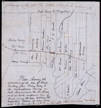
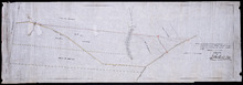
Plan shewing the situation of the line of road leading from Cherry Valley to the contemplated…
Description: Plan showing the situation of the line of road leading from Cherry Valley to the contemplated bridge on Seal River and the 24 chains and 50 links unopened line of road along the line between the… more
Province: Prince Edward Island
Type: cadastral maps
Plan of the road from Kelly's Cove to the line between John F. Baker and Frank Bovyer thro…
Description: Plan of the road from Kelly's Cove to the line between John F. Baker and Frank Bovyer through Bunbury, Lot 48. Ordered to be widened. The map shows lots, residents, roads, and water. more
Province: Prince Edward Island
Type: cadastral maps
Proposed New Road from Rustico Road to Brookfield Road
Description: Proposed New Road from Rustico Road to Brookfield Road. The map shows lots, roads, residents, and a swamp.
Province: Prince Edward Island
Type: cadastral maps
Plan showing the position of 2 new lines of road from R. McMillan's Mills to Fredericton…
Description: Plan showing the position of 2 new lines of road from R. McMillan's Mills to Fredericton Station. Also through McMillan's land from French Settlement. Also from Trout River Bridge to Road… more
Province: Prince Edward Island
Type: cadastral maps
Plan Shewing the Situation of the Presen road from Point Prim Also the proposed road A.B.C.orD.
Description: Plan showing the situation of the present road from Point Prim. Also, the proposed one. The map shows lots, residents, water and foliage.
Province: Prince Edward Island
Type: cadastral maps
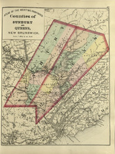
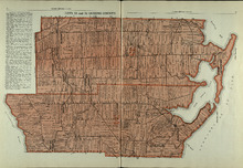
Counties of Sunbury and Queens: New Brunswick
Description: The map shows the counties of Sunbury and Queens in New Brunswick. Shown are railroads, stations and junctions, rivers, lakes, and creeks.
Publisher: Roe Brothers
Province: New Brunswick
Type: geological maps
Date Issued (Source): 1878
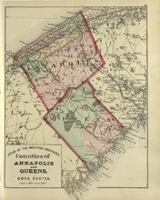
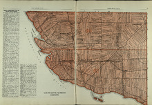
Coutnies of Annapolis and Queens : Nova Scotia
Description: The map shows the counties of Annapolis and Queens in Nova Scotia. Shown are rivers, roads, railroads, stations, lakes, harbours, cities, and towns.
Publisher: Roe Brothers
Province: Nova Scotia
Type: geological maps
Date Issued (Source): 1878
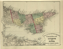
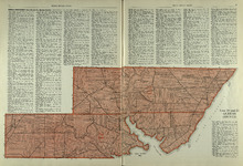
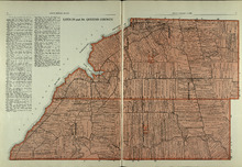
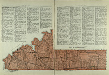
Counties of Queens and Kings: Prince Edward Island
Description: The map shows the counties of Queens and Kings in Prince Edward Island. Shown are bays, points, rivers, capes, coves, harbours, roads, railroads, cities, and towns.
Publisher: Roe Brothers
Province: Prince Edward Island
Type: geological maps
Date Issued (Source): 1878
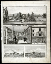
Property Sketches - Page 38
Description: Property sketches of the Residence of Hon. W. W. Sullivan, Charlottetown, P.E.I.; E.W. Taylor' Jewelry Store - interior and exterior, South Side Queen Square, Charlottetown, P.E.I.; The farms of… more
Publisher: J. H. Meacham & company
Province: Prince Edward Island
Type: image
Date Issued (Source): 1880
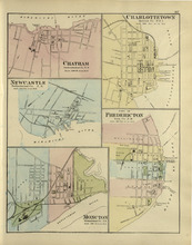
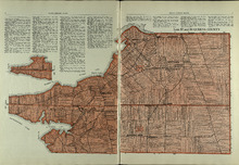
Chatham : Charlottetown : New Castle : City of Fredricton : Moncton: Northumberland Co. N.B..…
Description: The map shows Catham in the Northumberland county. New Brunswick. Shown are a river, wharf, streets, buildings, lots and a ferry crossing. The map shows Charlottetown in Queens county, Prince Edward… more
Publisher: Roe Brothers
Province: New Brunswick, Prince Edward Island
Type: geographical maps
Date Issued (Source): 1878

Plan of Lot Seventeen: Prince Co., P.E.I.
Description: The map shows lot 17 along with two smaller maps of lot 17 and 23. The map includes landowners and acreage, railroads and stations, roads, districts, creeks, rivers, bays, marshes, brooks, coves,… more
Publisher: J. H. Meacham & company
Province: Prince Edward Island
Type: cadastral maps
Date Issued (Source): 1880
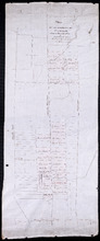
Rural Directory - Lots 27 and 28, Prince County and Lot 67, Queens county
Description: A directory listing of residents of lots 27 and 28 in Prince County and lot 67 in Queens County
Publisher: Cummins Map Co.
Province: Prince Edward Island
Type: text
Date Issued (Source): 1927
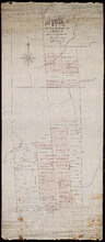
Lot No. 67: Queens County
Description: The map shows lot 67 in Queens county.Shown are roads, railroads, landowners, acreage, and Emerald Junction.
Publisher: Cummins Map Co.
Province: Prince Edward Island
Type: cadastral maps
Date Issued (Source): 1927

Plan of Lot Twenty One & Twenty: Queens Co., P.E.I.
Description: The map shows lots 21 and 20 (coloured in pink) in Queens county that border Prince county. The map names roads, landowners and acreage, creeks, gulfs, rivers, coves, fishing stations, post offices,… more
Publisher: J. H. Meacham & company
Province: Prince Edward Island
Type: cadastral maps
Date Issued (Source): 1880
Lot 20 and 21: Queens County
Description: The map shows lots 20 and 21 in Queens county. Shown are the Gulf of St. Lawrence, New London River and Bay, capes, ponds, rivers, landowners, acreage, and roads.
Publisher: Cummins Map Co.
Province: Prince Edward Island
Type: cadastral maps
Date Issued (Source): 1927
Lots 22 and 23: Queens County
Description: The map shows lots 22 and 23 in Queens county. Shown are rivers, roads, railroads, landowners, acreage, New London bay and the Gulf of St. Lawrence.
Publisher: Cummins Map Co.
Province: Prince Edward Island
Type: cadastral maps
Date Issued (Source): 1927

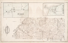
Victoria, Lot 29; Map of Lennox Island
Description: The page displays map of Victoria in Lot 29. Shown are roads and streets, a harbour, wharfs, landowners, post offices, buildings and school houses. Compass. The page also displays a map of Lennox… more
Publisher: J. H. Meacham & company
Province: Prince Edward Island
Type: cadastral maps
Date Issued (Source): 1880
Lot 24: Queens County
Description: The map shows lot 24 in Queens county. Shown are the Gulf of St. Lawrence, Rustico Bay and Harbour, river, cape, roads, landowners, and acreage.
Publisher: Cummins Map Co.
Province: Prince Edward Island
Type: cadastral maps
Date Issued (Source): 1927
Plan of Lots 22 & 23 : Queens Co., P.E.I.
Description: The map shows lots 22 and 23 in Queens county. The map names roads, landowners and acreage, churches, halls, post offices, railroads, rivers, bays, and guls. Graphic compass.
Publisher: J. H. Meacham & company
Province: Prince Edward Island
Type: cadastral maps
Date Issued (Source): 1880
Rural Directory - Lots 24, 29, and 30, Queens County
Description: A directory listing of residents of lots 24, 29, and 30
Publisher: Cummins Map Co.
Province: Prince Edward Island
Type: text
Date Issued (Source): 1927
Rural Directory - Lots 29 and 30, Queens County
Description: A directory listing of residents of lots 29 and 30.
Publisher: Cummins Map Co.
Province: Prince Edward Island
Type: text
Date Issued (Source): 1927
Lots 29 and 30: Queens County
Description: The map shows lots 29 and 30 in Queens county. Shown are roads, landowners, acreage, the Northumberland Strait, Westmoreland Harbour, and Sable River.
Publisher: Cummins Map Co.
Province: Prince Edward Island
Type: cadastral maps
Date Issued (Source): 1927
Plan of Lot Twenty Four: Queens Co., P.E.I.
Description: The map shows lot 24 in Queens county. Shown are rivers, gulfs, capes harbours, wharfs, lighthouses, fishing stages and holes, seaside hotels and bath houses, churches, crosses, post offices, roads,… more
Publisher: J. H. Meacham & company
Province: Prince Edward Island
Type: cadastral maps
Date Issued (Source): 1880
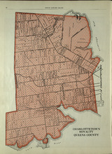
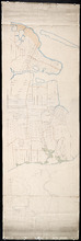
Charlottetown Royalty: Queens County
Description: The map shows the City of Charlottetown in Queens county. Shown are the Hillsborough and York Rivers. farms, landowners, acreage, roads, and railroads.
Publisher: Cummins Map Co.
Province: Prince Edward Island
Type: cadastral maps
Date Issued (Source): 1927
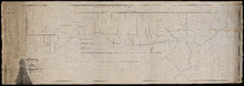
Lots 31 and 32: Queens County
Description: The map shows lots 31 and 32 in Queens county. Shown are rivers, landowners, acreage, roads, and railroads
Publisher: Cummins Map Co.
Province: Prince Edward Island
Type: cadastral maps
Date Issued (Source): 1927
Rural Directory - Lots 31 - 34, Queens County
Description: A directory listing of residents of lots 31, 32, 33, and 34.
Publisher: Cummins Map Co.
Province: Prince Edward Island
Type: text
Date Issued (Source): 1927
Rural Directory - Lots 33 and 34, Queens County
Description: A directory listing of residents of lots 33 and 34.
Publisher: Cummins Map Co.
Province: Prince Edward Island
Type: text
Date Issued (Source): 1927
Lots 33 and 34 : Queens County
Description: The map shows lots 33 and 34 in Queens county. Shown are the Gulf of St. Lawrence, Cove Head and Rustico Bay, Hillsborough River, landowners, acreage, roads, railroads, Royalty Junction and Suffolk… more
Publisher: Cummins Map Co.
Province: Prince Edward Island
Type: cadastral maps
Date Issued (Source): 1927
Lot 65: Queens County
Description: The map shows Lot 65 in Queens County. Shown are the Northumberland Strait, Hillsborough Bay, Elliott River, roads, landowners, acreage, and towns.
Publisher: Cummins Map Co.
Province: Prince Edward Island
Type: cadastral maps
Date Issued (Source): 1927
Lot 48: Queens County
Description: The map shows lot 48 in Queens county. Shown are Hillsborough River, Fullerton Creek, railroads, roads, landowners, and acreage.
Publisher: Cummins Map Co.
Province: Prince Edward Island
Type: cadastral maps
Date Issued (Source): 1927
Lots 49 and 50: Queens County
Description: The map shows lots 49 and 50 in Queens county. Shown are bays, Governor Island, points, rivers, roads, railroads, landowners, and acreage.
Publisher: Cummins Map Co.
Province: Prince Edward Island
Type: cadastral maps
Date Issued (Source): 1927
Rural Directory - Lots 49 and 50, Queens County
Description: A directory listing of residents of lots 49 and 50.
Publisher: Cummins Map Co.
Province: Prince Edward Island
Type: text
Date Issued (Source): 1927
Rural Directory - Lots 57 and 58, Queens County
Description: A directory listing of residents of lots 57 and 58.
Publisher: Cummins Map Co.
Province: Prince Edward Island
Type: text
Date Issued (Source): 1927
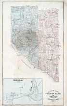
Plan of Lots Twenty Nine & Thirty: Queens Co., P.E.I.
Description: The map shows lots 29 (coloured in blue) and 30 (coloured in pink) in Queens county. The map shows straits, rivers, post offices, roads, landowners and acreage, and churches. Graphic compass.
Publisher: J. H. Meacham & company
Province: Prince Edward Island
Type: cadastral maps
Date Issued (Source): 1880
Lots 57 and 58: Queens County
Description: The map shows lots 57 and 58 in Queens county. Shown are Pinette Harbour, Northumberland Strait, Orwell Bay, rivers, roads, railroads, landowners,and acreage.
Publisher: Cummins Map Co.
Province: Prince Edward Island
Type: cadastral maps
Date Issued (Source): 1927
Lots 60 and 62: Queens County
Description: The map shows lots 60 and 62 in Queens county. Shown are the Northumberland Strait, roads, railroads, harbour, points, landowners, and acreage.
Publisher: Cummins Map Co.
Province: Prince Edward Island
Type: cadastral maps
Date Issued (Source): 1927
Plan of Lot Thirty One: Queens Co., P.E.I.
Description: The map shows lot 31 in Queens county. Shown are rivers, landowners and acreage, post offices, creeks, railroads and stations, roads, churches, a ferry, and school houses. Compass. Illustrated… more
Publisher: J. H. Meacham & company
Province: Prince Edward Island
Type: cadastral maps
Date Issued (Source): 1880
Rural Directory - Lots 60 and 62, Queens County
Description: A directory listing of residents of lots 60 and 62.
Publisher: Cummins Map Co.
Province: Prince Edward Island
Type: text
Date Issued (Source): 1927
Rural Directory - Lots 35 and 36, Queens County
Description: A directory listing of residents of lots 35 and 36.
Publisher: Cummins Map Co.
Province: Prince Edward Island
Type: text
Date Issued (Source): 1927
Lots 35 and 36: Queens County
Description: The map shows lots 35 and 36 in Queens County. Shown are Hillsborough River, Tracadie Bay, Gulf of St. Lawrence. Mill Cove, landowners, acreage, raods, and railroads.
Publisher: Cummins Map Co.
Province: Prince Edward Island
Type: cadastral maps
Date Issued (Source): 1927
Lot 37, Queens County: Lot 38 Kings County
Description: The map shows lot 37 in Queens county and lot 38 in Kings county. Shown are the Gulf of St. Lawrence, Savage Harbour, landowners, acreage, roads, railroads, and rivers.
Publisher: Cummins Map Co.
Province: Prince Edward Island
Type: cadastral maps
Date Issued (Source): 1927
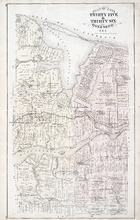
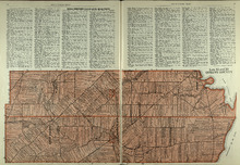
Plan of Lot Thirty Five & Thirty Six: Queens Co., P.E.I.
Description: The map shows lots 35 & 36 in Queens county. Shown are gulfs, bays, sand, coves, wharfs, rivers, ponds, creeks, fishing houses, roads, landowners and acreage, post offices, school houses,… more
Publisher: J. H. Meacham & company
Province: Prince Edward Island
Type: cadastral maps
Date Issued (Source): 1880
Plan of Lot Thirty Two: Queens Co., P.E.I.
Description: The map shows lot 32 in Queens county. Shown are roads, landowners and acreage, railroad and station, post offices, rivers, churches, and coves. Compass.
Publisher: J. H. Meacham & company
Province: Prince Edward Island
Type: cadastral maps
Date Issued (Source): 1880

Plan of Lot Thirty Seven : Plan of Lot Thirty Eight: Queens Co., P.E.I.. Kings Co., P.E.I.
Description: The map shows lot 37 (coloured in pink) in Queens county, and lot 38 (coloured in blue) in Kings county. Shown are roads, railroads, landowners and acreage, rivers, ponds, harbours, gulfs, creeks,… more
Publisher: J. H. Meacham & company
Province: Prince Edward Island
Type: cadastral maps
Date Issued (Source): 1880
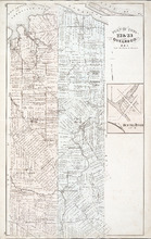
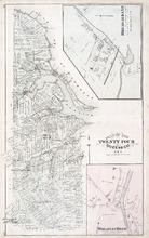
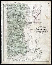
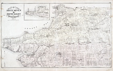
Plan of Lot Fourty Eight: Queens Co., P.E.I.
Description: The map showing lots 48 in Queens county. Shown are the commissioners line, rivers, coves, marsh, creeks, ponds, lakes, roads, landowners and acreage, asylum, hospital, and post offices. Graphic… more
Publisher: J. H. Meacham & company
Province: Prince Edward Island
Type: cadastral maps
Date Issued (Source): 1880
Plan of Lots 49 & 50: Queens Co., P.E.I.
Description: The map shows lot 49 & 50 in Queens County. Shown are roads, landowners and acreage, lakes, bays, coves, wharfs, post offices, churches, and schools. Graphic compass
Publisher: J. H. Meacham & company
Province: Prince Edward Island
Type: cadastral maps
Date Issued (Source): 1880
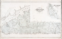
Plan of Lot Fourty Five: Kings Co., P.E.I.
Description: The map shows Lot 45 in Kings county. Shown are the gulf, bay, rivers, coves, post offices, cross, mills, roads, railroad, landowners and acreage, churches, hospital, harbour, and sand. Compass.
Publisher: J. H. Meacham & company
Province: Prince Edward Island
Type: cadastral maps
Date Issued (Source): 1880
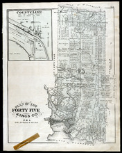
Plan of Lots Fifty Seven & Fifty Eight: Queens Co., P.E.I.
Description: The map shows lots 57 & 58 in Queens county. Includes an inset map of Prim Island / Point Prim. Shown are roads, landowners and acreage, crosses, rivers, ponds, creeks, bays, coves, sand, wharfs… more
Publisher: J. H. Meacham & company
Province: Prince Edward Island
Type: cadastral maps
Date Issued (Source): 1880
Plan of Lot Sixty & Sixty Two: Queens Co., P.E.I.
Description: The map shows lots 60 & 62 in Queens county. Shown are roads, landowners and acreage, rivers, straits, ponds, bays, creeks, sand, post offices, mills, churches, and school houses. Graphic compass.
Publisher: J. H. Meacham & company
Province: Prince Edward Island
Type: cadastral maps
Date Issued (Source): 1880
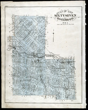
Plan of Lot Sixty Seven: Queens Co., P.E.I.
Description: The map shows Lot 67 in Queens county. Shown are roads, landowners and acreage, railroads and stations, post offices, church, and school houses. Compass.
Publisher: J. H. Meacham & company
Province: Prince Edward Island
Type: cadastral maps
Date Issued (Source): 1880
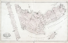
Plan of Lot 65 : Queens Co., P.E.I.
Description: The map shows Lot 65 in Queens county. Shown are roads, landowners and acreage, creeks, rivers, straits, marshes, brooks, coves, sand, reef, fishing stage, wharfs, post offices, mills, churches,… more
Publisher: J. H. Meacham & company
Province: Prince Edward Island
Type: cadastral maps
Date Issued (Source): 1880
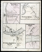
Port Selkirk Farm or Brush Wharf, Stanley Bridge: Murray Harbour South, and Vernon River Bridge
Description: The map shows Port Selkirk Farm or Brush Wharf lot 57 in Queens county. Shown are a river, wharf, road and street, landowners, and measurements. Compass.
Publisher: J. H. Meacham & company
Province: Prince Edward Island
Type: cadastral maps
Date Issued (Source): 1880
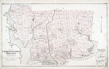
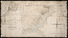
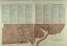
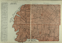
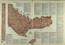
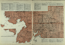
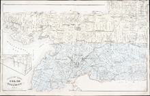
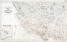
Plan of Charlottetown Royalty: Queens Co., P.E.I.
Description: The map shows the city of Charlottetown and a plan for lots. Shown are rivers, creeks, roads, railroad and stations, landowners and acreage, mills, park, bridge, college, farms, asylums, and a… more
Publisher: J. H. Meacham & company
Province: Prince Edward Island
Type: cadastral maps
Date Issued (Source): 1880

Montague Bridge Lots 59 & 52: Kings Co., P.E.I.
Description: The map shows lots 59 & 52 in Montague Bridge, Kings county. Shown are rivers, wharfs, shipyards, roads, landowners and acreage, halls, churches, buildings and businesses. Compass.
Publisher: J. H. Meacham & company
Province: Prince Edward Island
Type: cadastral maps
Date Issued (Source): 1880