Displaying 190 - 216 of 239
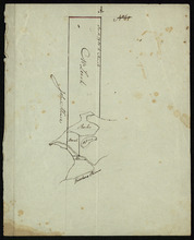
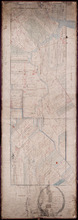
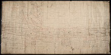
Part of Lot 37
Description: Plan of part of Lot 37 (No. 13). Property of Mr. Leech.[?] The map shows a parcel of land on the north side of the Hillsborough River in Lot 37. It gives the names of two residents. The map shows the… more
Province: Prince Edward Island
Type: cadastral maps
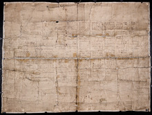
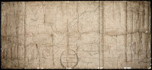
The Original Plan of Charlottetown Lots, No.1.
Description: Early plan of Charlottetown entitled "The Original Plan of Charlottetown Lots, No.1." Shows town lots, houses, windmill, battery, gallows, and the names of residents. Also includes code… more
Province: Prince Edward Island
Type: cadastral maps
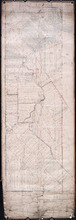
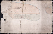
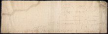
Plan of Part of Lot No. 23
Description: Plan of the northern part of Lot 23 (No.62). Hodgson Estate. Shows names of residents and acreage, Gulf of St. Lawrnce, creeks, rivers, and roads. Color code indicates free and leased land.
Province: Prince Edward Island
Type: cadastral maps
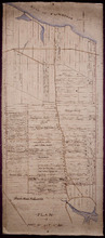
Plan of the Estate of D.S. Rennie Esqr. on Lot No. 23 in Queens County Prince Edward Island: As…
Description: The map shows a southern portion of Lot 23 divided into numbered parcels of land with the names of residents and their acreage amounts. Some parcels are coloured green. The map also shows the land… more
Province: Prince Edward Island
Type: cadastral maps
Date Created: 1863
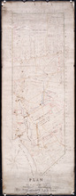
Plan of Township No. 23
Description: Plan of Lot 23. Shows the estates of Susan Rennie, David S. Rennie and Daniel Hodgson. Gives names of residents, acreage, and a few land conveyance references, rivers, gulfs, roads, towns, and a… more
Province: Prince Edward Island
Type: cadastral maps
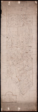
Plan of Part of Lot or Township No.23 in grenville Parish in Queens County, Prince Edward Island
Description: Plan of part of Lot 23 (No.61). The estate of David Rennie. Shows names of residents, acreage, and some land conveyance references, rivers, and roads.
Province: Prince Edward Island
Type: cadastral maps
Date Created: 1864-05
Plan Shewing the situation of the respective Fishing Establishments, Fronting Harris or Rustico Bay…
Description: Plan of part of Lot 24. Shows situation of the fishing establishments fronting Harris or Rustico Bay. From actual survey. The map shows the Harbours Mouth and Robinsons Island.
Province: Prince Edward Island
Type: cadastral maps
Date Created: 1869-09-02
A Plan of Part of Lot No. XXVII Situat in P.E.I. the Property of J. Cambridge Esq. from an Actual…
Description: Plan of part of Lot 27 (No.74). The property of J. Cambridge. Shows names of residents and acreage, Carlton Cove and a compass. Plan is one of those referred to in the Deed from Sir Edward, William… more
Province: Prince Edward Island
Type: cadastral maps
Date Created: 1828-08
Plan of the Western Moriety of Township No. 29: The Estate of The honorable Lady Fane
Description: Plan of the western moiety of Lot 29 (No.78). The estate of the Hon. Lady Fane. Shows names of residents, acreage, and a few land conveyance references, bodies of water such as the Gulf of St.… more
Province: Prince Edward Island
Type: cadastral maps
A Plan of the Western Moriety of Township Number 29: The property of Colonel The Hon. H.S. Fane…
Description: Plan of the western moiety of Lot 29 (No.81). Property of Colonel the Hon. H.S. Fane. Shows names of residents, acreage, and roads. Signed by Owen Curtis, Land Surveyor.
Province: Prince Edward Island
Type: cadastral maps

Map of Prince Edward Island in the Gulf of St. Lawrence: for McGregor's British America
Publisher: Ballantyne and Company
Province: Prince Edward Island
Type: cadastral maps, topographic maps
Date Created: 1832
Plan of the Northern Moiety of Lot or Township No. 48 in Prince Edward Island, Copied from the Plan…
Description: Plan of the northern moiety of Lot 48 (No.129). Shows the property of Miss Frances Crooke, R.G. Cuninghame, Theo. Desbrisay, and the Misses Lawton. The map shows lots, residents, roads, and bodies of… more
Province: Prince Edward Island
Type: cadastral maps
Date Created: 1836
Plan of Township No. 50 The Estate of the Misses[?] Fanning, Prince Edward Island: From actual…
Description: Plan of Lot 50. Fanning Estate. The map shows lots, residents, bodies of water and roads.
Province: Prince Edward Island
Type: cadastral maps
Plan of Lot 57
Description: Plan of Lot 57 (No.2) showing the lot divided into quarters. Also shows Refugee Share drawn for in Council, 12 February, 1784.
Province: Prince Edward Island
Type: cadastral maps
Date Created: 1784-02-12
A Plan of the undisposed of Parts of Lot No. 57: in Queens County in Prince Edward Island
Description: A plan of the undisposed of parts of Lot 57. Surveyed by Rod'k Campbell. The map shows parcels of land with names of owners or occupants and their corresponding acreage amounts handwritten in… more
Province: Prince Edward Island
Type: cadastral maps
Date Created: 1860

Plan of Lot Seventeen: Prince Co., P.E.I.
Description: The map shows lot 17 along with two smaller maps of lot 17 and 23. The map includes landowners and acreage, railroads and stations, roads, districts, creeks, rivers, bays, marshes, brooks, coves,… more
Publisher: J. H. Meacham & company
Province: Prince Edward Island
Type: cadastral maps
Date Issued (Source): 1880
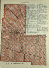
Lot No. 67: Queens County
Description: The map shows lot 67 in Queens county.Shown are roads, railroads, landowners, acreage, and Emerald Junction.
Publisher: Cummins Map Co.
Province: Prince Edward Island
Type: cadastral maps
Date Issued (Source): 1927

Plan of Lot Twenty One & Twenty: Queens Co., P.E.I.
Description: The map shows lots 21 and 20 (coloured in pink) in Queens county that border Prince county. The map names roads, landowners and acreage, creeks, gulfs, rivers, coves, fishing stations, post offices,… more
Publisher: J. H. Meacham & company
Province: Prince Edward Island
Type: cadastral maps
Date Issued (Source): 1880
Lot 20 and 21: Queens County
Description: The map shows lots 20 and 21 in Queens county. Shown are the Gulf of St. Lawrence, New London River and Bay, capes, ponds, rivers, landowners, acreage, and roads.
Publisher: Cummins Map Co.
Province: Prince Edward Island
Type: cadastral maps
Date Issued (Source): 1927
Lots 22 and 23: Queens County
Description: The map shows lots 22 and 23 in Queens county. Shown are rivers, roads, railroads, landowners, acreage, New London bay and the Gulf of St. Lawrence.
Publisher: Cummins Map Co.
Province: Prince Edward Island
Type: cadastral maps
Date Issued (Source): 1927

Victoria, Lot 29; Map of Lennox Island
Description: The page displays map of Victoria in Lot 29. Shown are roads and streets, a harbour, wharfs, landowners, post offices, buildings and school houses. Compass. The page also displays a map of Lennox… more
Publisher: J. H. Meacham & company
Province: Prince Edward Island
Type: cadastral maps
Date Issued (Source): 1880
Lot 24: Queens County
Description: The map shows lot 24 in Queens county. Shown are the Gulf of St. Lawrence, Rustico Bay and Harbour, river, cape, roads, landowners, and acreage.
Publisher: Cummins Map Co.
Province: Prince Edward Island
Type: cadastral maps
Date Issued (Source): 1927
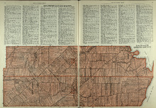
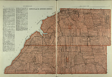
Plan of Lots 22 & 23 : Queens Co., P.E.I.
Description: The map shows lots 22 and 23 in Queens county. The map names roads, landowners and acreage, churches, halls, post offices, railroads, rivers, bays, and guls. Graphic compass.
Publisher: J. H. Meacham & company
Province: Prince Edward Island
Type: cadastral maps
Date Issued (Source): 1880
Lots 29 and 30: Queens County
Description: The map shows lots 29 and 30 in Queens county. Shown are roads, landowners, acreage, the Northumberland Strait, Westmoreland Harbour, and Sable River.
Publisher: Cummins Map Co.
Province: Prince Edward Island
Type: cadastral maps
Date Issued (Source): 1927
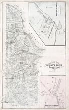
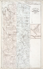
Plan of Lot Twenty Four: Queens Co., P.E.I.
Description: The map shows lot 24 in Queens county. Shown are rivers, gulfs, capes harbours, wharfs, lighthouses, fishing stages and holes, seaside hotels and bath houses, churches, crosses, post offices, roads,… more
Publisher: J. H. Meacham & company
Province: Prince Edward Island
Type: cadastral maps
Date Issued (Source): 1880
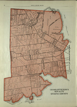
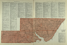
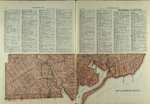
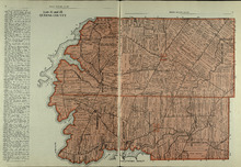
Charlottetown Royalty: Queens County
Description: The map shows the City of Charlottetown in Queens county. Shown are the Hillsborough and York Rivers. farms, landowners, acreage, roads, and railroads.
Publisher: Cummins Map Co.
Province: Prince Edward Island
Type: cadastral maps
Date Issued (Source): 1927
Lots 31 and 32: Queens County
Description: The map shows lots 31 and 32 in Queens county. Shown are rivers, landowners, acreage, roads, and railroads
Publisher: Cummins Map Co.
Province: Prince Edward Island
Type: cadastral maps
Date Issued (Source): 1927