Displaying 109 - 162 of 845
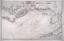
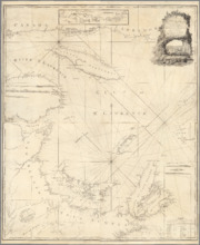
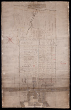
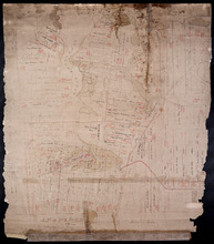
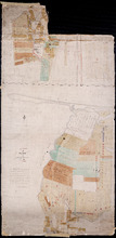
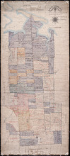
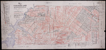
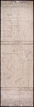
Hillsborough Bay
Description: Paper map in frame. Nautical chart originally published in 1842 and corrected and reissued many times. Large corrections in 1860, 1868, 1869, 1881. Relief is described pictorially, with hachures,… more
Publisher: Office of the Admiralty
Province: Prince Edward Island
Type: nautical charts
Date Issued: 1929
Date Created: 1842
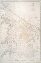
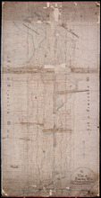
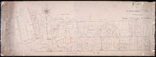
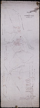
Richmond Bay: 1845
Description: Paper map in frame. Nautical chart originally published in 1845. Relief is described pictorially, with hachures, stippling and soundings. Bays, capes, heads, harbours, islands, lakes, ports, points,… more
Publisher: Hydrographic Office of the Admiralty
Province: Prince Edward Island
Type: nautical charts
Date Issued: 1850
Date Created: 1845
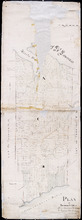
Plan of Île Saint-Jean: The Island of Saint John
Description: Plan of Ile Saint-Jean / the Island of Saint John. The map shows Prince Edward Island and a portion of the mainland. It identifies settlements, bays, harbours, rivers and islands. Sandy areas are… more
Province: Prince Edward Island
Type: topographic maps
Date Created: 1760
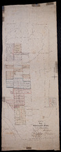
Plan Showing the Situation of Joseph Hammil's Farm on Lot No. 2. Containing Thirty acres on…
Description: Plan of part of Lot 2 showing Joseph Hammill's Farm containing 30 acres. The map shows Joseph Hammill's 30-acre parcel shaded in a greenish colour. It also shows the adjacent parcel of John… more
Province: PE
Type: cadastral maps
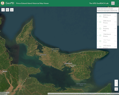
GeoPEI: Prince Edward Island Historical Map Viewer
Description: GeoPEI is a web portal developed by Dr. Josh MacFadyen and students in the GeoREACH Lab. Its purpose is to share maps, atlases, aerial photos, and geospatial data in an online map (aka. a webmap)… more
Publisher: UPEI GeoREACH Lab
Province: Prince Edward Island
Type: aerial photographs, cadastral maps
Date Created: 2024

IslandImagined - Digital Map Collection
Description: The Island Imagined is an online collection of historic maps of Prince Edward Island. The collection features maps, atlases, books, images, and documents from the Prince Edward Island Public Archives… more
Province: Prince Edward Island
Type: maps
A New Chart of the Gulf of St. Lawrence Compiled from the Original Drawings of Actual Surveys
Description: The most accurate chart of the Gulf of St. Lawrence in 1790, especially its depiction of Cape Breton Island. "The Most Detailed Chart of the St. Lawrence River to Date Fine example of Thomas… more
Publisher: William Faden
Province: Prince Edward Island, Nova Scotia, New Brunswick, Quebec
Type: nautical charts
Date Created: 1790
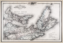
New Railway and Postal Map of the Dominion of Canada, Sheet No. 2
Description: Framed map shows the post offices, money order offices, P.O. saving offices, telegraph sections, ports of entry, railways and the distance between towns over post roads of the time. Prince Edward… more
Province: Prince Edward Island
Type: geological maps
Date Created: 1880
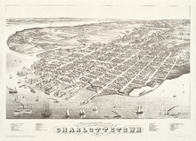
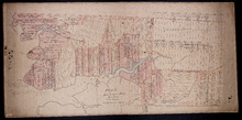
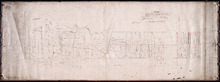
Panoramic view of Charlottetown, Prince Edward Island: 1878
Description: Panoramic, bird's eye view of Charlottetown from the harbour. Ships of various kinds, including sail and steam-powered, pictured in the foreground. View shows a busy, industrial waterfront with… more
Publisher: Prince Edward Island Museum and Hertiage Foundation
Province: Prince Edward Island
Type: bird's-eye views
Date Issued: 1983
Date Created: 1878
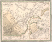
Canada East formerly Lower Canada
Description: Includes Quebec and Maritimes. Colour by region - primarily beige, yellow, green (compared to other versions of this map, the colours are muted). Inset map includes numbered counties for New… more
Publisher: Mitchell, S. Augustus, S. Augustus Mitchell
Province: Prince Edward Island
Date Created: 1846
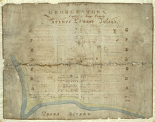
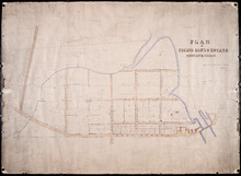
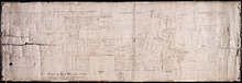
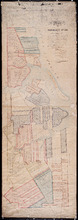
Plan of George-Town: Capital of Kings County, Prince Edward Island
Description: A hand-drawn map of Georgetown, PEI that includes the layout of the town including Kent Square, the ranges, house lots, water lots, and buildings. Three Rivers borders the town.
Province: Prince Edward Island
Date Created: 1835
Plan of the Estate of the Hon. Spencer Cecil Brabazon Ponsonby Fane Situate on Lot or Township No.…
Description: Plan of Lot 53 showing the estate of the Hon. Spencer Cecil Brabazon Ponsonby Fane. Copied by R.T. Weeks. Shows names and acreage of some residents, roads, and rivers such as Morell.
Province: Prince Edward Island
Type: cadastral maps

Plan of Lot or Township No. 53, shewing the positions of the respective boundaries thereof. Those…
Description: Plan of Lot 53 showing the position of the boundaries of the Melville, Selkirk and Westmoreland Estates (No.5). Shows names and acreage of a few residents, bodies of water such as rivers (Brudnell),… more
Province: Prince Edward Island
Type: cadastral maps

Royalty of Georgetown
Description: Plan of Lot 53 showing the estate of Lady Westmoreland. Shows names of residents and acreage, roads, and bodies of water such as rivers (Montague). Also shows the division line between the estate of… more
Province: Prince Edward Island
Type: cadastral maps
Plan Township No. 53. comprising parts of the Melville, Selkirk, and Fane Estates. Compiled and…
Description: Plan of Lot 53 comprising parts of the Melville, Selkirk and Fane Estates (No.144). Shows names, acreage, and land conveyance references for some residents, bodies of water such as rivers, and… more
Province: Prince Edward Island
Type: cadastral maps
Plan of Pierce Gaul's Estate Montague-Bridge
Description: Plan of Pierce Gaul's Estate, Montague Bridge, Lot No.52. The map shows the Montague River, streets, and buildings. more
Province: Prince Edward Island
Type: cadastral maps
Date Created: 1877-05

Plan of Lot or Township No. 51 in Kings County P. E. Island
Description: Plan of Lot 51 (No.139) Colour code shows freehold and unsold portions. Sir Graham Montgomery Estate. Shows names, acreage, and land conveyance references of some residents, and roads.
Province: Prince Edward Island
Type: cadastral maps
Plan of Township No. 50, the Property of Maria Susanna Matilda Fanning
Description: Plan of Lot 50, the property of Maria Susanna Matilda Fanning. Shows names of residents, acreage, and land conveyance references, bodies of water such as rivers (Vernon), bays (Pownal), and roads.… more
Province: Prince Edward Island
Type: cadastral maps

Plan of certain tracts of land at or near Orwell according to registered deeds, and two surveys…
Description: Plan of part of Lot 50. Clark's Corner, Orwell. Shows certain tracts of land at or near Orwell according to registered deeds and two surveys. Rough copy included. more
Province: Prince Edward Island
Type: cadastral maps

Plan of Part of Township No. 49. Bedford Parish. Queens County. P. E. Island.
Description: Plan of part of Lot 49 (No.135). One of the plans referred to in the deed from Sir Edward, William, and Laura Cunard to the Commissioner of Public Lands, July 13, 1866. The portion of land intended… more
Province: Prince Edward Island
Type: cadastral maps
Date Created: 1850
Plan of part of Lot 50
Description: Plan of part of Lot 50 (No.13). Area east of the Murray Harbour Road, north of the Dundee Road, and south of Georgetown Road. Shows names of residents.
Province: Prince Edward Island
Type: cadastral maps

Plan of Township Number 49. Shewing "Cunard" portion borderd. yellow. "Loan Act…
Description: Plan of Lot 49 showing Cunard portion bordered yellow, Loan Act Land bordered green, and remainder of Township (No.134). Copied from Meacham's Atlas by Owen Curtis. Shows names of residents,… more
Province: Prince Edward Island
Type: cadastral maps
Date Created: 1883-08
Plan of Lot 48 east of Fullerton's Creek
Description: Plan of that part of Lot 48 east of Fullerton's Creek. Shows names of residents and acreage. (No.13 in Plan Book) (Also, No.924) more
Province: Prince Edward Island
Type: cadastral maps
Date Created: 1874-01
Lot 45 (No.122)
Description: Plan of the northeastern part of Lot 45 (No.122). Shows names of residents and acreage and a nautical compass.
Province: Prince Edward Island
Type: cadastral maps
Plan of Township No. 44. Corrected from Surveys by Owen Curtis, J. C. Underhay and others. By Thos…
Description: Plan of Lot 44 (No.118) corrected by Thomas MacKinlay from surveys by Owen Curtis, J.C. Underhay and others. Cunard Estate. Shows some residents' names, acreage, and land conveyance references,… more
Province: Prince Edward Island
Type: cadastral maps
Date Created: 1887-09
Plan of Township No. 44.
Description: Plan of Lot 44 (No.120). Cunard Estate. Shows names and acreage of some residents, bodies of water such as rivers and gulfs, roads, and a mills (MacGowans).
Province: Prince Edward Island
Type: cadastral maps
A Plan of Lot or Township No. 43, Comprising the Haviland, Townsend, and Worrell Estates. Compiled…
Description: Plan of Lot 43 (No.116) comprising the Haviland, Townshend, and Worrell Estates. Completed from the surveys of J. Ball and J.C. Underhay by Owen Curtis. Shows names of residents, acreage, and land… more
Province: Prince Edward Island
Type: cadastral maps
Date Created: 1876-08

Plan of Lot 42 (No.112)
Description: Plan of Lot 42 (No.112). Shows names and acreage of some residents, bodies of water, and roads.
Province: Prince Edward Island
Type: cadastral maps

Pla of Lot or Township No. 42
Description: Plan of Lot 42 (No.113). Worrell Estate. Shows names of residents, acreage, and land conveyance references.
Province: Prince Edward Island
Type: cadastral maps
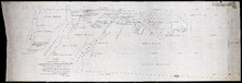
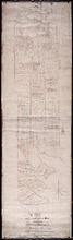
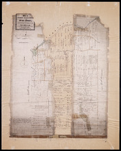
A Map and Survey of Part of Township Number Thirtyfive south side of the Hillsborough river, by…
Description: A map and survey of part of Lot 35, south side of the Hillsborough River. Shows names of residents, acreage, and land conveyance references, bodies of water such as rivers, and raods.
Province: Prince Edward Island
Type: cadastral maps
Date Created: 1887-03

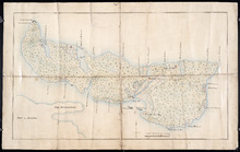
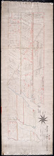
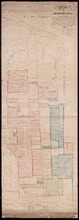
Plan of Lot 39
Description: Plan of Lot 39. Shows names of residents and acreage, bodies of water such as rivers, and bays, and division lines.
Province: Prince Edward Island
Type: cadastral maps
Date Created: 1857-07-01
Plan of Lot or Township No. 38: Compiled from the Survey of Jos.h Ball by O. Curtis, Land Office…
Description: Plan of Lot 38 (No.102). Shows names of residents, acreage, and some land conveyance references, bodies of water such as bays, rivers, ponds, gulfs, and harbours, roads, and a nautical compass.
Province: Prince Edward Island
Type: cadastral maps
Date Created: 1876-08

Plan of Lot Thirty Seven: Queens Co., P.E.I.
Description: Map of Lot 37 and part of Lot 38. Map is from Meacham's 1880 PEI Historical Atlas. A few land conveyance references have been added in red ink. The map shows bodies of water such as rivers,… more
Province: Prince Edward Island
Type: cadastral maps
Date Created: 1880
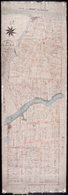
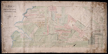
Plan of Fort Augustus and Monaghan Settlement in Township Number 36, in Prince Edward Island, the…
Description: Plan of Fort Augustus and Monaghan Settlement in Lot 36, the property of the Rev. John McDonald. Shows names of residents and acreage, bodies of water such as rivers (Hillsborough), ponds, roads, and… more
Province: Prince Edward Island
Type: cadastral maps
Date Created: 1840
Plan of Township No. 36 Comprising the Estates of Helen Jane MacDonald, Rev. J. A. S. MacDonald and…
Description: Plan of Lot 36 (No.100) comprising the Estates of Helen Jane MacDonald, Rev. J.A.S. MacDonald, and W.C. MacDonald. Shows names of residents, acreage, and land conveyance references, bodies of water… more
Province: Prince Edward Island
Type: cadastral maps
A Plan of part of Township No. 36
Description: A plan of the estate of the late Hon. Donald McDonald comprising part of Lots 35 and 36 divided and apportioned into six shares by Messrs. Aldous, Cundall, and Haythorne under power of an agreement… more
Province: Prince Edward Island
Type: cadastral maps
Date Created: 1865-02-03
A Plan of Township No. 34, The Property of Sir Graham Montgomery & Brothers Situate in Queens…
Description: Plan of Lot 34 (No.89). The property of Sir Graham Montgomery & Brothers. Shows names of residents and acreage, bodies of water such as rivers, and bays, roads, and a nautical compass.
Province: Prince Edward Island
Type: cadastral maps
Date Created: 1850-03-19
Plan of Township No,, 34 in Queens County in P. E. Island. The Property of Messrs,, Montgomeries,…
Description: Plan of Lot 34. Property of Messrs. Montgomery. Shows names of residents and acreage. Plan handed in to Registry Office by Aemeas McDonald. The map also shows bodies of water, bays, rivers, ponds,… more
Province: Prince Edward Island
Type: cadastral maps
Date Created: 1853-08
Plan "B" part of Township No. 33. as divided amongst the Children of the late Alfred…
Description: Plan of part of Lot 33 as divided amongst the children of the late Alfred Winsloe. Plan B. (No.87). The map also shows Rustico and Covhead Bays, along with Brackley Point, Union, Malpeque, and… more
Province: Prince Edward Island
Type: cadastral maps
Date Created: 1872-06-11
Plan of Township No. 33 In Prince Edward Island. Part of the Estate of the late John Hodges Winslow…
Description: Plan of Lot 33 (No.88). Part of the estate of the late John Hodges Winslow. Copied from the Original Plan by Thos. MacKinlay, April 23, 1847. Shows names of residents, acreage, and land conveyance… more
Province: Prince Edward Island
Type: cadastral maps
Date Created: 1847-04-23
Plan of Township No. 33. in Prince Edward Island.: referred to in the Deed of Partition [...]
Description: Plan of Lot 33 referred to in the Deed of Partition between Alfred Winsloe, Henry Winsloe, Sydney T. Evans and wife, and Anne Winsloe, March 13, 1863. Shows names of residents and acreage, bodies of… more
Province: Prince Edward Island
Type: cadastral maps
Date Created: 1863-03-13
Plan of Lot 32 (No.86).: Cunard Estate.
Description: Plan of Lot 32 (No.86). Cunard Estate. Shows names of residents, acreage, and some land conveyance references, bodies of water such as creeks and rivers, and roads. Copied by Owen Curtis.
Province: Prince Edward Island
Type: cadastral maps
Date Created: 1876-07

Plan of Township No. 32: compiled from the proprietors plans and Meacham's Atlas and from the…
Description: The map shows Lot 32 divided into parcels of land with names of residents, acreage amounts and land conveyance references. Areas drawn in black indicate government land; areas in red indicate… more
Province: Prince Edward Island
Type: cadastral maps
Date Created: 1919-01

Plan of Township No. 32 situate in the Parish of Charlotte, Queens County, P. E. Island: Scale 20…
Description: Plan of Lot 32 (No.85). One of the plans referred to in the Deed from Sir Edward, William, and Laura Cunard to the Commissioner of Public Lands, July 13, 1866. Shows names of residents, acreage, and… more
Province: Prince Edward Island
Type: cadastral maps
Date Created: 1849
Plan of Township No. 31 in Prince Edward Island
Description: Plan of Lot 31 from H.J. Cundall, one of the Trustees of the Wm. Douse Estate (Death of Wm. Douse in 1864). Shows names of residents, acreages, and some land conveyance references, bodies of water… more
Province: Prince Edward Island
Type: cadastral maps
Plan of Township No. 31: compiled from the proprietors plans and Meacham's Atlas and from the…
Description: Plan of Lot 31 compiled from the Proprietors' plans and Meacham's Atlas and from the descriptions in leases and registered deeds, with additions and corrections from various surveys made… more
Province: Prince Edward Island
Type: cadastral maps
Date Created: 1917-12

Titles to Lot 31
Description: Plan of Lot 31 (No.84). Douse Estate. Shows names of some residents, some acreage, some land conveyance references, roads, and a nautical compass.
Province: Prince Edward Island
Type: cadastral maps

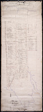
Plan of the East Moriety of Lot or Township No 29: part of the Estate of Lord Vicount Melville…
Description: Plan of the east moiety of Lot 29 (No.79). Part of the estate of Lord Viscount Melville. Shows names of residents, acreage, and a few land conveyance references, bodies of water such as the… more
Province: Prince Edward Island
Type: cadastral maps
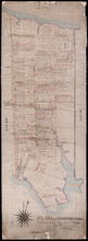
Plan of Township No. 26: Embracing the Thomson Holland and Stephens Estates
Description: Plan of Lot 26 embracing the Thomson, Holland, and Stephens Estates. Shows names of residents, acreage, and land conveyance references, bodies of water such as river, cove, and pond, roads, and a… more
Province: Prince Edward Island
Type: cadastral maps
Plan of the North Moriety of a Township No. 26 the Property if the Messrs Thompson of Belfast…
Description: Plan of the North Moiety of Lot 26, the property of the Messrs. Thompson of Belfast Ireland. Shows names of residents, acreage, and a few land conveyance references, bodies of water such as Bedeque… more
Province: Prince Edward Island
Type: cadastral maps
Date Created: 1875-11-05
Plan "A" Part of Township No. 24: as divided amongst the children of the late Alfred…
Description: Plan "A" part of Lot 24 as divided amongst the children of the late Alfred Winsloe (No.64). Shows names of residents and acreage, bodies of water such as rivers, creeks, roads, and a… more
Province: Prince Edward Island
Type: cadastral maps
Date Created: 1872-06-11
Plan of Lot 24 (No.66): Part of the estate of John Hodges Winsloe
Description: Plan of Lot 24 (No.66). Part of the estate of John Hodges Winsloe. Shows names of residents, acreage, and a few land conveyance references, bodies of water such as Gulf of St. Laurence, rivers, roads… more
Province: Prince Edward Island
Type: cadastral maps
Date Created: 1847
This is the Plan of Township No. 24 in Prince Edward Island
Description: Plan of Lot 24 showing the division of the Winsloe Estate. Shows names of residents and acreage, bodies of water such as gulfs, bays, creeks, rivers, sand hills, Rustico or Peter's Island and… more
Province: Prince Edward Island
Type: cadastral maps
Date Created: 1863-03-13
Plan of Township No. 24 in Prince Edward Island
Description: Plan of Lot 24. Smith Estate. Mainly outline but shows a few residents and acreage, bodies of water such as rivers, gulfs, bays and creeks, roads, sand hills, and Rustico or Peter's Island. more
Province: Prince Edward Island
Type: cadastral maps