Displaying 1 - 61 of 61

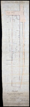
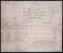
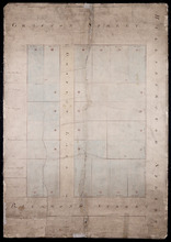
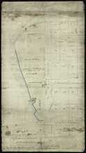
Common Lot No 21 as divided into Building Lots
Description: Plan of Common Lot No.21. Charlottetown as divided into building lots. (No.380) The map shows lots, acreage and roads/streets.
Province: Prince Edward Island
Type: cadastral maps
Date Created: 1872-08
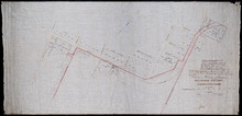
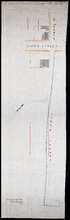
P.E.Island Railway: Charlottetown
Description: Prince Edward Island Railway. Charlottetown. Appropriations into Charlottetown Station. The map shows roads, streets, lots, and buildings.
Province: Prince Edward Island
Type: plans
Date Created: 1871

A plan of Charlottetown, the capital of the Island delineated by order of Walter Patterson,…
Description: A plan of Charlottetown, the capital of the Island delineated by order of Walter Patterson, Governor of the said Island (No.2). Includes Charlottetown Common and Royalty. Shows names of some… more
Province: Prince Edward Island
Type: cadastral maps

Plan of the Royalty of Charlottetown: from a survey taken in the year 1831 by Order of His…
Description: "Plan of the Royalty of Charlottetown from a survey taken in the year 1831 by Order of His Excellency Lieutenant Governor Ready." Shows Royalty Lot numbers, and acreage. (No.67) more
Province: Prince Edward Island
Type: cadastral maps
Date Created: 1831

Plan Shewing lands in Charlottetown Appropriated fro Railway purposes : The Figures 67 &c.…
Description: Plan showing lands in Charlottetown appropriated for Railway purposes. The map shows lots, residents, streets, and wharfs.
Province: Prince Edward Island
Type: cadastral maps
Plan Shewing Lands in the Common and Royalty of Charlottetown appropriated for Railway purposes.
Description: Plan showing land in the Common and Royalty of Charlottetown appropriated for Railway purposes. The map shows lots, acreage, roads, cities and towns.
Province: Prince Edward Island
Type: cadastral maps

Plan of Charlotte Town Shewing the true position of the Streets and the encroachments thereon.…
Description: The map shows the street grid, numbered town lots and public squares of Charlottetown. It shows some buildings and some of the roads leading to/from the town.
Province: Prince Edward Island
Type: plans
Date Created: 1833
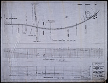
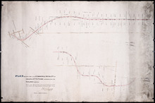
Plan of Proposed Railway Crossing North River to Mount Edward Roads
Description: Plan of proposed Railway crossing North River to Mount Edward Road. Department of Public Works and Highways, Province of Prince Edward Island. Plan shows 3 drawings consisting of the Railway &… more
Province: Prince Edward Island
Type: cadastral maps, transportation maps
Date Created: 1949
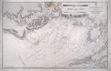
Hillsborough Bay
Description: Paper map in frame. Nautical chart originally published in 1842 and corrected and reissued many times. Large corrections in 1860, 1868, 1869, 1881. Relief is described pictorially, with hachures,… more
Publisher: Office of the Admiralty
Province: Prince Edward Island
Type: nautical charts
Date Issued: 1929
Date Created: 1842
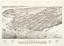
Panoramic view of Charlottetown, Prince Edward Island: 1878
Description: Panoramic, bird's eye view of Charlottetown from the harbour. Ships of various kinds, including sail and steam-powered, pictured in the foreground. View shows a busy, industrial waterfront with… more
Publisher: Prince Edward Island Museum and Hertiage Foundation
Province: Prince Edward Island
Type: bird's-eye views
Date Issued: 1983
Date Created: 1878

Plan of Township No. 32: compiled from the proprietors plans and Meacham's Atlas and from the…
Description: The map shows Lot 32 divided into parcels of land with names of residents, acreage amounts and land conveyance references. Areas drawn in black indicate government land; areas in red indicate… more
Province: Prince Edward Island
Type: cadastral maps
Date Created: 1919-01

Plan of Town Lots No.74 and No.75 in the 4th Hundred of Town Lots in the city of Charlottetown with…
Description: Plan of Town Lots No.74 and No.75 in the 4th Hundred of Town Lots in the city of Charlottetown with the respective subdivisions delineated thereon. (No.64) Shown are lots and residents.
Province: Prince Edward Island
Type: cadastral maps
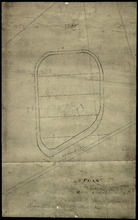
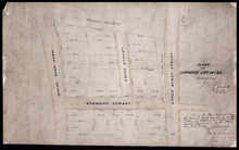
Plan of Race Course Charlottetown Royalty
Description: Plan of the Old Race Course in Charlottetown Royalty. (No.21). Shows lots and residents.
Province: Prince Edward Island
Type: cadastral maps
Plan of part of Town Lots Nos. 54 and 55, and Nos. 91 and 92 in the 2nd Hundred of Town Lots in…
Description: Plan of part of Town Lots Nos. 54 and 55, and Nos. 91 and 92 in the 2nd Hundred of Town Lots in Charlottetown agreeably to the possession of the Misses Stewart according to the original survey of the… more
Province: Prince Edward Island
Type: cadastral maps
Date Created: 1860-07-25

Plan of Township No. 32: compiled from the proprietors plans and Meacham's Atlas and from the…
Description: The map shows Lot 32 divided into parcels of land with names of residents, acreage amounts and land conveyance references. Areas drawn in black indicate government land; areas in red indicate… more
Province: Prince Edward Island
Type: cadastral maps
Date Created: 1919-01
Plan Shewing the Northern Boundary Line of the Victoria Park Roadway as Surveyed by Thomas W. May L…
Description: Plan showing the northern boundary line of the Victoria Park Roadway. This is the plan referred to in "The Victoria Park Roadway Act, 1896". Shown is the Charlottetown Harbour, Governor… more
Province: Prince Edward Island
Type: cadastral maps
Date Created: 1896

Plan Shewing the Eligible Situation of Acre Lots on the Estate of the Honble. J. C. Pope. in the…
Description: Plan showing the eligible situation of acre lots on the estate of Hon. J.C. Pope in the Royalty of the city of Charlottetown. Royalty Lots No.85, No.95 and No.97. (No.386)
Province: Prince Edward Island
Type: cadastral maps
Date Created: 1878
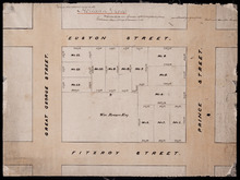
Holland Grove
Description: Plan of the block of land between Euston Street and Fitzroy Street and Prince Street and Great George Street known as Holland Grove. Town Lots 18-22 and 63-67 in the fifth hundred.
Province: Prince Edward Island
Type: cadastral maps
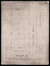
Plan A. Of 4 Pleasantly Situated Building Lots, fronting on Upper Prince Street, The property of…
Description: Plan "A" of four pleasantly situated lots fronting on Upper Prince Street, the property of the Hon. T.H. Haviland, Common Lot No.24. (No.60) more
Province: Prince Edward Island
Type: cadastral maps
Date Created: 1886

Plan of St. Avard's divided into Building Lots part of the Estate of the Honble. James C. Pope…
Description: Plan of St. Avards divided into building lots, part of the estate of the Hon. James C. Pope in the Royalty of Charlottetown. Royalty Lot No.13. Also shown are St. Peters Road, and Mt. Stewart Road.
Province: Prince Edward Island
Type: cadastral maps
Date Created: 1878

Plan showing the situation of part of the Estate of the late Owen Connolly Esq. in Charlottetown…
Description: Plan showing the situation of part of the Estate of the late Owen Connolly in Charlottetown Common and Royalty. Created by John Ball, surveyor, and copied by Thomas W. May. The map shows Malpeque… more
Province: Prince Edward Island
Type: cadastral maps
Date Created: 1921-01
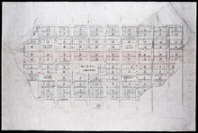
Plan of the city of Charlottetown
Description: Plan of the city of Charlottetown. Shows the location of the 1st to the 5th Hundred and the Town Lots situated thereon.
Province: Prince Edward Island
Type: cartograms map
Plan Shewing the situation of that part of Water Lot No. 7. at Charlottetown Sold to Henry Beer Esq.
Description: Plan showing the situation of that part of Water Lot No.7 at Charlottetown sold to Henry Beer. (No.26) (Also No.216 Queens County). The map shows streets such as Great George, Prince, Water, wharfs,… more
Province: Prince Edward Island
Type: cadastral maps
Date Created: 1881
Plan Shewing the situation of Water Lot No. 8, and that part of Water Lot No. 7 conveyed to Ronald…
Description: Plan showing the situation of Water Lot No.8 and that part of Water Lot No.7 conveyed to Ronald MacMillan. The map also shows streets such as Water street, Prince, lots, Ferry Wharf, and Hillsborough… more
Province: Prince Edward Island
Type: cadastral maps
Plan of part of Charlottetown showing Pownal Wharf and Lot No.5
Description: Plan of part of Charlottetown showing Pownal Wharf and part of Town Lot No.5 located in 1st Hund. Also shown are buildings and wharfs.
Province: Prince Edward Island
Date Created: 1868-08
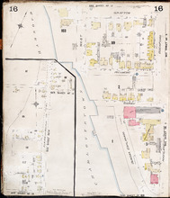
Charlottetown P.E.I.: July 1903
Description: This is Page 16 of 20 pages of fire insurance maps of Charlottetown. It was created in 1903 and revised to either 1910 or 1917. It contains two (2) maps, showing two (2) different areas of the city.… more
Publisher: Chas. E. Goad, Civil Engineer
Province: Prince Edward Island
Type: fire insurance maps
Date Created: 1903-07
Date Modified: 1910-08, 1917-07 (year and month uncertain)
Date Issued (Source): 1888
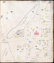
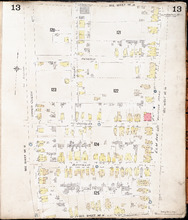
Charlottetown, P.E.I.: July, 1903
Description: This is Page 17 of 20 pages of fire insurance maps of Charlottetown. It was created in 1903 and revised to either 1910 or 1917. It shows an area bounded by Brighton Road and Euston Street to the… more
Publisher: Chas. E. Goad, Civil Engineer
Province: Prince Edward Island
Type: fire insurance maps
Date Created: 1903-07
Date Modified: 1910-08, 1917-07 (year and month uncertain)
Date Issued (Source): 1888
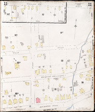
Charlottetown P.E.I.: July, 1903.
Description: This is Page 18 of 20 pages of fire insurance maps of Charlottetown. It was created in 1903 and revised to either 1910 or 1917. It shows the area from Euston Street to Grafton Street, between… more
Publisher: Chas. E. Goad, Civil Engineer
Province: Prince Edward Island
Type: fire insurance maps
Date Created: 1903-07
Date Modified: 1910-08, 1917-07 (year and month uncertain)
Date Issued (Source): 1888
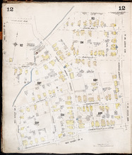
Charlottetown P.E.I.: July 1903
Description: This is Page 19 of 20 pages of fire insurance maps of Charlottetown. It was created in 1903 and revised to either 1910 or 1917. It shows the area from Grafton Street to Water Street, between Weymouth… more
Publisher: Chas. E. Goad, Civil Engineer
Province: Prince Edward Island
Type: fire insurance maps
Date Created: 1903-07
Date Modified: 1910-08, 1917-07 (year and month uncertain)
Date Issued (Source): 1888
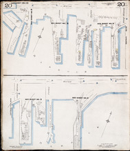
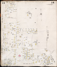
Charlottetown P.E.I.: July 1917. Reprinted.
Description: This is Page 20 of 20 pages of fire insurance maps of Charlottetown. It shows Water Street in two (2) sections that are intended to be continuous. The section at the top of the page shows Water… more
Publisher: Chas. E. Goad, Civil Engineer
Province: Prince Edward Island
Type: fire insurance maps
Date Created: 1917-07
Date Issued (Source): 1888

Plan of Building Lots in Common Lots Nos. 28 and 29 (Palmer Estate)
Description: Plan of building lots in Common Lots No.28 and No.29. The Palmer Estate. The map also shows streets such as Euston, Orlebar, lot numbers and acreage.
Province: Prince Edward Island
Type: cadastral maps
Date Created: 1913

Plan of Right of Way as on the Ground part of Town Lot No. 36 in the 4th Hund. Charlottetown.
Description: Plan of the Right of Way through Town Lot No.36 in the 4th Hundred in Charlottetown. (No.40). The map shows Kent Street and landowners.
Province: Prince Edward Island
Type: cadastral maps
Date Created: 1898-06
Plan Shewing the division of Pasture Lots Nos. 61, 62, 70 & 71 in the Royalty of Charlotte Town
Description: Plan showing the division of Pasture or Royalty Lots No.61, No.62, No.70 and No.71 in the Royalty of Charlottetown.
Province: Prince Edward Island
Plan of building lots on the west side of Hillsborough Street, Charlottetown
Description: Plan of building lots on the west side of Hillsborough Street between Grafton and Richmond Streets, Charlottetown. Town Lots No.58, No.59, No.60 and No.95, No.96, No.97 in the 2nd Hund.
Province: Prince Edward Island
Type: cartograms map
Plan of the subdivision of property owned by Mrs. John Longworth in the Commons of Charlottetown:…
Description: Plan of the subdivision of property owned by Mrs. John Longworth in the Commons of Charlottetown, Common Lot No.29. Plan made under the instructions of H.J. Palmer, Trustee for Mrs. John Longworth. (… more
Province: Prince Edward Island
Type: cadastral maps
Date Created: 1923-07-19
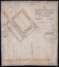
Part of Common Lot No. 22.
Description: Plan of part of Common Lot No.22, Charlottetown.
Province: Prince Edward Island
Type: cadastral maps
Date Created: 1886
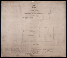
No. 3 Plan of a Tract of Land Appropriated by the Commissioners of the Water-works of Charlottetown
Description: Plan of a tract of land in Charlottetown Royalty appropriated by the Commissioners of the Water-works of Charlottetown. (No.3) (Also No.104). Also shown are landowners and acreage.
Province: Prince Edward Island
Type: cadastral maps
Plan Shewing the position of Common Lot No. 18: from actual survey by Joseph Ball
Description: Plan of the part of Charlottetown showing the position of Common Lot No. 18 on the west side of West Street. Gives names of residents on that side of the street. Shows numbered common lots in the… more
Province: Prince Edward Island
Type: cadastral maps
The Original Plan of Charlottetown Lots, No.1.
Description: Early plan of Charlottetown entitled "The Original Plan of Charlottetown Lots, No.1." Shows town lots, houses, windmill, battery, gallows, and the names of residents. Also includes code… more
Province: Prince Edward Island
Type: cadastral maps
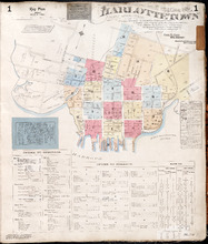
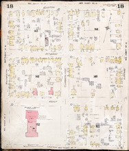
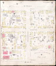
Charlottetown Prince Edward Island: Population: 12,500. July 1903
Description: This item, the first of 20 pages of fire insurance maps of Charlottetown, serves as the key plan for the other Charlottetown pages. It was created in 1903, revised to 1910 and revised again to 1917.… more
Publisher: Chas. E. Goad, Civil Engineer
Province: Prince Edward Island
Type: fire insurance maps
Date Created: 1903-07
Date Modified: 1910-08, 1917-07
Date Issued (Source): 1888
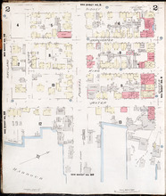
Charlottetown, Prince Edward Island: July 1917. Reprinted
Description: This is Page 2 of 20 pages of fire insurance maps of Charlottetown. It shows the area from Sidney Street to the waterfront, between Haviland and Queen streets. The map shows numbered city blocks and… more
Publisher: Chas. E. Goad, Civil Engineer
Province: Prince Edward Island
Type: fire insurance maps
Date Created: 1917-07
Date Issued (Source): 1888
Charlottetown, Prince Edward Island: July 1917. Reprinted
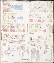
Description: This is Page 3 of 20 pages of fire insurance maps of Charlottetown. It shows the area from Sidney Street to the waterfront, between Queen and Prince streets. The map shows numbered city blocks and… more
Publisher: Chas. E. Goad, Civil Engineer
Province: Prince Edward Island
Type: fire insurance maps
Date Created: 1917-07
Date Issued (Source): 1888
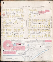
Charlottetown, P.E.I.: July 1903
Description: This is Page 4 of 20 pages of fire insurance maps of Charlottetown. It was created in 1903 and revised to either 1910 or 1917. The map shows the area from Sidney Street to the waterfront, between… more
Publisher: Chas. E. Goad, Civil Engineer
Province: Prince Edward Island
Type: fire insurance maps
Date Created: 1903-07
Date Modified: 1910-08, 1917-07 (year and month uncertain)
Date Issued (Source): 1888
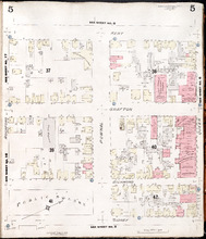
Charlottetown, P.E.I.: July 1917. Reprinted
Description: This is Page 5 of 20 pages of fire insurance maps of Charlottetown. It shows the area from Kent Street to Sidney Street, between Rochford and Queen streets. The map shows numbered city blocks and the… more
Publisher: Chas. E. Goad, Civil Engineer
Province: Prince Edward Island
Type: fire insurance maps
Date Created: 1917-07
Date Issued (Source): 1888
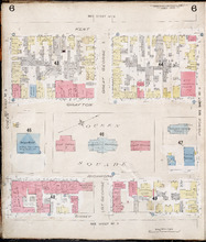
Charlottetown, P.E.I.: July 1903.
Description: This is Page 6 of 20 pages of fire insurance maps of Charlottetown. It was created in 1903 and revised to either 1910 or 1917. The map shows the area from Kent Street to Sidney Street, between Queen… more
Publisher: Chas. E. Goad, Civil Engineer
Province: Prince Edward Island
Type: fire insurance maps
Date Created: 1903-07
Date Modified: 1910-08, 1917-07 (year and month uncertain)
Date Issued (Source): 1888
Charlottetown, P.E.I.: July 1903.
Description: This is Page 7 of 20 pages of fire insurance maps of Charlottetown. It was created in 1903 and revised to either 1910 or 1917. The map shows the area from Kent Street to Sidney Street, between Prince… more
Publisher: Chas. E. Goad, Civil Engineer
Province: Prince Edward Island
Type: fire insurance maps
Date Created: 1903-07
Date Modified: 1910-08, 1917-07 (year and month uncertain)
Date Issued (Source): 1888
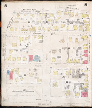
Charlottetown, P.E.I.: July 1903
Description: This is Page 8 of 20 pages of fire insurance maps of Charlottetown. It was created in 1903 and revised to either 1910 or 1917. It shows the area from Churchill Avenue and Chestnut Street to Kent… more
Publisher: Chas. E. Goad, Civil Engineer
Province: Prince Edward Island
Type: fire insurance maps
Date Created: 1903-07
Date Modified: 1910-08, 1917-07 (year and month uncertain)
Date Issued (Source): 1888
Charlottetown, P.E.I.: July 1903.
Description: This is Page 9 of 20 pages of fire insurance maps of Charlottetown. It was created in 1903 and revised to either 1910 or 1917. It shows the area from Passmore Street to Kent Street, between Queen and… more
Publisher: Chas. E. Goad, Civil Engineer
Province: Prince Edward Island
Type: fire insurance maps
Date Created: 1903-07
Date Modified: 1910-08, 1917-07 (year and month uncertain)
Date Issued (Source): 1888
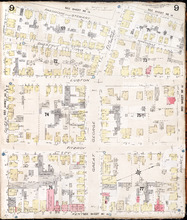
Charlottetown P.E.I.: July 1903
Description: This is Page 10 of 20 pages of fire insurance maps of Charlottetown. It was created in 1903 and revised to either 1910 or 1917. It shows the area from just north of Euston Street, south to Kent… more
Publisher: Chas. E. Goad, Civil Engineer
Province: Prince Edward Island
Type: fire insurance maps
Date Created: 1903-07
Date Modified: 1910-08, 1917-07 (year and month uncertain)
Date Issued (Source): 1888
Charlottetown P.E.I.: July 1917. Reprinted
Description: This item, Page 11 of 20 pages of fire insurance plans of Charlottetown, consists of two (2) maps. The main map shows the area from Green Street to Brighton Road, between Greenfield Avenue (Second)… more
Publisher: Chas. E. Goad, Civil Engineer
Province: Prince Edward Island
Type: fire insurance maps
Date Created: 1917-07
Date Issued (Source): 1888
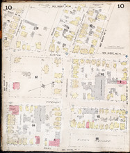
Charlottetown P.E.I.: July, 1903.
Description: This is Page 12 of 20 pages of fire insurance maps of Charlottetown. It was created in 1903 and revised to either 1910 or 1917. It shows the area from Douglas Street to Churchill Avenue and Chestnut… more
Publisher: Chas. E. Goad, Civil Engineer
Province: Prince Edward Island
Type: fire insurance maps
Date Created: 1903-07
Date Modified: 1910-08, 1917-07 (year and month uncertain)
Date Issued (Source): 1888
Charlottetown P.E.I.: July, 1903.
Description: This is Page 13 of 20 pages of fire insurance maps of Charlottetown. It was created in 1903 and revised to either 1910 or 1917. It shows the area bounded by Connolly Street in the north, Elm Avenue/… more
Publisher: Chas. E. Goad, Civil Engineer
Province: Prince Edward Island
Type: fire insurance maps
Date Created: 1903-07
Date Modified: 1910-08, 1917-07 (year and month uncertain)
Date Issued (Source): 1888
Charlottetown P.E.I.: July, 1903.
Description: This is Page 14 of 20 pages of fire insurance maps of Charlottetown. It was created in 1903 and revised to either 1910 or 1917. It shows the area from Allan (Allen) Street, in the north, to (… more
Publisher: Chas. E. Goad, Civil Engineer
Province: Prince Edward Island
Type: fire insurance maps
Date Created: 1903-07
Date Modified: 1910-08, 1917-07 (year and month uncertain)
Date Issued (Source): 1888
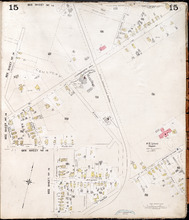
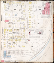
Charlottetown, P.E.I.: July, 1903.
Description: This is Page 15 of 20 pages of fire insurance maps of Charlottetown. It was created in 1903 and revised to either 1910 or 1917. The map shows part of the eastern portion of early twentieth-century… more
Publisher: Chas. E. Goad, Civil Engineer
Province: Prince Edward Island
Type: fire insurance maps
Date Created: 1903-07
Date Modified: 1910-08, 1917-07 (year and month uncertain)
Date Issued (Source): 1888
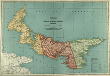
Province of Prince Edward Island, Canada: Cummins Map Co. Toronto
Description: The map shows all of Prince Edward Island and some of New Brunswick and Nova Scotia. Shown through a table of Counties are bays, roads, marshes, rapids, Indian Reserves, Lighthouses, depth of water,… more
Publisher: Cummins Map Co.
Province: Prince Edward Island
Type: cadastral maps
Date Issued (Source): 1927
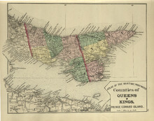
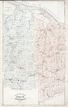
Counties of Queens and Kings: Prince Edward Island
Description: The map shows the counties of Queens and Kings in Prince Edward Island. Shown are bays, points, rivers, capes, coves, harbours, roads, railroads, cities, and towns.
Publisher: Roe Brothers
Province: Prince Edward Island
Type: geological maps
Date Issued (Source): 1878
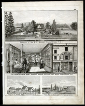
Property Sketches - Page 38
Description: Property sketches of the Residence of Hon. W. W. Sullivan, Charlottetown, P.E.I.; E.W. Taylor' Jewelry Store - interior and exterior, South Side Queen Square, Charlottetown, P.E.I.; The farms of… more
Publisher: J. H. Meacham & company
Province: Prince Edward Island
Type: image
Date Issued (Source): 1880
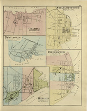
Chatham : Charlottetown : New Castle : City of Fredricton : Moncton: Northumberland Co. N.B..…
Description: The map shows Catham in the Northumberland county. New Brunswick. Shown are a river, wharf, streets, buildings, lots and a ferry crossing. The map shows Charlottetown in Queens county, Prince Edward… more
Publisher: Roe Brothers
Province: New Brunswick, Prince Edward Island
Type: geographical maps
Date Issued (Source): 1878
Plan of Lots 33 & 34: Queens Co., P.E.I.
Description: The map shows lots 33 (coloured in blue) & 34 (coloured in pink) in Queens county. The map shows roads, railroads and stations, landowners and acreage, farms, post offices, churches, hotels,… more
Publisher: J. H. Meacham & company
Province: Prince Edward Island
Type: cadastral maps
Date Issued (Source): 1880
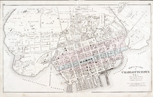
Map of the City of Charlottetown
Description: The map shows the city of Charlottetown. Shown are the wards, roads, landowners and acreage, asylums, ponds, rivers, houses, cemetery, estates, churches, lakes, parks, wharfs, and Charlottetown… more
Publisher: J. H. Meacham & company
Province: Prince Edward Island
Type: cadastral maps
Date Issued (Source): 1880
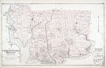
Plan of Charlottetown Royalty: Queens Co., P.E.I.
Description: The map shows the city of Charlottetown and a plan for lots. Shown are rivers, creeks, roads, railroad and stations, landowners and acreage, mills, park, bridge, college, farms, asylums, and a… more
Publisher: J. H. Meacham & company
Province: Prince Edward Island
Type: cadastral maps
Date Issued (Source): 1880