| Title Proper |
Atlas of Province of Prince Edward Island, Canada and the World
|
|---|---|
| Description |
Cummins devotes most of its opening pages to a detailing of the Island’s contribution to the First World War or “European War”. This event had forever changed many communities on the Island.
More positively, new industries such as silver fox farming are also highlighted as are the continuing growth of the potato and lobster industries which would both become increasingly important in the 20th century. |
| Access Condition |
This material is provided for research, education, and private use only.
|
| Type | |
| Physical Location |
Robertson Library, UPEI
|
| Contributors |
Cartographer: Cummins Map Co
|
| Date Issued |
1927
|
| Publisher |
Cummins Map Co.
|
| Extent |
140, lxxii p. : ill.
|
| Subject (Geographic) |
Atlas of Province of Prince Edward Island, Canada and the World
In this collection
Displaying 55 - 81 of 153
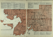
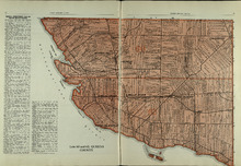
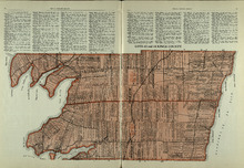
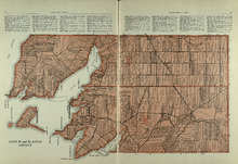
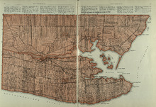
Lots 49 and 50: Queens County
Description: The map shows lots 49 and 50 in Queens county. Shown are bays, Governor Island, points, rivers, roads, railroads, landowners, and acreage.
Province: Prince Edward Island
Type: cadastral maps
Date Issued (Source): 1927
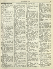
Rural Directory - Lots 49 and 50, Queens County
Description: A directory listing of residents of lots 49 and 50.
Province: Prince Edward Island
Type: text
Date Issued (Source): 1927
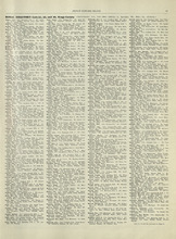
Rural Directory - Lots 57 and 58, Queens County
Description: A directory listing of residents of lots 57 and 58.
Province: Prince Edward Island
Type: text
Date Issued (Source): 1927
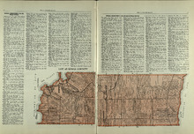
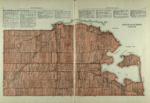
Lots 57 and 58: Queens County
Description: The map shows lots 57 and 58 in Queens county. Shown are Pinette Harbour, Northumberland Strait, Orwell Bay, rivers, roads, railroads, landowners,and acreage.
Province: Prince Edward Island
Type: cadastral maps
Date Issued (Source): 1927
Lots 60 and 62: Queens County
Description: The map shows lots 60 and 62 in Queens county. Shown are the Northumberland Strait, roads, railroads, harbour, points, landowners, and acreage.
Province: Prince Edward Island
Type: cadastral maps
Date Issued (Source): 1927
Rural Directory - Lots 60 and 62, Queens County
Description: A directory listing of residents of lots 60 and 62.
Province: Prince Edward Island
Type: text
Date Issued (Source): 1927
Rural Directory - Lots 35 and 36, Queens County
Description: A directory listing of residents of lots 35 and 36.
Province: Prince Edward Island
Type: text
Date Issued (Source): 1927
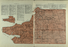
Lots 35 and 36: Queens County
Description: The map shows lots 35 and 36 in Queens County. Shown are Hillsborough River, Tracadie Bay, Gulf of St. Lawrence. Mill Cove, landowners, acreage, raods, and railroads.
Province: Prince Edward Island
Type: cadastral maps
Date Issued (Source): 1927
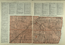
Lot 37, Queens County: Lot 38 Kings County
Description: The map shows lot 37 in Queens county and lot 38 in Kings county. Shown are the Gulf of St. Lawrence, Savage Harbour, landowners, acreage, roads, railroads, and rivers.
Province: Prince Edward Island
Type: cadastral maps
Date Issued (Source): 1927
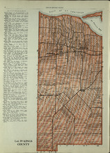
Lot 39: Kings County
Description: The map shows lot 39 in Kings county. Shown are the Gulf of St. Lawrence, St. Peters bay, landowners, acreage, roads, railroads, Stukeley Ponds, and sands hills.
Province: Prince Edward Island
Type: cadastral maps
Date Issued (Source): 1927
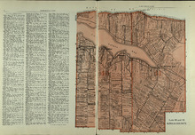
Lots 40 and 41: Kings County
Description: The map shows lots 40 and 41 in Kings county. Shown are the Gulf of St. Lawrence, St. Peters Bay, landowners, acreage, roads, and railroads.
Province: Prince Edward Island
Type: cadastral maps
Date Issued (Source): 1927
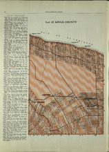
Lot 42: Kings County
Description: The map shows lot 42 in Kings county. Shown are the Gulf of St. Lawrence, points, landowners, acreage, roads, and railroads.
Province: Prince Edward Island
Type: cadastral maps
Date Issued (Source): 1927
Rural Directory - Lots 42 - 44, Kings County
Description: A directory listing of residents of lots 42, 43, and 44
Province: Prince Edward Island
Type: text
Date Issued (Source): 1927
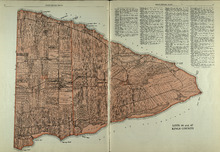
Lots 43 and 44 : Kings County
Description: The map shows lots 43 and 44 in Kings county. Shown are the Gulf of St. Lawrence, bays, points, rivers, landowners, acreage, roads, and railroads.
Province: Prince Edward Island
Type: cadastral maps
Date Issued (Source): 1927
Rural Directory - Lot 51, 52, and 66, Kings County
Description: A directory listing of residents of lot 51, 52, and 66
Province: Prince Edward Island
Type: text
Date Issued (Source): 1927
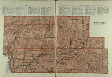
Lot 45: Kings County
Description: The map shows lot 45 in Kings county. Shown are the Gulf of St. Lawrence, Colville bay, landowners, acreage, roads, and railroads.
Province: Prince Edward Island
Type: cadastral maps
Date Issued (Source): 1927
Lots 46 and 47 : Kings County
Description: The map shows lots 46 and 47 in Kings county. Shown are the Gulf of St. Lawrence, points, rivers, coves, landowners, acreage, roads, railroads, lakes, and sand.
Province: Prince Edward Island
Type: cadastral maps
Date Issued (Source): 1927
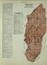
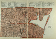
Georgetown Royalty: Kings County
Description: The map shows Georgetown Royalty in Kings county. Shown are landowners, acreage, Brudenell and Cardigan River, Albion Bay, roads, and railroads.
Province: Prince Edward Island
Type: cadastral maps
Date Issued (Source): 1927
Lots 51, 52, and 66: Kings County
Description: The map shows lots 51, 52, and 66 in Kings County. Shown are Brown Creek, Montague River, Landowners, acreage, roads, and railroads.
Province: Prince Edward Island
Type: cadastral maps
Date Issued (Source): 1927
Lots 53 and 54: Kings County
Description: The map shows lots 53 and 54 in Kings county. Shown are bays, rivers, an Indian marsh, landowners, acreage, roads, and railroads.
Province: Prince Edward Island
Date Issued (Source): 1927
Rural Directory - Lots 53 and 54, Kings County
Description: A directory listing of residents of lots 53 and 54.
Province: Prince Edward Island
Type: text
Date Issued (Source): 1927
Rural Directory - Lots 55 and 56, Kings County
Description: A directory listing of residents of lots 55 and 56
Province: Prince Edward Island
Type: text
Date Issued (Source): 1927
Lots 55 and 56: Kings County
Description: The map shows lots 55 and 56 in Kings county. Shown are bays, rivers, ponds, landowners, acreage, roads, coves, and Boughton Island.
Province: Prince Edward Island
Type: cadastral maps
Date Issued (Source): 1927
Lots 59 and 61: Kings County
Description: The map shows lots 59 and 61 in Kings county. Shown are Montague river, bays, points, coves, landowners, acreage, roads, creeks, and Panamure Island.
Province: Prince Edward Island
Type: cadastral maps
Date Issued (Source): 1927
Rural Directory - Lots 59 and 61, Kings County
Description: A directory listing of residents of lots 59 and 61.
Province: Prince Edward Island
Type: text
Date Issued (Source): 1927
Rural Directory - Lots 59, 61, 63, and 64, Kings County
Description: A directory listing of residents of lots 59 , 61, 63, and 64
Province: Prince Edward Island
Type: text
Date Issued (Source): 1927
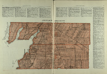
Lots 63 and 64: Kings County
Description: The map shows lots 63 and 64 in Kings county. Shown are Northumberland Strait, Gulf of St. Lawrence, Murray Harbour, Island and River, points, Herring Ponds, landowners, acreage, roads, and railroads.
Province: Prince Edward Island
Type: cadastral maps
Date Issued (Source): 1927