| Title Proper |
Atlas of Province of Prince Edward Island, Canada and the World
|
|---|---|
| Description |
Cummins devotes most of its opening pages to a detailing of the Island’s contribution to the First World War or “European War”. This event had forever changed many communities on the Island.
More positively, new industries such as silver fox farming are also highlighted as are the continuing growth of the potato and lobster industries which would both become increasingly important in the 20th century. |
| Access Condition |
This material is provided for research, education, and private use only.
|
| Type | |
| Physical Location |
Robertson Library, UPEI
|
| Contributors |
Cartographer: Cummins Map Co
|
| Date Issued |
1927
|
| Publisher |
Cummins Map Co.
|
| Extent |
140, lxxii p. : ill.
|
| Subject (Geographic) |
Atlas of Province of Prince Edward Island, Canada and the World
In this collection
Displaying 136 - 153 of 153
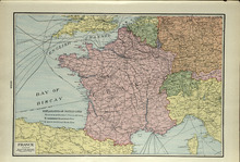
France
Description: The map shows France. Shown are a table of an Explaination of Battle Lines, English Channel, Bay of Biscay, cities, and towns.
Type: cadastral maps
Date Issued (Source): 1927
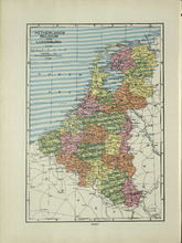
Netherlands, Belgium and Luxemburg
Description: The map shows the Netherlands, Belgium and Luxemburg. Shown are the North Sea, towns, and cities.
Type: cadastral maps
Date Issued (Source): 1927
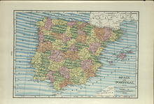
Spain and Portugal
Description: The map shows Spain and Portugal. Shown are The Atlantic Ocean, Mediterranean Sea, Balearic Islands, Bay of Biscay, Gulf of Lyons, Pyrenees Mountains, towns, and cities.
Type: cadastral maps
Date Issued (Source): 1927
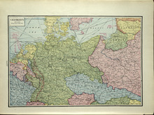
Germany
Description: The map shows Germany. Shown are the North and Baltic Sea, cables, Towns, and Cities.
Type: cadastral maps
Date Issued (Source): 1927
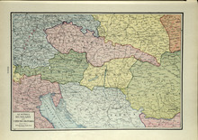
Austria, Hungary and Czecho-Slovakia
Description: The map shows Austria, and Hungary and Czecho-Slovakia. Shown are other countries, towns, and cities, and the Adriatic Sea.
Type: cadastral maps
Date Issued (Source): 1927
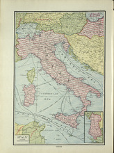
Italy
Description: The map shows Italy. Shown are the Adriatic, Tyrrhenian, Mediterranean, and Sicilian Sea, cables, countries, cities, and towns.
Type: cadastral maps
Date Issued (Source): 1927
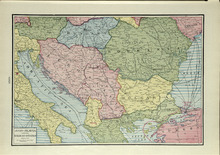
Jugo-Slavia and the Balkan-States
Description: The map shows Jugo-Slavia and the Balkan-States. Shown are the Black, Adriatica, and Aegean Sea, cables, towns, and cities.
Type: cadastral maps
Date Issued (Source): 1927
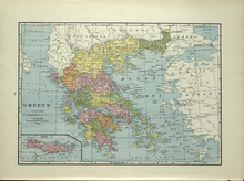
Greece
Description: The map shows Greece. Shown are the Egean, Adratic, Marmara, Black, Ionian, and Crete Sea, Ionian Islands, other bodies of water, cities and towns. Also an insert of Crete.
Type: cadastral maps
Date Issued (Source): 1927
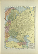
Russia: Ukrainia, Finland, Esthonia, Lativia, and Lithuania
Description: The map shows Russia, Ukrainia, Finland, Esthonia, Lativia, and Lithuania. Shown are the Arctic Ocean, Kara, Baltic, Black, Mediterranean, and Caspian Sea, countries, cities and towns.
Type: cadastral maps
Date Issued (Source): 1927
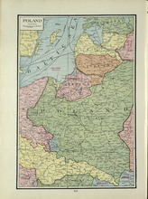
Poland
Description: The map shows Poland. Shown are the Baltic Sea, Gulf of Riga, Bay of Danzig, countries, towns, and cities.
Type: cadastral maps
Date Issued (Source): 1927
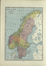
Norway and Sweden
Description: The map shows Norway and Sweden. Shown are tge Arctic, and North Atlantic Ocean, North and Baltic Sea, gulfs, lakes, islands, cities and towns.
Type: cadastral maps
Date Issued (Source): 1927
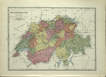
Switzerland
Description: The map shows Switzerland. Shown are lakes, rivers, Bernina and Bernese Alps, mountains, countries, cities, and towns.
Type: cadastral maps
Date Issued (Source): 1927
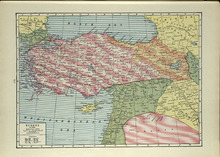
Turkey: In Asia
Description: The map shows Turkey, in Asia. Shown are the Black and Mediterranean Sea, a table of Explanation, countries, cities, and towns.
Type: cadastral maps
Date Issued (Source): 1927
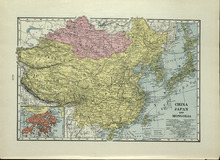
China, Japan, and Mongolia
Description: The map shows China, Japan, and Mongolia. Shown are the Pacific Ocean, Japan, China, Eastren, and Yellow Sea, capitals of countries, treatly ports, steamship lines, the Great Wall, railroads,… more
Type: cadastral maps
Date Issued (Source): 1927
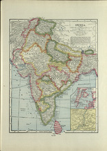
India
Description: The map shows India. Shown are Arabian Sea, Bay of Bengal, coasts, islands, China Empire, cities, railroads, canals, towns and two inserts of Bombay, Calcutta and Vicinity.
Type: cadastral maps
Date Issued (Source): 1927
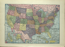
Map of the United States
Description: The map shows the United States. Shown are the Pacific and Atlantic Ocean, dominion of Canada, states, cities and towns.
Type: cadastral maps
Date Issued (Source): 1927