| Title Proper |
Atlas of Province of Prince Edward Island, Canada and the World
|
|---|---|
| Description |
Cummins devotes most of its opening pages to a detailing of the Island’s contribution to the First World War or “European War”. This event had forever changed many communities on the Island.
More positively, new industries such as silver fox farming are also highlighted as are the continuing growth of the potato and lobster industries which would both become increasingly important in the 20th century. |
| Access Condition |
This material is provided for research, education, and private use only.
|
| Type | |
| Physical Location |
Robertson Library, UPEI
|
| Contributors |
Cartographer: Cummins Map Co
|
| Date Issued |
1927
|
| Publisher |
Cummins Map Co.
|
| Extent |
140, lxxii p. : ill.
|
| Subject (Geographic) |
Atlas of Province of Prince Edward Island, Canada and the World
In this collection
Displaying 28 - 54 of 153
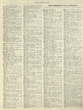
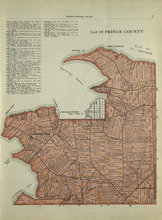
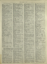
Rural Directory - Lot 12, Prince County
Description: A directory listing of residents of lot 12
Province: Prince Edward Island
Type: text
Date Issued (Source): 1927
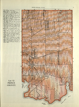
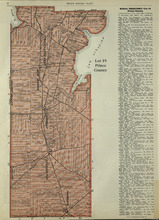
Lot 12: Prince County
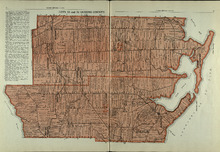
Description: The map shows Lot 12 in Prince county. Shown are roads, landowners, acreage, The Narrows, rivers, and a railroad.
Province: Prince Edward Island
Type: cadastral maps
Date Issued (Source): 1927
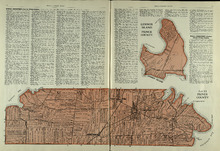
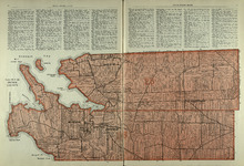
Lot 13, Lennox Island: Prince County
Description: The map shows Lot 13 in Prince county. Shown are bays, roads, creeks, and towns. Also shown in a smaller map at the top is Lennox Island. Shown there are landowners, peat bogs, and Gull, Salt Grass,… more
Province: Prince Edward Island
Date Issued (Source): 1927
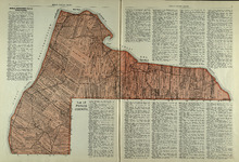
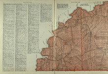
Lot 15: Prince County
Description: The map shows lot 15 in Prince county. Shown are Red Head, Cape Egmont, Egmont Bay, the Northumberland Strait, rivers, landowners, acreage, and roads.
Province: Prince Edward Island
Type: cadastral maps
Date Issued (Source): 1927
Lots 14 and 16 : Prince County
Description: The map shows lots 14 and 16, in Prince county. Shown are bays, ponds, coves, landowners, acreage, rivers, and roads.
Province: Prince Edward Island
Type: cadastral maps
Date Issued (Source): 1927
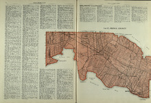
Lot 17: Prince County
Description: The map shows Lot 17 in Prince county. Shown are byas, coves, landowners, acreage, towns, cities, and roads.
Province: Prince Edward Island
Type: cadastral maps
Date Issued (Source): 1927
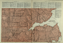
Lots 27 and 28: Prince County
Description: The map shows lots 27 and 28 in Prince county. Shown are the Northumberland Strait, points, coves, landowners, acreage, roads, and a railroad.
Province: Prince Edward Island
Type: cadastral maps
Date Issued (Source): 1927
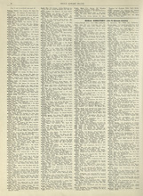
Rural Directory - Lots 27 and 28, Prince County and Lot 67, Queens county
Description: A directory listing of residents of lots 27 and 28 in Prince County and lot 67 in Queens County
Province: Prince Edward Island
Type: text
Date Issued (Source): 1927
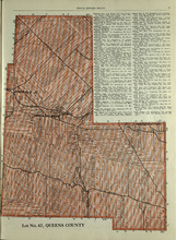
Lot No. 67: Queens County
Description: The map shows lot 67 in Queens county.Shown are roads, railroads, landowners, acreage, and Emerald Junction.
Province: Prince Edward Island
Type: cadastral maps
Date Issued (Source): 1927
Lot 20 and 21: Queens County
Description: The map shows lots 20 and 21 in Queens county. Shown are the Gulf of St. Lawrence, New London River and Bay, capes, ponds, rivers, landowners, acreage, and roads.
Province: Prince Edward Island
Type: cadastral maps
Date Issued (Source): 1927
Lots 22 and 23: Queens County
Description: The map shows lots 22 and 23 in Queens county. Shown are rivers, roads, railroads, landowners, acreage, New London bay and the Gulf of St. Lawrence.
Province: Prince Edward Island
Type: cadastral maps
Date Issued (Source): 1927
Lot 24: Queens County
Description: The map shows lot 24 in Queens county. Shown are the Gulf of St. Lawrence, Rustico Bay and Harbour, river, cape, roads, landowners, and acreage.
Province: Prince Edward Island
Type: cadastral maps
Date Issued (Source): 1927
Rural Directory - Lots 24, 29, and 30, Queens County
Description: A directory listing of residents of lots 24, 29, and 30
Province: Prince Edward Island
Type: text
Date Issued (Source): 1927
Rural Directory - Lots 29 and 30, Queens County
Description: A directory listing of residents of lots 29 and 30.
Province: Prince Edward Island
Type: text
Date Issued (Source): 1927
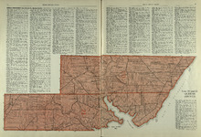
Lots 29 and 30: Queens County
Description: The map shows lots 29 and 30 in Queens county. Shown are roads, landowners, acreage, the Northumberland Strait, Westmoreland Harbour, and Sable River.
Province: Prince Edward Island
Type: cadastral maps
Date Issued (Source): 1927
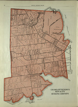
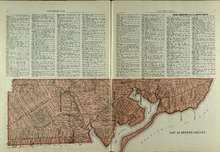
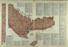
Charlottetown Royalty: Queens County
Description: The map shows the City of Charlottetown in Queens county. Shown are the Hillsborough and York Rivers. farms, landowners, acreage, roads, and railroads.
Province: Prince Edward Island
Type: cadastral maps
Date Issued (Source): 1927
Lots 31 and 32: Queens County
Description: The map shows lots 31 and 32 in Queens county. Shown are rivers, landowners, acreage, roads, and railroads
Province: Prince Edward Island
Type: cadastral maps
Date Issued (Source): 1927
Rural Directory - Lots 31 - 34, Queens County
Description: A directory listing of residents of lots 31, 32, 33, and 34.
Province: Prince Edward Island
Type: text
Date Issued (Source): 1927
Rural Directory - Lots 33 and 34, Queens County
Description: A directory listing of residents of lots 33 and 34.
Province: Prince Edward Island
Type: text
Date Issued (Source): 1927
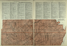
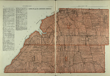
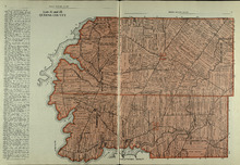
Lots 33 and 34 : Queens County
Description: The map shows lots 33 and 34 in Queens county. Shown are the Gulf of St. Lawrence, Cove Head and Rustico Bay, Hillsborough River, landowners, acreage, roads, railroads, Royalty Junction and Suffolk… more
Province: Prince Edward Island
Type: cadastral maps
Date Issued (Source): 1927
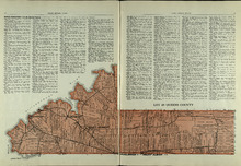
Lot 65: Queens County
Description: The map shows Lot 65 in Queens County. Shown are the Northumberland Strait, Hillsborough Bay, Elliott River, roads, landowners, acreage, and towns.
Province: Prince Edward Island
Type: cadastral maps
Date Issued (Source): 1927
Lot 48: Queens County
Description: The map shows lot 48 in Queens county. Shown are Hillsborough River, Fullerton Creek, railroads, roads, landowners, and acreage.
Province: Prince Edward Island
Type: cadastral maps
Date Issued (Source): 1927