Displaying 757 - 864 of 992
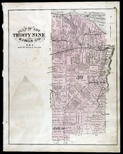
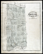
Plan of Lot Thirty Nine: Kings Co., P.E.I.
Description: The map shows lot 39 in Kings county. Shown are a gulf, lake, sand, light house, post offices, landowners and acreage, roads, railroads and stations, rivers, school houses, churches, and an Indian… more
Publisher: J. H. Meacham & company
Province: Prince Edward Island
Type: cadastral maps
Date Issued (Source): 1880
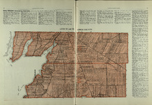
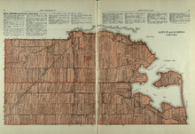
Lots 53 and 54: Kings County
Description: The map shows lots 53 and 54 in Kings county. Shown are bays, rivers, an Indian marsh, landowners, acreage, roads, and railroads.
Publisher: Cummins Map Co.
Province: Prince Edward Island
Date Issued (Source): 1927
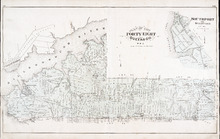
Plan of Lot Fourty Eight: Queens Co., P.E.I.
Description: The map showing lots 48 in Queens county. Shown are the commissioners line, rivers, coves, marsh, creeks, ponds, lakes, roads, landowners and acreage, asylum, hospital, and post offices. Graphic… more
Publisher: J. H. Meacham & company
Province: Prince Edward Island
Type: cadastral maps
Date Issued (Source): 1880
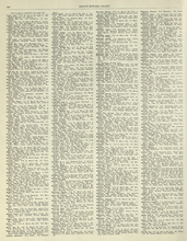
Rural Directory - Lots 53 and 54, Kings County
Description: A directory listing of residents of lots 53 and 54.
Publisher: Cummins Map Co.
Province: Prince Edward Island
Type: text
Date Issued (Source): 1927
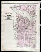
Plan of Lot Fourty: Kings Co., P.E.I.
Description: The map shows Lot 40 in Kings county. Shown are a bay, gulf, river, ponds, school house, churches, wharf, post office, roads, landowners and acreage, and mills. Compass.
Publisher: J. H. Meacham & company
Province: Prince Edward Island
Type: cadastral maps
Date Issued (Source): 1880
Rural Directory - Lots 55 and 56, Kings County
Description: A directory listing of residents of lots 55 and 56
Publisher: Cummins Map Co.
Province: Prince Edward Island
Type: text
Date Issued (Source): 1927
Lots 55 and 56: Kings County
Description: The map shows lots 55 and 56 in Kings county. Shown are bays, rivers, ponds, landowners, acreage, roads, coves, and Boughton Island.
Publisher: Cummins Map Co.
Province: Prince Edward Island
Type: cadastral maps
Date Issued (Source): 1927
Plan of Lots 49 & 50: Queens Co., P.E.I.
Description: The map shows lot 49 & 50 in Queens County. Shown are roads, landowners and acreage, lakes, bays, coves, wharfs, post offices, churches, and schools. Graphic compass
Publisher: J. H. Meacham & company
Province: Prince Edward Island
Type: cadastral maps
Date Issued (Source): 1880
Lots 59 and 61: Kings County
Description: The map shows lots 59 and 61 in Kings county. Shown are Montague river, bays, points, coves, landowners, acreage, roads, creeks, and Panamure Island.
Publisher: Cummins Map Co.
Province: Prince Edward Island
Type: cadastral maps
Date Issued (Source): 1927
Rural Directory - Lots 59 and 61, Kings County
Description: A directory listing of residents of lots 59 and 61.
Publisher: Cummins Map Co.
Province: Prince Edward Island
Type: text
Date Issued (Source): 1927
Plan of Lot Forty One: Kings Co., P.E.I.
Description: The map shows lot 41 in Kings county. Shown are St. Peters bay, river, gulf, roads, landowners and acreage, railroad and station, post offices, mills, schools, and churches. Compass.
Publisher: J. H. Meacham & company
Province: Prince Edward Island
Type: cadastral maps
Date Issued (Source): 1880
Rural Directory - Lots 59, 61, 63, and 64, Kings County
Description: A directory listing of residents of lots 59 , 61, 63, and 64
Publisher: Cummins Map Co.
Province: Prince Edward Island
Type: text
Date Issued (Source): 1927
Plan of Lots 51, 52, & 66: Kings Co., P.E.I.
Description: The map shows lots 51, 52, & 66 in Kings county. Shown are roads, railroads and stations, landowners and acreage, streams, rivers, post offices, mills, and churches. Graphic compass.
Publisher: J. H. Meacham & company
Province: Prince Edward Island
Type: cadastral maps
Date Issued (Source): 1880
Lots 63 and 64: Kings County
Description: The map shows lots 63 and 64 in Kings county. Shown are Northumberland Strait, Gulf of St. Lawrence, Murray Harbour, Island and River, points, Herring Ponds, landowners, acreage, roads, and railroads.
Publisher: Cummins Map Co.
Province: Prince Edward Island
Type: cadastral maps
Date Issued (Source): 1927
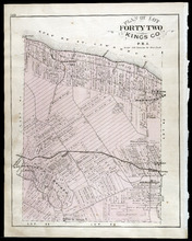
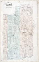
Plan of Lot Forty Two: Kings Co., P.E.I.
Description: The map shows lot 42 in Kings county. Shown are a gulf, marsh, roads, railroad and stations, post offices, school houses, rivers, and a brook. Compass.
Publisher: J. H. Meacham & company
Province: Prince Edward Island
Type: cadastral maps
Date Issued (Source): 1880
Rural Directory - Lots 63 and 64, Kings County
Description: A directory listing of residents of lots 63 and 64
Publisher: Cummins Map Co.
Province: Prince Edward Island
Type: text
Date Issued (Source): 1927
Rural Directory - Lots 63 and 64, Kings County
Description: A directory listing of residents of lots 63 and 64.
Publisher: Cummins Map Co.
Province: Prince Edward Island
Type: text
Date Issued (Source): 1927
Plan of Lots Fifty Three & Fifty Four: Kings Co., P.E.I.
Description: The map shows lots 53 & 54 in Kings county. Shown are roads, railroads and stations, landowners and acreage, rivers, creeks, wharfs, post offices, and mills. Graphic compass.
Publisher: J. H. Meacham & company
Province: Prince Edward Island
Type: cadastral maps
Date Issued (Source): 1880
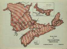
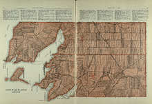
Road Map of the Maritime Provinces
Description: The map shows the Provinces of Prince Edward Island, New Brunswick, Nova Scotia, and Cape Breton Island. Also shown are cities and towns and a Reference table that shows different road conditions.
Publisher: Cummins Map Co.
Province: Prince Edward Island, New Brunswick, Nova Scotia, Cape Breton Island
Type: transportation maps
Date Issued (Source): 1927
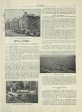
Nova Scotia - 1
Description: Text provides information of the history and industries in Nova Scotia
Publisher: Cummins Map Co.
Province: Nova Scotia
Type: text
Date Issued (Source): 1927
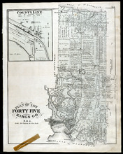
Plan of Lot Fourty Five: Kings Co., P.E.I.
Description: The map shows Lot 45 in Kings county. Shown are the gulf, bay, rivers, coves, post offices, cross, mills, roads, railroad, landowners and acreage, churches, hospital, harbour, and sand. Compass.
Publisher: J. H. Meacham & company
Province: Prince Edward Island
Type: cadastral maps
Date Issued (Source): 1880
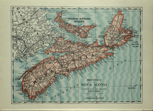
Province of Novia Scotia and Prince Edward Island Canada
Description: The map shows the Provinces of Novia Scotia and Prince Edward Island Canada. Shown are Cape Breton Island, New Brunswick, Atlantic Ocean, Sable Island, Northumberland Strait, Bay of Fundy, roads,… more
Publisher: Cummins Map Co.
Province: Nova Scotia, Prince Edward Island, Cape Breton Island, New Brunswick
Type: cadastral maps
Date Issued (Source): 1927
Plan of Lots 55 & 56: Kings Co., P.E.I.
Description: The map shows lots 55 & 56 in Kings county. Shown are roads, landowners and acreage, crosses, rivers, ponds, creeks, bays, coves, sand, wharfs, mills, post offices, churches, schools, and… more
Publisher: J. H. Meacham & company
Province: Prince Edward Island
Type: cadastral maps
Date Issued (Source): 1880
Nova Scotia - 2
Description: Text provides information of the different industries of Nova Scotia such as mining, coal, foresty and agriculture
Publisher: Cummins Map Co.
Province: Nova Scotia
Type: text
Date Issued (Source): 1927
Plan of Lot Fourty Six: Kings Co., P.E.I.
Description: The map shows lot 46 in Kings county. Shown are a gulf, straits, pond, roads, landowners and acreage, school houses, post offices, mills, and sand. Compass.
Publisher: J. H. Meacham & company
Province: Prince Edward Island
Type: cadastral maps
Date Issued (Source): 1880
New Brunswick - 1
Description: Text provides information of history, government, and agriculture of New Brunswick.
Publisher: Cummins Map Co.
Province: New Brunswick
Type: text
Date Issued (Source): 1927
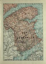
Province of New Brunswick and part of Quebec, Canada
Description: The map shows the Provinces of New Brunswick and part of Quebec, Canada. Shown are Prince Edward Island, United States, Nova Scotia, St. Lawrence River and Gulf, Northumberland Strait, Bay of Fundy,… more
Publisher: Cummins Map Co.
Province: Nova Scotia, Prince Edward Island, Quebec, New Brunswick
Type: cadastral maps
Date Issued (Source): 1927
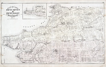
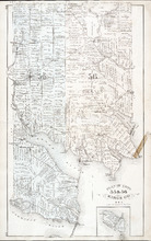
Plan of Lots Fifty Seven & Fifty Eight: Queens Co., P.E.I.
Description: The map shows lots 57 & 58 in Queens county. Includes an inset map of Prim Island / Point Prim. Shown are roads, landowners and acreage, crosses, rivers, ponds, creeks, bays, coves, sand, wharfs… more
Publisher: J. H. Meacham & company
Province: Prince Edward Island
Type: cadastral maps
Date Issued (Source): 1880
New Brunswick - 2
Description: Text provides information of Farming and Forestry in New Brunswick
Publisher: Cummins Map Co.
Province: New Brunswick
Type: text
Date Issued (Source): 1927
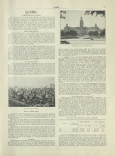
Quebec - 1
Description: Text provides information of history, population, and farming industry of Quebec
Publisher: Cummins Map Co.
Province: Quebec
Type: text
Date Issued (Source): 1927
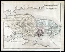
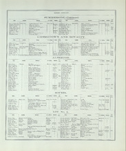
Georgetown Royalty and Reserve Land: Kings Co., P.E.I.
Description: The map shows Georgetown Royalty and Reserve Land in Kings county. Shown are rivers, roads, railroads and stations, landowners and acreage, beaches, Georgetown commons, square, market, court house,… more
Publisher: J. H. Meacham & company
Province: Prince Edward Island
Type: cadastral maps
Date Issued (Source): 1880
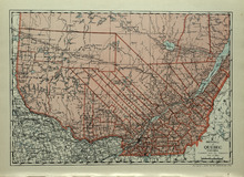
Province of Quebec, Canada
Description: The map shows the province of Quebec in Canada. Shown are Ontario, New York, Maine, towns, cities, raods, railroads, and St. Lawrence River.
Publisher: Cummins Map Co.
Province: Quebec
Type: cadastral maps
Date Issued (Source): 1927
Plan of Lots 59 & 61: Kings Co., P.E.I.
Description: The map shows lots 59 & 61 in Kings county. Shown are roads, landowners and acreage, crosses, rivers, ponds, creeks, bays, coves, sand, wharfs, mills, post offices, churches, schools, light… more
Publisher: J. H. Meacham & company
Province: Prince Edward Island
Type: cadastral maps
Date Issued (Source): 1880
Quebec - 2
Description: Text provides information of the farming industry of Quebec
Publisher: Cummins Map Co.
Province: Quebec
Type: text
Date Issued (Source): 1927
Plan of Lot Forty Seven: Kings Co., P.E.I.
Description: The map shows Lot 47 in Kings county. Shown are a gulf, straits, rivers, lakes, swamp, sand, fishing huts, mills, post offices, churches, creeks, light house, and pond. Compass.
Publisher: J. H. Meacham & company
Province: Prince Edward Island
Type: cadastral maps
Date Issued (Source): 1880
Ontario - 1
Description: Text provides information on the history and farming industries of Ontario
Publisher: Cummins Map Co.
Province: Ontario
Type: text
Date Issued (Source): 1927
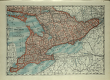
Province of Ontario, Canada
Description: The map shows the Province of Ontario, Canada. Shown are Georgian Bay, Lake Ontario, Erie, and Huron, Michigan, New York, roads, towns and cities.
Publisher: Cummins Map Co.
Province: Ontario
Type: cadastral maps
Date Issued (Source): 1927
Plan of Lot Sixty & Sixty Two: Queens Co., P.E.I.
Description: The map shows lots 60 & 62 in Queens county. Shown are roads, landowners and acreage, rivers, straits, ponds, bays, creeks, sand, post offices, mills, churches, and school houses. Graphic compass.
Publisher: J. H. Meacham & company
Province: Prince Edward Island
Type: cadastral maps
Date Issued (Source): 1880

Ontario - 2
Description: Text provides information of the farming and other industries of Ontario
Publisher: Cummins Map Co.
Province: Ontario
Type: text
Date Issued (Source): 1927
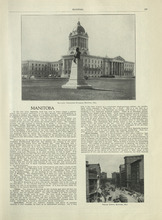
Manitoba - 1
Description: Text provides information of history, climate, and farming in Manitoba.
Publisher: Cummins Map Co.
Province: Manitoba
Type: text
Date Issued (Source): 1927
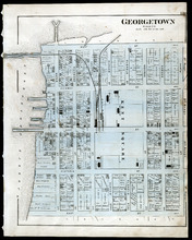
Georgetown: Kings Co., P.E.I.
Description: The map shows Georgetown in Kings county. Shown are wharfs, harbour, roads and streets, railroads and stations, landowners, houses, court house, scholl house, drill shed, Georgetown square, churches… more
Publisher: J. H. Meacham & company
Province: Prince Edward Island
Type: cadastral maps
Date Issued (Source): 1880
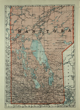
Province of Manitoba, Canada
Description: The map shows the province of Manitoba, Canada. Shown are the lakes, rivers and other bodies of water, and railroads.
Publisher: Cummins Map Co.
Province: Manitoba, Saskatchewan, Ontario
Type: cadastral maps
Date Issued (Source): 1927
Plan of Lots 63 & 64: Kings Co., P.E.I.
Description: The map shows Lots 63 & 64 in Kings county. Shown are roads, landowners and acreage, crosses, rivers, straits, ponds, gulfs, marshes, coves, wharfs, post offices, mills, churches, factories, and… more
Publisher: J. H. Meacham & company
Province: Prince Edward Island
Type: cadastral maps
Date Issued (Source): 1880
Manitoba - 2
Description: Text provides information of the landscape, industries, and government of Manitoba
Publisher: Cummins Map Co.
Province: Manitoba
Type: text
Date Issued (Source): 1927
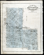
Plan of Lot Sixty Seven: Queens Co., P.E.I.
Description: The map shows Lot 67 in Queens county. Shown are roads, landowners and acreage, railroads and stations, post offices, church, and school houses. Compass.
Publisher: J. H. Meacham & company
Province: Prince Edward Island
Type: cadastral maps
Date Issued (Source): 1880
Saskatchewan - 1
Description: Text provides information of the history, government, and landscape of Saskatchewan
Publisher: Cummins Map Co.
Province: Saskatchewan
Type: text
Date Issued (Source): 1927
Province of Saskatchewan, Canada
Description: The map shows the province of Saskatchewan, Canada. Shown are rivers, lakes, and other bodies of water, roads, and railroads.
Publisher: Cummins Map Co.
Province: Saskatchewan, Alberta, Mantitoba
Type: cadastral maps
Date Issued (Source): 1927
Plan of Lot 65 : Queens Co., P.E.I.
Description: The map shows Lot 65 in Queens county. Shown are roads, landowners and acreage, creeks, rivers, straits, marshes, brooks, coves, sand, reef, fishing stage, wharfs, post offices, mills, churches,… more
Publisher: J. H. Meacham & company
Province: Prince Edward Island
Type: cadastral maps
Date Issued (Source): 1880
Saskatchewan - 2
Description: Text provides information of population, land, climate, and farming in Saskatchewan
Publisher: Cummins Map Co.
Province: Saskatchewan
Type: text
Date Issued (Source): 1927
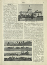
Alberta - 1
Description: Text provides information of different regions of Alberta, their history, and agriculture in Alberta
Publisher: Cummins Map Co.
Province: Alberta
Type: text
Date Issued (Source): 1927
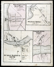
Port Selkirk Farm or Brush Wharf, Stanley Bridge: Murray Harbour South, and Vernon River Bridge
Description: The map shows Port Selkirk Farm or Brush Wharf lot 57 in Queens county. Shown are a river, wharf, road and street, landowners, and measurements. Compass.
Publisher: J. H. Meacham & company
Province: Prince Edward Island
Type: cadastral maps
Date Issued (Source): 1880
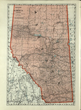
Province of Alberta, Canada
Description: The map shows the province of Alberta, Canada. Shown are bodies of water, rivers, lakes, etc., cities and towns, roads and railroads.
Publisher: Cummins Map Co.
Province: Alberta, British Columbia, Saskatchewan
Type: cadastral maps
Date Issued (Source): 1927
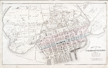
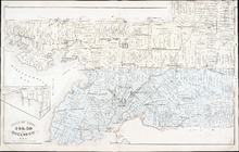
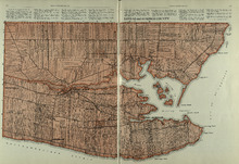
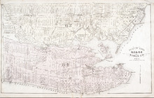
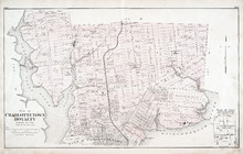
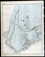
Map of the City of Charlottetown
Description: The map shows the city of Charlottetown. Shown are the wards, roads, landowners and acreage, asylums, ponds, rivers, houses, cemetery, estates, churches, lakes, parks, wharfs, and Charlottetown… more
Publisher: J. H. Meacham & company
Province: Prince Edward Island
Type: cadastral maps
Date Issued (Source): 1880
Alberta - 2
Description: Text provides information of different industries in Alberta, and the population in Alberta
Publisher: Cummins Map Co.
Province: Alberta
Type: text
Date Issued (Source): 1927
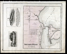
Souris West Lot 44: Kings Co., P.E.I.
Description: The map shows Lot 44 in Souris West, Kings county. Shown are a bay, harbour, river, railroad, landowners, roads, houses and buildings, school houses, businesses, and shipyards. Compass.
Publisher: J. H. Meacham & company
Province: Prince Edward Island
Type: cadastral maps
Date Issued: 1880
Date Issued (Source): 1880
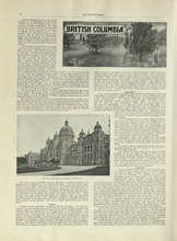
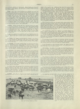
British Columbia - 1
Description: Text provides information of history, climate, lumbering, and agriculture in British Columbia
Publisher: Cummins Map Co.
Province: British Columbia
Type: text
Date Issued (Source): 1927
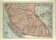
Province of British Columbia, Canada
Description: The map shows the province of British Columbia, Canada. Shown are the Pacific Ocean, Rocky Mountains, Vancouver Island, mountains, roads, and railroads.
Publisher: Cummins Map Co.
Province: British Columbia, Alberta
Type: cadastral maps
Date Issued (Source): 1927
Plan of Charlottetown Royalty: Queens Co., P.E.I.
Description: The map shows the city of Charlottetown and a plan for lots. Shown are rivers, creeks, roads, railroad and stations, landowners and acreage, mills, park, bridge, college, farms, asylums, and a… more
Publisher: J. H. Meacham & company
Province: Prince Edward Island
Type: cadastral maps
Date Issued (Source): 1880
British Columbia - 2
Description: Text provides information of the population and the various industries in British Columbia, such as mining, fishing, manufacturing, and transportation.
Publisher: Cummins Map Co.
Province: British Columbia
Type: text
Date Issued (Source): 1927
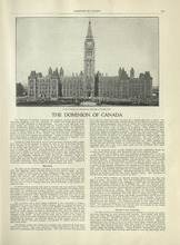
The Dominion of Canada - 1
Description: Text provides information of the history of Canada as a dominion and the establishment of the provinces and territories.
Publisher: Cummins Map Co.
Type: text
Date Issued (Source): 1927
The Dominion of Canada - 2
Description: Text provides information of the physical features of the land dividing each provinces and territories, and the industries that belong to each province and territory
Publisher: Cummins Map Co.
Province: Yukon, Northwest Territories
Type: text
Date Issued (Source): 1927
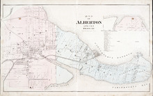
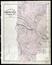
Map of Alberton Lots 4 & 5: Prince Co., P.E.I.
Description: The map shows lots 4 & 5 in the town of Alberton, Prince county. Shown are rivers, creeks, lakes, wharfs, shipyard, roads, railroad, landowners and acreage, mills, churches and cemetery. Compass… more
Publisher: J. H. Meacham & company
Province: Prince Edward Island
Type: cadastral maps
Date Issued (Source): 1880
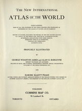
Title Page - International Atlas
Description: The title page for the New International Atlas of the World
Publisher: Cummins Map Co.
Type: text
Date Issued (Source): 1927
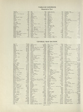
Table of Contents - International Atlas
Description: The table of contents page that shows the list of countries and maps of countries and the page they are mentioned
Publisher: Cummins Map Co.
Type: text
Date Issued (Source): 1927
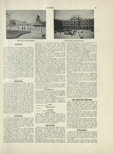
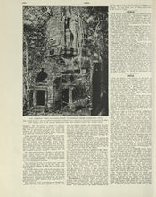
Europe - 1
Description: Text provides an introduction to Europe and gives the general history, population, climate, and notable industries of Austria, Belgium, the British Empire, and Bulgaria
Publisher: Cummins Map Co.
Type: text
Date Issued (Source): 1927
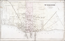
Summerside: Prince Co.
Description: The map shows the city of Summerside. Shown are the wards, roads, landowners and acreage, harbour, barracks, schools, squares, shipyards, railroad and station, and wharfs. Compass.
Publisher: J. H. Meacham & company
Province: Prince Edward Island
Type: cadastral maps
Date Issued (Source): 1880
Europe - 2
Description: Text provides information on the general history, population, climate, and notable industries of Czecho-Slovakia and Denmark
Publisher: Cummins Map Co.
Type: text
Date Issued (Source): 1927
Europe - 3
Description: Text provides information on the general history, population, climate, and notable industries of England, Wales, Esthonia, and Finland
Publisher: Cummins Map Co.
Type: text
Date Issued (Source): 1927
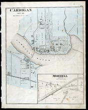
Cardigan Lot 53: Morrell Lot 40
Description: The map shows lot 53 in Cardigan. Shown are a river, roads, railroads, lots, landowners, school house, buildings, houses, wharfs and creeks. Compass.
Publisher: J. H. Meacham & company
Province: Prince Edward Island
Type: cadastral maps
Date Issued (Source): 1880
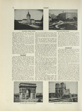
Europe - 4
Description: Text provides information on the general history, population, climate, and notable industries of France and Germany
Publisher: Cummins Map Co.
Type: text
Date Issued (Source): 1927

Montague Bridge Lots 59 & 52: Kings Co., P.E.I.
Description: The map shows lots 59 & 52 in Montague Bridge, Kings county. Shown are rivers, wharfs, shipyards, roads, landowners and acreage, halls, churches, buildings and businesses. Compass.
Publisher: J. H. Meacham & company
Province: Prince Edward Island
Type: cadastral maps
Date Issued (Source): 1880
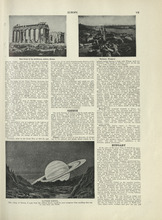
Europe - 5
Description: Text provides information on the general history, population, climate, and notable industries of Greece and Hungary
Publisher: Cummins Map Co.
Type: text
Date Issued (Source): 1927
Souris
Description: The map shows a part of Souris. Shown are the Souris river, sand beach, roads, railroads, churhces, landowners, houses, buildings and businesses. Compass
Publisher: J. H. Meacham & company
Province: Prince Edward Island
Type: cadastral maps
Date Issued (Source): 1880
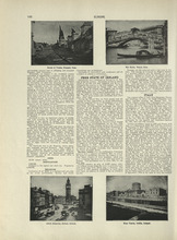
Europe - 6
Description: Text provides information on the general history, population, climate, and notable industries of Free State of Ireland, and Italy
Publisher: Cummins Map Co.
Type: text
Date Issued (Source): 1927
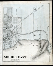
Souris East: Lot Forty Five
Description: The map shows Lot 45 in Souris East. Shown are the Souris Harbour and Bay, wharfs, roads and streets, railroads, lobster factory, landowners, houses, buildings and businesses. Compass
Publisher: J. H. Meacham & company
Province: Prince Edward Island
Type: cadastral maps
Date Issued (Source): 1880
Europe - 7
Description: Text provides information on the general history, population, climate, and notable industries of Jugo-Slavia, Lithuania, and the Netherlands
Publisher: Cummins Map Co.
Type: text
Date Issued (Source): 1927
Europe - 8
Description: Text provides information on the general history, population, climate, and notable industries of Norway and Poland
Publisher: Cummins Map Co.
Type: text
Date Issued (Source): 1927
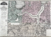
Map of the Province of Manitoba
Description: The map shows the province of Manitoba. Shown on the side are a Reference table and a Township diagram, lakes, roads, marshes, Indian Reserves, churches, rivers, and ponds. Compass.
Publisher: J. H. Meacham & company
Province: Manitoba
Type: cadastral maps
Date Issued (Source): 1880
Europe - 9
Description: Text provides information on the general history, population, climate, and notable industries of Portugal, Romania, Russia, Scotland, and Spain
Publisher: Cummins Map Co.
Type: text
Date Issued (Source): 1927
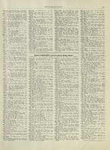
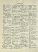
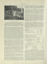
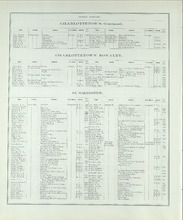
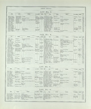
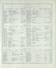
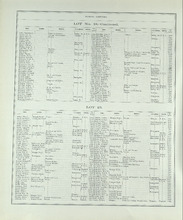
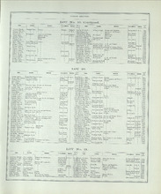
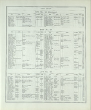
Patron's Directory - Page 165
Description: Patron's Directory of the Province of Prince Edward Island. Giving names of the principal professional and business men in the city, towns, and villages, a description of their business, and of… more
Type: text
Date of Part: 1880

Europe - 10
Description: Text provides information on the general history, population, climate, and notable industries of Sweden, Switzerland, Ukraine, and the Minor European States (Andorra, the Channel Islands, Crete,… more
Publisher: Cummins Map Co.
Type: text
Date Issued (Source): 1927
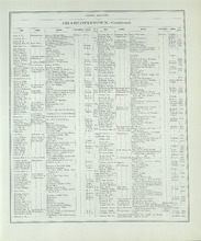
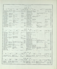
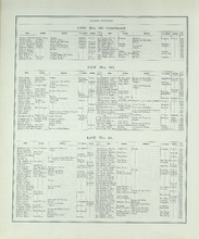
Patron's Directory - Page 166
Description: Patron's Directory of the Province of Prince Edward Island. Giving names of the principal professional and business men in the city, towns, and villages, a description of their business, and of… more
Type: text
Date of Part: 1880
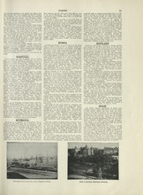
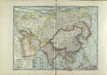
Asia - 1
Description: Text provides information on the general history, population, climate, and notable industries of Cyprus, Samos, Arabia, Armenia and Kurdestan, Hedjaz, Mesopotamia, and Turkey
Publisher: Cummins Map Co.
Type: text
Date Issued (Source): 1927
Patron's Directory - Page 167
Description: Patron's Directory of the Province of Prince Edward Island. Giving names of the principal professional and business men in the city, towns, and villages, a description of their business, and of… more
Type: text
Date of Part: 1880
Patron's Directory - Page 168
Description: Patron's Directory of the Province of Prince Edward Island. Giving names of the principal professional and business men in the city, towns, and villages, a description of their business, and of… more
Type: text
Date of Part: 1880
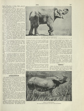
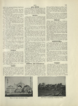
Asia - 3
Description: Text provides information on the general history, population, climate, and notable industries of Afghanistan and Persia.
Publisher: Cummins Map Co.
Type: text
Date Issued (Source): 1927
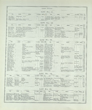
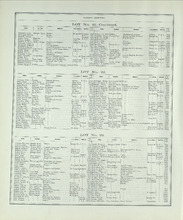
Patron's Directory - Page 169
Description: Patron's Directory of the Province of Prince Edward Island. Giving names of the principal professional and business men in the city, towns, and villages, a description of their business, and of… more
Type: text
Date of Part: 1880
Patron's Directory - Page 170
Description: Patron's Directory of the Province of Prince Edward Island. Giving names of the principal professional and business men in the city, towns, and villages, a description of their business, and of… more
Type: text
Date of Part: 1880
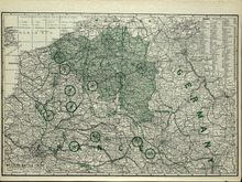
Western Battle Front
Description: The map shows the Western Battle Front in France, Belgium, and Germany. Shown are fortresses and fortified towns, forts, airship bases, wireless stations, railways, highways, and canals.
Publisher: Cummins Map Co.
Type: cadastral maps
Date Issued (Source): 1927
Patron's Directory - Page 171
Description: Patron's Directory of the Province of Prince Edward Island. Giving names of the principal professional and business men in the city, towns, and villages, a description of their business, and of… more
Type: text
Date of Part: 1880
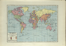
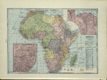
The World: Showing Principal Nations' Colonial Possessions
Description: The map shows the world and colonial possessions. Shown is a coloured table of the principal Nations' Colonial Possessions, countries, oceans and coordinates. more
Publisher: Cummins Map Co.
Type: cadastral maps
Date Issued (Source): 1927
Patron's Directory - Page 172
Description: Patron's Directory of the Province of Prince Edward Island. Giving names of the principal professional and business men in the city, towns, and villages, a description of their business, and of… more
Type: text
Date of Part: 1880
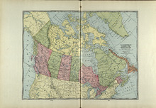
The Dominion of Canada and Newfoundland
Description: The map shows the dominion of Canada and Newfoundland. Shown are all provinces, territories, Greenland, and United States, oceans, bays, and mountains.
Publisher: Cummins Map Co.
Type: cadastral maps
Date Issued (Source): 1927
Patron's Directory - Page 173
Description: Patron's Directory of the Province of Prince Edward Island. Giving names of the principal professional and business men in the city, towns, and villages, a description of their business, and of… more
Type: text
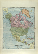
North America
Description: The map shows North America. Shown is the dominion of Canada, United States, Mexico, Central America, bodies of water, and coordinates.
Publisher: Cummins Map Co.
Type: cadastral maps
Date Issued (Source): 1927
Patron's Directory - Page 174
Description: Patron's Directory of the Province of Prince Edward Island. Giving names of the principal professional and business men in the city, towns, and villages, a description of their business, and of… more
Type: text
Date of Part: 1880
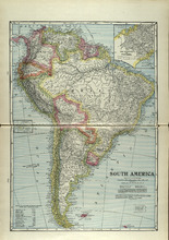
South America
Description: The map shows South America. Shown is a table of Political Divisions of South America with area and population, capitals of countries and states, railroads and telegraph lines, bodies of water,… more
Publisher: Cummins Map Co.
Type: cadastral maps
Date Issued (Source): 1927
Patron's Directory - Page 175
Description: Patron's Directory of the Province of Prince Edward Island. Giving names of the principal professional and business men in the city, towns, and villages, a description of their business, and of… more
Type: text
Date of Part: 1880
Patron's Directory - Page 176
Description: Patron's Directory of the Province of Prince Edward Island. Giving names of the principal professional and business men in the city, towns, and villages, a description of their business, and of… more
Type: text
Date of Part: 1880
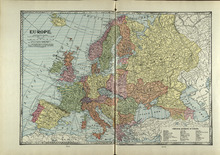
Europe
Description: The map shows the country of Eroupe. Shown are capitals of countries, railroads, submarine telegraph lines, a table of Principal Divisions of Europe, bodies of water, and coordinates.
Publisher: Cummins Map Co.
Type: cadastral maps
Date Issued (Source): 1927
Patron's Directory - Page 177
Description: Patron's Directory of the Province of Prince Edward Island. Giving names of the principal professional and business men in the city, towns, and villages, a description of their business, and of… more
Type: text
Date of Part: 1880
Patron's Directory - Page 178
Description: Patron's Directory of the Province of Prince Edward Island. Giving names of the principal professional and business men in the city, towns, and villages, a description of their business, and of… more
Type: text
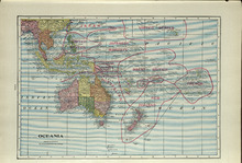
Oceania
Description: The map shows the Oceania. Shown are the Topic of Capricorn and the Equator lines, countries, great sand deserts, bodies of water, cities, and towns.
Publisher: Cummins Map Co.
Type: cadastral maps
Date Issued (Source): 1927
Patron's Directory - Page 179
Description: Patron's Directory of the Province of Prince Edward Island. Giving names of the principal professional and business men in the city, towns, and villages, a description of their business, and of… more
Type: text
Date of Part: 1880
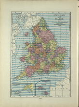
England and Wales
Description: The map shows England and Wales/ Shown are the North and Irish Sea, St. Patrick's, St. George's, Britol, and English Channel, cities and towns. more
Publisher: Cummins Map Co.
Type: cadastral maps
Date Issued (Source): 1927