Displaying 649 - 756 of 992
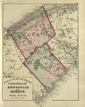
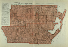
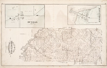
Coutnies of Annapolis and Queens : Nova Scotia
Description: The map shows the counties of Annapolis and Queens in Nova Scotia. Shown are rivers, roads, railroads, stations, lakes, harbours, cities, and towns.
Publisher: Roe Brothers
Province: Nova Scotia
Type: geological maps
Date Issued (Source): 1878

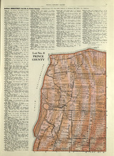
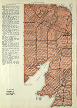
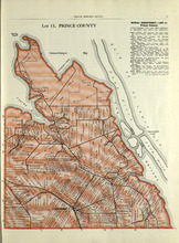
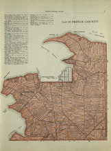
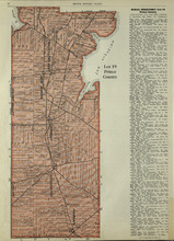
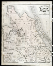
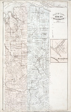
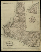
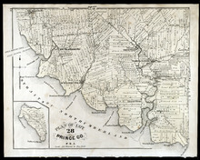
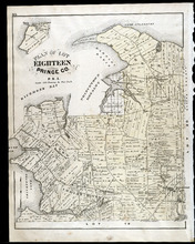
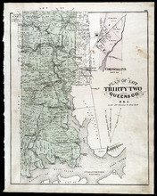
Plan of Lot One: Prince Co., P.E.I.
Description: Map showing the northWestern tip of the island. It names the gulfs, rivers, ponds, landowners and acreage, roads, and railroads. A graphic compass.
Publisher: J. H. Meacham & company
Province: Prince Edward Island
Type: cadastral maps
Date Issued (Source): 1880
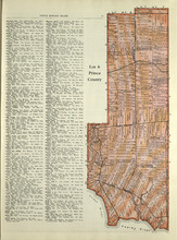
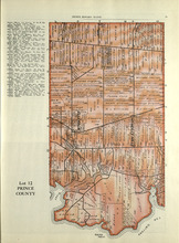
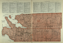
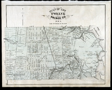
Lot 6: Prince County
Description: The map shows Lot 6 in Prince county. Shown are roads, landowners, acreage, railroad, rivers, and Oyster creek
Publisher: Cummins Map Co.
Province: Prince Edward Island
Date Issued (Source): 1927
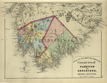
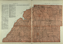
Counties of Yarmouth and Shelburne: Nova Scotia
Description: The map shows the counties of Yarmouth and Shelburne in Nova Scotia. Shown are railroads, stations, capes, coves, rivers, lakes, and harbours.
Publisher: Roe Brothers
Province: Nova Scotia
Type: geological maps
Date Issued (Source): 1878
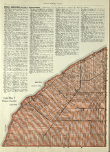
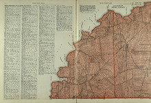
Lot No. 7: Prince County
Description: The map shows Lot 7 in Prince county. Shown are capes, coves, roads, landowners, and acreage.
Publisher: Cummins Map Co.
Province: Prince Edward Island
Type: cadastral maps
Date Issued (Source): 1927
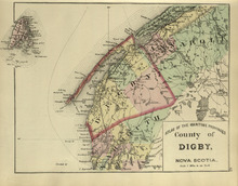
County of Digby: Nova Scotia
Description: The map shows the county of Digby in Nova Scotia. Shown are coves, rivers, capes, lakes, roads, railroads, bridges, cities and towns.
Publisher: Roe Brothers
Province: Nova Scotia
Type: geological maps
Date Issued (Source): 1878

Plan of Lot Six: Prince Co., P.E.I.
Description: Map showing lot six, bordering lots 5, 9, 10, 11 in Prince county. Shows rivers, creeks, railroads, roads, landowners, acreage, post offices, and buildings. Geographical compass
Publisher: J. H. Meacham & company
Province: Prince Edward Island
Type: cadastral maps
Date Issued (Source): 1880
Lot No. 8: Prince County
Description: The map shows Lot 8 in Prince County. Shown are the Nothumberland Strait, Wolf Inlet, Landowners, acreage, and roads.
Publisher: Cummins Map Co.
Province: Prince Edward Island
Type: cadastral maps
Date Issued (Source): 1927
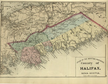
County of Halifax: Nova Scotia
Description: The map shows the county of Halifax in Nova Scotia. Shown are harbours, rivers, lakes, bays, gold mines, towns, and cities.
Publisher: Roe Brothers
Province: Nova Scotia
Type: geological maps
Date Issued (Source): 1878

Plan of Lots Two : Prince Co., P.E.I.
Description: Map showing lots 2
Publisher: J. H. Meacham & company
Province: Prince Edward Island
Type: cadastral maps
Date Issued (Source): 1880

Lot No. 9: Prince County
Description: The map shows Lot 9 in Prince county. Shown are roads, Egmont Bay, Dog Cove, roads, and railroads.
Publisher: Cummins Map Co.
Province: Prince Edward Island
Type: cadastral maps
Date Issued (Source): 1927
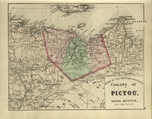
County of Pictou: Nova Scotia
Description: The map shows the county of Pictou in Nova Scotia. Shown are channel, rivers, lakes, harbours, railroads, lakes, mills, towns, and cities.
Publisher: Roe Brothers
Province: Nova Scotia
Type: geological maps
Date Issued (Source): 1878

Plan of Lot Seven: Prince Co., P.E.I.
Description: Map showing lot seven, bordering lots 4, 5, 6, and 8 in Prince county. Shows gulfs, railroads, roads, landowners, acreage, post offices, and buildings. Geographical compass
Publisher: J. H. Meacham & company
Province: Prince Edward Island
Type: cadastral maps
Date Issued (Source): 1880
Rural Directory - Lots 9 and 10, Prince County
Description: A directory listing of residents of lots 9 and 10.
Publisher: Cummins Map Co.
Province: Prince Edward Island
Type: text
Date Issued (Source): 1927
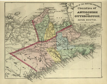
Couties of Antigonish and Guysborough: Nova Scotia
Description: The map shows the counties of Antigonish and Guysborough in Nova Scotia. Shown are rivers, bays, capes, lakes, points, roads, railroads, coves, harbours, cities, and towns.
Publisher: Roe Brothers
Province: Nova Scotia
Type: geological maps
Date Issued (Source): 1878

Tignish, Prince Co.: Campbellton
Description: The map shows Lot 1 in Tignish, Prince county. Shown are roads, landowners and acreage, a church, chapel, and convent, a cemetery, railroad and station, grammar school, business, and houses. Compass.
Publisher: J. H. Meacham & company
Province: Prince Edward Island
Type: cadastral maps
Date Issued (Source): 1880
Lot 10: Prince County
Description: The map shows Lot 10 in Prince county. Shown are rivers, roads, landowners, and acreage.
Publisher: Cummins Map Co.
Province: Prince Edward Island
Type: cadastral maps
Date Issued (Source): 1927
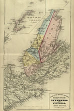
Counties of Inverness and Victoria: Nova Scotia
Description: The map shows the counties of Inverness and Victoria in Nova Scotia. Shown are bays, lakes, rivers, coves, gold mines, islands, harbours, cities, and towns.
Publisher: Roe Brothers
Province: Nova Scotia
Type: geological maps
Date Issued (Source): 1878
Lot 11: Prince County
Description: The map shows lot 11 in Prince county. Shown are roads, landowners, acreage, the Gulf of St. Lawrenece, Sand Hills, The Narrows, Cascumpeque Baym Foxley River, and Cavendish Inlet.
Publisher: Cummins Map Co.
Province: Prince Edward Island
Type: cadastral maps
Date Issued (Source): 1927
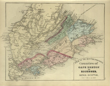
Counties of Cape Breton and Richmond: Nova Scotia>
Description: The map shows the counties of Cape Breton and Richmond in Nova Scotia. Shown are bays, lakes, points, channels, harbours, roads, railroads, towns, and cities.
Publisher: Roe Brothers
Province: Nova Scotia
Type: geological maps
Date Issued (Source): 1878
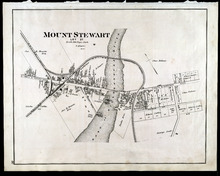
Mount Stewart: Lot 37
Description: The map shows lot 37 in Mount Stewart. Shown are roads, railroads and depot, landowners, houses, churches, Hillsborough river, wharfs, halls, and shipyard. Compass.
Publisher: J. H. Meacham & company
Province: Prince Edward Island
Type: cadastral maps
Date Issued (Source): 1880
Rural Directory - Lot 12, Prince County
Description: A directory listing of residents of lot 12
Publisher: Cummins Map Co.
Province: Prince Edward Island
Type: text
Date Issued (Source): 1927
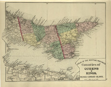
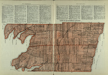
Counties of Queens and Kings: Prince Edward Island
Description: The map shows the counties of Queens and Kings in Prince Edward Island. Shown are bays, points, rivers, capes, coves, harbours, roads, railroads, cities, and towns.
Publisher: Roe Brothers
Province: Prince Edward Island
Type: geological maps
Date Issued (Source): 1878
Lot 12: Prince County
Description: The map shows Lot 12 in Prince county. Shown are roads, landowners, acreage, The Narrows, rivers, and a railroad.
Publisher: Cummins Map Co.
Province: Prince Edward Island
Type: cadastral maps
Date Issued (Source): 1927
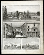
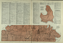
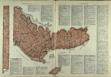
Property Sketches - Page 38
Description: Property sketches of the Residence of Hon. W. W. Sullivan, Charlottetown, P.E.I.; E.W. Taylor' Jewelry Store - interior and exterior, South Side Queen Square, Charlottetown, P.E.I.; The farms of… more
Publisher: J. H. Meacham & company
Province: Prince Edward Island
Type: image
Date Issued (Source): 1880
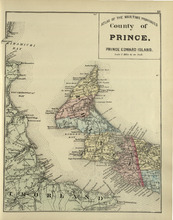
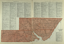
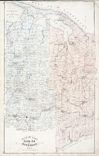
County of Prince: Prince Edward Island
Description: The map shows the county of Prince in Prince Edward Island. Shown are capes, bays, coves, roads, railroads, cities and towns.
Publisher: Roe Brothers
Province: Prince Edward Island
Type: geological maps
Date Issued (Source): 1878

Plan of Lot Four : Prince Co., P.E.I.
Description: Map showing lots four
Publisher: J. H. Meacham & company
Province: Prince Edward Island
Type: cadastral maps
Date Issued (Source): 1880
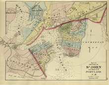
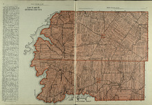
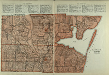
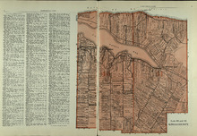
Map of the City of St. John and Town of Portland: N.B.
Description: The map shows the City of St. John and Town of Portland in New Brunswick. Shown are bays, rivers, harbour, lots, acreage, roads, railroads, towns, buildings, and names.
Publisher: Roe Brothers
Province: New Brunswick
Type: geological maps
Date Issued (Source): 1878
Lot 13, Lennox Island: Prince County
Description: The map shows Lot 13 in Prince county. Shown are bays, roads, creeks, and towns. Also shown in a smaller map at the top is Lennox Island. Shown there are landowners, peat bogs, and Gull, Salt Grass,… more
Publisher: Cummins Map Co.
Province: Prince Edward Island
Date Issued (Source): 1927
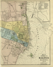
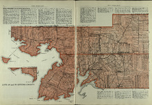
Map of the City of Halifax: Halifax Co. N.S.
Description: The map shows the city of Halifax, Halifax County in Nova Scotia. Shown are a Reference table, Halifax Harbour, pond, roads, wards, lots, buildings, and landowners.
Publisher: Roe Brothers
Province: Nova Scotia
Type: geographical maps
Date Issued (Source): 1878
Lot 15: Prince County
Description: The map shows lot 15 in Prince county. Shown are Red Head, Cape Egmont, Egmont Bay, the Northumberland Strait, rivers, landowners, acreage, and roads.
Publisher: Cummins Map Co.
Province: Prince Edward Island
Type: cadastral maps
Date Issued (Source): 1927

Plan of Lot Eight: Prince Co., P.E.I.
Description: The map shows lot 8 in Prince county. Shown are roads, landowners and acreage, rivers, Northumberland strait, ponds, lighthouses, post offices, churches, mills, and businesses. Compass.
Publisher: J. H. Meacham & company
Province: Prince Edward Island
Type: cadastral maps
Date Issued (Source): 1880
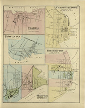
Chatham : Charlottetown : New Castle : City of Fredricton : Moncton: Northumberland Co. N.B..…
Description: The map shows Catham in the Northumberland county. New Brunswick. Shown are a river, wharf, streets, buildings, lots and a ferry crossing. The map shows Charlottetown in Queens county, Prince Edward… more
Publisher: Roe Brothers
Province: New Brunswick, Prince Edward Island
Type: geographical maps
Date Issued (Source): 1878
Lots 14 and 16 : Prince County
Description: The map shows lots 14 and 16, in Prince county. Shown are bays, ponds, coves, landowners, acreage, rivers, and roads.
Publisher: Cummins Map Co.
Province: Prince Edward Island
Type: cadastral maps
Date Issued (Source): 1927

Plan of Lot Thirteen: Prince Co., P.E.I.
Description: Map showing lot thirteen, bordering lots 12, 14 and 15, in Prince county. Shows gulfs, straits, bays, rivers, ponds, creeks, railroads, roads, landowners, acreage, post offices, and buildings.… more
Publisher: J. H. Meacham & company
Province: Prince Edward Island
Type: cadastral maps
Date Issued (Source): 1880
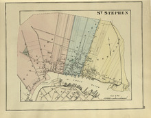
St. Stephen
Description: The map shows St. Stephen. Shown are a railroad and station, lots, wards, roads, buildings, and St. Croix River.
Publisher: Roe Brothers
Province: New Brunswick
Type: geographical maps
Date Issued (Source): 1878
Lot 17: Prince County
Description: The map shows Lot 17 in Prince county. Shown are byas, coves, landowners, acreage, towns, cities, and roads.
Publisher: Cummins Map Co.
Province: Prince Edward Island
Type: cadastral maps
Date Issued (Source): 1927

Plan of Lot Nine: Prince Co., P.E.I.
Description: The map shows lot 9 in Prince county. Shown are roads, landowners and acreage, Egmont bay, sand, Brae river, post offices, railroad and station, schools and churches. Compass.
Publisher: J. H. Meacham & company
Province: Prince Edward Island
Type: cadastral maps
Date Issued (Source): 1880
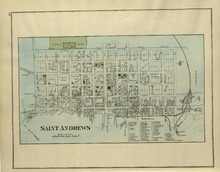
St. Andrews
Description: The map of St. Andrews. Shown are a Reference table, railroads and station, military lands, roads, lots, owners, and wharfs.
Publisher: Roe Brothers
Province: New Brunswick
Type: geographical maps
Date Issued (Source): 1878
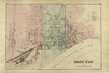
Moncton
Description: The map shows Moncton. Shown are a References table, wards, roads, railways and station, lots, buildings, landowners, and Petitcodiac River.
Publisher: Roe Brothers
Province: New Brunswick
Type: geographical maps
Date Issued (Source): 1878

Plan of Lot Fourteen & Sixteen : Prince Co., P.E.I.
Description: Map shows lots fourteen & sixteen in Prince county. Shown are roads, creeks, coves, rivers, post offices, railroads and stations, ferries, points, bays, landowners, acreage, churches, and… more
Publisher: J. H. Meacham & company
Province: Prince Edward Island
Type: cadastral maps
Date Issued (Source): 1880
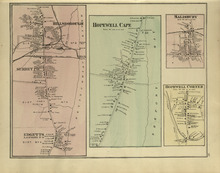
Hillsborough : Hopewell Cape : Salisbury : Hopewell Corner
Description: The map shows Hillsborough. Shown are buildings, lots, landowners, districts, Mill creek, wharfs, railways, post offices and shops. The map shows Hopewell Cape. Shown are buildings, landowners, roads… more
Publisher: Roe Brothers
Province: New Brunswick
Type: geographical maps
Date Issued (Source): 1878
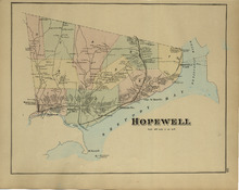
Hopewell
Description: The map shows Hopewell. Shown are a bay, island, rivers, wharf, railway and station, roads, landowners, and mountains.
Publisher: Roe Brothers
Province: New Brunswick
Type: geographical maps
Date Issued (Source): 1878

Plan of Lot Ten: Prince Co., P.E.I.
Description: The map shows lot 10 in Prince county. Shown are roads, rivers and creeks, railroad and station, post offices, a school, and landowners and acreage. Compass.
Publisher: J. H. Meacham & company
Province: Prince Edward Island
Type: cadastral maps
Date Issued (Source): 1880
Lots 25 & 26 : Prince County
Publisher: Cummins Map Co.
Type: cadastral maps
Date Issued (Source): 1927

Plan of Lot Seventeen: Prince Co., P.E.I.
Description: The map shows lot 17 along with two smaller maps of lot 17 and 23. The map includes landowners and acreage, railroads and stations, roads, districts, creeks, rivers, bays, marshes, brooks, coves,… more
Publisher: J. H. Meacham & company
Province: Prince Edward Island
Type: cadastral maps
Date Issued (Source): 1880
Lots 27 and 28: Prince County
Description: The map shows lots 27 and 28 in Prince county. Shown are the Northumberland Strait, points, coves, landowners, acreage, roads, and a railroad.
Publisher: Cummins Map Co.
Province: Prince Edward Island
Type: cadastral maps
Date Issued (Source): 1927
Plan of Lot Eleven: Prince Co., P.E.I.
Description: The map shows lot 11 in Prince county. Shown are roads, landowners and acreage, rivers, bays, coves, creeks, ponds, sand, railroad and station, post offices, and school houses. Compass.
Publisher: J. H. Meacham & company
Province: Prince Edward Island
Type: cadastral maps
Date Issued (Source): 1880
Rural Directory - Lots 27 and 28, Prince County and Lot 67, Queens county
Description: A directory listing of residents of lots 27 and 28 in Prince County and lot 67 in Queens County
Publisher: Cummins Map Co.
Province: Prince Edward Island
Type: text
Date Issued (Source): 1927
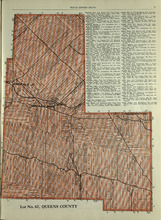
Lot No. 67: Queens County
Description: The map shows lot 67 in Queens county.Shown are roads, railroads, landowners, acreage, and Emerald Junction.
Publisher: Cummins Map Co.
Province: Prince Edward Island
Type: cadastral maps
Date Issued (Source): 1927

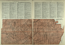
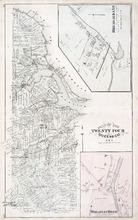
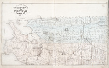
Plan of Lot Twenty One & Twenty: Queens Co., P.E.I.
Description: The map shows lots 21 and 20 (coloured in pink) in Queens county that border Prince county. The map names roads, landowners and acreage, creeks, gulfs, rivers, coves, fishing stations, post offices,… more
Publisher: J. H. Meacham & company
Province: Prince Edward Island
Type: cadastral maps
Date Issued (Source): 1880
Lot 20 and 21: Queens County
Description: The map shows lots 20 and 21 in Queens county. Shown are the Gulf of St. Lawrence, New London River and Bay, capes, ponds, rivers, landowners, acreage, and roads.
Publisher: Cummins Map Co.
Province: Prince Edward Island
Type: cadastral maps
Date Issued (Source): 1927
Lots 22 and 23: Queens County
Description: The map shows lots 22 and 23 in Queens county. Shown are rivers, roads, railroads, landowners, acreage, New London bay and the Gulf of St. Lawrence.
Publisher: Cummins Map Co.
Province: Prince Edward Island
Type: cadastral maps
Date Issued (Source): 1927

Victoria, Lot 29; Map of Lennox Island
Description: The page displays map of Victoria in Lot 29. Shown are roads and streets, a harbour, wharfs, landowners, post offices, buildings and school houses. Compass. The page also displays a map of Lennox… more
Publisher: J. H. Meacham & company
Province: Prince Edward Island
Type: cadastral maps
Date Issued (Source): 1880
Lot 24: Queens County
Description: The map shows lot 24 in Queens county. Shown are the Gulf of St. Lawrence, Rustico Bay and Harbour, river, cape, roads, landowners, and acreage.
Publisher: Cummins Map Co.
Province: Prince Edward Island
Type: cadastral maps
Date Issued (Source): 1927
Plan of Lots 22 & 23 : Queens Co., P.E.I.
Description: The map shows lots 22 and 23 in Queens county. The map names roads, landowners and acreage, churches, halls, post offices, railroads, rivers, bays, and guls. Graphic compass.
Publisher: J. H. Meacham & company
Province: Prince Edward Island
Type: cadastral maps
Date Issued (Source): 1880
Rural Directory - Lots 24, 29, and 30, Queens County
Description: A directory listing of residents of lots 24, 29, and 30
Publisher: Cummins Map Co.
Province: Prince Edward Island
Type: text
Date Issued (Source): 1927
Plan of Lot Twelve: Prince Co., P.E.I.
Description: The map shows lot 12 in Prince county. Shown are the Narrows, roads, railroad and station, ponds, landowners and acreage, school houses, creeks, rivers, and coves.
Publisher: J. H. Meacham & company
Province: Prince Edward Island
Type: cadastral maps
Date Issued (Source): 1880
Rural Directory - Lots 29 and 30, Queens County
Description: A directory listing of residents of lots 29 and 30.
Publisher: Cummins Map Co.
Province: Prince Edward Island
Type: text
Date Issued (Source): 1927
Lots 29 and 30: Queens County
Description: The map shows lots 29 and 30 in Queens county. Shown are roads, landowners, acreage, the Northumberland Strait, Westmoreland Harbour, and Sable River.
Publisher: Cummins Map Co.
Province: Prince Edward Island
Type: cadastral maps
Date Issued (Source): 1927
Plan of Lot Twenty Four: Queens Co., P.E.I.
Description: The map shows lot 24 in Queens county. Shown are rivers, gulfs, capes harbours, wharfs, lighthouses, fishing stages and holes, seaside hotels and bath houses, churches, crosses, post offices, roads,… more
Publisher: J. H. Meacham & company
Province: Prince Edward Island
Type: cadastral maps
Date Issued (Source): 1880
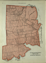
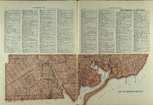
Charlottetown Royalty: Queens County
Description: The map shows the City of Charlottetown in Queens county. Shown are the Hillsborough and York Rivers. farms, landowners, acreage, roads, and railroads.
Publisher: Cummins Map Co.
Province: Prince Edward Island
Type: cadastral maps
Date Issued (Source): 1927
Lots 31 and 32: Queens County
Description: The map shows lots 31 and 32 in Queens county. Shown are rivers, landowners, acreage, roads, and railroads
Publisher: Cummins Map Co.
Province: Prince Edward Island
Type: cadastral maps
Date Issued (Source): 1927
Plan of Lot Fifteen: Prince Co., P.E.I.
Description: The map shown is lot 15 in Prince county. Shown are byas, wharfs, landonwers and acreage, roads, post offices, villages, rivers, coves, a commissioners line, fishing coves, a court house, and stores… more
Publisher: J. H. Meacham & company
Province: Prince Edward Island
Type: cadastral maps
Date Issued (Source): 1880
Rural Directory - Lots 31 - 34, Queens County
Description: A directory listing of residents of lots 31, 32, 33, and 34.
Publisher: Cummins Map Co.
Province: Prince Edward Island
Type: text
Date Issued (Source): 1927
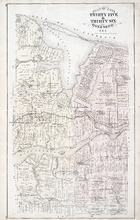
Plan of Lots Twenty Five & Twenty Six: Prince Co., P.E.I.
Description: The map shows lots 25 and 26 in Prince county. The map names roads, landowners and acreage, railroads, post offices, churches, harbours, lighthouses, hotels, coves. and rivers. Graphic compass.
Publisher: J. H. Meacham & company
Province: Prince Edward Island
Type: cadastral maps
Date Issued (Source): 1880
Rural Directory - Lots 33 and 34, Queens County
Description: A directory listing of residents of lots 33 and 34.
Publisher: Cummins Map Co.
Province: Prince Edward Island
Type: text
Date Issued (Source): 1927
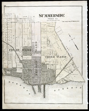
Summerside: Prince Co., P.E.I.
Description: The map shows the city of Summerside. Shown are the wards, a corportion line, landowners and acreage, roads, cemetery, buildings, railroad wharfs, and a harbour.
Publisher: J. H. Meacham & company
Province: Prince Edward Island
Type: cadastral maps
Date Issued (Source): 1880
Lots 33 and 34 : Queens County
Description: The map shows lots 33 and 34 in Queens county. Shown are the Gulf of St. Lawrence, Cove Head and Rustico Bay, Hillsborough River, landowners, acreage, roads, railroads, Royalty Junction and Suffolk… more
Publisher: Cummins Map Co.
Province: Prince Edward Island
Type: cadastral maps
Date Issued (Source): 1927
Lot 65: Queens County
Description: The map shows Lot 65 in Queens County. Shown are the Northumberland Strait, Hillsborough Bay, Elliott River, roads, landowners, acreage, and towns.
Publisher: Cummins Map Co.
Province: Prince Edward Island
Type: cadastral maps
Date Issued (Source): 1927

Plan of Lot Twenty Seven: Prince Co., P.E.I.
Description: The map shows lot 27 in Prince county. The map shows roads, railroads, crosses, ponds, rivers, bays, straits, coves, mills, post offices, and churhces. Graphic compass.
Publisher: J. H. Meacham & company
Province: Prince Edward Island
Type: cadastral maps
Date Issued (Source): 1880
Lot 48: Queens County
Description: The map shows lot 48 in Queens county. Shown are Hillsborough River, Fullerton Creek, railroads, roads, landowners, and acreage.
Publisher: Cummins Map Co.
Province: Prince Edward Island
Type: cadastral maps
Date Issued (Source): 1927
Lots 49 and 50: Queens County
Description: The map shows lots 49 and 50 in Queens county. Shown are bays, Governor Island, points, rivers, roads, railroads, landowners, and acreage.
Publisher: Cummins Map Co.
Province: Prince Edward Island
Type: cadastral maps
Date Issued (Source): 1927
Plan of Lot 28: Prince Co., P.E.I.
Description: The map shows lot 28 in Prince county. Shown are straits, coves, rivers, Anglo-American cable, Winter Crossing Ice Boats, post offices, churches, landowners and acreage, and factories. Compass.
Publisher: J. H. Meacham & company
Province: Prince Edward Island
Type: cadastral maps
Date Issued (Source): 1880
Rural Directory - Lots 49 and 50, Queens County
Description: A directory listing of residents of lots 49 and 50.
Publisher: Cummins Map Co.
Province: Prince Edward Island
Type: text
Date Issued (Source): 1927
Rural Directory - Lots 57 and 58, Queens County
Description: A directory listing of residents of lots 57 and 58.
Publisher: Cummins Map Co.
Province: Prince Edward Island
Type: text
Date Issued (Source): 1927
Plan of Lots Twenty Nine & Thirty: Queens Co., P.E.I.
Description: The map shows lots 29 (coloured in blue) and 30 (coloured in pink) in Queens county. The map shows straits, rivers, post offices, roads, landowners and acreage, and churches. Graphic compass.
Publisher: J. H. Meacham & company
Province: Prince Edward Island
Type: cadastral maps
Date Issued (Source): 1880
Lots 57 and 58: Queens County
Description: The map shows lots 57 and 58 in Queens county. Shown are Pinette Harbour, Northumberland Strait, Orwell Bay, rivers, roads, railroads, landowners,and acreage.
Publisher: Cummins Map Co.
Province: Prince Edward Island
Type: cadastral maps
Date Issued (Source): 1927
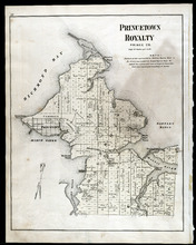
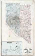
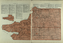
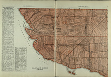
Princetown Royalty: Prince Co., P.E.I.
Description: The map shows Princetown Royalty, in Prince county. Shown are Bays, a basin, rivers, commons, sand, points, wharfs, churches, cemetery, post offices, roads, and landowners.
Publisher: J. H. Meacham & company
Province: Prince Edward Island
Type: cadastral maps
Date Issued (Source): 1880
Lots 60 and 62: Queens County
Description: The map shows lots 60 and 62 in Queens county. Shown are the Northumberland Strait, roads, railroads, harbour, points, landowners, and acreage.
Publisher: Cummins Map Co.
Province: Prince Edward Island
Type: cadastral maps
Date Issued (Source): 1927
Plan of Lot Thirty One: Queens Co., P.E.I.
Description: The map shows lot 31 in Queens county. Shown are rivers, landowners and acreage, post offices, creeks, railroads and stations, roads, churches, a ferry, and school houses. Compass. Illustrated… more
Publisher: J. H. Meacham & company
Province: Prince Edward Island
Type: cadastral maps
Date Issued (Source): 1880
Rural Directory - Lots 60 and 62, Queens County
Description: A directory listing of residents of lots 60 and 62.
Publisher: Cummins Map Co.
Province: Prince Edward Island
Type: text
Date Issued (Source): 1927
Rural Directory - Lots 35 and 36, Queens County
Description: A directory listing of residents of lots 35 and 36.
Publisher: Cummins Map Co.
Province: Prince Edward Island
Type: text
Date Issued (Source): 1927
Lots 35 and 36: Queens County
Description: The map shows lots 35 and 36 in Queens County. Shown are Hillsborough River, Tracadie Bay, Gulf of St. Lawrence. Mill Cove, landowners, acreage, raods, and railroads.
Publisher: Cummins Map Co.
Province: Prince Edward Island
Type: cadastral maps
Date Issued (Source): 1927
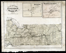
Plan of Lot Nineteen: Prince Co., P.E.I.
Description: The map shows lot 19 in Prince county. Shown are creeks, bays, roads, railroads and stations, landowners and acerage, post offices and buildings. Compass.
Publisher: J. H. Meacham & company
Province: Prince Edward Island
Type: cadastral maps
Date Issued (Source): 1880
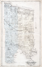
Lot 37, Queens County: Lot 38 Kings County
Description: The map shows lot 37 in Queens county and lot 38 in Kings county. Shown are the Gulf of St. Lawrence, Savage Harbour, landowners, acreage, roads, railroads, and rivers.
Publisher: Cummins Map Co.
Province: Prince Edward Island
Type: cadastral maps
Date Issued (Source): 1927
Plan of Lots 33 & 34: Queens Co., P.E.I.
Description: The map shows lots 33 (coloured in blue) & 34 (coloured in pink) in Queens county. The map shows roads, railroads and stations, landowners and acreage, farms, post offices, churches, hotels,… more
Publisher: J. H. Meacham & company
Province: Prince Edward Island
Type: cadastral maps
Date Issued (Source): 1880
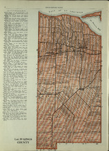
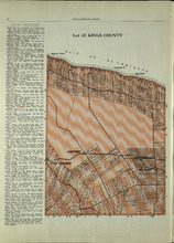
Lot 39: Kings County
Description: The map shows lot 39 in Kings county. Shown are the Gulf of St. Lawrence, St. Peters bay, landowners, acreage, roads, railroads, Stukeley Ponds, and sands hills.
Publisher: Cummins Map Co.
Province: Prince Edward Island
Type: cadastral maps
Date Issued (Source): 1927
Plan of Lot Eighteen: Prince Co., P.E.I.
Description: The map shows lot 18 in Prince county. Shown are bays, capes, points, coves, post offices, schools, creeks, mills, churches, landowners and acreage, and roads. Compass.
Publisher: J. H. Meacham & company
Province: Prince Edward Island
Type: cadastral maps
Date Issued (Source): 1880
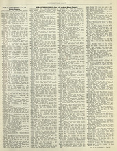
Rural Directory - Lot 39, Kings County : Rural Directory - Lots 40 - 41, Kings County
Description: A directory listing of residents of Lots 39, 40, and 41.
Province: Prince Edward Island
Date Issued (Source): 1927
Lots 40 and 41: Kings County
Description: The map shows lots 40 and 41 in Kings county. Shown are the Gulf of St. Lawrence, St. Peters Bay, landowners, acreage, roads, and railroads.
Publisher: Cummins Map Co.
Province: Prince Edward Island
Type: cadastral maps
Date Issued (Source): 1927
Plan of Lot Thirty Five & Thirty Six: Queens Co., P.E.I.
Description: The map shows lots 35 & 36 in Queens county. Shown are gulfs, bays, sand, coves, wharfs, rivers, ponds, creeks, fishing houses, roads, landowners and acreage, post offices, school houses,… more
Publisher: J. H. Meacham & company
Province: Prince Edward Island
Type: cadastral maps
Date Issued (Source): 1880
Lot 42: Kings County
Description: The map shows lot 42 in Kings county. Shown are the Gulf of St. Lawrence, points, landowners, acreage, roads, and railroads.
Publisher: Cummins Map Co.
Province: Prince Edward Island
Type: cadastral maps
Date Issued (Source): 1927
Rural Directory - Lots 42 - 44, Kings County
Description: A directory listing of residents of lots 42, 43, and 44
Publisher: Cummins Map Co.
Province: Prince Edward Island
Type: text
Date Issued (Source): 1927
Plan of Lot Thirty Two: Queens Co., P.E.I.
Description: The map shows lot 32 in Queens county. Shown are roads, landowners and acreage, railroad and station, post offices, rivers, churches, and coves. Compass.
Publisher: J. H. Meacham & company
Province: Prince Edward Island
Type: cadastral maps
Date Issued (Source): 1880
Lots 43 and 44 : Kings County
Description: The map shows lots 43 and 44 in Kings county. Shown are the Gulf of St. Lawrence, bays, points, rivers, landowners, acreage, roads, and railroads.
Publisher: Cummins Map Co.
Province: Prince Edward Island
Type: cadastral maps
Date Issued (Source): 1927

Plan of Lot Thirty Seven : Plan of Lot Thirty Eight: Queens Co., P.E.I.. Kings Co., P.E.I.
Description: The map shows lot 37 (coloured in pink) in Queens county, and lot 38 (coloured in blue) in Kings county. Shown are roads, railroads, landowners and acreage, rivers, ponds, harbours, gulfs, creeks,… more
Publisher: J. H. Meacham & company
Province: Prince Edward Island
Type: cadastral maps
Date Issued (Source): 1880
Rural Directory - Lot 51, 52, and 66, Kings County
Description: A directory listing of residents of lot 51, 52, and 66
Publisher: Cummins Map Co.
Province: Prince Edward Island
Type: text
Date Issued (Source): 1927
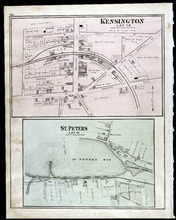
Kensington, Lot 19: St. Peters, Lot 41
Description: The map shows lot 19 in Kensington. Shown are a school house, a hall, roads, landowners, railroad and depot grounds, businesses and churches. Compass.
Publisher: J. H. Meacham & company
Province: Prince Edward Island
Type: cadastral maps
Date Issued (Source): 1880
Lot 45: Kings County
Description: The map shows lot 45 in Kings county. Shown are the Gulf of St. Lawrence, Colville bay, landowners, acreage, roads, and railroads.
Publisher: Cummins Map Co.
Province: Prince Edward Island
Type: cadastral maps
Date Issued (Source): 1927
Lots 46 and 47 : Kings County
Description: The map shows lots 46 and 47 in Kings county. Shown are the Gulf of St. Lawrence, points, rivers, coves, landowners, acreage, roads, railroads, lakes, and sand.
Publisher: Cummins Map Co.
Province: Prince Edward Island
Type: cadastral maps
Date Issued (Source): 1927
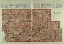
Plan of Lots Fourty Three & Fourty Four: Kings Co., P.E.I.
Description: The map shows lots 43 & 44 in Kings county. Shown are bays, gulfs, rivers, coves, capes, roads, railroads and stations, landowners and acreage, crosses, post offices, churches, and factories.… more
Publisher: J. H. Meacham & company
Province: Prince Edward Island
Type: cadastral maps
Date Issued (Source): 1880
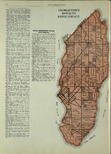
Georgetown Royalty: Kings County
Description: The map shows Georgetown Royalty in Kings county. Shown are landowners, acreage, Brudenell and Cardigan River, Albion Bay, roads, and railroads.
Publisher: Cummins Map Co.
Province: Prince Edward Island
Type: cadastral maps
Date Issued (Source): 1927
Lots 51, 52, and 66: Kings County
Description: The map shows lots 51, 52, and 66 in Kings County. Shown are Brown Creek, Montague River, Landowners, acreage, roads, and railroads.
Publisher: Cummins Map Co.
Province: Prince Edward Island
Type: cadastral maps
Date Issued (Source): 1927