Displaying 433 - 486 of 603
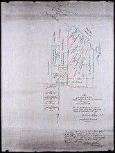
Plan of Part of Township no 35 on Bedford Bay
Description: Plan of part of Lot 35 (No.631) bordering on Bedford Bay. The map shows lots, residents, roads, and various bodies of water.
Province: Prince Edward Island
Type: cadastral maps
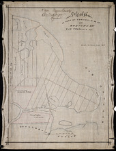
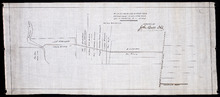
Plan of Part of Township No. 35 on the North Side of the Hillsborough River
Description: Plan of part of Lot 35 on the north side of the Hillsborough River. The map shows lots, residents, roads, Bedford Bay and foliage.
Province: Prince Edward Island
Type: cadastral maps
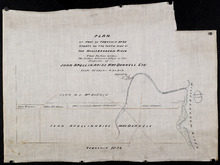
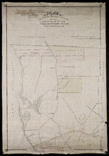
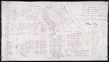
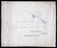
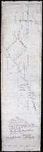
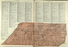
Plan of Part of Township No. 35 situate on the South Side of the Hillsborough River
Description: Plan of part of Lot 35 situate on the south side of the Hillsborough River. The property of John Apollinarius MacDonnell. Plan copied by R.T. Weeks. The map shows lots, residents, roads, islands, and… more
Province: Prince Edward Island
Type: cadastral maps
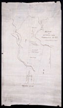
Plan of St Martins Township No 35
Description: Plan of part of Lot 35, St. Martins. The map shows lots, residents, and bodies of water such as rivers.
Province: Prince Edward Island
Type: cadastral maps
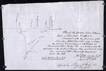
Plan if the Southren Moiety of Township No 36 Part of the Estate of the Rev: John Alister Somerlet…
Description: Plan of the southern moiety of Lot 36 (No.2). Part of the estate of the Rev. John Alister Somerlet MacDonald. From a tracing by W.C. Harris. The map shows lots, residents, a pond, and roads.
Province: Prince Edward Island
Type: cadastral maps
Date Created: 1878-03-22
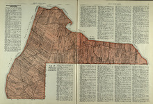
Plan of Lot 37
Description: Plan of Lot 37, north of the Hillsborough River. Shows some residents, lots, roads, and bodies of water.
Province: Prince Edward Island
Type: cadastral maps
Surveyor General's Plan for south western half of Lot 37
Description: Surveyor General's Plan for south western half of Lot 37 (No.1). The map shows lots, residents, and bodies of water. more
Province: Prince Edward Island
Type: cadastral maps
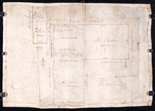
Plan of part of Lot 38
Description: Plan of part of Lot 38 (No.7). Part of Mrs. Burns' property, sold to LeLacheur and others. The map shows lots, and residents. more
Province: Prince Edward Island
Type: cadastral maps
Plan of the estates of the late Angus McDonald and James McDonald at Springfield Township No 39:…
Description: Part of Lot 39. Plan of the estates of the late Angus McDonald and James McDonald at Springfield. Also the subdivisions of the same as agreed upon at the time of survey. The map shows lots, residents… more
Province: Prince Edward Island
Type: cadastral maps
Date Created: 1910-09
Plan of the division line between Lots 59 and 61, surveyed under the provisions of the Boundary…
Description: Plan of the division line between Lots 59 and 61, surveyed under the provisions of the Boundary Bill 4 William 4 Cap.15. This copy is taken from an original plan created 15 August 1838 by surveyor… more
Province: Prince Edward Island
Type: cadastral maps
Date Created: 1838-08-15
Date Modified: 1908-02
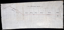
Plan of the division line between Lots 48 and 49
Description: Plan of the division line between Lots 48 and 49. The map shows lots, residents, roads, and bodies of water.
Province: Prince Edward Island
Type: cadastral maps
Date Created: 1841-06
Plan of the division line between Lots 31 and 65, the commencement of which was set by the…
Description: Plan of the division line between Lots 31 and 65, the commencement of which was set by the Commissioners for establishing boundary lines. (No.1) The map shows lots, roads, and rivers.
Province: Prince Edward Island
Type: cadastral maps
Date Created: 1837-08-26
Royalty of Charlotettown
Description: Plan showing the line dividing Lots 33 and 34. (No.10). The map shows lots, residents, roads, and bodies of water.
Province: Prince Edward Island
Type: cadastral maps
Plan showing the point of commencement of the division line between Lots 48 and 49, established by…
Description: Plan showing the point of commencement of the division line between Lots 48 and 49, established by the Commissioners under the Boundary Bill, July 30, 1840. The map shows lots, residents, roads,… more
Province: Prince Edward Island
Type: cadastral maps
Date Created: 1840-08
Plan of a New Road from the Flat River Road (marked A, B, C, D, E, F.) to the shore of the straits…
Description: Plan of a New Road from the Flat River Road to the shore of the straits. On Lots 60 and 62. The map shows lots, residents, roads, and water.
Province: Prince Edward Island
Type: cadastral maps
Plan shewing the situation of a new line of road from Baldwin's Road, Lot 51 to Brother's…
Description: Plan showing the situation of a new line of road from Baldwin's Road, Lot 51 to Brother's Road, Lot 66 more
Province: Prince Edward Island
Type: cadastral maps
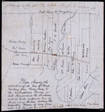
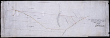
Plan shewing the situation of the line of road leading from Cherry Valley to the contemplated…
Description: Plan showing the situation of the line of road leading from Cherry Valley to the contemplated bridge on Seal River and the 24 chains and 50 links unopened line of road along the line between the… more
Province: Prince Edward Island
Type: cadastral maps
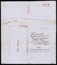
Plan of part of the Georgetown Road on Lot 51 showing the encrouchment by John Curran from a survey…
Description: Plan of part of the Georgetown Road on Lot 51. Shows Union Road and property of John Curran. (No.3) The map shows lots, resident, and roads.
Province: Prince Edward Island
Type: cadastral maps
Date Created: 1908-06-04
Plan of the road from Kelly's Cove to the line between John F. Baker and Frank Bovyer thro…
Description: Plan of the road from Kelly's Cove to the line between John F. Baker and Frank Bovyer through Bunbury, Lot 48. Ordered to be widened. The map shows lots, residents, roads, and water. more
Province: Prince Edward Island
Type: cadastral maps
Plan of proposed new road straightening Rollo Bay Road, through the farms of Chas. Townshend and…
Description: Plan of proposed new road straightening Rollo Bay Road, through the farms of Chas. Townshend and Jos. Webster. The map shows lots, residents, and roads.
Province: Prince Edward Island
Type: cadastral maps
Proposed New Road from Rustico Road to Brookfield Road
Description: Proposed New Road from Rustico Road to Brookfield Road. The map shows lots, roads, residents, and a swamp.
Province: Prince Edward Island
Type: cadastral maps
Plan showing the position of 2 new lines of road from R. McMillan's Mills to Fredericton…
Description: Plan showing the position of 2 new lines of road from R. McMillan's Mills to Fredericton Station. Also through McMillan's land from French Settlement. Also from Trout River Bridge to Road… more
Province: Prince Edward Island
Type: cadastral maps

Plan of a proposed new line of road from Middleton Road to Isaac Ive's Millas coloured brown…
Description: Plan of a proposed new line of road from Middleton Road to Isaac Ive's Mill connecting with the road already opened from Searletown to Ive's Mill thro. part of Lot 27. The map shows lots,… more
Province: Prince Edward Island
Type: cadastral maps
Plan Shewing the Situation of the Presen road from Point Prim Also the proposed road A.B.C.orD.
Description: Plan showing the situation of the present road from Point Prim. Also, the proposed one. The map shows lots, residents, water and foliage.
Province: Prince Edward Island
Type: cadastral maps
Plan of a new line of road from Victoria West to Western Road Lot 13 Prince Co. P.E.Island
Description: Plan of a new line of road from Victoria West to Western Road. Lot 13. The map shows lots, residents, roads, and rivers.
Province: Prince Edward Island
Type: cadastral maps
Plan of part of the Linklater Road, Lot 17
Description: Plan of part of the Linklater Road, Lot 17. (Linkletter Road) The map shows lots, residents, and roads.
Province: Prince Edward Island
Type: cadastral maps
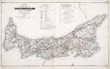
Province of Prince Edward Island, Canada: Cummins Map Co. Toronto
Description: The map shows all of Prince Edward Island and some of New Brunswick and Nova Scotia. Shown through a table of Counties are bays, roads, marshes, rapids, Indian Reserves, Lighthouses, depth of water,… more
Publisher: Cummins Map Co.
Province: Prince Edward Island
Type: cadastral maps
Date Issued (Source): 1927
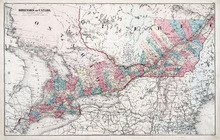
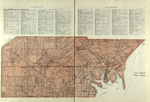
Dominion of Canada: (Western Sheet)
Description: Map showing the province of Ontario, and Quebec. Shows rivers, lakes, channels, bays, roads, railroads, cities, towns, copper mines, and sea measurements. Ontario and Quebec are coloured and cities… more
Publisher: J. H. Meacham & company
Province: Ontario, Quebec, Prince Edward Island, Michigan, New York, Ohio
Type: cadastral maps
Date Issued (Source): 1880
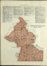
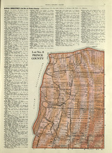
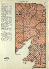
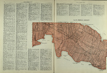
Princetown Royalty: Prince County
Description: The map shows Princetown Royalty in Prince County. Shown are rivers, bays, roads, landowners, acreage, and towns. Atlas of Province of Prince Edward Island, Canada and the World
Publisher: Cummins Map Co.
Province: Prince Edward Island
Type: cadastral maps
Date Issued (Source): 1927
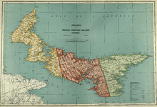
Map of the Province of Prince Edward Island: in the Gulf of St. Lawrence
Description: The map shows the province of Prince Edward Island. Shown are tables of Explanations and Electorial Districts, a compass and the county lines are marked in red. Shown are gulfs, straits, bays, reefs… more
Publisher: J. H. Meacham & company
Province: Prince Edward Island
Type: cadastral maps
Date Created: 1880
Date Issued (Source): 1880
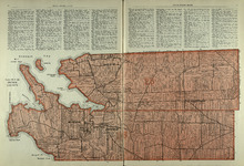
Lots 2 & 3 : Prince County
Description: The map shows lots 2 & 3 in Prince county. Shown are the Gulf of St. Lawrence, capes, ponds, landowners, acreage, rivers, and roads.
Publisher: Cummins Map Co.
Province: Prince Edward Island
Type: cadastral maps
Date Issued (Source): 1927
Lots 4 : Prince county
Description: The map shows Lots 4
Publisher: Cummins Map Co.
Province: Prince Edward Island
Type: cadastral maps
Date Issued (Source): 1927

Plan of Lot One: Prince Co., P.E.I.
Description: Map showing the northWestern tip of the island. It names the gulfs, rivers, ponds, landowners and acreage, roads, and railroads. A graphic compass.
Publisher: J. H. Meacham & company
Province: Prince Edward Island
Type: cadastral maps
Date Issued (Source): 1880
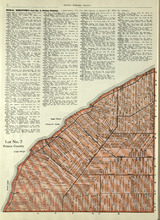
Lot No. 7: Prince County
Description: The map shows Lot 7 in Prince county. Shown are capes, coves, roads, landowners, and acreage.
Publisher: Cummins Map Co.
Province: Prince Edward Island
Type: cadastral maps
Date Issued (Source): 1927

Plan of Lot Six: Prince Co., P.E.I.
Description: Map showing lot six, bordering lots 5, 9, 10, 11 in Prince county. Shows rivers, creeks, railroads, roads, landowners, acreage, post offices, and buildings. Geographical compass
Publisher: J. H. Meacham & company
Province: Prince Edward Island
Type: cadastral maps
Date Issued (Source): 1880
Lot No. 8: Prince County
Description: The map shows Lot 8 in Prince County. Shown are the Nothumberland Strait, Wolf Inlet, Landowners, acreage, and roads.
Publisher: Cummins Map Co.
Province: Prince Edward Island
Type: cadastral maps
Date Issued (Source): 1927

Plan of Lots Two : Prince Co., P.E.I.
Description: Map showing lots 2
Publisher: J. H. Meacham & company
Province: Prince Edward Island
Type: cadastral maps
Date Issued (Source): 1880

Lot No. 9: Prince County
Description: The map shows Lot 9 in Prince county. Shown are roads, Egmont Bay, Dog Cove, roads, and railroads.
Publisher: Cummins Map Co.
Province: Prince Edward Island
Type: cadastral maps
Date Issued (Source): 1927

Plan of Lot Seven: Prince Co., P.E.I.
Description: Map showing lot seven, bordering lots 4, 5, 6, and 8 in Prince county. Shows gulfs, railroads, roads, landowners, acreage, post offices, and buildings. Geographical compass
Publisher: J. H. Meacham & company
Province: Prince Edward Island
Type: cadastral maps
Date Issued (Source): 1880

Tignish, Prince Co.: Campbellton
Description: The map shows Lot 1 in Tignish, Prince county. Shown are roads, landowners and acreage, a church, chapel, and convent, a cemetery, railroad and station, grammar school, business, and houses. Compass.
Publisher: J. H. Meacham & company
Province: Prince Edward Island
Type: cadastral maps
Date Issued (Source): 1880
Lot 10: Prince County
Description: The map shows Lot 10 in Prince county. Shown are rivers, roads, landowners, and acreage.
Publisher: Cummins Map Co.
Province: Prince Edward Island
Type: cadastral maps
Date Issued (Source): 1927
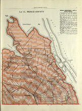
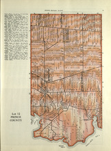
Lot 11: Prince County
Description: The map shows lot 11 in Prince county. Shown are roads, landowners, acreage, the Gulf of St. Lawrenece, Sand Hills, The Narrows, Cascumpeque Baym Foxley River, and Cavendish Inlet.
Publisher: Cummins Map Co.
Province: Prince Edward Island
Type: cadastral maps
Date Issued (Source): 1927
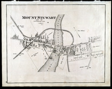
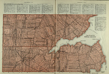
Mount Stewart: Lot 37
Description: The map shows lot 37 in Mount Stewart. Shown are roads, railroads and depot, landowners, houses, churches, Hillsborough river, wharfs, halls, and shipyard. Compass.
Publisher: J. H. Meacham & company
Province: Prince Edward Island
Type: cadastral maps
Date Issued (Source): 1880
Lot 12: Prince County
Description: The map shows Lot 12 in Prince county. Shown are roads, landowners, acreage, The Narrows, rivers, and a railroad.
Publisher: Cummins Map Co.
Province: Prince Edward Island
Type: cadastral maps
Date Issued (Source): 1927

Plan of Lot Four : Prince Co., P.E.I.
Description: Map showing lots four
Publisher: J. H. Meacham & company
Province: Prince Edward Island
Type: cadastral maps
Date Issued (Source): 1880
Lot 15: Prince County
Description: The map shows lot 15 in Prince county. Shown are Red Head, Cape Egmont, Egmont Bay, the Northumberland Strait, rivers, landowners, acreage, and roads.
Publisher: Cummins Map Co.
Province: Prince Edward Island
Type: cadastral maps
Date Issued (Source): 1927

Plan of Lot Eight: Prince Co., P.E.I.
Description: The map shows lot 8 in Prince county. Shown are roads, landowners and acreage, rivers, Northumberland strait, ponds, lighthouses, post offices, churches, mills, and businesses. Compass.
Publisher: J. H. Meacham & company
Province: Prince Edward Island
Type: cadastral maps
Date Issued (Source): 1880
Lots 14 and 16 : Prince County
Description: The map shows lots 14 and 16, in Prince county. Shown are bays, ponds, coves, landowners, acreage, rivers, and roads.
Publisher: Cummins Map Co.
Province: Prince Edward Island
Type: cadastral maps
Date Issued (Source): 1927

Plan of Lot Thirteen: Prince Co., P.E.I.
Description: Map showing lot thirteen, bordering lots 12, 14 and 15, in Prince county. Shows gulfs, straits, bays, rivers, ponds, creeks, railroads, roads, landowners, acreage, post offices, and buildings.… more
Publisher: J. H. Meacham & company
Province: Prince Edward Island
Type: cadastral maps
Date Issued (Source): 1880
Lot 17: Prince County
Description: The map shows Lot 17 in Prince county. Shown are byas, coves, landowners, acreage, towns, cities, and roads.
Publisher: Cummins Map Co.
Province: Prince Edward Island
Type: cadastral maps
Date Issued (Source): 1927

Plan of Lot Nine: Prince Co., P.E.I.
Description: The map shows lot 9 in Prince county. Shown are roads, landowners and acreage, Egmont bay, sand, Brae river, post offices, railroad and station, schools and churches. Compass.
Publisher: J. H. Meacham & company
Province: Prince Edward Island
Type: cadastral maps
Date Issued (Source): 1880

Plan of Lot Fourteen & Sixteen : Prince Co., P.E.I.
Description: Map shows lots fourteen & sixteen in Prince county. Shown are roads, creeks, coves, rivers, post offices, railroads and stations, ferries, points, bays, landowners, acreage, churches, and… more
Publisher: J. H. Meacham & company
Province: Prince Edward Island
Type: cadastral maps
Date Issued (Source): 1880

Plan of Lot Ten: Prince Co., P.E.I.
Description: The map shows lot 10 in Prince county. Shown are roads, rivers and creeks, railroad and station, post offices, a school, and landowners and acreage. Compass.
Publisher: J. H. Meacham & company
Province: Prince Edward Island
Type: cadastral maps
Date Issued (Source): 1880
Lots 25 & 26 : Prince County
Publisher: Cummins Map Co.
Type: cadastral maps
Date Issued (Source): 1927