Displaying 163 - 216 of 603
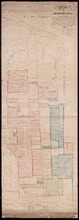
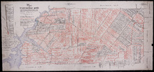
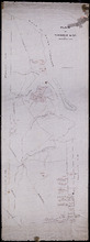
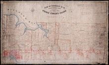
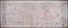
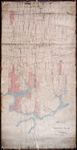
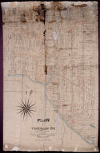
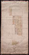
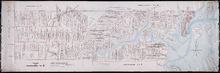
Plan of Township No. 33. in Prince Edward Island.: referred to in the Deed of Partition [...]
Description: Plan of Lot 33 referred to in the Deed of Partition between Alfred Winsloe, Henry Winsloe, Sydney T. Evans and wife, and Anne Winsloe, March 13, 1863. Shows names of residents and acreage, bodies of… more
Province: Prince Edward Island
Type: cadastral maps
Date Created: 1863-03-13
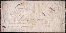
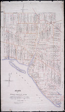
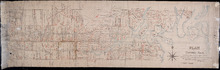
Plan of Lot 32 (No.86).: Cunard Estate.
Description: Plan of Lot 32 (No.86). Cunard Estate. Shows names of residents, acreage, and some land conveyance references, bodies of water such as creeks and rivers, and roads. Copied by Owen Curtis.
Province: Prince Edward Island
Type: cadastral maps
Date Created: 1876-07

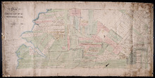
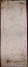
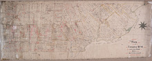
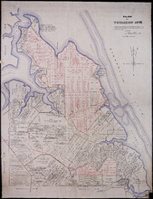
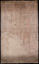
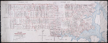
Plan of Township No. 32: compiled from the proprietors plans and Meacham's Atlas and from the…
Description: The map shows Lot 32 divided into parcels of land with names of residents, acreage amounts and land conveyance references. Areas drawn in black indicate government land; areas in red indicate… more
Province: Prince Edward Island
Type: cadastral maps
Date Created: 1919-01
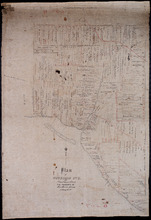
Plan of Township No. 32 situate in the Parish of Charlotte, Queens County, P. E. Island: Scale 20…
Description: Plan of Lot 32 (No.85). One of the plans referred to in the Deed from Sir Edward, William, and Laura Cunard to the Commissioner of Public Lands, July 13, 1866. Shows names of residents, acreage, and… more
Province: Prince Edward Island
Type: cadastral maps
Date Created: 1849
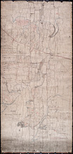
Plan of Township No. 31 in Prince Edward Island
Description: Plan of Lot 31 from H.J. Cundall, one of the Trustees of the Wm. Douse Estate (Death of Wm. Douse in 1864). Shows names of residents, acreages, and some land conveyance references, bodies of water… more
Province: Prince Edward Island
Type: cadastral maps
Plan of Township No. 31: compiled from the proprietors plans and Meacham's Atlas and from the…
Description: Plan of Lot 31 compiled from the Proprietors' plans and Meacham's Atlas and from the descriptions in leases and registered deeds, with additions and corrections from various surveys made… more
Province: Prince Edward Island
Type: cadastral maps
Date Created: 1917-12
Titles to Lot 31
Description: Plan of Lot 31 (No.84). Douse Estate. Shows names of some residents, some acreage, some land conveyance references, roads, and a nautical compass.
Province: Prince Edward Island
Type: cadastral maps
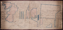
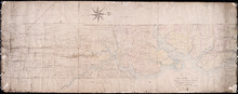
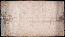
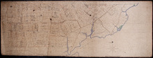
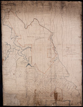
Plan of the East Moriety of Lot or Township No 29: part of the Estate of Lord Vicount Melville…
Description: Plan of the east moiety of Lot 29 (No.79). Part of the estate of Lord Viscount Melville. Shows names of residents, acreage, and a few land conveyance references, bodies of water such as the… more
Province: Prince Edward Island
Type: cadastral maps
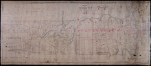
Plan of Township No. 26: Embracing the Thomson Holland and Stephens Estates
Description: Plan of Lot 26 embracing the Thomson, Holland, and Stephens Estates. Shows names of residents, acreage, and land conveyance references, bodies of water such as river, cove, and pond, roads, and a… more
Province: Prince Edward Island
Type: cadastral maps
Plan of the North Moriety of a Township No. 26 the Property if the Messrs Thompson of Belfast…
Description: Plan of the North Moiety of Lot 26, the property of the Messrs. Thompson of Belfast Ireland. Shows names of residents, acreage, and a few land conveyance references, bodies of water such as Bedeque… more
Province: Prince Edward Island
Type: cadastral maps
Date Created: 1875-11-05
Plan "A" Part of Township No. 24: as divided amongst the children of the late Alfred…
Description: Plan "A" part of Lot 24 as divided amongst the children of the late Alfred Winsloe (No.64). Shows names of residents and acreage, bodies of water such as rivers, creeks, roads, and a… more
Province: Prince Edward Island
Type: cadastral maps
Date Created: 1872-06-11
Plan of Lot 24 (No.66): Part of the estate of John Hodges Winsloe
Description: Plan of Lot 24 (No.66). Part of the estate of John Hodges Winsloe. Shows names of residents, acreage, and a few land conveyance references, bodies of water such as Gulf of St. Laurence, rivers, roads… more
Province: Prince Edward Island
Type: cadastral maps
Date Created: 1847
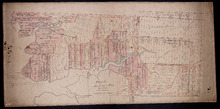
This is the Plan of Township No. 24 in Prince Edward Island
Description: Plan of Lot 24 showing the division of the Winsloe Estate. Shows names of residents and acreage, bodies of water such as gulfs, bays, creeks, rivers, sand hills, Rustico or Peter's Island and… more
Province: Prince Edward Island
Type: cadastral maps
Date Created: 1863-03-13
Plan of Township No. 24 in Prince Edward Island
Description: Plan of Lot 24. Smith Estate. Mainly outline but shows a few residents and acreage, bodies of water such as rivers, gulfs, bays and creeks, roads, sand hills, and Rustico or Peter's Island. more
Province: Prince Edward Island
Type: cadastral maps
Plan of the property of Mrs W.L. Smith : Situate on Township No. 24 in Prince Edward Island, Mrs L…
Description: Plan of the property of Mrs W.S. Smith. Situated on Lot 24. The maps shows bodies of water such as rivers and creeks, Rustico Island, roads, and a nautical compass.
Province: Prince Edward Island
Type: cadastral maps
Plan of Township No. 24 Situate in Grenville Parish. Queen's County. P.E.Island.: Complied…
Description: Plan of Lot 21 situate in Grenville Parish (No.54). Compiled from actual surveys. Cunard Estate. Shows names of residents and acreage, bodies of water such as gulfs, rivers, and creeks, roads, and a… more
Province: Prince Edward Island
Type: cadastral maps
Date Created: 1844
Plan of Lot Twenty One : Queens Co P.E.I.
Description: Plan of Lot 21 drawn from old maps, plans, and records. Shows names of residents, acreage, and land conveyance references, bodies of water such as bays, ponds, gulfs, and rivers, roads, and a… more
Province: Prince Edward Island
Type: cadastral maps
Date Created: 1952
Plan of part of Lot 19 (No.48)
Description: Plan of part of Lot 19 (No.48). Hodgson and Yeo Estates. Shows names of some residents, bodies of water such as bays, roads, division lines.
Province: Prince Edward Island
Type: cadastral maps
Plan of Township No. 16 in Prince Edward Island: The Property Of Miss Sullivan
Description: Plan of Lot 16 (No.44). The property of Miss Sullivan. Shows names of residents, bodies of water, roads, and a compass. Color code shows freehold lands purchased from the Proprietor and other… more
Province: Prince Edward Island
Type: cadastral maps
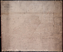
Plan of Township No. 19: Situate in Prince County The Property of A.T.Todd ESQ. Toronto, Prince…
Description: Plan of Lot 19, the property of A.T. Todd, Toronto. Plan referred to in the Indenture dated 11 November, 1871 between A.T. Todd and E.J. Hodgson. Plan also referred to in a conveyance from E.J.… more
Province: Prince Edward Island
Type: cadastral maps
Plan of Lot 14
Description: Plan of Lot 14 (No.40). Cunard Estate. Shows names of some residents, acreage, and a few land conveyance references. The map shows bodies of water such as Ellis (or Grand) River, and Cross River,… more
Province: Prince Edward Island
Type: cadastral maps
Date Created: 1847
Plan of Township No 14: Compiled from the proprietors' plans and Meacham's Atlas, and…
Description: Plan of Lot 14 compiled from the proprietors' plans and Meacham's Atlas, and from the descriptions in leases and deeds, with additions and corrections from the reports of various surveys on… more
Province: Prince Edward Island
Type: cadastral maps
Date Created: 1914

Plan of Lot or Township No 14 : Situate in the Parish of Richmond, Prince County P.E.Island
Description: Plan of Lot 14 situate in the Parish of Richmond. One of the plans referred to in the deed from Sir Edward, William, and Laura Cunard to the Commissioner of Public Lands, July 13, 1866. Shows names… more
Province: Prince Edward Island
Type: cadastral maps
Plan of Township No 14: part of the Cunard Estate.
Description: Plan of Lot 14 (No.39). Part of Cunard Estate. Shows names of residents, acreage, and some land conveyance references. The map shows bodies of water, roads, post offices, a railroad station, and a… more
Province: Prince Edward Island
Type: cadastral maps

Plan of Lot or Township of No. 13 in Prince County: Prince Edward Island
Description: Plan of Lot 13 (No.35). Yeo Estate. Shows names of residents, acreage, and some land conveyance references. Color code (orange, and yellow) shows willed land and freehold land. The map also shows… more
Province: Prince Edward Island
Type: cadastral maps
Date Created: 1875-10-09
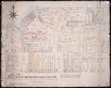
Plan of the Western End of Lot 13.: Corrected from recent Surveys, also shewing Leases, Ledger…
Description: Plan of the western end of Lot 13 (No.37). Yeo Estate. The map shows the western part of Lot 13 divided into parcels of land with names of residents, their acreage amounts and land conveyance… more
Province: Prince Edward Island
Type: cadastral maps
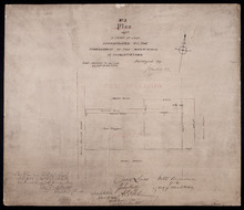
Plan of Township No. 12: Copied from Survey by John Ball L.S. by Thos Mackinlay
Description: Plan of Lot 12 (No.34). Stewart Estate. Copied from survey of John Ball by Thos. MacKinlay. Shows names of residents, acreage, and land conveyance references. The map shows bodies of water, Lennox (… more
Province: Prince Edward Island
Type: cadastral maps
Plan of Township No. 12
Description: Plan of Lot 12 (No.33). Stewart Estate. Shows names of residents and some acreage and land conveyance references. The map shows bodies of water, roads, a railroad station, and Lennox Island.
Province: Prince Edward Island
Type: cadastral maps
Plan of Part of Lot or Township Number Eleven: by A. Anderson, 1847
Description: Plan of part of Lot 11 (No.31). Stewart Estate. Shows names and acreage of some residents, bodies of water such as rivers, roads, and a compass.
Province: Prince Edward Island
Type: cadastral maps
Date Created: 1847
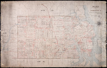
Plan of Township No. 11: compiled from the plans by the late Alexander Anderson L. S on file in the…
Description: The map shows Lot 11 divided into parcels of land with names of residents, their acreage amounts and land conveyance references. Shows the P.E.I. Railway in red, roads in light brown. Bodies of water… more
Province: Prince Edward Island
Type: cadastral maps
Date Created: 1910
Plan of Township Number 10. Surveyed by John Ball, L. S.
Description: Plan of Lot 10 (No.28). Stewart Estate. Shows names of residents, acreage, and a few land conveyance references, bodies of water such as rivers, lakes, bays, and creeks, roads, and Bird Island.
Province: Prince Edward Island
Type: cadastral maps
Plan of Township No. 9: Copied from plan furnished by Proprietress with alterations and additions…
Description: Plan of Lot 9 (No.26). Sullivan Estate. Copied from plan furnished by Proprietress with alterations and additions from surveys by Owen Curtis, John Clay &c. Shows names of residents, acreage, and… more
Province: Prince Edward Island
Type: cadastral maps
Date Created: 1883-08-18
Plan of Township No. 9: compiled from the proprietors' plans and the descriptions in the…
Description: Plan of Lot 9 compiled from the proprietors plans and the descriptions in the leases and deeds, with additions and corrections from the various surveys. The map shows Lot 9 divided into parcels of… more
Province: Prince Edward Island
Type: cadastral maps
Date Created: 1909
Lot 9
Description: Plan of Lot 9 (No.25). Sullivan Estate. Shows names of residents, acreage, and land conveyance references, rivers, roads, and Sandy or Brae Islands.
Province: Prince Edward Island
Type: cadastral maps
Plan of Township No. 9 in Prince Edward Island: The Property of Miss Charlotte Sullivan containing…
Description: Plan of Lot 9 (No.27). The property of Miss Charlotte Sulivan, containing 17300 acres. Shows names of residents and acreage, bodies of water such as rivers, creeks, roads, Sandy or Brae Island, and… more
Province: Prince Edward Island
Type: cadastral maps
Lot 8
Description: Plan of the eastern part of Lot 8 (No.24). Ramsay Estate. Shows names of some residents, acreage, and some land conveyance references, rivers, roads, and sand hills.
Province: Prince Edward Island
Type: cadastral maps
Plan of Township No. 7, Prince County, Prince Edward Island, From Actual Survey by John Clay L. S…
Description: Plan of Lot 7 (No.21). Stewart Estate. Shows names of residents and acreage, bodies of water such as the Gulf of St. Lawrence, ponds, and roads.
Province: Prince Edward Island
Type: cadastral maps
Date Created: 1877-04-09
Plan of Township No. 6: Compiled from plans, leases, deeds, and other documents on file in the Land…
Description: The map shows Lot 6 divided into parcels of land with names of residents, their acreage amounts and land conveyance references handwritten in black and red ink. Shows the P.E.I. Railway in red, roads… more
Province: Prince Edward Island
Type: cadastral maps
Date Created: 1912-01
Plan of Town Lots at Cascumpec Point. Township No. 5.: Compiled and corrected from Surveys by John…
Description: Plan of Town Lots at Cascumpec Point, Lot 5. The map shows Cascumpec Point divided into parcels of land (most of them numbered) with names of residents. Shows land belonging to J. C. Pope outlined in… more
Province: Prince Edward Island
Type: cadastral maps
Date Created: 1877-08-01
Plan of Township No. 5: compiled from plans, leases, deeds, and other documents on file in the Land…
Description: Plan of Lot 5 compiled from plans, leases, deeds, and other documents on file in the Land Office. The map shows Lot 5 divided into parcels of land with names of residents, their acreage amounts and… more
Province: Prince Edward Island
Type: cadastral maps
Date Created: 1911-09
Plan of Lot or Township No. 5 in Prince Edward Island: The Shore and the Division line, coloured…
Description: Plan of Lot 5. The Shore and the Division line, coloured Yellow are according to actual Survey by A. Anderson. Shows names of residents, acreage, and land conveyance references, bodies of water such… more
Province: Prince Edward Island
Type: cadastral maps
Date Created: 1840
Plan of Township No. 5: Copied from Plans in Land Office, with many addition and corrections from…
Description: Plan of Lot 5 (No.17). Cunard Estate. Copied from plans in Land Office with many additions and corrections from more recent surveys. Also sundry data connecting the lands with their ledger folios,… more
Province: Prince Edward Island
Type: cadastral maps
Date Created: 1886
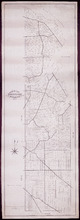
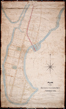
Plan of the subdivision of property owned by Mrs. John Longworth in the Commons of Charlottetown:…
Description: Plan of the subdivision of property owned by Mrs. John Longworth in the Commons of Charlottetown, Common Lot No.29. Plan made under the instructions of H.J. Palmer, Trustee for Mrs. John Longworth. (… more
Province: Prince Edward Island
Type: cadastral maps
Date Created: 1923-07-19
Part of Common Lot No. 22.
Description: Plan of part of Common Lot No.22, Charlottetown.
Province: Prince Edward Island
Type: cadastral maps
Date Created: 1886
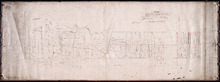
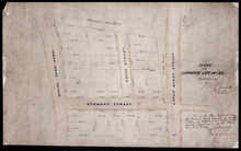
No. 3 Plan of a Tract of Land Appropriated by the Commissioners of the Water-works of Charlottetown
Description: Plan of a tract of land in Charlottetown Royalty appropriated by the Commissioners of the Water-works of Charlottetown. (No.3) (Also No.104). Also shown are landowners and acreage.
Province: Prince Edward Island
Type: cadastral maps
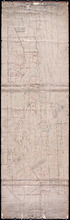
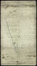
Reserved or Settlement road on Lot 5
Description: Plan of part of Lot 5. The farms on the north side of the Reserved or Settlement Road. The map shows 20 parcels of land on the north side of the Reserve or Settlement Road in the western portion of… more
Province: Prince Edward Island
Type: cadastral maps
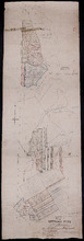
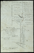
Plan Shewing the Situation of Plot No. 94 on Lot or Township No. 15
Description: Plan of part of Lot 15 (No.74). Shows the situation of Plot No.94, the property of John MacInally. 77 acres. MacInally's plot is shaded green. Map also shows Joseph Gallant's Plot No. 93 to… more
Province: Prince Edward Island
Type: cadastral maps
Plan of 50 Acres of Land being half of Lot No. 171 in the Occupation of John Rechore in Township No…
Description: Plan of part of Lot 15. 50 acres of land, part of 171 in the occupation of John Rechore. Also shows (sub) lots 170, 172, 173 and 174. Copied from office plan of Lot 15. (No.3)
Province: Prince Edward Island
Type: cadastral maps
Date Created: 1851-06-03
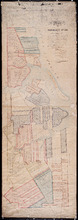
Plan Shewing the position of Common Lot No. 18: from actual survey by Joseph Ball
Description: Plan of the part of Charlottetown showing the position of Common Lot No. 18 on the west side of West Street. Gives names of residents on that side of the street. Shows numbered common lots in the… more
Province: Prince Edward Island
Type: cadastral maps
Part of Lot 18
Description: Plan of part of Lot 18 (No.6). Two Ramsay properties, each 100 acres in size, along Oyster Cove in Lot 18. Sandy and/or marshy areas shown with stippling/shading. North arrow.
Province: Prince Edward Island
Type: cadastral maps
Plan Shewing the Alteration of the West Settlement Road "as colored" together with the…
Description: Plan showing the alteration of the West Settlement Road together with the actual settlers on the same. Lot 22. The maps shows an alteration to a portion of the West Settlement Road in Lot 22. The… more
Province: Prince Edward Island
Type: cadastral maps
Date Created: 1870-03-01
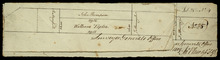
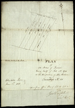
Part of Lot 25
Description: Plan of part of Lot 25 (No.4). Thompson-Taylor land. This item consists of 2 maps——on separate pieces of paper——of the parcels of land belonging to John Thompson (200 acres) and William Taylor (320… more
Province: Prince Edward Island
Type: cadastral maps
Date Created: 1809-11-20
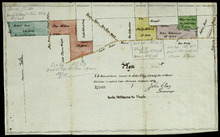
Plan of 75 Acres of land leased to John Clay, showing the different divisions in which it was…
Description: Plan of part of Lot 26. The plan shows 75 acres of land in the western part of Lot 26 leased to John Clay and then later divided and conveyed to other individuals. The plan shows names of residents… more
Province: Prince Edward Island
Type: cadastral maps
Date Created: 1878-08-05