Displaying 1 - 27 of 50

A plan of Charlottetown, the capital of the Island delineated by order of Walter Patterson,…
Description: A plan of Charlottetown, the capital of the Island delineated by order of Walter Patterson, Governor of the said Island (No.2). Includes Charlottetown Common and Royalty. Shows names of some… more
Province: Prince Edward Island
Type: cadastral maps

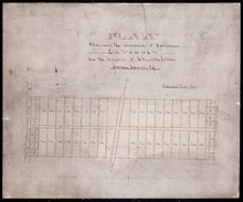
Plan of the Royalty of Charlottetown: from a survey taken in the year 1831 by Order of His…
Description: "Plan of the Royalty of Charlottetown from a survey taken in the year 1831 by Order of His Excellency Lieutenant Governor Ready." Shows Royalty Lot numbers, and acreage. (No.67) more
Province: Prince Edward Island
Type: cadastral maps
Date Created: 1831
Plan Shewing Lands in the Town, Common, and Royalty of Georgetown appropriated for Railway purposes…
Description: Plan showing lands in the Town, Common, and Royalty of Georgetown appropriated for Railway Purposes. The map shows residents, acreage, roads, and harbours.
Province: Prince Edward Island
Type: cadastral maps

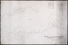
Plan Shewing Lands in the Common and Royalty of Charlottetown appropriated for Railway purposes.
Description: Plan showing land in the Common and Royalty of Charlottetown appropriated for Railway purposes. The map shows lots, acreage, roads, cities and towns.
Province: Prince Edward Island
Type: cadastral maps

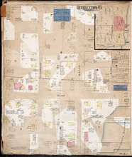
Plan of Charlotte Town Shewing the true position of the Streets and the encroachments thereon.…
Description: The map shows the street grid, numbered town lots and public squares of Charlottetown. It shows some buildings and some of the roads leading to/from the town.
Province: Prince Edward Island
Type: plans
Date Created: 1833


Royalty of Georgetown
Description: Plan of Lot 53 showing the estate of Lady Westmoreland. Shows names of residents and acreage, roads, and bodies of water such as rivers (Montague). Also shows the division line between the estate of… more
Province: Prince Edward Island
Type: cadastral maps
Plan Shewing the division of Pasture Lots Nos. 61, 62, 70 & 71 in the Royalty of Charlotte Town
Description: Plan showing the division of Pasture or Royalty Lots No.61, No.62, No.70 and No.71 in the Royalty of Charlottetown.
Province: Prince Edward Island
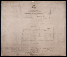
No. 3 Plan of a Tract of Land Appropriated by the Commissioners of the Water-works of Charlottetown
Description: Plan of a tract of land in Charlottetown Royalty appropriated by the Commissioners of the Water-works of Charlottetown. (No.3) (Also No.104). Also shown are landowners and acreage.
Province: Prince Edward Island
Type: cadastral maps
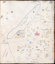
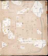
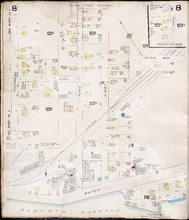
Charlottetown, P.E.I.: July, 1903
Description: This is Page 17 of 20 pages of fire insurance maps of Charlottetown. It was created in 1903 and revised to either 1910 or 1917. It shows an area bounded by Brighton Road and Euston Street to the… more
Publisher: Chas. E. Goad, Civil Engineer
Province: Prince Edward Island
Type: fire insurance maps
Date Created: 1903-07
Date Modified: 1910-08, 1917-07 (year and month uncertain)
Date Issued (Source): 1888
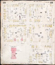
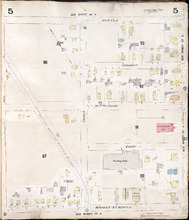
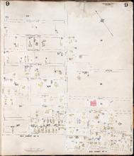
Charlottetown P.E.I.: July, 1903.
Description: This is Page 18 of 20 pages of fire insurance maps of Charlottetown. It was created in 1903 and revised to either 1910 or 1917. It shows the area from Euston Street to Grafton Street, between… more
Publisher: Chas. E. Goad, Civil Engineer
Province: Prince Edward Island
Type: fire insurance maps
Date Created: 1903-07
Date Modified: 1910-08, 1917-07 (year and month uncertain)
Date Issued (Source): 1888
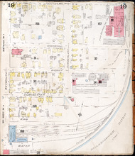
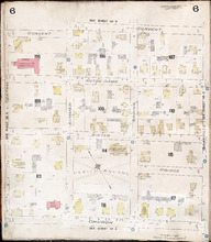
Charlottetown P.E.I.: July 1903
Description: This is Page 19 of 20 pages of fire insurance maps of Charlottetown. It was created in 1903 and revised to either 1910 or 1917. It shows the area from Grafton Street to Water Street, between Weymouth… more
Publisher: Chas. E. Goad, Civil Engineer
Province: Prince Edward Island
Type: fire insurance maps
Date Created: 1903-07
Date Modified: 1910-08, 1917-07 (year and month uncertain)
Date Issued (Source): 1888
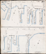
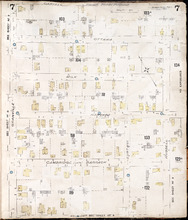
Charlottetown P.E.I.: July 1917. Reprinted.
Description: This is Page 20 of 20 pages of fire insurance maps of Charlottetown. It shows Water Street in two (2) sections that are intended to be continuous. The section at the top of the page shows Water… more
Publisher: Chas. E. Goad, Civil Engineer
Province: Prince Edward Island
Type: fire insurance maps
Date Created: 1917-07
Date Issued (Source): 1888
Georgetown P.E.I.
Description: This is the first of two pages of fire insurance maps of Georgetown. It was created in 1888, revised to 1897, and revised again to 1910. This page concentrates on an area one and a half blocks west… more
Publisher: Chas. E. Goad, Civil Engineer
Province: Prince Edward Island
Type: fire insurance maps
Date Created: 1888-10
Date Modified: 1897-11, 1910-09
Date Issued (Source): 1888
Georgetown P.E.I.: Oct. 1893
Description: This is the second of two (2) pages of fire insurance maps of Georgetown. It was created in 1893 and revised to 1910. The map concentrates on an area one and a half blocks east from West Street,… more
Publisher: Chas. E. Goad, Civil Engineer
Province: Prince Edward Island
Type: fire insurance maps
Date Created: 1893-10
Date Modified: 1910-09
Date Issued (Source): 1888

Summerside Prince Edward Island: Population: 3,500. July 1903
Description: This item, the first of 11 pages of fire insurance maps of Summerside, serves as the key plan for the other Summerside pages. It was created in 1903, revised to 1910, and then revised again to August… more
Publisher: Chas. E. Goad, Civil Engineer
Province: Prince Edward Island
Type: fire insurance maps
Date Created: 1903-07
Date Modified: 1910-10, 1917-08
Date Issued (Source): 1888

Summerside P.E.I.: Aug. 1917. Reprinted.
Description: This is Page 2 of 11 pages of fire insurance maps of Summerside. It shows the area from Market Street North to the waterfront, between Duke and Central streets. The map shows numbered town blocks and… more
Publisher: Chas. E. Goad, Civil Engineer
Province: Prince Edward Island
Type: fire insurance maps
Date Created: 1917-08
Date Issued (Source): 1888

Summerside, P.E.I.: Oct. 1910. Reprinted
Description: This is the older (1910) version of Page 3 of the Summerside fire insurance maps. The updated map of this town section is shown on Summerside_p3_1917. This map shows the area from Church Street to… more
Publisher: Chas. E. Goad, Civil Engineer
Province: Prince Edward Island
Type: fire insurance maps
Date Created: 1910-10
Date Issued (Source): 1888

Summerside P.E.I.: Aug 1917. Reprinted
Description: This is Page 3 of 11 pages of fire insurance maps of Summerside. This map shows the area from Church Street to the waterfront, between Central and Granville streets. The map shows numbered town… more
Publisher: Chas. E. Goad, Civil Engineer
Province: Prince Edward Island
Type: fire insurance maps
Date Created: 1917-08
Date Issued (Source): 1888

Summerside P.E.I.: July 1903.
Description: This is the older (1903, updated to 1910) version of Page 4 of the Summerside fire insurance maps. A more updated map of this town section is shown on Summerside_p4_1917. This map shows the area from… more
Publisher: Chas. E. Goad, Civil Engineer
Province: Prince Edward Island
Type: fire insurance maps
Date Created: 1903-07
Date Modified: 1910
Date Issued (Source): 1888

Summerside, P.E.I.: Aug. 1917. Reprinted
Description: This is Page 4 of 11 pages of fire insurance maps of Summerside. (An older version of this town section is shown on Summerside_p4_1910.) The map shows the area from Belmont Street to the waterfront,… more
Publisher: Chas. E. Goad, Civil Engineer
Province: Prince Edward Island
Type: fire insurance maps
Date Created: 1917-08
Date Issued (Source): 1888
Summerside, P.E.I.: July 1903
Description: This is Page 5 of 11 pages of fire insurance maps of Summerside. It was created in 1903 and revised to 1910. It shows the area from Myrtle Street to Market Street North, between Duke and Central… more
Publisher: Chas. E. Goad, Civil Engineer
Province: Prince Edward Island
Type: fire insurance maps
Date Created: 1903-07
Date Modified: 1910
Date Issued (Source): 1888
Summerside P.E.I.: July 1903.
Description: This is Page 6 of 11 pages of fire insurance maps of Summerside. It was created in 1903 and revised to 1910. It shows the area from Convent Street to Church Street, between Central and Granville… more
Publisher: Chas. E. Goad, Civil Engineer
Province: Prince Edward Island
Type: fire insurance maps
Date Created: 1903-07
Date Modified: 1910
Date Issued (Source): 1888
Summerside P.E.I.: July 1903.
Description: This is Page 7 of 11 pages of fire insurance maps of Summerside. It was created in 1903 and revised to 1910. It shows the area from Carvell Street to Belmont Street, between Granville and Russell… more
Publisher: Chas. E. Goad, Civil Engineer
Province: Prince Edward Island
Type: fire insurance maps
Date Created: 1903-07
Date Modified: 1910
Date Issued (Source): 1888
Summerside, P.E.I.: July 1903
Description: This is Page 8 of 11 pages of fire insurance maps of Summerside. It was created in 1903 and revised to 1917. It shows an area from the Kirk Street vicinity to the waterfront, east of Russell Street.… more
Publisher: Chas. E. Goad, Civil Engineer
Province: Prince Edward Island
Type: fire insurance maps
Date Created: 1903-07
Date Modified: 1917-08 (year and month uncertain)
Date Issued (Source): 1888
Summerside, P.E.I.: July 1903
Description: This is Page 9 of 11 pages of fire insurance maps of Summerside. It was created in 1903 and revised to either 1910 or 1917. It shows the area from Chestnut Avenue, in the north, to Myrtle and Convent… more
Publisher: Chas. E. Goad, Civil Engineer
Province: Prince Edward Island
Type: fire insurance maps
Date Created: 1903-07
Date Modified: 1910 (year uncertain)
Date Issued (Source): 1888
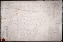
Plan of Ardgowan Estate in the Royalty of Charlotte Town
Description: Plan of Ardgowan Estate in the Royalty of Charlottetown as sold by auction, 26th June, 1879. Property of the Hon. J.C. Pope. (No.392). The map shows roads such as St. Peters, Confederation, lots,… more
Type: cadastral maps