Displaying 1 - 23 of 23

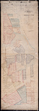
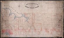
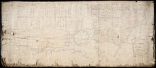
Plan of Lot 5
Description: Plan of Lot 5. Shows names of residents and acreage, rivers, creeks, roads, bays and Islands.
Province: Prince Edward Island
Type: cadastral maps

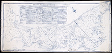
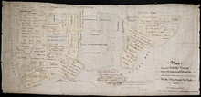
Plan of George Town: The Town Lots are 84 by 120 Feet. The North and South Streets are 100 Feet.…
Description: Plan of Georgetown showing lots and streets, bays, ranges, squares, and a school house. Also shows location of school house. Copy from the Office Plan No.6.
Province: Prince Edward Island
Date Created: 1853-06-07

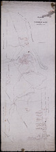
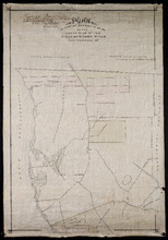
A Plan of Township No 4 Part of the Cunard Estate Prince County P.E.Island
Description: A plan of Lot 4, part of the Cunard Estate. Copied from plans in the Public Lands Department. The map shows lots, residents, bodies of water such as rivers, railways, and roads.
Province: Prince Edward Island
Type: cadastral maps
Date Created: 1885-06
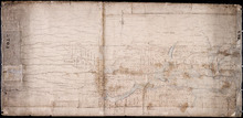
A Plan of the Island St. John in the Gulf of St. Lawrence in the Province of Nova Scotia in North…
Description: Plan of the Island St. John in the Gulf of St. Lawrence in the Province of Nova Scotia in North America from a survey made by Samuel Holland in 1765. Shows statistical data and remarks regarding the… more
Province: Prince Edward Island
Type: cadastral maps
Date Created: 1765

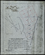
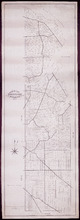
Plan of Dockriver: Showing Subdivisions to be leased for Oyster Culture.
Description: Plan of Dock River showing subdivisions to be leased for Oyster Culture. (No.14). The map shows residents, measurements, bays and Fox Island.
Province: Prince Edward Island
Type: cadastral maps
Date Created: 1913-11-17

Prince Edward Island National Park: Rustico Island and Brackley Beach Sections
Description: Prince Edward Island National Park. Rustico Island and Brackley Beach sections. Lots 24, 33 and 34. Department of Mines and Resources, Mines and Geology Branch, Bureau of Geology and Topography.
Province: Prince Edward Island
Type: cadastral maps, geological maps
Date Created: 1937
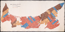
Map of Prince Edward Island showing Rural Catholic Religious Affiliation
Description: Map of Prince Edward Island showing Rural Catholic Religious Affiliation. Printed with color code shaded in with crayon. (Acc#2784/318) The map also shows bodies of water such as bays, and lots.
Province: Prince Edward Island
Type: cadastral maps, thematic maps
Plan of Webber Creek: being supplementary to "Plan of Richmond Bay from Curtain Island to…
Description: Plan of Webber Creek being supplementary to "Plan of Richmond Bay from Curtain Island to Lockes Shore" showing additional plots Nos. 478B, 478C, 478D, and 478E for Oyster Culture. The map… more
Province: Prince Edward Island
Type: plans
Date Created: 1913-10-08
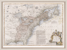
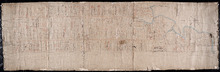
A Map of the British and French Settlements in North America
Description: Framed map; presenting French territories as far south as the mouth of the Mississippi. The map shows bodies of water such as, the Hudson's Bay, the Great Lakes, Northren mountains, fishing… more
Type: chorographic maps
Date Created: 1760 (year approximate)

Map of Prince Edward Island in the Gulf of St. Lawrence: for McGregor's British America
Publisher: Ballantyne and Company
Province: Prince Edward Island
Type: cadastral maps, topographic maps
Date Created: 1832

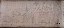
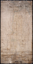
Plan of Township No. 55: Compiled from the plans on file in the Land and Registry Offices, from the…
Description: Plan of Lot 55 compiled from the plans on file in the Land and Registry Offices, from the descriptions in the registered Grants and from Meacham's Atlas. Shows names of residents, acreage, and… more
Province: Prince Edward Island
Type: cadastral maps
Date Created: 1919
This is the Plan of Township No. 24 in Prince Edward Island
Description: Plan of Lot 24 showing the division of the Winsloe Estate. Shows names of residents and acreage, bodies of water such as gulfs, bays, creeks, rivers, sand hills, Rustico or Peter's Island and… more
Province: Prince Edward Island
Type: cadastral maps
Date Created: 1863-03-13
Plan of Township No. 24 in Prince Edward Island
Description: Plan of Lot 24. Smith Estate. Mainly outline but shows a few residents and acreage, bodies of water such as rivers, gulfs, bays and creeks, roads, sand hills, and Rustico or Peter's Island. more
Province: Prince Edward Island
Type: cadastral maps
Plan of Lot Twenty One : Queens Co P.E.I.
Description: Plan of Lot 21 drawn from old maps, plans, and records. Shows names of residents, acreage, and land conveyance references, bodies of water such as bays, ponds, gulfs, and rivers, roads, and a… more
Province: Prince Edward Island
Type: cadastral maps
Date Created: 1952
Plan of Township No. 16 in Prince Edward Island: The Property Of Miss Sullivan
Description: Plan of Lot 16 (No.44). The property of Miss Sullivan. Shows names of residents, bodies of water, roads, and a compass. Color code shows freehold lands purchased from the Proprietor and other… more
Province: Prince Edward Island
Type: cadastral maps
Plan of Township No. 19: Situate in Prince County The Property of A.T.Todd ESQ. Toronto, Prince…
Description: Plan of Lot 19, the property of A.T. Todd, Toronto. Plan referred to in the Indenture dated 11 November, 1871 between A.T. Todd and E.J. Hodgson. Plan also referred to in a conveyance from E.J.… more
Province: Prince Edward Island
Type: cadastral maps
Plan of Lot or Township No. 5 in Prince Edward Island: The Shore and the Division line, coloured…
Description: Plan of Lot 5. The Shore and the Division line, coloured Yellow are according to actual Survey by A. Anderson. Shows names of residents, acreage, and land conveyance references, bodies of water such… more
Province: Prince Edward Island
Type: cadastral maps
Date Created: 1840
Plan of Lot 61 - Untitled
Description: Plan of Lot 61 (No.163). Sullivan Estate. Shows names of residents, acreage, and some land conveyance references bays and a nautical compass pointing North.
Province: Prince Edward Island
Type: cadastral maps
Plan of the western half of Lot 40 and Lot 39 east of Morell River
Description: Plan of the western half of Lot 40 and the part of Lot 39 east of Morell River. Shows names of residents and acreage, bodies of water such as bays, and rivers, and roads.
Province: Prince Edward Island
Type: cadastral maps

Plan of Alberton: Surveyed by John Ball, Land Surveyor
Description: Plan of part of Alberton, Lot 4. Shows names of residents and land conveyance references, bodies of water such as bays, and creeks, and roads.
Province: Prince Edward Island
Type: cadastral maps
Date Created: 1871-08
Plan of Township No 63, St. Andrews Parish Kings County: Prince Edward Island
Description: Plan of Lot 63. Eastern part shows names of residents, lots, acreage, bodies of water such as rivers, and bays, and roads.
Province: Prince Edward Island
Type: cadastral maps
Date Created: 1842
Plan of part of Township Number 35 situate on the North side of the Hillsborough River.: Those…
Description: Plan of Lot 35 (No.1). North side of the Hillsborough River. Property of Rev. John MacDonald. From a tracing by W.C. Harris. The map shows lots, residents, roads, and bodies of water.
Province: Prince Edward Island
Type: cadastral maps
Date Created: 1878-03-21
Plan of Part of Township No. 35 on the North Side of the Hillsborough River
Description: Plan of part of Lot 35 on the north side of the Hillsborough River. The map shows lots, residents, roads, Bedford Bay and foliage.
Province: Prince Edward Island
Type: cadastral maps