Displaying 1 - 54 of 773
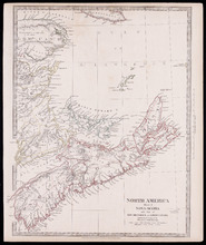
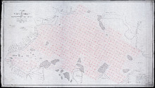
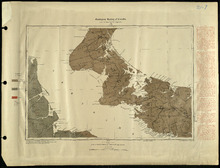
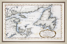
North America Sheet 1 : Nova Scotia with part of New Brunswick and Lower Canada
Description: North America, sheet 1, Nova Scotia with part of New Brunswick and Lower Canada. Published by Society for the Diffusion of Useful Knowledge. The map shows provinces, bodies of water, cities and towns… more
Province: Prince Edward Island, New Brunswick, Nova Scotia
Type: cadastral maps
Date Created: 1832-12-15

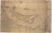
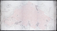
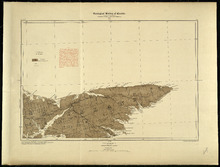
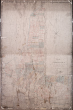
Prince Edward Island Nova Scotia and New Brunswick: Prince, Queens and Kings Counties, P.E.I.…
Description: Prince, Queens and Kings Counties, Prince Edward Island, portions of New Brunswick, Nova Scotia, and Magdalen Islands. It marks counties, parishes, cities, towns, and villages, beaches, marshes, Lots… more
Publisher: Hydrographic and Map Service, Labelle Building
Province: Prince Edward Island, Nova Scotia, New Brunswick, Quebec
Type: cadastral maps
Date Created: 1940
North America Dominion of Canada Gulf St. Lawrence Prince Edward Island: and Adjacent Coasts from…
Description: Prince Edward Island and adjacent coasts from Sea Wolf Island to Escuminac Point. Date of plan: April, 1888, corrected to 31 May, 1901.
Publisher: U.S. Navy Hydrographic Office
Province: Prince Edward Island
Type: nautical charts
Date Created: 1901
British possessions in North America from the Report of the Emigration Committee of 1827
Description: British possessions in North America, for the report of the Emigration Committee of 1827, corrected to 1834. Published by Longman & Co., London.
Publisher: Ashby, H., Longman & Co.
Province: New Brunswick, Nova Scotia, Prince Edward Island, Quebec, Maine, Vermont
Type: cadastral maps, topographic maps
Date Created: 1834

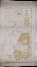
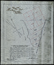
Plan of Lot or Township No 4, in P.E. Island: The shores and the division Lines coloured according…
Description: Plan of Lot 4. The shores and the division lines colored to yellow are according to actual survey. Shows names of some residents, acreage, roads, and bodies of water such as rivers.
Province: Prince Edward Island
Type: cadastral maps

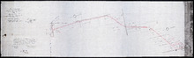
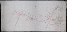
Plan of a Line of Road from Montague River Bridge to Wood Islands: Run in November 1833
Description: Plan of a line of road from Montague River Bridge to Wood Islands. Passes through Lots 59, 60, 61, and 62. (No.59). Shown are residents, lots, and rivers.
Province: Prince Edward Island
Type: cadastral maps
Date Created: 1833-11
Unfinished plan of Alberton and Cascumpec Point, Lots 4 and 5
Description: Unfinished plan of Alberton and Cascumpec Point, Lots 4 and 5. Mainly outline. Shows churches, station ground, school, and the names of a few residents.
Province: Prince Edward Island
Type: cadastral maps

Plan of Lot No 1 Shewing the Extent of the Fishery Reserve to the Crown and situation of settlers…
Description: Plan of Lot 1 (No.6) showing the extent of the Fishery Reserve to the Crown and situation of settlers thereon. Also the site of the respective fishery establishments of the same, as delineated from… more
Province: Prince Edward Island
Type: cadastral maps
Date Created: 1853-10
P.E.I. Railway Murray Harbour Branch : Plan Branch Line From Village Green to Vernon River Bridge
Description: Prince Edward Island Railway. Murray Harbour Branch. Plan of the branch line from Village Green to Vernon River Bridge (No.588). Plan produced by Wm. B. MacKenzie, Chief Engineer. The map shows lots… more
Province: Prince Edward Island
Type: cadastral maps
Date Created: 1906-05-28
Plan No 1 Office of the Registar of Deeds: Charlottetown P.E.Island
Description: Plan of land appropriated for the construction of the Murray Harbour Branch Railway through Queen's County (No.1). Plan produced by Wm. B. MacKenzie, Chief Engineer. The map shows residents,… more
Province: Prince Edward Island
Type: cadastral maps
Date Created: 1900-06-07
Plan of Cape Traverse Branch: Prince Edward Island Railway
Description: Canadian Government Railways, Prince Edward Island. Cape Traverse subdivision. Plans of the Railway right of way from Emerald Junction to Port Borden. Copied from the plans in the Engineer's… more
Province: Prince Edward Island
Type: cadastral maps
Plan of Railway appropriations in Lots 26, 27 and 28
Description: Plan of Railway appropriations in Lots 26, 27 and 28. The map shows lots, roads, residents, and acreage.
Province: Prince Edward Island
Type: cadastral maps, transportation maps
P.E.I. Railway: Elmira Branch Plan of Right-of-Way
Description: Prince Edward Island Railway. Elmira Branch. Plan of Right-of-Way (No.429, Kings Co.). Plan created by Wm. B. MacKenzie, Chief Engineer. The map shows lots, roads, residents, and acreage.
Province: Prince Edward Island
Type: cadastral maps
Date Created: 1909-06-02

Plan of Part of the Railway Line on Lots No 17.
Description: Plan of part of the Railway Line on Lot 17. Appropriations from the French Purchase to the Linkletter Road. The map shows roads, residents and acreage.
Province: Prince Edward Island
Type: cadastral maps, transportation maps
Date Created: 1872-04-29
Railway appropriations from Hunter River to Clyde Station: Lots 22 and 23
Description: Railway appropriations from Hunter River to Clyde Station. Lots 22 and 23. The map shows residents and acreage, roads, stations, ponds, and foliage.
Province: Prince Edward Island
Type: cadastral maps
Date Created: 1872
Plan-showing the Right of Way : Cape Traverse Branch P.E.I
Description: Plan showing the right of way of the Cape Traverse Branch of the Prince Edward Island Railway. The map shows roads, residents and acreage.
Province: Prince Edward Island
Type: cadastral maps

Plan Alterations of Railway on Lot 17 and Station Grounds at Summerside.
Description: Plan of Alterations of the Railway on Lot 17 and the Station Grounds at Summerside. The map shows lots, residents, streets, wharfs, and buildings.
Province: Prince Edward Island
Type: cadastral maps
Date Created: 1872-10-10
Plan of St. Martins, Township No. 35; Plan of 320 1/2 Acres of Land "Arisaig", Township…
Description: Plan of St. Martins, Lot 35 (south of the Hillsborough River). Also a plan of Arisaig, 320 and a half acres of land on Lot 35 and a plan of that part of Lot 36 north of the Hillsborough River.
Province: Prince Edward Island
Type: cadastral maps
Date Created: 1873
Map of Southport and Rosebank, Prince Edward Island: Drawn by C.D. Lambown Sept. 26, 1953
Description: Map of Southport and Rosebank, Lot.48. Shows names of residents, acreage, cities and towns, and Hillsborough River.
Province: Prince Edward Island
Type: cadastral maps
Date Created: 1953-09-26
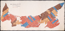
Map of Prince Edward Island showing Rural Catholic Religious Affiliation
Description: Map of Prince Edward Island showing Rural Catholic Religious Affiliation. Printed with color code shaded in with crayon. (Acc#2784/318) The map also shows bodies of water such as bays, and lots.
Province: Prince Edward Island
Type: cadastral maps, thematic maps
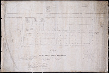
Plan of Richmond Bay from Grand River to Malpeque Harbour: showing location of Oyster Beds and…
Description: Plan of Richmond Bay from Grand River to Malpeque Harbour showing location of Oyster Beds and subdivisions for leasing purposes. (No.2) The map shows resdients, lots, measurements, islands, rivers,… more
Province: Prince Edward Island
Type: cadastral maps
Date Created: 1912-10-14
Plan of Richmond Bay from Grand River to Malpeque Harbour: Showing location of Oyster Beds and…
Description: Plan of Richmond Bay from Grand River to Malpeque Harbour showing location of Oyster Beds and subdivisions for leasing purposes. (No.2) The map shows residents, lots, measurements, islands, ponds and… more
Province: Prince Edward Island
Type: cadastral maps
Date Created: 1912-10-14

Topographical map of Prince Edward Island
Description: Topographical map of Prince Edward Island. Map has been cut into sections and pieced together. Therefore scale, date, etc. is missing. The maps shows mulitple bodies of water, counties, roads, towns… more
Province: Prince Edward Island
Type: cadastral maps

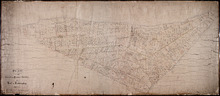
Plan of Township No. 67, and its environs.: Compiled from Surveys by Geo. Wright; H.J. Cundall;…
Description: Plan of Lot 67 and its environs. Compiled from surveys by Geo. Wright, H.J. Cundall, Joseph Ball, and Owen Curtis. Drawn by Thomas MacKinlay. Shows names of some residents, roads, railroads, bodies… more
Province: Prince Edward Island
Type: cadastral maps
Date Created: 1877-08-01
Stanhope Shore Rd.
Description: The map shows the Stanhope Shore Road with the names of residents, their road frontage measurements and dollar amounts for each.
Province: Prince Edward Island
Type: cadastral maps
Date Created: 1954

Provincal Electorial Map of Prince Edward Island
Description: The map shows Prince Edward Island divided into electoral districts, which are numbered by county.
Province: Prince Edward Island
Type: thematic maps

Map of Prince Edward Island
Description: Map of Prince Edward Island showing school districts(?). The map shows bodies of water and town and cities.
Province: Prince Edward Island
Type: cadastral maps, thematic maps
Date Created: 1971-02-05
Prince Edward Island
Description: Prince Edward Island. Geological Survey of Canada. The map shows the North Point of the island, roads, railways, post offices, towns, and cities.
Province: Prince Edward Island
Type: geological maps
Date Created: 1884
Prince Edward Island
Description: Prince Edward Island. Geological Survey of Canada. The map shows Prince county, roads, bodies of water, cities and towns.
Province: Prince Edward Island
Type: geological maps
Date Created: 1884
Plan of Webber Creek: being supplementary to "Plan of Richmond Bay from Curtain Island to…
Description: Plan of Webber Creek being supplementary to "Plan of Richmond Bay from Curtain Island to Lockes Shore" showing additional plots Nos. 478B, 478C, 478D, and 478E for Oyster Culture. The map… more
Province: Prince Edward Island
Type: plans
Date Created: 1913-10-08
Prince Edward Island
Description: Prince Edward Island. Geological Survey of Canada. The map shows Kings county roads, cities and towns.
Province: Prince Edward Island
Type: geological maps
Date Created: 1884
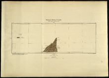
Plan of the Cunard and Palmer Estates in Lot or Township No.1.
Description: Plan of Lot 1 (No.1). Cunard and Palmer Estates. Drawn by Owen Curtis. Shows names of residents, acreage, and a few land conveyance references, and roads.
Province: Prince Edward Island
Type: cadastral maps
Plan of Township No 15: Taken from the survey of William Cutis (1826) wit alterations and…
Description: Plan of Lot 15 (No.42) taken from the survey of William Curtis (1826) with alterations and corrections from surveys made in 1849 and 1851 by Geo. Wright. Color code shows Crown Lands and lands… more
Province: Prince Edward Island
Type: cadastral maps
Date Created: 1851

Plan of Township No. 48: compiled during the year 1915 from plans on file in the Land Office and…
Description: Plan of Lot 48 compiled during the year 1915 from plans on file in the Land Office and Registry Office and from the chart of Charlottetown Harbour supplemented by the descriptions in the leases and… more
Province: Prince Edward Island
Type: cadastral maps
Date Created: 1915

Plan of Township No. 63: compiled from the proprietors' plans, descriptions in leases and…
Description: Plan of Lot 63 compiled from the proprietors' plans, descriptions in leases and registered deeds, and from Meacham's Atlas, with additions and corrections from surveys made at various times… more
Province: Prince Edward Island
Type: cadastral maps
Date Created: 1921-02
Carte Nouvelle contenant la Partie d'Amerique La Plus Septentrionale, ou sont exactement…
Description: The map shows the Gulf of St. Lawrence, the northeast Atlantic and the provinces of New Brunswick, Newfoundland, Nova Scotia and Prince Edward Island, as well as part of Quebec. Sable Island,… more
Province: New Brunswick, Newfoundland, Nova Scotia, Prince Edward Island, Quebec
Type: topographic maps
Date Created: 1666
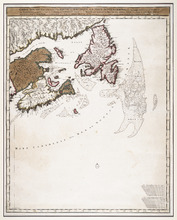
A NewFoundland, od. Terra Nova S. Laurentii Bay, die Fisch-Bank, Acadia, nebst einem Theil New…
Description: The map shows the Gulf of St. Lawrence, part of the northeast Atlantic and the provinces of New Brunswick, Newfoundland, Nova Scotia and Prince Edward Island, as well as part of Quebec. Sable Island… more
Province: New Brunswick, Newfoundland, Nova Scotia, Prince Edward Island, Quebec
Type: topographic maps
Date Created: 1720
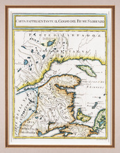
Carta Rappresentante il Golfo del Fiume S. Lorenzo
Description: The map shows the St. Lawrence River/Gulf of St. Lawrence region as far west as the Saguenay River and as far east as Cape Breton. It shows New Brunswick, Prince Edward Island, and parts of Nova… more
Province: New Brunswick, Nova Scotia, Prince Edward Island, Quebec
Type: topographic maps
Date Created: 1765 (year approximate)
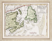
Carte du Golphe de St. Laurent et Pays Voisins Pour Servir a l'Histoire Generale des Voyages.
Description: The map shows the Gulf of St. Lawrence, New Brunswick, Newfoundland, Prince Edward Island, and parts of Nova Scotia and Quebec. It shows Anticosti Island and the Magdelan Islands. The map uses labels… more, Provenance: Purchased by Mr. Macnutt in London at the Map House in 1982. [Information from the back of the item], Exhibition & Catalogue: 1. The James W. Macnutt Collection of Maps of the Gulf of St. Lawrence with Particular Emphasis on Prince Edward Island, Confederation Centre Art Gallery and Museum, June… more
Province: New Brunswick, Newfoundland, Nova Scotia, Prince Edward Island, Quebec
Type: topographic maps
The British Colonies in North America
Description: The map shows New Brunswick, Nova Scotia, Prince Edward Island and parts of Ontario, Quebec and the United States. Newfoundland is shown at the same scale in an inset in the upper left corner. Rivers… more
Publisher: James S. Virtue
Province: New Brunswick, Newfoundland, Nova Scotia, Prince Edward Island, Ontario, Quebec
Type: topographic maps
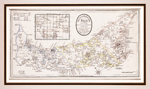
Prince Edward Island, divided into Counties & Parishes, with the Lots, as Granted by Government…
Description: Framed map of the province of Prince Edward Island. As the title indicates, the map shows Prince Edward Island divided into counties (shown in blue, yellow and pink), parishes and the Holland lots.… more
Publisher: Ashby, H.
Province: Prince Edward Island
Type: topographic maps
Date Created: 1798
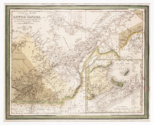
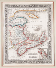
Canada East, Formerly Lower Canada. [with] Nova Scotia, New Brunswick &c.: Published by S.…
Description: The map shows part of Quebec (Canada East) and adjoining parts of New Brunswick and the United States. An inset map shows New Brunswick, Nova Scotia and Prince Edward Island. Colour is used to… more
Publisher: S. Augustus Mitchell
Province: New Brunswick, Nova Scotia, Prince Edward Island, Quebec
Type: topographic maps
Date Created: 1846
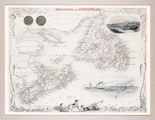
Nova Scotia and Newfoundland
Description: The map shows Newfoundland, Nova Scotia and Prince Edward Island and parts of New Brunswick and Quebec. Newfoundland, Nova Scotia, P.E.I., Anticosti Island and the Magdalen Islands are mapped in… more
Publisher: J. & F. Tallis
Province: Newfoundland, Nova Scotia, Prince Edward Island
Type: topographic maps
Date Created: 1851
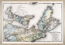
County Map of Nova Scotia New Brunswick Cape Breton Id. and Pr. Edward's Id.
Description: The map shows New Brunswick, Nova Scotia and Prince Edward Island and parts of Quebec and Maine. An inset shows the "City and Harbor of Halifax." Bright colours are used to outline… more
Publisher: S. A. Mitchell Jr.
Province: New Brunswick, Nova Scotia, Prince Edward Island
Type: topographic maps
Date Created: 1860
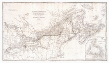
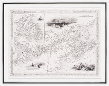
New Atlas of the Dominion of Canada — Counties of Cumberland, Colchester, Pictou, Antigonish,…
Description: The map shows Prince Edward Island and part of Nova Scotia, including all of Cape Breton. The provinces' counties are coloured and labelled in uppercase lettering. A legend explains the symbols… more
Publisher: Meacham Publishing Co.
Province: Nova Scotia, Prince Edward Island
Type: topographic maps
Date Created: 1875 (year approximate)

Geological Map of Canada and Newfoundland: Derive from the Results of The Canadian Geological…
Description: Framed map of Canada and Newfoundland. The map is has colours for different land marks, and a table that explains it all. Shown are bodies of water such as rivers, islands, roads, towns, and cities.
Province: Newfoundland, New Brunswick, Prince Edward Island, Nova Scotia, Quebec
Type: geological maps
Date Created: 1866 (year uncertain)
Plan of Cascumpec Point As sold by Public Auction in June 1871
Description: Plan of Cascumpec Point, as sold by public auction, June, 1871. The map shows lots, residents, bodies of water such as bays, cities and towns, and roads.
Province: Prince Edward Island
Type: cadastral maps
Date Created: 1871-08

Plan of that portion of the town of Summerside laid off on the front of the farm by Mr. Jesse Green.
Description: Plan of that portion of the town of Summerside laid off on the front of the farm by Mr. Jesse Green. The map shows lots, residents, towns, cities, roads, and bodies of water.
Province: Prince Edward Island
Type: cadastral maps
Date Created: 1868-11-25
A Plan of the Property of Capt. Simon and Alexander Cheverie: in Souris East
Description: A plan of the property of Capt. Simon and Alexander Cheverie in Souris East. The map shows lots, acreage, roads/streets, and buildings.
Province: Prince Edward Island
Type: cadastral maps
Date Created: 1879-06-18

Common Lot No 21 as divided into Building Lots
Description: Plan of Common Lot No.21. Charlottetown as divided into building lots. (No.380) The map shows lots, acreage and roads/streets.
Province: Prince Edward Island
Type: cadastral maps
Date Created: 1872-08
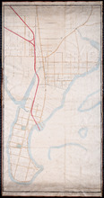
P.E.Island Railway: Charlottetown
Description: Prince Edward Island Railway. Charlottetown. Appropriations into Charlottetown Station. The map shows roads, streets, lots, and buildings.
Province: Prince Edward Island
Type: plans
Date Created: 1871

Plan of Lot 5
Description: Plan of Lot 5. Shows names of residents and acreage, rivers, creeks, roads, bays and Islands.
Province: Prince Edward Island
Type: cadastral maps

Plan of George Town: The Town Lots are 84 by 120 Feet. The North and South Streets are 100 Feet.…
Description: Plan of Georgetown showing lots and streets, bays, ranges, squares, and a school house. Also shows location of school house. Copy from the Office Plan No.6.
Province: Prince Edward Island
Date Created: 1853-06-07

A Plan of Township No 4 Part of the Cunard Estate Prince County P.E.Island
Description: A plan of Lot 4, part of the Cunard Estate. Copied from plans in the Public Lands Department. The map shows lots, residents, bodies of water such as rivers, railways, and roads.
Province: Prince Edward Island
Type: cadastral maps
Date Created: 1885-06