Displaying 406 - 432 of 559
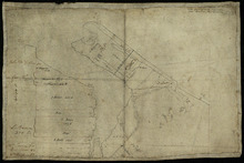
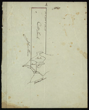
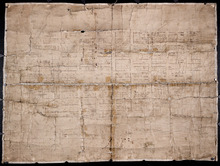
Part of Lot 34
Description: Plan of part of Lot 34 (No.5). Shows properties of John Millar, L. Brown, Neil Shaw, Murdock McCloud, and John Crabtree. The map shows the northwestern portion of Lot 34 divided into parcels of land… more
Province: Prince Edward Island
Type: cadastral maps
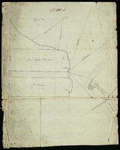
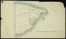
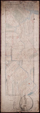
Part of Lot 34
Description: Plan of part of Lot 34 (No.3). Area around Covehead Bay. The map shows the northwestern portion of Lot 34, divided into parcels of land with the names of residents and/or proprietors and their… more
Province: Prince Edward Island
Type: cadastral maps
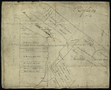
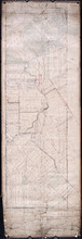
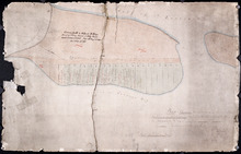
Part of Lot 34
Description: Plan of part of Lot 34 (No.6). Area around Covehead Bay. The map shows the northwestern portion of Lot 34 divided into parcels of land with the names of residents and/or proprietors and their acreage… more
Province: Prince Edward Island
Type: cadastral maps
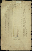
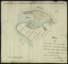
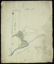
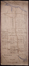
Plan of Mrs. Vickersons Land
Description: Plan of part of Lot 34 (No. 4). 74 acres of land. The map shows Barbarey Vickerson's 74-acre parcel of land on the north side of the Hillsborough River in Lot 34. The plan shows roads, including… more
Province: Prince Edward Island
Type: cadastral maps
Date Created: 1809-10-12
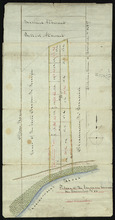
Plan of A tract of Land the property the Messrs. Macmillans & Peter Higgins on Township No. 34…
Description: Plan of part of Lot 34 (No. 182). The map shows a parcel of land 111 acres in size belonging to Angus MacMillan, Peter Higgins and Alexander MacMillan near the entrance to Covehead Harbour and what… more
Province: Prince Edward Island
Type: cadastral maps
Date Created: 1854
Plan of the Indian Reserve on Township No. 36
Description: Plan of part of Lot 36. The map shows a parcel of land, approximately 150 acres in size, identified as an Indian Reserve on the north side of the Hillsborough in Lot 36. The parcel is outlined in… more
Province: Prince Edward Island
Type: cadastral maps
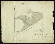
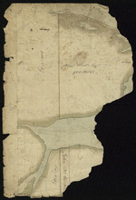
A Plan of the French Marsh: the property of Wm. Townshend. Esqr.
Description: Plan of part of Lot 37 (No.9). The French Marsh. The map shows a marsh area belonging to William Townshend on the north side of the Hillsborough River in Lot 37. Marsh area is shaded and coloured… more
Province: Prince Edward Island
Type: cadastral maps, topographic maps
Lot 37 - No. 7
Description: Plan of part of Lot 37 (No. 7). Area south of the Hillsborough River. The maps shows a small area on the south side of the Hillsborough River in Lot 37 adjacent to the boundary with Lot 38. It shows… more
Province: Prince Edward Island
Type: cadastral maps
Plan of 150 Acres of Land Part of Lot No. 37.
Description: Plan of part of Lot 37 (No. 8). 150 acres of land, the property of John Stowe. The map shows a parcel of land, approximately 150 acres in size, outlined in yellow, on the north side of the… more
Province: Prince Edward Island
Type: cadastral maps
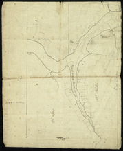
Plan of the French Marsh: Lot 37 - No. 10
Description: Plan of part of Lot 37 (Nos. 10 and 58). This item consists of three maps on three separate sheets, all showing the same area. The maps show the French Marsh on the north side of the Hillsborough… more
Province: Prince Edward Island
Type: cadastral maps, topographic maps
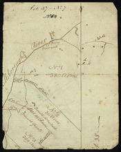
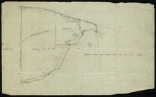
Lot 37 - No. 12
Description: Plan of part of Lot 37 (No. 12). The Pisquid or Hill River area. Outline. The map shows the area where the Pisquid (or Hill) River joins the Hillsborough River in Lot 37. It gives the names of some… more
Province: Prince Edward Island
Type: cadastral maps, topographic maps
Part of Lot 37
Description: Plan of part of Lot 37 (No. 13). Property of Mr. Leech.[?] The map shows a parcel of land on the north side of the Hillsborough River in Lot 37. It gives the names of two residents. The map shows the… more
Province: Prince Edward Island
Type: cadastral maps
Part of Lot 38
Description: Plan of part of Lot 38 (No. 8). Coffin property. 220 acres of land bordering on Savage Harbour. The map shows the northwestern-most part of Lot 38 that is separated from the rest of the lot by Savage… more
Province: Prince Edward Island
Type: cadastral maps
Part of Lot No. 38
Description: Plan of part of Lot 38 (No. 8), Coffin property. 220 acres of land bordering on Savage Harbour. The map shows the northwestern-most part of Lot 38 that is separated from the rest of the lot by Savage… more
Province: Prince Edward Island
Type: cadastral maps

Part of Lot 38
Description: Plan of part of Lot 38 (No. 9). 1100 acres, the property of Alex Watts. The map shows part of Lot 38, including a parcel of land belonging to Alexander Watts. It gives the names of several other… more
Province: Prince Edward Island
Type: cadastral maps
Part of Lot 38: No. 13
Description: Plan of part of Lot 38 (No.13). 900 acres, the property of Alex Watts. Part of plan is missing. The map shows a 900-acre parcel of land belonging to Alexander Watts Esqr. in the northwestern corner… more
Province: Prince Edward Island
Type: cadastral maps
Part of Lot 38: No. 14
Description: Plan of part of Lot 38 (No. 14). Capt. Bentinck's land. The map shows a parcel of land belonging to Captain Bentinck, north of the Hillsborough River in Lot 38. It gives names of residents and… more
Province: Prince Edward Island
Type: cadastral maps
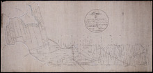
The Original Plan of Charlottetown Lots, No.1.
Description: Early plan of Charlottetown entitled "The Original Plan of Charlottetown Lots, No.1." Shows town lots, houses, windmill, battery, gallows, and the names of residents. Also includes code… more
Province: Prince Edward Island
Type: cadastral maps
Plan of Part of Lot No. 23
Description: Plan of the northern part of Lot 23 (No.62). Hodgson Estate. Shows names of residents and acreage, Gulf of St. Lawrnce, creeks, rivers, and roads. Color code indicates free and leased land.
Province: Prince Edward Island
Type: cadastral maps
Plan of the Estate of D.S. Rennie Esqr. on Lot No. 23 in Queens County Prince Edward Island: As…
Description: The map shows a southern portion of Lot 23 divided into numbered parcels of land with the names of residents and their acreage amounts. Some parcels are coloured green. The map also shows the land… more
Province: Prince Edward Island
Type: cadastral maps
Date Created: 1863
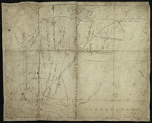
Plan of Township No. 23
Description: Plan of Lot 23. Shows the estates of Susan Rennie, David S. Rennie and Daniel Hodgson. Gives names of residents, acreage, and a few land conveyance references, rivers, gulfs, roads, towns, and a… more
Province: Prince Edward Island
Type: cadastral maps
Plan of Part of Lot or Township No.23 in grenville Parish in Queens County, Prince Edward Island
Description: Plan of part of Lot 23 (No.61). The estate of David Rennie. Shows names of residents, acreage, and some land conveyance references, rivers, and roads.
Province: Prince Edward Island
Type: cadastral maps
Date Created: 1864-05
Plan Shewing the situation of the respective Fishing Establishments, Fronting Harris or Rustico Bay…
Description: Plan of part of Lot 24. Shows situation of the fishing establishments fronting Harris or Rustico Bay. From actual survey. The map shows the Harbours Mouth and Robinsons Island.
Province: Prince Edward Island
Type: cadastral maps
Date Created: 1869-09-02
Tracing of Plan of A part of the South Moiety of Lot or Township No. 26 in Prince County in the…
Description: Plan of part of the south moiety of Lot 26, including the property of A. E. C. Holland. Plan drawn by John Clay. The map shows part of the southern half of Lot 26 divided into parcels of land with… more
Province: Prince Edward Island
Type: cadastral maps
Date Created: 1876-05-12
Plan of Lot 27 Prince County: The Property of James P.
Description: Plan of the northern part of Lot 27 (No.72). Pope Estate. Shows names of residents and acreage, the Northumberland Strait, mill pond, and roads. Plan referred to in the Deed from Pope to the… more
Province: Prince Edward Island
Type: cadastral maps
Plan of Part of the Estate of R.B. Stewart Esq. Situate on Lot or Township No. 27 shewing the…
Description: Plan of part of Lot 27. Estate of R.B. Stewart. Shows names of residents, acreage, and a few land conveyance references, roads, and the sea shore.
Province: Prince Edward Island
Type: cadastral maps
Date Created: 1848-03-24
A Plan of Part of Lot No. XXVII Situat in P.E.I. the Property of J. Cambridge Esq. from an Actual…
Description: Plan of part of Lot 27 (No.74). The property of J. Cambridge. Shows names of residents and acreage, Carlton Cove and a compass. Plan is one of those referred to in the Deed from Sir Edward, William… more
Province: Prince Edward Island
Type: cadastral maps
Date Created: 1828-08