Displaying 28 - 54 of 126
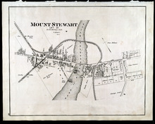
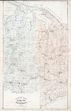
Mount Stewart: Lot 37
Description: The map shows lot 37 in Mount Stewart. Shown are roads, railroads and depot, landowners, houses, churches, Hillsborough river, wharfs, halls, and shipyard. Compass.
Publisher: J. H. Meacham & company
Province: Prince Edward Island
Type: cadastral maps
Date Issued (Source): 1880
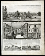
Property Sketches - Page 38
Description: Property sketches of the Residence of Hon. W. W. Sullivan, Charlottetown, P.E.I.; E.W. Taylor' Jewelry Store - interior and exterior, South Side Queen Square, Charlottetown, P.E.I.; The farms of… more
Publisher: J. H. Meacham & company
Province: Prince Edward Island
Type: image
Date Issued (Source): 1880

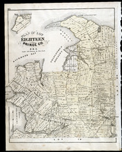
Plan of Lot Four : Prince Co., P.E.I.
Description: Map showing lots four
Publisher: J. H. Meacham & company
Province: Prince Edward Island
Type: cadastral maps
Date Issued (Source): 1880

Plan of Lot Eight: Prince Co., P.E.I.
Description: The map shows lot 8 in Prince county. Shown are roads, landowners and acreage, rivers, Northumberland strait, ponds, lighthouses, post offices, churches, mills, and businesses. Compass.
Publisher: J. H. Meacham & company
Province: Prince Edward Island
Type: cadastral maps
Date Issued (Source): 1880

Plan of Lot Thirteen: Prince Co., P.E.I.
Description: Map showing lot thirteen, bordering lots 12, 14 and 15, in Prince county. Shows gulfs, straits, bays, rivers, ponds, creeks, railroads, roads, landowners, acreage, post offices, and buildings.… more
Publisher: J. H. Meacham & company
Province: Prince Edward Island
Type: cadastral maps
Date Issued (Source): 1880

Plan of Lot Nine: Prince Co., P.E.I.
Description: The map shows lot 9 in Prince county. Shown are roads, landowners and acreage, Egmont bay, sand, Brae river, post offices, railroad and station, schools and churches. Compass.
Publisher: J. H. Meacham & company
Province: Prince Edward Island
Type: cadastral maps
Date Issued (Source): 1880

Plan of Lot Fourteen & Sixteen : Prince Co., P.E.I.
Description: Map shows lots fourteen & sixteen in Prince county. Shown are roads, creeks, coves, rivers, post offices, railroads and stations, ferries, points, bays, landowners, acreage, churches, and… more
Publisher: J. H. Meacham & company
Province: Prince Edward Island
Type: cadastral maps
Date Issued (Source): 1880

Plan of Lot Ten: Prince Co., P.E.I.
Description: The map shows lot 10 in Prince county. Shown are roads, rivers and creeks, railroad and station, post offices, a school, and landowners and acreage. Compass.
Publisher: J. H. Meacham & company
Province: Prince Edward Island
Type: cadastral maps
Date Issued (Source): 1880

Plan of Lot Seventeen: Prince Co., P.E.I.
Description: The map shows lot 17 along with two smaller maps of lot 17 and 23. The map includes landowners and acreage, railroads and stations, roads, districts, creeks, rivers, bays, marshes, brooks, coves,… more
Publisher: J. H. Meacham & company
Province: Prince Edward Island
Type: cadastral maps
Date Issued (Source): 1880
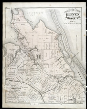
Plan of Lot Eleven: Prince Co., P.E.I.
Description: The map shows lot 11 in Prince county. Shown are roads, landowners and acreage, rivers, bays, coves, creeks, ponds, sand, railroad and station, post offices, and school houses. Compass.
Publisher: J. H. Meacham & company
Province: Prince Edward Island
Type: cadastral maps
Date Issued (Source): 1880

Plan of Lot Twenty One & Twenty: Queens Co., P.E.I.
Description: The map shows lots 21 and 20 (coloured in pink) in Queens county that border Prince county. The map names roads, landowners and acreage, creeks, gulfs, rivers, coves, fishing stations, post offices,… more
Publisher: J. H. Meacham & company
Province: Prince Edward Island
Type: cadastral maps
Date Issued (Source): 1880

Victoria, Lot 29; Map of Lennox Island
Description: The page displays map of Victoria in Lot 29. Shown are roads and streets, a harbour, wharfs, landowners, post offices, buildings and school houses. Compass. The page also displays a map of Lennox… more
Publisher: J. H. Meacham & company
Province: Prince Edward Island
Type: cadastral maps
Date Issued (Source): 1880
Plan of Lots 22 & 23 : Queens Co., P.E.I.
Description: The map shows lots 22 and 23 in Queens county. The map names roads, landowners and acreage, churches, halls, post offices, railroads, rivers, bays, and guls. Graphic compass.
Publisher: J. H. Meacham & company
Province: Prince Edward Island
Type: cadastral maps
Date Issued (Source): 1880
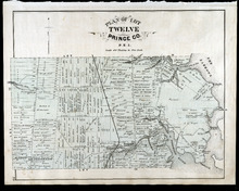
Plan of Lot Twelve: Prince Co., P.E.I.
Description: The map shows lot 12 in Prince county. Shown are the Narrows, roads, railroad and station, ponds, landowners and acreage, school houses, creeks, rivers, and coves.
Publisher: J. H. Meacham & company
Province: Prince Edward Island
Type: cadastral maps
Date Issued (Source): 1880
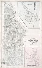
Plan of Lot Twenty Four: Queens Co., P.E.I.
Description: The map shows lot 24 in Queens county. Shown are rivers, gulfs, capes harbours, wharfs, lighthouses, fishing stages and holes, seaside hotels and bath houses, churches, crosses, post offices, roads,… more
Publisher: J. H. Meacham & company
Province: Prince Edward Island
Type: cadastral maps
Date Issued (Source): 1880
Plan of Lots Twenty Five & Twenty Six: Prince Co., P.E.I.
Description: The map shows lots 25 and 26 in Prince county. The map names roads, landowners and acreage, railroads, post offices, churches, harbours, lighthouses, hotels, coves. and rivers. Graphic compass.
Publisher: J. H. Meacham & company
Province: Prince Edward Island
Type: cadastral maps
Date Issued (Source): 1880
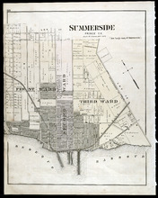
Summerside: Prince Co., P.E.I.
Description: The map shows the city of Summerside. Shown are the wards, a corportion line, landowners and acreage, roads, cemetery, buildings, railroad wharfs, and a harbour.
Publisher: J. H. Meacham & company
Province: Prince Edward Island
Type: cadastral maps
Date Issued (Source): 1880

Plan of Lot Twenty Seven: Prince Co., P.E.I.
Description: The map shows lot 27 in Prince county. The map shows roads, railroads, crosses, ponds, rivers, bays, straits, coves, mills, post offices, and churhces. Graphic compass.
Publisher: J. H. Meacham & company
Province: Prince Edward Island
Type: cadastral maps
Date Issued (Source): 1880
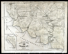
Plan of Lot 28: Prince Co., P.E.I.
Description: The map shows lot 28 in Prince county. Shown are straits, coves, rivers, Anglo-American cable, Winter Crossing Ice Boats, post offices, churches, landowners and acreage, and factories. Compass.
Publisher: J. H. Meacham & company
Province: Prince Edward Island
Type: cadastral maps
Date Issued (Source): 1880
Plan of Lots Twenty Nine & Thirty: Queens Co., P.E.I.
Description: The map shows lots 29 (coloured in blue) and 30 (coloured in pink) in Queens county. The map shows straits, rivers, post offices, roads, landowners and acreage, and churches. Graphic compass.
Publisher: J. H. Meacham & company
Province: Prince Edward Island
Type: cadastral maps
Date Issued (Source): 1880
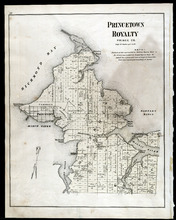
Princetown Royalty: Prince Co., P.E.I.
Description: The map shows Princetown Royalty, in Prince county. Shown are Bays, a basin, rivers, commons, sand, points, wharfs, churches, cemetery, post offices, roads, and landowners.
Publisher: J. H. Meacham & company
Province: Prince Edward Island
Type: cadastral maps
Date Issued (Source): 1880
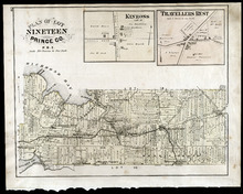
Plan of Lot Nineteen: Prince Co., P.E.I.
Description: The map shows lot 19 in Prince county. Shown are creeks, bays, roads, railroads and stations, landowners and acerage, post offices and buildings. Compass.
Publisher: J. H. Meacham & company
Province: Prince Edward Island
Type: cadastral maps
Date Issued (Source): 1880
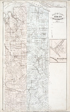
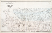
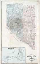
Plan of Lots 33 & 34: Queens Co., P.E.I.
Description: The map shows lots 33 (coloured in blue) & 34 (coloured in pink) in Queens county. The map shows roads, railroads and stations, landowners and acreage, farms, post offices, churches, hotels,… more
Publisher: J. H. Meacham & company
Province: Prince Edward Island
Type: cadastral maps
Date Issued (Source): 1880
Plan of Lot Eighteen: Prince Co., P.E.I.
Description: The map shows lot 18 in Prince county. Shown are bays, capes, points, coves, post offices, schools, creeks, mills, churches, landowners and acreage, and roads. Compass.
Publisher: J. H. Meacham & company
Province: Prince Edward Island
Type: cadastral maps
Date Issued (Source): 1880
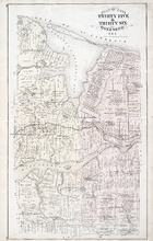
Plan of Lot Thirty Five & Thirty Six: Queens Co., P.E.I.
Description: The map shows lots 35 & 36 in Queens county. Shown are gulfs, bays, sand, coves, wharfs, rivers, ponds, creeks, fishing houses, roads, landowners and acreage, post offices, school houses,… more
Publisher: J. H. Meacham & company
Province: Prince Edward Island
Type: cadastral maps
Date Issued (Source): 1880
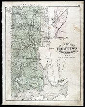
Plan of Lot Thirty Two: Queens Co., P.E.I.
Description: The map shows lot 32 in Queens county. Shown are roads, landowners and acreage, railroad and station, post offices, rivers, churches, and coves. Compass.
Publisher: J. H. Meacham & company
Province: Prince Edward Island
Type: cadastral maps
Date Issued (Source): 1880

Plan of Lot Thirty Seven : Plan of Lot Thirty Eight: Queens Co., P.E.I.. Kings Co., P.E.I.
Description: The map shows lot 37 (coloured in pink) in Queens county, and lot 38 (coloured in blue) in Kings county. Shown are roads, railroads, landowners and acreage, rivers, ponds, harbours, gulfs, creeks,… more
Publisher: J. H. Meacham & company
Province: Prince Edward Island
Type: cadastral maps
Date Issued (Source): 1880