Displaying 190 - 216 of 297
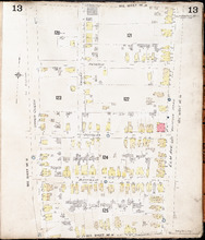
Charlottetown P.E.I.: July, 1903.
Description: This is Page 13 of 20 pages of fire insurance maps of Charlottetown. It was created in 1903 and revised to either 1910 or 1917. It shows the area bounded by Connolly Street in the north, Elm Avenue/… more
Publisher: Chas. E. Goad, Civil Engineer
Province: Prince Edward Island
Type: fire insurance maps
Date Created: 1903-07
Date Modified: 1910-08, 1917-07 (year and month uncertain)
Date Issued (Source): 1888
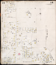
Charlottetown P.E.I.: July, 1903.
Description: This is Page 14 of 20 pages of fire insurance maps of Charlottetown. It was created in 1903 and revised to either 1910 or 1917. It shows the area from Allan (Allen) Street, in the north, to (… more
Publisher: Chas. E. Goad, Civil Engineer
Province: Prince Edward Island
Type: fire insurance maps
Date Created: 1903-07
Date Modified: 1910-08, 1917-07 (year and month uncertain)
Date Issued (Source): 1888
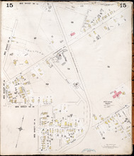
Charlottetown, P.E.I.: July, 1903.
Description: This is Page 15 of 20 pages of fire insurance maps of Charlottetown. It was created in 1903 and revised to either 1910 or 1917. The map shows part of the eastern portion of early twentieth-century… more
Publisher: Chas. E. Goad, Civil Engineer
Province: Prince Edward Island
Type: fire insurance maps
Date Created: 1903-07
Date Modified: 1910-08, 1917-07 (year and month uncertain)
Date Issued (Source): 1888
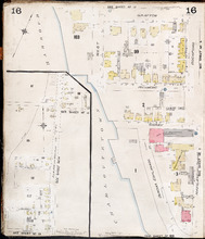
Charlottetown P.E.I.: July 1903
Description: This is Page 16 of 20 pages of fire insurance maps of Charlottetown. It was created in 1903 and revised to either 1910 or 1917. It contains two (2) maps, showing two (2) different areas of the city.… more
Publisher: Chas. E. Goad, Civil Engineer
Province: Prince Edward Island
Type: fire insurance maps
Date Created: 1903-07
Date Modified: 1910-08, 1917-07 (year and month uncertain)
Date Issued (Source): 1888
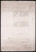
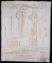
Plan of part of Town Lots Nos. 54 and 55, and Nos. 91 and 92 in the 2nd Hundred of Town Lots in…
Description: Plan of part of Town Lots Nos. 54 and 55, and Nos. 91 and 92 in the 2nd Hundred of Town Lots in Charlottetown agreeably to the possession of the Misses Stewart according to the original survey of the… more
Province: Prince Edward Island
Type: cadastral maps
Date Created: 1860-07-25

Plan of Lot 48 (No.2)
Description: Plan of Lot 48 (No.2). Shows property of Peter Stewart, Tho. Wright, Tho. DesBrisay, Chas. Stewart, and James Park. Also shows property leased to R. Stewart. Gives location of Battery and the acreage… more
Province: Prince Edward Island
Type: cadastral maps

Incomplete part of Lot 48 (No.130)
Description: Incomplete part of Lot 48 (No.130). Shows the following estates: DesBrisay, Crooke, Cummingham, Cunard, and Lawton. Also gives the names of some residents.
Province: Prince Edward Island
Type: cadastral maps
Plan of the southwestern part of Lot 48 (No.3)
Description: Plan of the southwestern part of Lot 48 (No.3). Gives names of some residents. Shows the location of York Battery and the Reserved Land at Crab Point.
Province: Prince Edward Island
Type: cadastral maps
Map of Lot Forty-Eight: J.H. Meachams and Co. Atlas
Description: Map of Lot 48. Draft for Meacham's Atlas. Also includes inset map of Southport or Stratford (scale: 6 chains/inch). Shows the Charlottetown Royalty, bodies of water such as rivers, and lakes,… more
Province: Prince Edward Island
Type: cadastral maps
Plan of Lots 49 and 50 showing Loyalist Shares drawn for in Council, 12 February, 1784.
Description: Plan of Lots 49 and 50 showing Loyalist Shares drawn for in Council, 12 February, 1784. Shown are lots and measurements.
Province: Prince Edward Island
Type: cadastral maps
Plan of a Part of Township No. 35 on the South Side of the Hillsborough River: Those portions…
Description: Plan of part of Lot 35 on the south side of the Hillsborough River showing the property of Rev. John Alister Somerlet MacDonald. Copied from a tracing by W.C. Harris in the Land Office (Plan No.3).… more
Province: Prince Edward Island
Type: cadastral maps
Date Created: 1878

Partial plan of Lot 48
Description: Partial plan of Lot 48. Mainly outline. Shows names of some residents in southern half of Lot. The map shows residents and lots, and roads.
Province: Prince Edward Island
Type: cadastral maps

Plan of Lot 49
Description: Plan of Lot 49 (No.6). Outline.
Province: Prince Edward Island
Type: cadastral maps

Plan showing the situation of the line of road from Melville Road to Appin Road also the connecting…
Description: Plan showing the situation of the line of road from Melville Road to Appin Road; also, the connecting road leading to Crapaud Wharf. Roads pass through Lots 29 and 30. (No.15, Queen's). Shown… more
Province: Prince Edward Island
Type: cadastral maps
Date Created: 1868-06-08

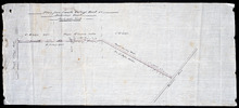
Plan of New Line Road from South Wiltshire Road Lot 31 to Emyvale Road Lot 65
Description: Plan of new line of road from South Wiltshire Road, Lot 31, to Emyvale Road, Lot 65. The map shows lots, roads, and residents.
Province: Prince Edward Island
Type: cadastral maps
Date Created: 1892-12-29
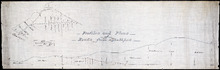
Profiles and plans of roads from Southport
Description: Profiles and plans of roads from Southport. (No.10) The map shows roads, lots, residents, and acreage.
Province: Prince Edward Island
Type: cadastral maps

Plan of proposed road from Winsloe Road to Brackley Point Road touching at Roy; Junc; Station
Description: Plan of proposed road from Winsloe Road to Brackley Point Road touching at Royalty Junction Station. Lot 33. (No.28) The map shows lots, roads, and residents.
Province: Prince Edward Island
Type: cadastral maps
Plan from French Village Road to Anderson Road
Description: Plan of road from French Village Road to Anderson Road. Lot 37. (No.8; also No.1 Queen's Co.) The map shows lots, roads, residents, and foliage. more
Province: Prince Edward Island
Type: cadastral maps
Section Shewing the Elevations of the Prince Toen Road from Hunter River to the Junction Road.
Description: Plan showing the elevations of the Prince Town Road from Hunter River to the Junction Road.
Province: Prince Edward Island
Type: cadastral maps
Plan Shewing the Malpeque Road from Charlottetown Royalty to Murrays: also the intended new line of…
Description: Plan Showing the Malpeque Road from Charlottetown Royalty to Murrays, also the intended new line of Road to avoid the Hills as Shown by the dotted line. Also are roads, lots, and bodies of water.
Province: Prince Edward Island
Type: cadastral maps

Plan of Town Lots No.74 and No.75 in the 4th Hundred of Town Lots in the city of Charlottetown with…
Description: Plan of Town Lots No.74 and No.75 in the 4th Hundred of Town Lots in the city of Charlottetown with the respective subdivisions delineated thereon. (No.64) Shown are lots and residents.
Province: Prince Edward Island
Type: cadastral maps
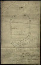
Plan of Race Course Charlottetown Royalty
Description: Plan of the Old Race Course in Charlottetown Royalty. (No.21). Shows lots and residents.
Province: Prince Edward Island
Type: cadastral maps

P.E.I. Railway Murray Harbour Branch: Plan of Spur Line and Ballast Pit at Surrey
Description: Prince Edward Island Railway. Murray Harbour Branch. Plan of Spur Line and Ballast Pit at Surrey (No.1159). Plan produced by H. Laurence, Engineer in Charge. Shown are roads, the railway, lots, and… more
Province: Prince Edward Island
Type: cadastral maps
Date Created: 1908-12-02

Plan of marsh lands on the two sides of the Pisquid River
Description: Plan of marsh lands on the two sides of the Pisquid River. Lot 37. (No.68, Queens Co.) The map shows lots, residents, measurements, and acerage.
Province: Prince Edward Island
Type: cadastral maps
Date Created: 1897-12

Plan of Lot 31
Description: Plan of Lot 31 (No.2). Mainly outline. Shows Refugee Share drawn for in Council, 12 February, 1784. Signed by John Russell Spence, Clerk of the Council.
Province: Prince Edward Island
Type: cadastral maps
Date Created: 1784

Prince Edward Island Railway Plan showing right of way of the Murray Harbour Branch through Queen…
Description: Prince Edward Island Railway Plan showing right of way of the Murray Harbour Branch through Queen's County from Village Green to Pisquid Road. (Plan No.6) The map shows lots, residents, railway… more
Province: Prince Edward Island
Type: cadastral maps

Plan of Lot 48
Description: Plan of Lot 48. Incomplete. Shows names of residents, acreage, and some land conveyance references for the eastern part of the lot, roads and bodies of water.
Province: Prince Edward Island
Type: cadastral maps