Displaying 109 - 135 of 147
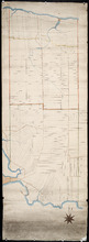
Untitled
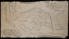
Description: Unfinished plan of Lot 45. The map shows some lots, residents, and bodies of water.
Province: Prince Edward Island
Type: cadastral maps
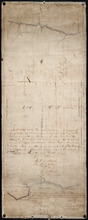
Lot No. 46
Description: Plan of Lot 46 (No.1) divided into two parts and drawn for in Council, Oct. 24, 1786. The map shows Lot 46 divided into two parts--Division No. 1 (west) and Division No. 2 (east)--of 10,000 acres… more
Province: Prince Edward Island
Type: cadastral maps
Date Created: 1786-10-24
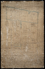
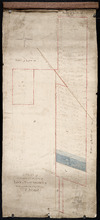
Plan of the Northern Moiety of Lot 45: compiled from surveys made by L.N. Gall and H.J. Cundall.
Description: Plan of the northern moiety of Lot 45 compiled from surveys made by L.N. Gall and H.J. Cundall. Plan referred to in deed to Commissioner of Public Land, dated 13th July, 1866. The map of the northern… more
Province: Prince Edward Island
Type: cadastral maps
Date Created: 1866
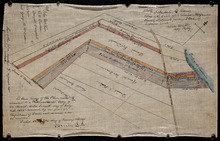
Plan of part of Lot 47: The Estate of the late Alexander McDonald showing allotments pursuant to…
Description: Plan of part of Lot 47. The estate of the late Alexander McDonald showing allotments pursuant to Order of Supreme Court Schedule G. The map shows the estate of the late Alexander McDonald divided… more
Province: Prince Edward Island
Type: cadastral maps
Date Created: 1885-07-07
Plan of part of Lot 47: The estate of the late Alexander McDonald showing the different kinds of…
Description: Plan of part of Lot 47. The estate of the late Alexander McDonald showing the different kinds of land. Schedule F. The map, drawn in black ink, shows the estate of the late Alexander McDonald divided… more
Province: Prince Edward Island
Type: cadastral maps
Date Created: 1885-07-07
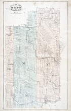
A Plan of the Eastern or C Division of Lot or Township No. 51: St. Georges Parish, Kings Coutnry, P…
Description: Plan of the eastern division of Lot 51. Montgomery Estate. The map shows the C Division of Lot 51 divided into numbered parcels of land with the names of owners or occupants with their corresponding… more
Province: Prince Edward Island
Type: cadastral maps
Plan of Lot or Township No. 51 in Kings County Prince Edward Island: Surveyed by G. Wright Jr. in…
Description: Plan of Lot 51 (No.141). Shows residents, lots, bodies of water such as rivers, and roads.
Province: Prince Edward Island
Type: cadastral maps
Date Created: 1836
Lot 37, Queens County: Lot 38 Kings County
Description: The map shows lot 37 in Queens county and lot 38 in Kings county. Shown are the Gulf of St. Lawrence, Savage Harbour, landowners, acreage, roads, railroads, and rivers.
Publisher: Cummins Map Co.
Province: Prince Edward Island
Type: cadastral maps
Date Issued (Source): 1927
Lot 39: Kings County
Description: The map shows lot 39 in Kings county. Shown are the Gulf of St. Lawrence, St. Peters bay, landowners, acreage, roads, railroads, Stukeley Ponds, and sands hills.
Publisher: Cummins Map Co.
Province: Prince Edward Island
Type: cadastral maps
Date Issued (Source): 1927
Lots 40 and 41: Kings County
Description: The map shows lots 40 and 41 in Kings county. Shown are the Gulf of St. Lawrence, St. Peters Bay, landowners, acreage, roads, and railroads.
Publisher: Cummins Map Co.
Province: Prince Edward Island
Type: cadastral maps
Date Issued (Source): 1927
Lot 42: Kings County
Description: The map shows lot 42 in Kings county. Shown are the Gulf of St. Lawrence, points, landowners, acreage, roads, and railroads.
Publisher: Cummins Map Co.
Province: Prince Edward Island
Type: cadastral maps
Date Issued (Source): 1927
Lots 43 and 44 : Kings County
Description: The map shows lots 43 and 44 in Kings county. Shown are the Gulf of St. Lawrence, bays, points, rivers, landowners, acreage, roads, and railroads.
Publisher: Cummins Map Co.
Province: Prince Edward Island
Type: cadastral maps
Date Issued (Source): 1927

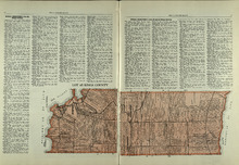
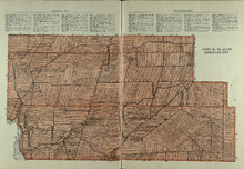
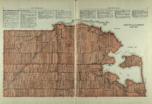
Plan of Lot Thirty Seven : Plan of Lot Thirty Eight: Queens Co., P.E.I.. Kings Co., P.E.I.
Description: The map shows lot 37 (coloured in pink) in Queens county, and lot 38 (coloured in blue) in Kings county. Shown are roads, railroads, landowners and acreage, rivers, ponds, harbours, gulfs, creeks,… more
Publisher: J. H. Meacham & company
Province: Prince Edward Island
Type: cadastral maps
Date Issued (Source): 1880
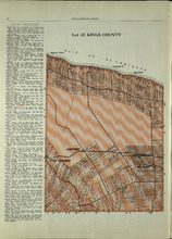
Lot 45: Kings County
Description: The map shows lot 45 in Kings county. Shown are the Gulf of St. Lawrence, Colville bay, landowners, acreage, roads, and railroads.
Publisher: Cummins Map Co.
Province: Prince Edward Island
Type: cadastral maps
Date Issued (Source): 1927
Lots 46 and 47 : Kings County
Description: The map shows lots 46 and 47 in Kings county. Shown are the Gulf of St. Lawrence, points, rivers, coves, landowners, acreage, roads, railroads, lakes, and sand.
Publisher: Cummins Map Co.
Province: Prince Edward Island
Type: cadastral maps
Date Issued (Source): 1927
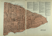
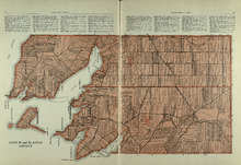
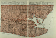
Plan of Lots Fourty Three & Fourty Four: Kings Co., P.E.I.
Description: The map shows lots 43 & 44 in Kings county. Shown are bays, gulfs, rivers, coves, capes, roads, railroads and stations, landowners and acreage, crosses, post offices, churches, and factories.… more
Publisher: J. H. Meacham & company
Province: Prince Edward Island
Type: cadastral maps
Date Issued (Source): 1880
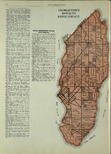
Georgetown Royalty: Kings County
Description: The map shows Georgetown Royalty in Kings county. Shown are landowners, acreage, Brudenell and Cardigan River, Albion Bay, roads, and railroads.
Publisher: Cummins Map Co.
Province: Prince Edward Island
Type: cadastral maps
Date Issued (Source): 1927
Lots 51, 52, and 66: Kings County
Description: The map shows lots 51, 52, and 66 in Kings County. Shown are Brown Creek, Montague River, Landowners, acreage, roads, and railroads.
Publisher: Cummins Map Co.
Province: Prince Edward Island
Type: cadastral maps
Date Issued (Source): 1927
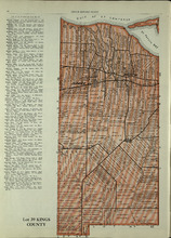
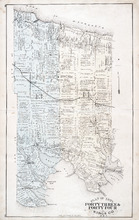
Plan of Lot Thirty Nine: Kings Co., P.E.I.
Description: The map shows lot 39 in Kings county. Shown are a gulf, lake, sand, light house, post offices, landowners and acreage, roads, railroads and stations, rivers, school houses, churches, and an Indian… more
Publisher: J. H. Meacham & company
Province: Prince Edward Island
Type: cadastral maps
Date Issued (Source): 1880
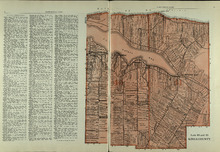
Plan of Lot Fourty: Kings Co., P.E.I.
Description: The map shows Lot 40 in Kings county. Shown are a bay, gulf, river, ponds, school house, churches, wharf, post office, roads, landowners and acreage, and mills. Compass.
Publisher: J. H. Meacham & company
Province: Prince Edward Island
Type: cadastral maps
Date Issued (Source): 1880
Lots 55 and 56: Kings County
Description: The map shows lots 55 and 56 in Kings county. Shown are bays, rivers, ponds, landowners, acreage, roads, coves, and Boughton Island.
Publisher: Cummins Map Co.
Province: Prince Edward Island
Type: cadastral maps
Date Issued (Source): 1927
Lots 59 and 61: Kings County
Description: The map shows lots 59 and 61 in Kings county. Shown are Montague river, bays, points, coves, landowners, acreage, roads, creeks, and Panamure Island.
Publisher: Cummins Map Co.
Province: Prince Edward Island
Type: cadastral maps
Date Issued (Source): 1927
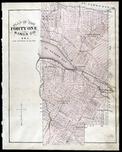
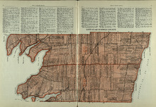
Plan of Lot Forty One: Kings Co., P.E.I.
Description: The map shows lot 41 in Kings county. Shown are St. Peters bay, river, gulf, roads, landowners and acreage, railroad and station, post offices, mills, schools, and churches. Compass.
Publisher: J. H. Meacham & company
Province: Prince Edward Island
Type: cadastral maps
Date Issued (Source): 1880
Plan of Lots 51, 52, & 66: Kings Co., P.E.I.
Description: The map shows lots 51, 52, & 66 in Kings county. Shown are roads, railroads and stations, landowners and acreage, streams, rivers, post offices, mills, and churches. Graphic compass.
Publisher: J. H. Meacham & company
Province: Prince Edward Island
Type: cadastral maps
Date Issued (Source): 1880
Lots 63 and 64: Kings County
Description: The map shows lots 63 and 64 in Kings county. Shown are Northumberland Strait, Gulf of St. Lawrence, Murray Harbour, Island and River, points, Herring Ponds, landowners, acreage, roads, and railroads.
Publisher: Cummins Map Co.
Province: Prince Edward Island
Type: cadastral maps
Date Issued (Source): 1927
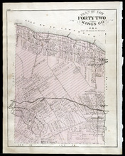
Plan of Lot Forty Two: Kings Co., P.E.I.
Description: The map shows lot 42 in Kings county. Shown are a gulf, marsh, roads, railroad and stations, post offices, school houses, rivers, and a brook. Compass.
Publisher: J. H. Meacham & company
Province: Prince Edward Island
Type: cadastral maps
Date Issued (Source): 1880
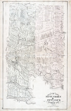
Plan of Lots Fifty Three & Fifty Four: Kings Co., P.E.I.
Description: The map shows lots 53 & 54 in Kings county. Shown are roads, railroads and stations, landowners and acreage, rivers, creeks, wharfs, post offices, and mills. Graphic compass.
Publisher: J. H. Meacham & company
Province: Prince Edward Island
Type: cadastral maps
Date Issued (Source): 1880