Displaying 82 - 108 of 147
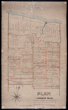
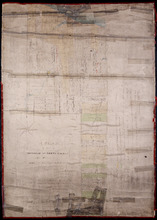
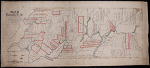
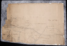
Plan of Township No. 45. Copied from Plan furnished by Proprietors, and amended and corrected from…
Description: Plan of the northern part of Lot 45 copied from Plan furnished by Proprietors and amended and corrected from surveys by J.C. Underhay (No.124). Cunard Estate. Shows names of residents, acreage, land… more
Province: Prince Edward Island
Type: cadastral maps
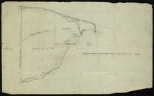
Plan of part of Lot 44
Description: Plan of part of Lot 44. Area east of the Bear River Road. Shows names of residents.
Province: Prince Edward Island
Type: cadastral maps
Plan of Lot 44 (No.119)
Description: Plan of Lot 44 (No.119). Cunard Estate. Shows names of some residents, acreage, and some land conveyance references, bodies of water such as the Gulf of St. Lawrence, rivers, roads, and a nautical… more
Province: Prince Edward Island
Type: cadastral maps
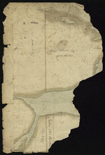
Plan of the southern part of Lot 43
Description: Plan of the southern part of Lot 43. Shows names of residents and acreage, bodies of water such as rivers (Fortune), bays (Rollo), capes, roads, division lines, and a nautical compass. (Townshend)
Province: Prince Edward Island
Type: cadastral maps
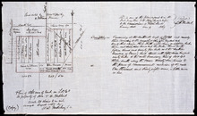
A Plan of Part of Township No. Forty Three. The Property of Hon. T. H. Haviland. Surveyed October…
Description: Plan of part of Lot 43. The property of Hon. T.H. Haviland. One of the plans referred to in the Deed from Hon. T.H. Haviland and wife to the Commissioner of Public Lands, 1869. Shows names and… more
Province: Prince Edward Island
Type: cadastral maps
Date Created: 1868-10
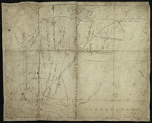
Plan of Township No 42: from Surveys by O. Curtis, August 1864
Description: Plan of Lot 42. Shows names of some residents and acreage, bodies of water such as the Gulf of St. Lawrence, roads, and a compass.
Province: Prince Edward Island
Type: cadastral maps
Date Created: 1864-08
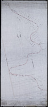
Plan of the western half of Lot 40 and Lot 39 east of Morell River
Description: Plan of the western half of Lot 40 and the part of Lot 39 east of Morell River. Shows names of residents and acreage, bodies of water such as bays, and rivers, and roads.
Province: Prince Edward Island
Type: cadastral maps
A Plan of 1068 Acres of Land on Lot 40, The Property of Hon. T. H. Haviland
Description: Plan of part of Lot 40 (No.108). 1068 acres of land, the property of Hon. T.H. Haviland. One of the plans referred to in the Deed from Hon. T.H. Haviland and wife to the Commissioner of Public Lands… more
Province: Prince Edward Island
Type: cadastral maps
Date Created: 1868-08
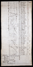
Plan of Lot or Township No. 66: from the latest Surveys by Jos. Ball S. G. Surveyor General's…
Description: Plan of Lot 66. Copied by Thomas W. May, July 8, 1921. This copy of an earlier map shows Lot 66 divided into numbered parcels of land. A list down the right side gives the residents' names and… more
Province: Prince Edward Island
Type: cadastral maps
Date Created: 1856-08-04
Plan of Township 64
Description: Plan of Lot 64 (No.169). Cunard Estate. Shows names of residents, acreage, and land conveyance references. The map shows bodies of water such as Gulf of Saint Lawrence, and Murray River, Murray… more
Province: Prince Edward Island
Type: cadastral maps
Plan of Lot 63
Description: Plan of Lot 63. Shows names of residents, acreage, and land conveyance references. The map shows bodies of water such as Murray Bay/River, Gulf of St. Lawrence, and Murray Islands.
Province: Prince Edward Island
Type: cadastral maps
A Plan of Lot No. 61: By John Aldous from survey made in May & June 1842
Description: Plan of Lot 61 (No.162). Sullivan Estate. Landlord's plan. Shows names of residents and acreage. Signed by G.W. DeBlois. The map shows roads, bodies of water such as Sturgeon Bay and River,… more
Province: Prince Edward Island
Type: cadastral maps
Plan of Lot 59 (No.156)
Description: Plan of Lot 59 (No.156). Montgomery Estate. Shows names, acreage, and land conveyance references for some residents, roads, and a nautical compass.
Province: Prince Edward Island
Type: cadastral maps
A Plan of the undisposed part of 1/3 of Lot No. 59 Kings County in Prince Edward Island belonging…
Description: A plan of the undisposed part of Lot 59 belonging to the Earl of Selkirk (No.158). Shows names of residents, acreage, and land conveyance references. Surveyed by Rod'k Campbell.The map shows… more
Province: Prince Edward Island
Type: cadastral maps
Plan of Township No. 59: Compiled from the proprietors plans, descriptions in leases and registered…
Description: Plan of Lot 59 compiled from the proprietors' plans, descriptions in leases and registered deeds, and from Meacham's Atlas with additions and corrections from surveys made at various times… more
Province: Prince Edward Island
Type: cadastral maps
Date Created: 1922-03
Plan of Township No. 56: referred to in the annexed Deed shewing the situation of lands conveyed by…
Description: Plan of Lot 56 showing the situation of 18,028 acres of land conveyed by T. Heath Haviland and G.W. DeBlois to the Commissioner of Public Lands. The map shows Lot 56 divided into parcels of land with… more
Province: Prince Edward Island
Type: cadastral maps
A Plan of Township No. 56 in Kings County P. E. Island, the Property of Hon. T. H. Haviland of…
Description: Plan of Lot 56 (No.149). Property of Hon. T.H. Haviland of Charlottetown. Shows names of residents and acreage, bodies of water such as rivers, bays, creeks, ponds, roads, and a nautical compass.
Province: Prince Edward Island
Type: cadastral maps
Date Created: 1864
Plan of Lot 61 - Untitled
Description: Plan of Lot 61 (No.163). Sullivan Estate. Shows names of residents, acreage, and some land conveyance references bays and a nautical compass pointing North.
Province: Prince Edward Island
Type: cadastral maps
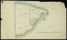
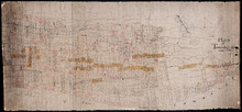
Part of Lot 38
Description: Plan of part of Lot 38 (No. 8). Coffin property. 220 acres of land bordering on Savage Harbour. The map shows the northwestern-most part of Lot 38 that is separated from the rest of the lot by Savage… more
Province: Prince Edward Island
Type: cadastral maps
Part of Lot No. 38
Description: Plan of part of Lot 38 (No. 8), Coffin property. 220 acres of land bordering on Savage Harbour. The map shows the northwestern-most part of Lot 38 that is separated from the rest of the lot by Savage… more
Province: Prince Edward Island
Type: cadastral maps

Part of Lot 38
Description: Plan of part of Lot 38 (No. 9). 1100 acres, the property of Alex Watts. The map shows part of Lot 38, including a parcel of land belonging to Alexander Watts. It gives the names of several other… more
Province: Prince Edward Island
Type: cadastral maps
Part of Lot 38: No. 13
Description: Plan of part of Lot 38 (No.13). 900 acres, the property of Alex Watts. Part of plan is missing. The map shows a 900-acre parcel of land belonging to Alexander Watts Esqr. in the northwestern corner… more
Province: Prince Edward Island
Type: cadastral maps
Part of Lot 38: No. 14
Description: Plan of part of Lot 38 (No. 14). Capt. Bentinck's land. The map shows a parcel of land belonging to Captain Bentinck, north of the Hillsborough River in Lot 38. It gives names of residents and… more
Province: Prince Edward Island
Type: cadastral maps

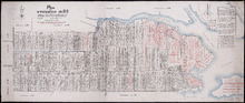
Map of Prince Edward Island in the Gulf of St. Lawrence: for McGregor's British America
Publisher: Ballantyne and Company
Province: Prince Edward Island
Type: cadastral maps, topographic maps
Date Created: 1832
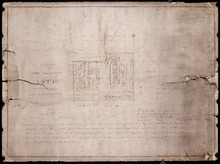
Plan of part of the Railway appropriations in Lot 45: Harmony Station
Description: Plan of part of the Railway appropriations in Lot 45. Harmony Station. The map shows roads, residents and acreage.
Province: Prince Edward Island
Type: cadastral maps
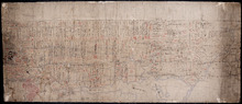
Plan of Lot No. 38 [? title partly missing]
Description: Plan of part of Lot 38 and part of Lot 39. Savage Harbour area. The map shows northern portions of Lot 38 and Lot 39 divided into parcels of land with names of residents and acreage amounts. It shows… more
Province: Prince Edward Island
Type: cadastral maps