Displaying 406 - 432 of 845
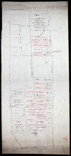
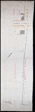
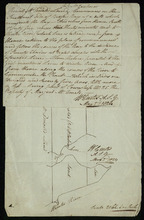
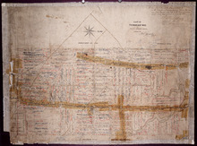
Plan of the property of Mrs. S.W. Smith situated on Township No. 33 in Prince Edward Island
Description: Plan of part of Lot 33. The property of Mrs S.W. Smith. The map shows Winter River, and roads (Brackley Point), (Union), and a compass.
Province: Prince Edward Island
Type: cadastral maps
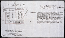
A Plan of 1068 Acres of Land on Lot 40, The Property of Hon. T. H. Haviland
Description: Plan of part of Lot 40 (No.108). 1068 acres of land, the property of Hon. T.H. Haviland. One of the plans referred to in the Deed from Hon. T.H. Haviland and wife to the Commissioner of Public Lands… more
Province: Prince Edward Island
Type: cadastral maps
Date Created: 1868-08
Plan Shewing the situation of that part of Water Lot No. 7. at Charlottetown Sold to Henry Beer Esq.
Description: Plan showing the situation of that part of Water Lot No.7 at Charlottetown sold to Henry Beer. (No.26) (Also No.216 Queens County). The map shows streets such as Great George, Prince, Water, wharfs,… more
Province: Prince Edward Island
Type: cadastral maps
Date Created: 1881
Plan Shewing the situation of Water Lot No. 8, and that part of Water Lot No. 7 conveyed to Ronald…
Description: Plan showing the situation of Water Lot No.8 and that part of Water Lot No.7 conveyed to Ronald MacMillan. The map also shows streets such as Water street, Prince, lots, Ferry Wharf, and Hillsborough… more
Province: Prince Edward Island
Type: cadastral maps
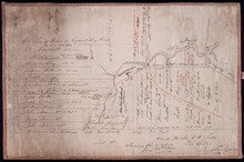
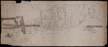
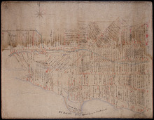
Plan of part of Charlottetown showing Pownal Wharf and Lot No.5
Description: Plan of part of Charlottetown showing Pownal Wharf and part of Town Lot No.5 located in 1st Hund. Also shown are buildings and wharfs.
Province: Prince Edward Island
Date Created: 1868-08
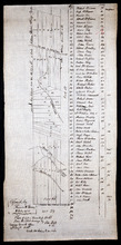
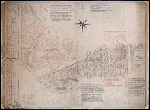
Plan of Lot or Township No. 66: from the latest Surveys by Jos. Ball S. G. Surveyor General's…
Description: Plan of Lot 66. Copied by Thomas W. May, July 8, 1921. This copy of an earlier map shows Lot 66 divided into numbered parcels of land. A list down the right side gives the residents' names and… more
Province: Prince Edward Island
Type: cadastral maps
Date Created: 1856-08-04
Plan of the western part of Lot 16
Description: Plan of the western part of Lot 16. Shows names of residents, acreage, and a few land conveyance references. The map shows bodies of water, roads, other lots such as 15, and 18 in Indian River, a… more
Province: Prince Edward Island
Type: cadastral maps
Date Created: 1880-01-24
Plan of Township No. 20
Description: Plan of the western moiety of Lot 20 (No.50). Copy of the plan deposited by vendors of the Cunard Estate. The map also shows bodies of water such as rivers, creeks, and ponds, and roads.
Province: Prince Edward Island
Type: cadastral maps
Plan of the Western Moiety of Township, No. 20. Situate in Grenville Parish. Queens Co. P.E.Island…
Description: Plan of the Western Moiety of Lot 20 situate in Grenville Parish (No.49). Includes that part of Lot 20 south of the South West River. Shows names of residents and acreage, bodies of water such as… more
Province: Prince Edward Island
Type: cadastral maps
Eastern Moiety of Township No. 20
Description: Plan of the eastern moiety of Lot 20. Color code shows property of William Cundall, Louisa Montgomery, Eliza M. Cundall and Henry J. Cundall. Cundall Estate (No.51). Shows names of residents and… more
Province: Prince Edward Island
Type: cadastral maps
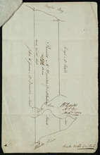
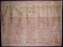
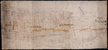
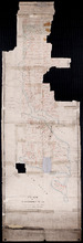
Plan of the French Marsh: Lot 37 - No. 10
Description: Plan of part of Lot 37 (Nos. 10 and 58). This item consists of three maps on three separate sheets, all showing the same area. The maps show the French Marsh on the north side of the Hillsborough… more
Province: Prince Edward Island
Type: cadastral maps, topographic maps
A Plan of Ronald McDonalds Land of Grand Tracadie For The Surveyors Generals Office
Description: Plan of part of Lot 35 (No. 5). The map shows 175 acres of land belonging to Ronald McDonald at Grand Tracadie in the northern part of Lot 35. The map shows the names of the residents on either side… more
Province: Prince Edward Island
Type: cadastral maps
Date Created: 1824-08-03
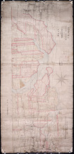
Plan of part of Lot 21: No. 55
Description: The map shows the southern portion of Lot 21 divided into parcels of land with the names of resident and their acreage amounts. Some parcels are outlined in red. Land conveyance information appears… more
Province: Prince Edward Island
Type: cadastral maps
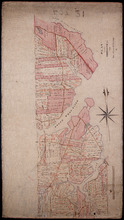
Plan of part of Township No. 21 Grenville Parish, Queens County P.E.Island: H.J. Cundall delt 1850
Description: Plan of the northern part of Lot 21 (No.56). Cunard Estate. One of the plans referred to in the deed from Sir Edward, William, and Laura Cunard to the Commissioner of Public Land, July 13, 1866.… more
Province: Prince Edward Island
Type: cadastral maps
Date Created: 1850
Plan of part of Township No. 21: Copied from a Plan of H,J, Cundall's
Description: Plan of the northern part of Lot 21 (No.57). Cunard Estate. Shows names of residents, acreage, and some land conveyance references, bodies of water such as rivers, and the Gulf of Saint Lawrence,… more
Province: Prince Edward Island
Type: cadastral maps
Part of Township No. 21: in Prince Edward Island
Description: Plan of the southern half of Lot 21. One of the plans referred to in the Deed from Sir Edward, William and Laura Cunard to the Commissioner of Public Land, July 13, 1866. Shows names of residents,… more
Province: Prince Edward Island
Type: cadastral maps

Plan of Township No. 67 in Prince Edward Island: The Property of Lady Wood
Description: Plan of Lot 67 (No.180). The property of Lady Wood. Shows names of residents, acreage, and some land conveyance references and a compass pointing North.
Province: Prince Edward Island
Type: cadastral maps
Date Created: 1858
Plan of 1390 Acres of Land part of Township No. 65: The Property of the Honble. Samuel Cunard.…
Description: Plan of Lot 65 (No.178). Shows names of residents, acreage, and land conveyance references. Color code indicates freehold land and the estates of the Wrights, Cunard and Cumberland. Shows bodies of… more
Province: Prince Edward Island
Type: cadastral maps
Plan of Part of Township No. 65: The Property of Col. B.H. and Mrs Cumberland
Description: Plan of part of Lot 65 (No.171). The property of Col. B.H. and Mrs Cumberland. Shows names of residents and acreage. Plan copied by R.T. Weeks. The map shows bodies of water such as Elliott River,… more
Province: Prince Edward Island
Type: cadastral maps
Plan of Township 64
Description: Plan of Lot 64 (No.169). Cunard Estate. Shows names of residents, acreage, and land conveyance references. The map shows bodies of water such as Gulf of Saint Lawrence, and Murray River, Murray… more
Province: Prince Edward Island
Type: cadastral maps
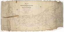
Map of Prince Edward Island, in the Gulf of St. Lawrence,: Compiling the latest Topographical…
Description: Map of Prince Edward Island by George Wright, Surveyor General, 1852. The Sea Coast, Rivers, Vc. being laid down from the Survey recently completed by Captain H. W. Bayfield R.N. The map shows mail… more
Province: Prince Edward Island
Type: cadastral maps
Date Created: 1852
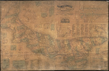
Topographical Map of Prince Edward Island in the Gulf of St. Lawrence
Description: Prince Edward Island divided into Counties and Parishes with the Lots as granted by Government, exhibiting all the New Settlements, Roads, Mills, etc. Published by H. Ashby, King Street, Cheapside,… more
Publisher: W. E. & H. H. Baker
Province: Prince Edward Island
Type: topographic maps, cadastral maps, pictorial maps
Date Created: 1863
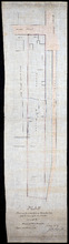
Plan of Lot 63
Description: Plan of Lot 63. Shows names of residents, acreage, and land conveyance references. The map shows bodies of water such as Murray Bay/River, Gulf of St. Lawrence, and Murray Islands.
Province: Prince Edward Island
Type: cadastral maps
A Plan of the undisposed of Parts of Lot No. 62 in Queens County in Prince Edward Island by Rodk.…
Description: A plan of the undisposed part of Lot 62. Selkirk Estate (No.164). Shows names of residents and acreage.
Province: Prince Edward Island
Type: cadastral maps
Date Created: 1860
Plan of Lot 62 (No.165)
Description: Plan of Lot 62 (No.165). Selkirk Estate. Shows names of residents, acreage, and land conveyance references. The map shows a division line, bodies of water, Wood Islands, lots, landowners, acreage,… more
Province: Prince Edward Island
Type: cadastral maps
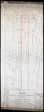
Plan of Township No. 55: From various Surveys made between the Years 1818 and 1845
Description: The map is a Plan of Township No. 55. The mqp shows bodies of water such as the Cardigan River, and Boughton River, lots, landowers, acreage, and Boughton Island.
Province: Prince Edward Island
Type: cadastral maps
Date Created: 1848-03-21