Displaying 298 - 324 of 845
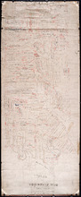
Plan of Lot 54. Incomplete.
Description: Plan of Lot 54. Incomplete. Shows names of some residents, lots, acreage, roads, and bodies of water such as creeks.
Province: Prince Edward Island
Type: cadastral maps
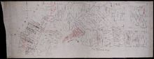
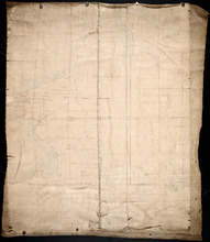
Plan of Lot 54
Description: Plan of Lot 54. Shows names of residents, lots, roads, and bodies of water such as rivers.
Province: Prince Edward Island
Type: cadastral maps

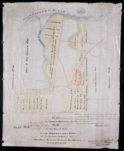
A Plan showing the Position of the Line of Road through, proposes to be run through Lot 47 from…
Description: Plan of existing and proposed road through Lot 47 from George Munn's, West River, to the bridge on the north side of Surveyor's Pond. Distance of 4 miles and 2 chains. Road run under the… more
Province: Prince Edward Island
Type: cadastral maps
Date Created: 1851-08
Plan of a Part of Township No. 35 on the South Side of the Hillsborough River: Those portions…
Description: Plan of part of Lot 35 on the south side of the Hillsborough River showing the property of Rev. John Alister Somerlet MacDonald. Copied from a tracing by W.C. Harris in the Land Office (Plan No.3).… more
Province: Prince Edward Island
Type: cadastral maps
Date Created: 1878

Partial plan of Lot 48
Description: Partial plan of Lot 48. Mainly outline. Shows names of some residents in southern half of Lot. The map shows residents and lots, and roads.
Province: Prince Edward Island
Type: cadastral maps

Plan of Murray River Lot 63: North of the River
Description: Plan of part of Murray River, Lot No.63. Area north of the River and west of Main Street. The map shows residents, lots, acreage, roads, towns, and a nautical compass.
Province: Prince Edward Island
Type: cadastral maps
Date Created: 1958

Plan of Lot 49
Description: Plan of Lot 49 (No.6). Outline.
Province: Prince Edward Island
Type: cadastral maps

Plan showing the situation of the line of road from Melville Road to Appin Road also the connecting…
Description: Plan showing the situation of the line of road from Melville Road to Appin Road; also, the connecting road leading to Crapaud Wharf. Roads pass through Lots 29 and 30. (No.15, Queen's). Shown… more
Province: Prince Edward Island
Type: cadastral maps
Date Created: 1868-06-08
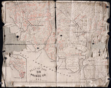
Plan of Lot 28: Prince Co. P.E.I.
Description: Printed map of Lot 28. Names and land conveyance references have been added in red ink. The map shows residents, lots, roads, bodies of water such as rivers, towns, and cities, buildings, and an… more
Province: Prince Edward Island
Type: cadastral maps

Plan of New Line Road from South Wiltshire Road Lot 31 to Emyvale Road Lot 65
Description: Plan of new line of road from South Wiltshire Road, Lot 31, to Emyvale Road, Lot 65. The map shows lots, roads, and residents.
Province: Prince Edward Island
Type: cadastral maps
Date Created: 1892-12-29
Plan of Township No. 56: Copied from the Survey of J. C. Underhay By Owen Curtis. L. S.
Description: Plan of Lot 56 (No.150). Shows names of residents, acreage, and some land conveyance references. Surveyed by J.C. Underhay and copied by Owen Curtis. The map also shows bodies of water such as… more
Province: Prince Edward Island
Type: cadastral maps
Plan of Lot 50
Description: Plan of Lot 50. Shows names of residents, acreage, and some land conveyance references, roads, and bodies of water such as rivers (Orwell), and bays (Pownal).
Province: Prince Edward Island
Type: cadastral maps

Plan of Township No. 55: Compiled from the plans on file in the Land and Registry Offices, from the…
Description: Plan of Lot 55 compiled from the plans on file in the Land and Registry Offices, from the descriptions in the registered Grants and from Meacham's Atlas. Shows names of residents, acreage, and… more
Province: Prince Edward Island
Type: cadastral maps
Date Created: 1919

Township No. Fiftyfour. St. Georges Parish. Kings County. Prince Edward Island.: Chiefly from…
Description: Plan of Lot 54 (No.145). Shows names of residents, acreage, and some land conveyance references. Copied by H.J. Cundall. Certified plan. The map also shows bodies of water such as rivers (Cardigan),… more
Province: Prince Edward Island
Type: cadastral maps

Plan of Township No. 9: compiled from the proprietors' plans and the descriptions in the…
Description: Plan of Lot 9 compiled from the proprietors plans and the descriptions in the leases and deeds, with additions and corrections from the various surveys. The map shows Lot 9 divided into parcels of… more
Province: Prince Edward Island
Type: cadastral maps
Date Created: 1909

Plan of Township No. 11: compiled from the plans by the late Alexander Anderson L. S on file in the…
Description: The map shows Lot 11 divided into parcels of land with names of residents, their acreage amounts and land conveyance references. Shows the P.E.I. Railway in red, roads in light brown. Bodies of water… more
Province: Prince Edward Island
Type: cadastral maps
Date Created: 1910

Plan of Township No. 32: compiled from the proprietors plans and Meacham's Atlas and from the…
Description: The map shows Lot 32 divided into parcels of land with names of residents, acreage amounts and land conveyance references. Areas drawn in black indicate government land; areas in red indicate… more
Province: Prince Edward Island
Type: cadastral maps
Date Created: 1919-01

Plan of Township No. 56: referred to in the annexed Deed shewing the situation of lands conveyed by…
Description: Plan of Lot 56 showing the situation of 18,028 acres of land conveyed by T. Heath Haviland and G.W. DeBlois to the Commissioner of Public Lands. The map shows Lot 56 divided into parcels of land with… more
Province: Prince Edward Island
Type: cadastral maps

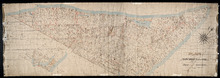
Plan Shewing the position of the Northern points of Commencement of the Lines dividing Lots 33 and…
Description: The map shows northern portions of Lots 24, 33, 34 and 35 along the north shore of Prince Edward Island. It shows the northern-most sections of three boundary lines: the line dividing Lots 24 and 33… more
Province: Prince Edward Island
Type: chorographic maps
Date Created: 1835-05-07
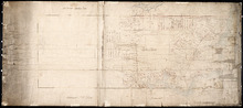
Plan of Lot 1
Description: Plan of Lot 1 comprising the Palmer and part of the Cunard Estates. Surveyed by V.S. Gillis and others. Rolled map on fabric backing. Water is coloured blue. Properties include owner / occupant names… more
Province: Prince Edward Island
Type: cadastral maps
Date Created: Unknown year


Plan of Lot or Township No. 6 in Prince Edward Island: From Actual Survey by A. Anderson, Land…
Description: Plan of Lot 6. Northern half shows residents.
Province: Prince Edward Island
Type: cadastral maps

Plan of Township No. 13: From a Survey by Alex Anderson Copied from a Plan made by John Clay…
Description: Plan of Lot 13 - Yeo Estate.
Province: Prince Edward Island
Type: cadastral maps
Date Created: 1878

Plan of Township No. 16 in Prince Edward Island: The Estate of Laurence Sulivan Esq., Dept. Sect.…
Description: Plan of Lot 16, the estate of Lawrence Sullivan, Esq. Copied by Geo. Wright from a plan by James(?).
Province: Prince Edward Island
Type: cadastral maps
Date Created: 1851

Plan of Township No. 57: Compiled from the proprietors plans and Meacham's Atlas, and from the…
Description: The map shows Lot 57 divided into parcels of land with names of residents, acreage amounts and land conveyance references. Areas drawn in black indicate land conveyed to the government and re-… more
Province: Prince Edward Island
Type: cadastral maps
Date Created: 1917
A Plan of Lot 18: situated in Prince County in the Island of St. John enlarged and Drawn from the…
Description: Sketch plan of Lot 18 (Plan No.46) showing property of Peter Stewart, Robert Stewart, and Wm. Allanby. Surveyed by Thomas Wright. Office copy by Jos. Ball and certified by Geo. Wright. Original was… more
Province: Prince Edward Island
Type: cadastral maps
Date Created: 1847-04-06